Asker
The Synthetic Site Folder and Site Brief are available for free.
Please register and login to access the Complete Site Folder.
- Synthetic site folder EN
- Site on Google Maps
- Back to map
Data
Category Urban - architectural
Team representative Architect - urban planner - landscape architect
Location Dikemark - Asker municipality
Population Asker 57,238 - Dikemark 1,300
Strategic site 1500 ha - Project site 11 ha
Site proposed by Asker municipality, Oslo University Hospital and Oslo municipality
Owner(s) of the site Oslo municipality, Oslo University Hospital
Commision after competition Zoning plan, possibility for a building commission
More Information
How can the site contribute to the adaptable city?
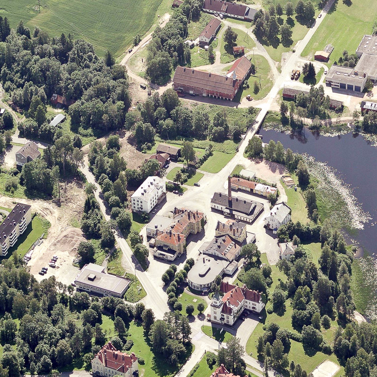
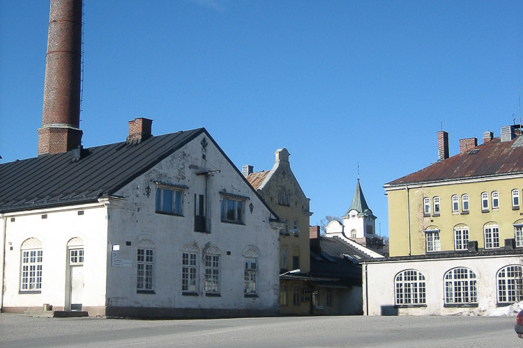
Peacefully situated in pastoral surroundings just outside of the city, Dikemark was considered the perfect location for Oslo’s new psychiatric hospital at the turn of the20th century. As its activity related to psychiatric treatment has been phased out over the years, today most of the buildings stand empty and have been listed for protection. Now the entire area needs to be adapted to a new time and filled with new content.
City strategy
Dikemark is in many ways a unique place within its regional context thanks to its preserved, landmark architecture, its picturesque landscape and its history and identity. Yet, in spite of all its qualities, Dikemark faces a great challenge as its hospital functions will be relocated to Oslo, rendering all buildings empty. How to ensure the development of a new and attractive society at Dikemark?
There is a strong wish in the municipality to establish a complete and viable society at Dikemark with jobs, private and public services.
Site definition
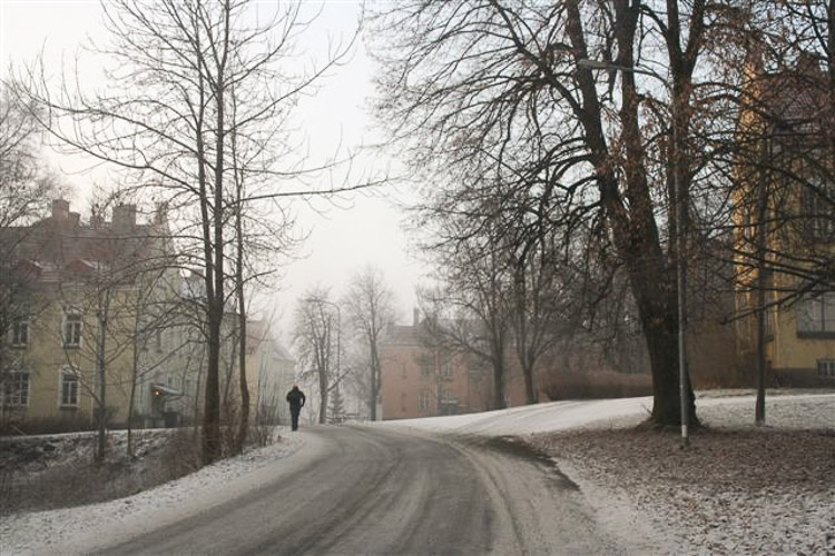
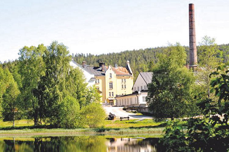
Dikemark is a place with a strong identity, first and foremost related to its former use as a psychiatric hospital, but also in its architectural and spatial qualities. The site and its buildings is located in scenic surroundings by the Verkensvannet lake, encircled by forests and fields.
An architectural landmark designed almost entirely by the architect Victor Nordan, and built between 1902 and 1934, Dikemark Hospital represents today a unique historical record of an era and moment in medical treatment.
Within the project site there is about 20 patients and administrative buildings and 15 workshops. In addition, there is staff housing, a community house and a dormitory. Together the existing buildings on the site constitute approximately 80,000 m², of which the hospital buildings comprise less than 55,000 m2.
Endowed with its own waterworks, power plant and surrounding farmland, Dikemark Hospital was almost a self-sustained community. During its heyday, it housed over 900 patients and had a staff of 1500 employees.
Adaptability: the main challenges to take into account
For the overall plan competitors are asked to investigate a total development potential between 100 000 and 250 000 sq. m. of residential and mixed-use programs (existing buildings included).
What types of functions can take place there? How to best make new use of the existing buildings?How to bring new life to the area? How to negotiate the issues of memory and preservation along with new use and adaption? Can Dikemark take on a new regional role?
The competition asks for innovative proposals that can open up for new possible futures for Dikemark.
Questions on the site
On page 19 of the competition program you talk about 'the overall plan' and how it has a development potential between 100,000 and 250,000 square meters. However, and despite the size of the 'central area' (marked with yellow on page 18), it is rather unclear what is meant by 'overall area'. Is the overall plan the one marked red on page 18?
By the phrase "the overall plan" we mean the area within the red line.
On the document ASKER-NO-C-M1-2, we observe a black dotted line. Is it a futur railroad with a station in Asker? Is it planned to create a closer station to Dikemark?
The black, dotted line, stretching from north, trough Asker centre and southwards, represents the railroad tracks in Asker. The railroad runs through a tunnel 80 m below the surface of Dikemark. There will not be established a railroad stop at DIkemark due to this vertical distance. Public transportation to Dikemark is carried out by bus. The aim is to increase the bus capacity within the municipality.
On the dxf file there is a layer LAYER-004110. It surrounds certain areas that when overlapped with the google earth image seem to be in modification (possible construction of roads). Could you clarify the status of those lands?
Construction of water- and sewage pipes. The work is now complete.
Which of the existing buildings will remain under Ullevål Sykehus as institutions?
None of the existing buildings will remain as insitutions for Oslo University Hospital. All hospital activity will be relocated.
Can the lake be used for bathing?
Yes. The lake is a popular bathing site.
Is there any possibility of entering the buildings at Dikemark?
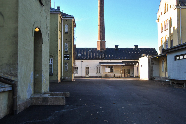
Most buildings are not open to the public. The exceptions are: the Administration building (still in operation for OUS); the Main Kitchen (holds an indian restaurant today); the Dikemark Museum (Visit by appointment); the Gallery Issa (inside the Laundry building. Visit by appointment).
Still, we would in any case encourage you to go to Dikemark and experience the landscape and the spatial qualities of the site.
The existing building is 80,000 m2 - is this for the overall plan or for the central plan?
The 80,000 sqm of existing buildings counts for the buildings within the area marked with the red line; reffered to in the program as the overall plan.
Is it possible to obtain a square meter overview of all the hospital buildings individually within the overall plan?
A file with the exact sqm overview will be uploaded to the server with the competition files, in the “additional docs” folder.
There is a part of the project area that does not appear in the dwg plan given where the building 18 and 21 are located. Should we just avoid developing the program in that area or is it possible to have that part of the plan given in another dwg?
An updated DXF file, including the missing areas, is now uploaded. File name is omrdik.DXF
Is posible to get all *.pdf site files as *.dwg format? Thank you in advance.
All the pdfs, that shows different views (in different scales) of the project site, can be "extracted" from the main DXF. The DXF contains all the information necessary to create these views.
What`s the population in Dikemark today?
1,300 people live in the Dikemark area. 600 people in connection with the hospital activity.
Could you tell us if bluidings Nº05, 06, 07, 08, 09, 11, 12, 13, 14, 16, 17, 20 are currently in use? If it is like that, which are the uses of these buildings?
Buildings 05, 06, 07, 11, 12, 16 (only partly), 17 and 20 are currently in use.
How many people live within a 2 km radius from Dikemark?
3362
How many people live within a 10 km radius from Dikemark?
It is about 10 km to the northeast border of Asker kommune and closer in the other directions, so the numbers will be approximately the same as for the municipality of Asker
What is the demography like in Dikemark (elderly/children/working age/ethnic groups/religion etc)?
See below the composition of ages at Dikemark. Unfortunately we don’t have information about ethnic groups and religion.
Radius 2 km fra Dikemark Central area
Birth
Whoman
Man
1913
1
1914
1
1918
1
1919
1
1920
3
1
1921
2
1922
1
1
1923
5
3
1924
2
2
1925
2
1
1926
2
3
1927
9
1
1928
9
3
1929
1
1
1930
4
4
1931
4
2
1932
6
5
1933
6
5
1934
5
1
1935
5
6
1936
6
7
1937
2
3
1938
9
5
1939
10
4
1940
8
6
1941
5
5
1942
6
5
1943
8
8
1944
9
13
1945
8
10
1946
9
16
1947
13
12
1948
14
11
1949
10
11
1950
4
13
1951
15
14
1952
14
15
1953
17
23
1954
22
24
1955
19
25
1956
20
22
1957
17
32
1958
22
27
1959
28
28
1960
36
26
1961
20
24
1962
32
33
1963
38
29
1964
37
38
1965
40
36
1966
37
38
1967
36
39
1968
35
30
1969
34
38
1970
32
30
1971
32
23
1972
24
28
1973
19
23
1974
28
20
1975
19
22
1976
26
22
1977
20
19
1978
13
21
1979
23
19
1980
15
15
1981
12
17
1982
17
12
1983
17
8
1984
15
14
1985
9
16
1986
8
17
1987
23
16
1988
17
12
1989
22
17
1990
18
24
1991
24
24
1992
19
36
1993
30
24
1994
24
29
1995
35
42
1996
40
31
1997
32
32
1998
31
25
1999
28
27
2000
30
25
2001
32
19
2002
31
28
2003
27
28
2004
31
26
2005
20
21
2006
30
24
2007
25
26
2008
17
17
2009
21
30
2010
14
20
2011
17
18
2012
17
12
SUM
1694
1668
What type of farming takes place in Dikemark?
Today it’s only gras production.
Is there an existing strategy for developing bicycle roads between Asker and Dikemark/the other local centres?
Asker kommune has a bicycle strategy. Most of the bicycle roads between Dikemark and Asker, Heggedal and Liertoppen are established. There are only small parts that need to be planned and made.
Many of the buildings at Dikemark have verandas or extensions. Are these original design or later additions?
The verandas are part of the original design.
Is the water mill in use today?
It was in use approximately a year ago, but at the moment the water pipes are cut due to the new water pipe system. But the plan is to use it again.
On the Cad file we have, the last part of the competition area is missing.( Stinelokka) Is it possible to get the rest of the competition area?
An updated DXF file, including the missing areas, will be uploaded soon
On the Cad file we have, a part of the site is missing. (Stinelokka) Is it possible to get a Cad file that includes the entire area?
An updated DXF file, including the missing areas, is now uploaded. File name is omrdik.DXF
Is the digital document ment to be a summary of the content of the a1 beards, or does it need to consist of new material about the project?
The idea of to digital document is to explain the content of the project by means of texts, schemes and/or drawings. As it can be up to 7 pages, there is more space available for eventual additional schemes and text. However, it is up to the competing teams to decide whether this document should lnclude additional information, not already located on the A1 boards
The dwg map does not include the entire area included in the overall plan. There is a rather big part missing to the south. Could you please publish an updated dwg map which include the entire area?
An updated DXF file, including the missing areas, is now uploaded. File name is omrdik.DXF
Three of the institution-buildings (11: Hospitset, 13: Klosteret, 16 : Kringsjå) are listet for both interior and exterior protection. Is the complete interior listed or just parts of it? Is it possible to get drawings that shows the protection of the interior in these three buildings?
For these 3 buildings the exterior and interior is listed. This includes the main elements of the building meaning the construction, façade composition, plan, use of materials and surface treatment. Also included is building components as windows, doors, fire places, chimneys, mouldings and mounted interior elements as owens, cupboards and technical installations.
This site is connected to the following theme
Heritage is generally thought to look back to the past, but conversely it could be said that it should look to the future. Heritage is usually considered to be extraordinary, but is there not a case for thinking about the definition of “ordinary heritage”? Heritage is customarily perceived as an architectural object, but this office will explore ways to “create heritage” in three types of context where it is in principle lacking: the transformation of orphan districts, the conversion of neglected buildings or plots, the redevelopment of abandoned industrial zones or enclaves.
It can be hypothesised that the more the city, in both its morphology and its functions, spans, recaptures and expresses the eras and phases of its development, the more it develops its capacity to adapt to change, its potential for urban adaptation and its ability to resist sudden crises. So the question is: does creating heritage mean increasing the capacity to adapt the future city?
Questions on the site
You have to be connected –and therefore registered– to be able to ask a question.
Fr. 16 May 2025
Deadline for submitting questions
Fr. 30 May 2025
Deadline for answers
Before submitting a question, make sure it does not already appear in the FAQ.
Please ask questions on sites in the Sites section.
Please ask questions on rules in the Rules section.
If your question does not receive any answer in 10 days, check the FAQ to make sure the answer does not appear under another label or email the secretariat concerned by the question (national secretariat for the sites, European secretariat for the rules).