Fosses
The Synthetic Site Folder and Site Brief are available for free.
Please register and login to access the Complete Site Folder.
- Synthetic site folder EN | FR
- Site on Google Maps
- Back to map
Data
Category Urban - architectural
Team representative architect - urban planner - landscaper
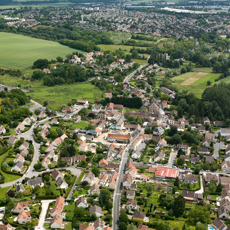
Location North aera of the Paris basin (95470) - Fosses
Population City 10,000 inhab.
Strategic site 126 ha - Project site 8.6 ha
Site proposed by City of Fosses with those partners on the project : Communauté d’Agglomération et ville de Fosses, PNR-OPF, CC Pays de France, CG95, DRAC, JPGF
Owner(s) of the site Ville de Fosses et propriétaires privés
Commission after competition Urban design project liable to lead to urban project management, redesign of public spaces, architectural project management in connection with partners
More Information
How can the site contribute to the adaptable city?
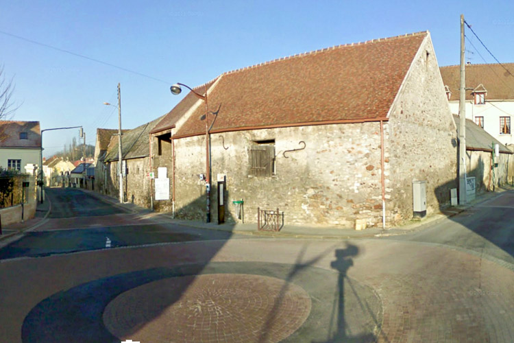
In the development zone within the wider Roissy area, the proposed site stands at the heart of the original rural village of Fosses. Its authentic village architecture corresponds to its status as an urban fringe on a farmland boundary. As a part of the town that is somewhat static and isolated, it needs to be revitalised without denaturing its particular qualities. The project raises questions at different scales. At the territorial scale, the remit is to respond to the exemplary nature of an operation that stands at the interface between the natural landscape and the urban environment; to imagine it as a stage in a regional network of processes linking different towns. At town scale, the remit is to think about establishing a dynamic that can give the village a new identity. At site scale, it is about exploring the proximities and dialogues between the contemporary character of the project and the nature of the historic centre with its archaeological legacy. This site offers an opportunity:
- to design a new housing district in a neighbourhood distinctive for its part urban, part rural status,
- to generate dialogue and harmony in the relation between the existing fabric and a new and exemplary project,
- to develop ideas about the nature of the links and the spatiality of the loci generated by public space,
- to devise buildings that support and changes that reflect the refurbishments that characterise the project site,
- to think about practices and spatial developments within a timeframe commensurate with the changes, and which promote social bonds by encouraging mixity and shared uses and by appealing to different populations.
City strategy
Four major objectives embody the municipality’s priorities in seeking to highlight and enhance the values of this area. In order to fulfil these objectives, the teams are asked:
1- To match the urban renovation programme underway on Fosses town centre and station hub, by drawing on the village’s historical and natural legacy to develop a project of urban regeneration and economic revitalisation that creates a new focal point at the heart of the old centre, the only part of the town that falls within the Oise Pays de France Regional National Park,
2- To make the village of Fosses a centre of cultural and ecological attraction, at the crossroads of a historical and natural route that extends along the whole Ysieux Valley: A Pottery History Centre, artist’s workshop combined with a gîte and bed-and-breakfast accommodation, promotional zone for the valley and its landscape, walking and cycling tracks…
3- To promote the development of sustainable economic activities by taking advantage of the proximity of the municipal technical centre (CTM) and the farmland bordering the site: sale of sustainable agricultural products, craft centre and locus of CTM related activities, etc.
4- To increase the range and quality of housing in the area, by developing innovative and appropriate programmes that meet the needs of different populations at different stages of the residential cycle: social and first-time buyer housing, designed for young adults and families.
Site definition
A member of Roissy Porte de France Intermunicipal District, the town of Fosses is located at the edge of the built-up area around Paris, in the Grand Roissy development zone and within the immediate sphere of influence of Paris/CDG airport.
Its location, its specific geography, its stretched urban layout, make it a gateway and connection between town and country.
At the heart of the old village, away from the recent town, the project site retains a character that calls for regeneration.
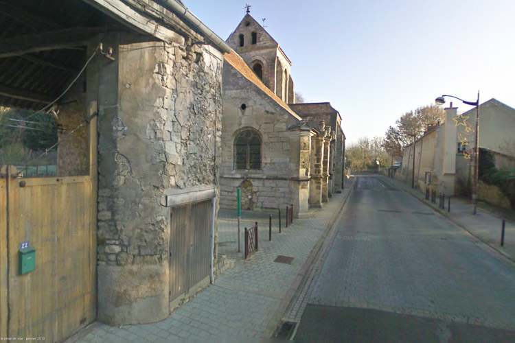
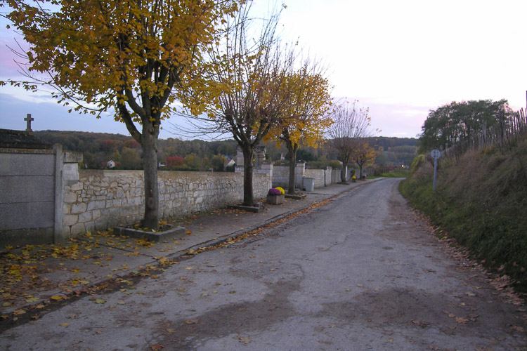
Bounded to the South by the main road running along the route of the Ysieux River, the town extends to the North upwards along Rue de la Mairie as far as the cemetery, which stands at the edge of the countryside. A housing estate and old farmhouses to the West and a range of properties to the East form the town limits and development boundaries. Along Rue de la Prairie de Rocourt and the high Street, the Church, alongside the “Centre for the interpretation of the Ysieux Valley’s ceramic heritage” and old farmhouses, function as landmarks and focal points for the new neighbourhood. The plots currently occupied by various municipal services and institutional buildings offer potential for conversion.
Adaptability : main elements to take into account
Several working themes provide the basis for possible responses.
- A transit neighbourhood: the aim here is to articulate the movement from the urban centre to the countryside, to weave a network of roads that qualify the public space and generate continuity, accessibility, permeability and traversability, creating a link via the countryside to the other part of the town.
- A neighbourhood conceived over time: To incorporate the time factor, projects should take an experimental approach to successive phases of implementation in the development of public space, and in the construction or refurbishment of buildings. Establishing stable prospects means accepting morphological changes, programmatic alterations, temporary activities and even a degree of reversibility, in order to take a relevant approach to the urban quality of the spaces and the form of the buildings.
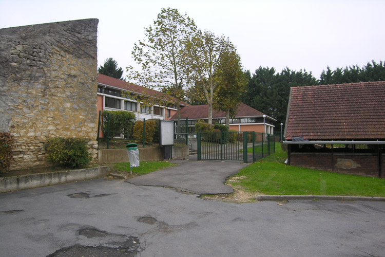
- A neighbourhood of diverse activities and practices: The plots within the project area are currently occupied by a number of municipal amenities and services, and by housing. Possible conversions based, for example, on a new approach to the role and management of the technical services, should contribute to proposals exploring the relation between housing and work, housing and schools, shops, economic activity, and more generally shared uses and a mix of programmes on the site. There are also opportunities to be exploited in the presence of cultural and religious spaces.
- An experimental modern district: As a newly devised reflexive interface between town and nature, consonant with a sustainable landscape, the objective here should be to experiment with the morphology of a new urban focal point, sensitive to the existing context, which raises the question of density and permeability, and weaves organic links between housing, amenities, activities and culture.
There is thus a unique opportunity here to create a new, contemporary, central urban space that will forge an organic link between town and country and, in terms of quality of life, meet the needs of the population.
On the strategic scale, the teams will be expected to develop proposals based on guidelines that reflect possible short-term and long-term changes and transformations, to stratify and interweave the themes developed within the framework of a contextual analysis that explains the development of the project ideas.
At site scale, they are asked to propose urban and architectural schemes which, within reasoned timescales, provide a framework for the practical implementation of an explicit operational programme. For the purpose of contextual harmony, the aim is to contribute to a strong sense of community, with comfortable exchanges and flows; to highlight the archaeological, historical and agricultural richness of the area; to model the solids and voids, the landscape of an equitable neighbourhood, where people will take pleasure in moving around, living, working and learning.
Questions on the site
Où pouvons-nous trouver les annexes du document FOSSES-FR-SS-M13, indiquées page p12?
no availables documents
Est-il possible d'avoir un plan topographique inforamtisé (dwg, dxf) avec des points de niveaux du site ?
FOSSES-FR-SS-M14
pdf + dwg
Quelle est l'échelle du document FOSSES-FR-SS-M01.pdf ?
dwg, no scale
Lors de la visite, il a été question d'un relevé topographique. Il ne semble pas être disponible sur la plateforme de téléchargement d''en est il ?
maps availables
Pourrions nous obtenir le plan DWG correspondant au Sud du territoire de réflexion?
all maps on the complete file site
Le plan dwg fourni n'est pas très détaillé. Est il possible d'avoir un plan avec le dessin du sol et la topographie qui sont essentiels sur un tel site?
all informations are given now
Existe-t-il et si tel est le cas, est-il possible d'avoir un relevé des fermes existantes ?
all informations are given now
Est il possible d'avoir des documents (plans, même sommaires) des édifices potentiellement réhabilitables (fermes etc.) ?
see updated maps
Can the zone indicated as "currently in the process of being acquired" be considered as non-buildable? And/or a private parcel?
already answered
see sitefile
Can the extension of the graveyard to 2.1ha on the project site be changed?
You can optionally suggest a variant in terms of drawing, specifying a specific landscape in connection with all of your suggestions but the extension is confirmed, as is the necessary surface.
Dans les parcelles en cours d'acquisition par la Commune, indiqués dans le document descriptif FOSSES-FR-T-Pr (page 67) comme prairie, entre 6.200 et 6.700 m², faut-il ou est-il possible prévoir des logements ou bien seulement des espaces publiques liés aux logements pour accueillir des manifestations, etc.?
The two programs are considered, knowing that the parcel is currently classified, which will mean a revision of the PLU; the text on p67 gives a better precision on that point.
CTM+Cité artisanale 1. En termes de surfaces, faut –il respecter les surfaces proposées ? 2. Afin de reloger le programme actuel de CTM et d’ajouter le programme de Cité artisanale, faut-il penser à proposer dans les parcelles occupés actuellement (parcelle n° 127,142, 162) ? 3. Peut-on avoir quelques informations en plus concernant au vestige des fours ? plans +coupes détaillés par exemple… Logement 1. Faut-il respecter PLU (hauteur de logement par exemple.) ?
europan is ideas compretition with suggested indications, in the file site spirit
Est-il possible d'avoir un plan topographique sous format autocad ?
FOSSES-FR-SS-M14
pdf + dwg.
Dans les parcelles en cours d'acquisition par la commune, si l'on peut construire les logements concernés aux surfaces entre 6 200m² et 6 700m², on voudrais savoir la condition de constructibilité. ( Par exemple, la limite des hauteurs et COS etc... )
ideas competitions, no limit, see files site's philosophy
Est-il possible d'obtenir des données topographiques plus précises que les données IGN sur l'emprise du site de projet?
FOSSES-FR-SS-M14
Le périmètre du site de projet diffère selon les documents. Pouvez-vous préciser si les parcelles pavillonnaires à l'angle des rues du Château et de la Mairie sont intégrées au site de projet : cd. 123 - 125 - 126 - 127 - 128 - 129 ?
we have no infomation about perimeter mistakes
Avons-nous tout le contenu à jour du Powerpoint diffusé lors de la rencontre du 4 avril 2013, comme précise le compte rendu?
yes
Selon le Compte rendu de la réunion du 4 avril 2013, il y aurait des "Documents complémentaires transmis aux équipes" : 1. Powerpoint de la conférence 2. Plan topographique de l'ensemble du site 3. Relevé complémentaire des bâtiments de la ferme 4. Plan de possibilités et contraintes d'intervention sur le périmètre du site (révisé avec l'ABF). Il semble que les documents n°1 et n°4 n'ont toujours pas été mis en ligne. Serait-il possible de les avoir?
see updated maps
Y a-t-il déjà un projet sur le centre d'interprétation de l'histoire de la poterie et sur son parcours muséographique, à intégrer dans le projet ? Si oui, serait-il possible d'avoir des précisions (pièces graphiques) sur ces éléments?
all informations are included in the filesite
Bonjour, Les coulées de boues ont elles toujours existé sur ce site ou sont elles apparues il y a peu? d'autres communes limitrophes sont elles touchées? Ou est ce un problème local? Y a t'il d'autres coulées de boues signalé à d'autres endroit de la commune? et si oui pouvez vous nous indiquer ou? Merci de votre attention. Cordialement JR
no information
Serait-il possible d'avoir une carte topographique du site de réflexion, en plus de celle du site du projet déjà fournie ?
no
Le compte rendu de la visite du 4 avril 2013 précise un certain nombre de "documents complémentaires transmis aux équipes". Or, nous n'avons toujours pas la totalité de ces documents, notamment le "Plan des possibilités et contraintes d'intervention sur le périmètre du site, révisé par l'ABF". Serait-il possible de mettre en lignes les documents manquants le plus rapidement possible? Ce document est primordial pour le développement du projet. On voit également sur la vidéo de la présentation faite par le Maire, une version de ce document qui paraît plus complète.
documents are updated
Sur le plan FOSSES-FR-SS-M14.dwg, dans la parcelle près du croisement des rues : Grande rue / rue de la Mairie, on voit l'emplacement des éléments comme : Vestiges de construction, Ruines et Puits. Ces éléments doivent-il être conservés?
see update map FOSSES-FR-PS-M14
- Le programme de "Cité Artisanale" évoque une dizaine d'ateliers de 100 à 120 m² (FOSSES-FR-T-Pr.pdf, page 68), à prévoir "en plus" de ceux du CTM et des ateliers municipaux existants. La surface de 750 m² prévue pour les ateliers comprend-elle également ces ateliers ou concerne-t-elle uniquement les besoins des services techniques municipaux?
this is clearly notified
Quelle est la densité actuelle du centre bourg et du nouveau centre de Fosses?
in the site file
Quelle est le type de pierre utilisée dans la construction locale? Est ce du calcaire lutécien?
we don't know
Etant donnée la présence de poterie et par conséquent d'argile dans la région, où se trouvait la carriere d'approvisionnement? existait il une briqueterie à proximité ou des constructions en terre crue?
no particulmar information about this purpose, but on the website of the archeology museum
Est il possible de savoir où vivent les personnes travaillants pour les services techniques, l'école et la mairie?
no information
L'église est elle classée et existe-t'il un périmètre de protection?
yes
Est il possible de préciser les dates du Moyen age concernant le village d'origine?
we don't know
Mis a part la poterie et l'apparition tardive de l'aéroport de Roissy quelle est l'histoire industrielle de Fosses de 2 derniers siecles engendrant une croissance de la ville de 200 à 10000 personnes?
this question is notified in the sitefile
Nayant pas de diagnostic précis concernant l'état de la ferme Letourneur et de la salle Delambre et bien qu'il soit écrit que ces bâtiments "paraissent de nature à supporter des réhabilitations lourdes et soignés" est-il possible de savoir si les habitations accolées à la salle Delambre jouent un rôle structurel et si les planchers de la ferme sont en bon état.
these technical informations are not necessary for this idea competition.
This site is connected to the following theme
The contemporary city aims to anticipate the future and adapt to its unpredictable changes. Various strategies are currently being developed to achieve a creative resilience, in other words adapt to a changing environment. Working on Ecorhythms means basing urban development on a strong synergy between urban and natural environments in order to break with a principle of opposition that has separated city dwellers from natural realities and gradually undermined those realities.
This separation between the city-dweller and nature is not only spatial, but also temporal. Indeed, a landscape is not a pretty image but a living environment governed by cycles (seasons, day and night, tides, climate variations, flora and fauna) forces of growth, fast and slow movement, migration and transhumance, etc.
In contrast with modernist town planning, which reinforced a division between urban rhythms and nature, the remit – through the strong presence of landscape on the sites – is to encourage the introduction of operational processes based on the maintenance or regeneration of these Ecorhythms.
Specific documents
Questions on the site
You have to be connected –and therefore registered– to be able to ask a question.
Fr. 16 May 2025
Deadline for submitting questions
Fr. 30 May 2025
Deadline for answers
Before submitting a question, make sure it does not already appear in the FAQ.
Please ask questions on sites in the Sites section.
Please ask questions on rules in the Rules section.
If your question does not receive any answer in 10 days, check the FAQ to make sure the answer does not appear under another label or email the secretariat concerned by the question (national secretariat for the sites, European secretariat for the rules).