Kaiserslautern
The Synthetic Site Folder and Site Brief are available for free.
Please register and login to access the Complete Site Folder.
- Synthetic site folder DE | EN
- Site on Google Maps
- Back to map
Data
Category urban - architectural
Team representative architect - urban planner - landscaper
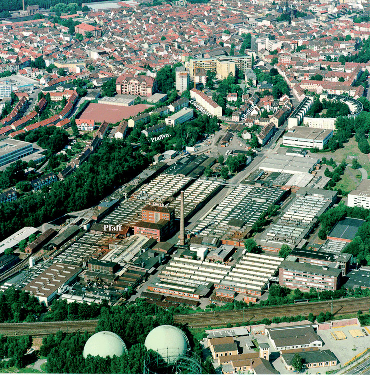
Location Kaiserslautern – Pfaff area
Population 98,100 inhabitants
Strategic site ± 30 ha - Site of project 21.7 ha
Site proposed by City of Kaiserslautern
Owners of the site Insolvency administrator
Commission after competition Urban master plan
More Information
How can the site contribute to the adaptable city?
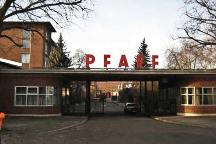
The first large industrial concerns in the Kaiserslautern area were established around 1850, favoured by the expansion of the railway network. With the founding of the Pfaff sewing machine factory in 1862 the city played an important economic role. The company has downsized from 9,000 employees in its hey-day to 250 employees today and was relocated to the fringe of the city in early 2010. The successive shrinkage has resulted in new uses in the neighbourhood, mainly aligned to purchasing markets. The relocation of the company has now given rise to the opportunity to initiate effective long-term development of the disused site in the context of transformation of the industrial city of Kaiserslautern to a knowledge- and technology-oriented centre with a global outlook.
City strategy
Based on the “CityTechnopole_Kaiserslautern” study, the plan area is to be developed as a “Technology Pole Pfaff Area”. Key contextual points for the development of the site are the Technical Univer-sity of Kaiserslautern to the south of the Pfaff site (with the adjoining Uni-Park and institutes located there), and the Westpfalz- Klinikum on the north-east side. An emphasis is to be given to the themes “Research, laboratories, services” and “Health, wellness and sport”. A vibrant urban mixed of uses is to be developed with the integration of residential uses. Soil contamination will necessitate a high level of soil sealing and vertical structuring with residential uses restricted to the upper storeys.
Site definition
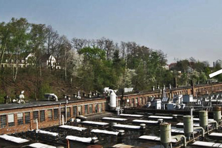
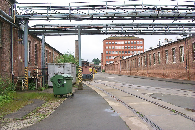
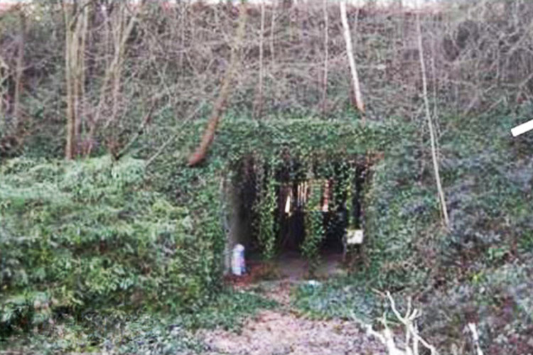
The plan area is located in the south-western part of Kaiserslautern city centre and only 1.5 km from the latter. The site is bounded by busy Königstraße on the south-east side and Herzog-von-Weimar-Straße (residential street) to the north. The railway lines form a boundary on the south-west side. On the north-east side the site is bounded by a Psychiatric Clinic, Albert-Schweitzer-Straße and Pfaffstraße. A former Pfaff housing estate adjoins the project area to the north and the ‘Crescent’ residential complex (listed buildings) to the east. With the exception of an administrative building and a boiler/turbine house, the existing structures on the former Pfaff site are deemed unsuitable for new uses.
Adaptability: main elements to take into account
The Europan Competition calls for proposals for extending the Science Mile from the Technical University via Uni-Park towards the city centre, with links to the Westpfalz Klinikum and the adjoining residential uses in the western part of the town centre. By virtue of the special significance of the site, priority should be given to the phased development of a technological centre. Strategies should be evolved for linking the institutes, laboratories and services with mixed urban uses. Temporary uses should be proposed and examined for their compatibility with the anticipated final uses. An attractive design of the main frontage to Königstraße should provide an impetus for the future development of the areas adjoining to the south.
Due to the retail uses already established here, it may be expedient to limit new retail floor space in the planning site.
The terrain edge on the north-west side of the planning area offers opportunities for a green margin or exclusive residential units on the slope. Demolition waste and excavated earth could be used for screening the site against the railway lines in the south-west or for central parking facilities. The need to provide a water storage basin should be satisfied with a landscaping design that enhances the amenity value of the site. The urban planning uses should be reconciled with the soil remediation concept.
Questions on the site
Do you know if it's possible to visit the Pfaff-area in Kaiserslautern on a day other than May 3rd? We would like to visit the site on April 20th, but we don't know if there is a fence or entrance gate or something.
It is possible to visit the Pfaff-area also on 19 April 2013, meeting point at 9.00 a.m. at the main entrance of the Pfaff area, Königstrasse 154 - 67655 Kaiserslautern. Beyond the official visits it is not possible to enter the area. But you can have a good view over the area from the stop station in the West, from Albert-Schweitzer-Straase in the East and along Herzog-von-Weimar-Strasse from the North.
Why have the buildings marked as "only fit for demolition" in the documents have to be demolished? Couldn't some of them be renovated and converted? Weshalb müssen die Gebäude die in den Dokumenten als "Abrissreif" gekennzeichnet sind abgerissen werden? Könnten manche dieser Gebäude eventuell doch umgenutzt und renoviert werden?
The demolition is required due to the condition of the buildings, the contamination of the materials and the non-qualification for the "Technology Park"-uses. Nevertheless, the existing buildings could be used for temporary uses where possible in the intermediate phases of an anticipated long-time development.
Der Zustand und die Belastung der Baumaterialen machen ebenso wie eine fehlende Eignung für die Nutzung als Technologiepark einen Abriss erforderlich. Da jedoch eine zeitlich gestreckte Realisierung erwartet wird und Zwischennutzungen vorstellbar / sinnvoll sind, können die vorhandenen Baustrukturen für die Zwischenphasen berücksichtigt werden.
Welchen Typ von Altlasten findet man auf dem Wettbewerbsgebiet? Handelt es sich um Verschmutzungen durch Gas, Metalle, etc?
Durch die langjährige industrielle Nutzung sind umfangreiche und unterschiedliche Boden- und Grundwasserbelastungen vorhanden, die eine grundlegende und flächige Bodensanierung (Bodenaustausch) des gesamten Wettbewerbsgebiets erforderlich macht.
Eine differenzierte Betrachtung einzelner Belastungen ist im Rahmen des Wettbewerbs nicht leistbar. Die sehr umfangreichen Bestandsuntersuchungen und die Sanierungsvorplanung wurden daher nicht als Informationsmaterial bereitgestellt.
Durch eine Technologienutzung können hohe Versiegelungsgrade erreicht werden, die eine künftige Grundwassersanierung (Laufzeit ca. 30 Jahre) begünstigen.
Die Ergebnisse der Sanierungsvorplanung begünstigen für eine Berücksichtigung von Wohnen hierbei die Standorte nach Osten zum Rundbau und dem Altenheim/der Psychiatrischen Klinik sowie die Flächen im Zentrum des Gebiets (Gebäude 20, 80, 22, 63, 44, 30 und 40) hin.
To what extent can the strategic site (outside the project site) be planned? Is it allowed to change or demolish existing buildings? In welchem Umfang kann im Betrachtungsraum (ausserhalb des Wettbewerbsgebietes) geplant werden? Dürfen bestehende Gebäude verändert oder abgerissen werden?
The housing area in the northern part of the project site are considered as stable and therefor considered as given. The commercial uses south of the project site / south of Königstrasse and along the Brandenburger Strasse can be replaced as a vision. Especially a planned vision for the situation along the Königstrasse would be interesting.
Die Wohnnutzungen im Norden des Wettbewerbsgebiets sind eher als stabile Nutzungen anzusehen und als Rahmenbedingungen zu betrachten. Demgegenüber stellen die angesiedelten Märkte südlich des Wettbewerbsgebiets bzw. südlich der Königstraße ebenso wie die Märkte an der Brandenburger Straße Nutzungen dar, die als Vision ersetzt werden könnten. Insbesondere eine planerische Reaktion auf die Situation entlang der Königstraße wäre hierbei interessant.
Is it possible to provide a cadaster plan of the whole strategic site ? Wäre es möglich einen Kadasterplan mit dem kompletten Betrachtungsraum im dwg-format zur Verfügung zu stellen?
Yes, the plan will be provided.
Ja, die Daten werden ergänzend zur Verfügung gestellt.
Do you have more information concerning the pollution that we have to deal with within the pfaff area ? And should we keep more building that what is planned ?
Due to the long-time industrial use there are different extensive ground- and groundwater-contamination which require a complete and planar soil rehabilitation in the whole project area.
A differentiated view on single contaminations is not possible in this comeptition. The voluminously large analysis of the existing buildings and the preliminary planning for the rehabilitation are not provided as information material.
A technology-use can provide a high level of ground-sealing and therefor promote a future groundwater-rehabilitation (which last about 30 years).
The results of the preliminary planning for the soil rehabilitation promote housing uses the areas in the east to the "Rundbau" (rotunda), the home for the elderly/psychiatric clinic and the areas in the center of the project site (buildings 20, 80, 22 63, 44, 30 and 40).
Wann werden Sie einen dwg-Plan mit dem größeren Betrachtungsgebiet online stellen? (bitte Kennzeichnung angeben) Bei dem Kolloquium wurde gesagt, es würde uns ein grober Plan mit Kennzeichnungen der unterschiedlichen Belastungszonen des Planungsgebietes zur Verfügung gestellt. Wann wird dieser Plan online gestellt? (bitte Kennzeichnung angeben)
Der dwg-Plan mit dem größeren Betrachtungsgebiet ? (KAISERSLAUTERN-DE-SS-M2.dwg) steht im Ordner "New docs after launch" bereit. Ein Plan mit Kennzeichnungen der unterschiedlichen Belastungszonen des Planungsgebietes kann nicht zur Verfügung gestellt werden.
It would be very important to have more information about the soil contamination in this area: sometimes the ground sealing can be very dangerous and increase the water pollution. Why in this case is it recommended? Es wäre sehr wichtig, mehr Informationen über die Bodenkontamination zu bekommen: manchmal ist es gefährlich, den Boden zu versiegeln und damit das Grundwasser zu belasten. Warum wird es in diesem Fall empfohlen?
Due to the long-time industrial use there are soil contaminations which were washed out to groundwater levels. Therefore a groundwater remediation is carried out since several years. Different pumps are located in the area for this.
Through the demolition of contaminated buildings and the remediation of soil, the defined pollution should be minimized. Through ground sealing and intensive building development a further wash outof pollutants are reduced at the same time.
Aufgrund der langjährigen industriellen Nutzung des Geländes sind Bodenkontaminationen vorhanden, die in die Grundwasserstockwerke ausgewaschen wurden. Seit mehreren Jahren wird daher eine Grundwassersanierung betrieben. Auf dem Gelände sind hierzu verschiedene Pumpen installiert.
Durch den Rückbau belasteter Gebäude und die Sanierung der Böden soll künftig der Schadstoffeintrag minimiert werden. Gleichzeitig kann durch eine intensive Bebauung und Versiegelung eine weitere Ausschwemmung von Schadstoffen reduziert werden.
Is it possible to have informations about the existing buildings heights?
The buildings are available in a wireframe model in the folder new docs after launch (KAISERSLAUTERN-DE-PS-M13.skp). The model is based on 4 measuring points/m², so the dimensions are only approximate values.
What about the quality of the existing trees along the Herzog-von-Weimar-Straße ? Wie hochwertig ist der Baumbestand der oberen Geländekante entlang der Herzog-von-Weimar-Straße einzustufen?
The trees have no protection status. Nevertheless they are an important green structure that is not influenced by soil decontamination and could therefore be used as a puffer during the building phases.
Der Bestand hat keinen gesetzlichen Schutzstatus, stellt aber eine wichtige Grünstruktur dar, die nicht von Bodensanierungsmaßnahmen betroffen ist und somit auch während dem Realisierungsprozess mit Beräumung größerer Flächen einen wichtigen Puffer bilden kann.
Could you send a map with photopoints? Gibt es eine Karte, auf der die Aufnahmepunkte der Fotos verzeichnet sind?
Sorry, this is not possible.
Nein, leider nicht.
Could you send more boundary pictures? Können mehr Fotos des Betrachtungsraumes zur Verfügung gestellt werden?
There are several new pictures in the "new documents after launching"-fodler.
Es existieren mehrere neue Bilder im Order "new documents after launching".
Can we change/transform the southeast road junction? Können wir die südöstliche Kreuzungen verändern/transformieren?
The necessity for such a transformation and the costs is not seen at the moment.
Eine Notwendigkeit für eine solche Veränderung und die damit verbundenen Kosten wird bislang nicht gesehen.
Could you send more information(photos and plans) about heritage buildings? Können mehr Informationen (Fotos und Pläne) der Baudenkmäler zur Verfügung gestellt werden ?
There are several new pictures in the "new documents after launching"-fodler.
Es existieren mehrere neue Bilder im Order "new documents after launching".
Could you provide more information about the small lake?is it contaminated? Können Sie uns mehr Informationen zu dem kleinen See geben? Ist er kontaminiert?
There is no lake. If there is a puddle somewhere it should be contaminated and therefore remediated.
Ein See ist nicht bekannt. Sofern sich irgendwo eine kleine Pfütze gebildet hat, muss aber von einer Bodenbelastung ausgegangen werden, die zu sanieren ist.
Will the gas plant be moved? Wird das Gaskraftwerk verlegt?
If the gas plant is meant that is located west of the train tracks at the boundary to the Pfaff area: no.
Wenn mit der Frage das Gaswerk gemeint ist, das im Westen hinter der Bahn an das Pfaffgelände angrenzt, ist dies zu verneinen.
What is the present and future use of heritage buildings? Wie sieht die gegenwärtige und die künftige Nutzung der Baudenkmäler?
There is no formal declaration of heritage buildings. Some buildings have a potential for being protected. All the buildings are empty at the moment. Ideas for intermediate uses and reuses are explicitly desired.
Im Gebiet gibt es keine formelle Unterschutzstellung. Einige Gebäude haben aber das Potenzial zur Erhaltung. Derzeit ist der gesamte Gebäudebestand leer stehend. Ideen zur Zwischen- und Umnutzung sind ausdrücklich willkommen.
Is the project an opened or closed concept?
The project should open up the area to the inner city as well as to the University campus – but maybe this was not your question?
Could we make use of the structure/roof of building 9? Is there any possibility to rehabilitate this building 9 or should it be demolished? (KAISERSLAUTERN-DE-PS-P2 .jpg Situationsfoto - Geb 9 innen nW) Können wir die Konstruktion des Gebäudes 9 nutzen ? Gibt es eine Möglichkeit, dieses Gebäude zu erhalten oder soll es abgerissen werden ? (KAISERSLAUTERN-DE-PS-P2 .jpg Situationsfoto - Geb 9 innen nW)
Good ideas for a new use are welcome. The structure can be used for that.
Gute Ideen für eine Nachnutzung sind willkommen. Dabei kann der bauliche Bestand auch aufgegriffen werden.
Could you provide some more images of the interior of the warehouses, other than KAISERSLAUTERN-DE-PS-P2? Could you also provide a higher resolution version of KAISERSLAUTERN-DE-PS-AP2 ?
There is no higher resolution version of KAISERSLAUTERN-DE-PS-AP2. But there are several other new pictures in the "new documents after launching" folder.
It is possible to facilitate graphic information (photos, elevations, etc.) about buldings nummber 13, 14, 18, 19, 60 and 77 of the map KAISERSLAUTERN-DE-PS-M8?
You will find additional photos in the "New_docs_after_launch" folder (KAISERSLAUTERN-DE-PS-buildingXX.pdf) and also a wireframe model (KAISERSLAUTERN-DE-PS-M13.skp).
On page 27 of the text Kaiserslautern-DE-C-Pr it is said: "The planning area has a size of around 19.5 hectares." The percentage of net construction surfaces in the area should be at least 60%. A site occupancy index of a maximum of 0.6 is assumed. Does it mean that 11.7 hectares must be built?
Yes, although the value is only a benchmark.
Program - surfaces : it is asked to build about 275,000 sq meters as gross floor. The given uses (science, residential, shops, parking) totalise 86%. What should be done with the remaining 14%? Are these 275,000 sq m given for inside the red perimeter or inside the yellow perimeter?
The surfaces should be bivided as follows: 50% science, research and technology, 25% residential, 15% gastronomy/shops, 10 % parking. The surface of 270.000 m2 is inside the red perimeter.
Freiraumstrukturen - We understand that we have to keep as much trees and existing greeneries as possible; but on the other hand we have to limit the outer spaces to very primar, minimal uses; and also that we must extend the sealing of the ground to the whole Pfaff area in order to avoid groundwater contamination. How can both be combined?
Setting focal points is part of the competition task.
Should the existing programms along Königstrasse (shops, supermarkets, parking lots…) be reintegrated in the new masterplan in the same quantity as they are now? Sollen die bestehenden Nutzungen entlang der Königstraße (Läden, Supermärkte, Parkplätze...) in den neuen Masterplan im gleichen Maße, wie heute, integriert werden ?
The presentation of the existing supplies is not necessary. Approaches to revaluate the urban fabric are desired and can be displayed.
Die Darstellung des heutigen Bestands ist nicht notwendig. Planerische Ansätze zur städtebaulichen Aufwertung sind jedoch erwünscht und als solche darzustellen.
This site is connected to the following theme
From Mono-Large to Multi-Mix Sites are undergoing two kinds of closely related transformation: the first from a single large entity to a multitude of smaller parts; the other from a mono-functional entity to a mix of functions and uses.
Both transformations generate a greater degree of spatial and programmatical complexity, which is an essential quality of genuine urbanity.
In these transformations a system composed of smaller, separate and different elements is potentially more adaptable. If one part becomes redundant, it can await change or replacement without too great an impact on an area. If new needs arise, these can be more smoothly absorbed into a differentiated pattern of distribution. A fine urban mix is more adaptable than a large mono-functional cluster.
Questions on the site
You have to be connected –and therefore registered– to be able to ask a question.
Fr. 16 May 2025
Deadline for submitting questions
Fr. 30 May 2025
Deadline for answers
Before submitting a question, make sure it does not already appear in the FAQ.
Please ask questions on sites in the Sites section.
Please ask questions on rules in the Rules section.
If your question does not receive any answer in 10 days, check the FAQ to make sure the answer does not appear under another label or email the secretariat concerned by the question (national secretariat for the sites, European secretariat for the rules).