København
The Synthetic Site Folder and Site Brief are available for free.
Please register and login to access the Complete Site Folder.
- Synthetic site folder DA | EN
- Site on Google Maps
- Back to map
Data
Category urban - architectural
Team representative architect
Location Copenhagen
Population City 561,000 inhab. - Conurbation 1,213,822 inhab.
Strategic site 8.75 ha - Project site 3.75 ha
Site proposed by Municipality of Copenhagen
Owner of the site Municipality and housing associations
Commission after competition Depending on the competition entries received, the City of Copenhagen intends to offer the winner of the competition the chance to act as a consultant in the development of the site and possible sub-projects in energy renovation and climate adaption in the selected strategic site and focus areas.
More Information
How can the site contribute to the adaptable city?
Seen in light of the challenges facing the city, Copenhagen Municipality sees great potential in «the adaptable city».
Large cities are growing and growing - more people are moving to urban areas, and those who already live here are staying put. Combined with the growing consciousness on increasing climate changes and world’s resources, this has resulted in a wish both from the politicians responsible and the individual citizens to develop and transform the city into a flexible and living/modifiable organism, which can adapt to changing needs and wishes for ways to live and to use the city.
City strategy
In tandem with the focus on and great consciousness about climate problems and consumption of resources, more and more countries are drawing up policies and guidelines for sustainable development. In The City of Copenhagen there has been an increased awareness of these areas, as well as of the necessity for adaptation and resilience in the pre-existing city. This should be seen in connection with an awareness of the architectural challenges involved in renovating the existing housing mass to meet new energy standards. Politicians in the City of Copenhagen are taking regular initiatives to accomodate these challenges.
Copenhagen has been awarded the EU-Commission’s prize of being Europe’s Green Capital in 2014. This should be seen as recognition of the efforts to create a green and environmentally sustainable city, which is good both to live and invest in.
Site definition
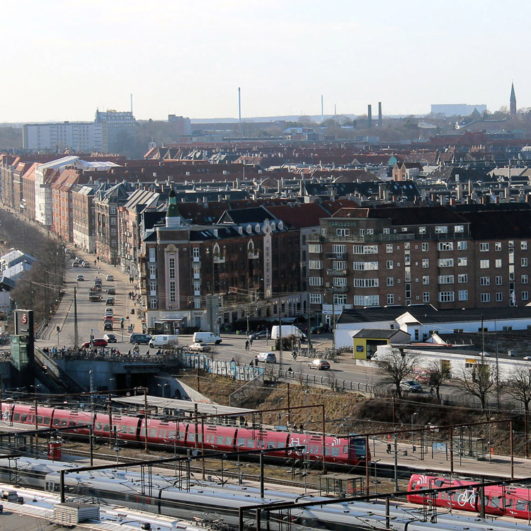
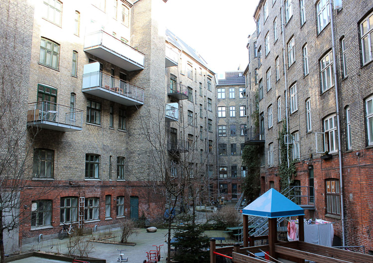
Copenhagen is located in eastern Denmark facing the Baltic Sea and Sweden. Vesterbro is in the south-western part of Copenhagen, close to the harbour.
Copenhagen has a population of around 561,000, a figure that has been increasing over the past few years by around 1000 new residents per month. In Vesterbro, the population is around 36,000.
Vesterbro is located west of the old medieval city and bordered to the south by the railway; to the west by Søndermarken park; to the north by Frederiksberg municipality and to the east by the medieval city (inner city).
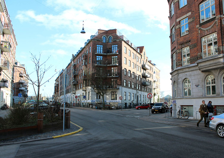
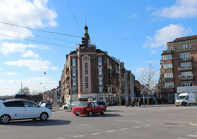
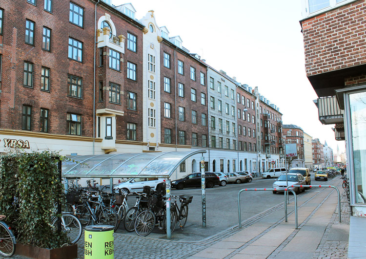
Vesterbro is a densely built area, with narrow yards where back buildings once stood, both for residential and business purposes. Today, many of these back houses have disappeared and in the competition area it is only the blocks on Skelbækgade, Sdr. Boulevard, Sommerstedsgade and Ingerslevsgade, where there can still be found businesses and garages around the back.
Adaptability: main elements to take into account
The future’s inheritance.
The densely built-up city requires fresh ideas, not only in regards to climate change but also in terms of optimizing energy.
The buildings in the project area represent Copenhagen’s identity and cultural heritage. They have shown their strength and robustness over time, and with good solutions and smart decisions when it comes to energy optimization and climate adaptation, which means finding the right balance between transformation and preservation, these old buildings can retain their identity and still be future safe; and in this way, strengthen the area’s ability to adapt itself to coming changes and crises.
The size of the houses means that many families today feel compelled to move out of the area. Thus we need fresh ideas on how to develop housing and ways to live, and there is a desired focus for alternative solutions to the simple merging of apartments, e.g. with extensions out into the street, courtyard and up into the rooftop.
Solutions are sought on all levels, from the simple housing unit to the entire area, from low-tech to high-tech solutions; likewise, levels in the kind of upgrades housing requires ranges from tight to ample economies, and from individual solutions to shared solutions across buildings, courtyards and streets.
Multifunctional and scalable solutions are required in densely built-up urban areas with sparse housing and recreational space. These kind of solutions for built-up urban areas can be applied to other parts of Copenhagen, Europe and the world.
Questions on the site
After downloading the complete København site folder we noticed that 'Koebenhavn-DK-C-M1.DXF' file has its two refence files missing. Can you upload those files ("TEKNISK_UTM.DWG", "MATRIKEL_UTM.DWG") on the website?
New files has been uploaded on the website - these should include all the information.
After downloading the complete København site folder, we noticed the competition document are a rather rough description of the study area. We understand the building is owned by private people, making detailed information difficult to get; we also understand we are not asked to produce a coherent architectural project; however we feel that having a complete floor plan, and a complete groundfloor plan is the least we need to produce a work meeting the expected demand. Are you planning to upload more detailed documents about the building itself?
More detailed material has been uploaded for the site of Copenhagen - we hope this is what you felt you needed. Please find this material under in the site folder.
You mention the "retail area" as one space the proposal should take into consideration. Is this referring to the meet market district which is outside the study area or is it dybbolsgade, the main commercial street? If this is referring to the meet market district, can you precise whether this area should be part of the proposal or not?
Unfortunately there has been a spelling mistake - the 'retail area' is suppose to be the 'detail area'. This refers to the building in the project site meaning that the participants has to show the connection between the building and the surroundings.
To what extend can we change the form of the views of the buildings? What are the rules and the laws that we must follow?
As mentioned in the program for the site the properties on the project site has a high to medium conservation value. There are no specific rules on what is permitted, but measures must respect the architecture of the building and the specificity of the area. Generally there is very little restriction on the court yard.
Could you please explain us what the 'Presentation values' are? Do they affect the range of interference that we will propose on the views of the buildings?
Taking that you mean 'preservations value' the following links can be of help to you:
http://www.kulturstyrelsen.dk/english/cultural-heritage/listed-buildings/buildings-worthy-of-preservation/
http://www.sns.dk/byer-byg/Netpub/INTRSAVE/TEKST/CONTENTS.HTM
How high is the groundwater level in the area?
In most of the project site and study site the terrain-water table is over 3 meters (see the map newly added document on the Europan-Europe.eu)
Can/Should the apartments in the project site building be merged?
Not necessarily. Over the past years, our consumption of m2 has increased - we could ask ourself if that is the path we want to continue following?
Should we design the building on the project site for only large families?
No, it is important that there is a diversity within smaller units as well. You could bear in mind the possibilities of flexible areas.
Should all the mentioned challenges be solved in the proposal?
It is not expected that you solve all the challenges in your proposal, but it is expected that you give an scheme/vision for the whole area, plus large and/or small ideas/visions that can be used on the specific site and in parts of the rest of the city.
Why is the building block on the project site selected?
It is a distinctive residential property from the turn of the century as there are many of in Copenhagen and has three very different sides. The sites are facing the narrow Krusågade, the facade with shops on Dybbølsgade and the significant site facing the railway terrain, where the building are being a strong and highly visible architectural element in the surroundings.
Have the residents been involved in the project?
No, the municipality of Copenhagen have not had a close dialogue with the residents, but one of the properties has applied for renewal support and the municipality have had contact with the others regarding sustainable initiatives in general.
(Have a look at the map: København-DK-PS-M4)
We noticed each housing unit can be reached by two staircases. Is this a matter of security, are both those staircases in use or is this something inherited from past uses?
The reason why there are two staircases for safety reasosns in case of a fire, as both staircases are made of wood. If there are to be only one stair this one should be secured against fire for example with water sprinkling.
After downloading and checking all the data you have made available, we have noticed that only one general plan regarding one of the floors are given. Are the other floors the same? Do they change from one floor to another? Will you upload more plans of the other floors?
All the floor plans are the same, and do not change from one floor to another. There will therefore not be uploaded any more plans of the other floors.
Will you upload the facade of block 35, Krusagade, since it is missing in the available files?
New facedrawing has been uploaded (Koebenhavn-DK-PS-M28.pdf).
What should be shown in the "1:2000 situation plan"?considering that, from above, the changes of the building won't be that visible in scale 1:2000, which particular aspects should to be highlighted?
I could show the principal and the general idea behind the solution.
Could you please explain the point 3. of the "competition proposal"?
An example could be, to create an social facility in the building/courtyard/street that makes it possible for more people to meet up and thereby create a new social network.
After a hypotetical computation of the people living in the blocks, should the proposal mantain it or can change it?
Yes, it's okay to change the number of people living in the block
Can the m2 of the apartments be changed?
Yes, it can
Is it possible to know how many people live in the project block?
Not precisely. In general each person in Copenhagen has about 41,6 m2 (2012) per person, but it might be a little lower when it comes to this part of Copenhagen.
Checking the uploaded pdfs (København-DK-PS-M25; København-DK-PS-M5,6,7,8; København-DK-PS-M9,10,11,12) and the pictures of the facades, we noticed that they don't match. Wich ones are the right?
The facade from Dybbølsgade (Kobenhavn_DK-PS24) and the real building does not match completely. The original drawings and pictures are showing the house today - is means that there has been changes made just before the house has been builded or after that. When it comes to the facade drawings (Dybbølsgade) Kobenhavn-DK-PS23 is there a overlap with the drawing Kobenhavn-DK-PS22, which is why it seams longer than it is - this is to be seen on the old writing on top of the paper. in Ingerslevsgade the facade-drawings (Koebenhavn-DK-PS-M16 is the original, but there has been changes made around the balconies. There are no pictures that show’s this. Uploaded is a newer facade drawing (Koebenhavn-DK-PS-M29), but there is no updated version for the rest of the facade with new balconies. When it comes to the cutting thought Th.e building it’s should be taken as a principal since it’s not possible to be find the precise spot where the drawing was made in the 100 years old drawing.
Is it possible to know the dimensions and the materials of the buildings walls?
The outer walls and bearing walls is made out of bricks. The thickness is 240 mm plus plaster/wood lagging which means that the total thickness is approx. 300mm.
Should the number of the new apartments design be the same amount or can they be less or more?
There can be more or less - this is up to the team.
After having looked at all the maps provided, I don't seem to be able to find one that has the heights/levels - are they on any of the maps or would it be possible to get a map of the levels (there seems to be a difference in level between the street and the courtyard and possibly also within the courtyard itself ?
There is a map with the different levels in the area - check out the map Koebenhavn-DK-PS-M27.
We need more technical drawings about the ground floor, and basement floor where we can se entrances to the courtyard, basements, shops, etc. Would you upload more drawings, schemes or text about it?
Floorplans of the basement and ground floor has been uploaded.
Can the height of the building project be changed? is there any restriction?
As a basic principles the height of the building can be changed.
Would it be possible to have more information about the work that Dybbølsgade Street Guild is currently doing at the site?
For more detailed information on the Street Guild - please check the the site seeing report.
The facade towards Ingerslevsgade differes in the competition material fro the current exterior look, especially concerning Ingerslevsgade 104 - 108. is it possible to have these drawings updated? or is it deemed insignifigant for the scale of the delivery?
SInce there has been smaller changes made to the building and these are not registred in the general data base these can be considered as not being of importants to the general idea of the building project.
With all our changes to ex existing appartments, urban spaces, building envelopes etc how much will cost be a factor? Is there a budget or is it deemed this is only a catalouge where some options may be incorporated - I guess the overall question is how is realisability and visionarity individually graded?
No precise grade is made on the realisability and visionarity, and the municipality would like like projects including both.
Required drawings: 'Visualisation of Ingerslevsgade as seen from Dybbølsbro: see photo' -Which photo do you refer to?
The photo that is refered to is Koebenhavn-DK-PS-AP2.jpg.
in concern to the dimensions of the structure, the uploaded drawings show an app. wall thickness of 500 mm in general - is this then not accurate ?
For constructional resons the wall often varies, so that it is thicker on the ground floor than the top floor. The municipality does not know whether the building is exactly built according to the drawing, but as a basic principal it's okay to take the measure 300 mm for all the walls in the building.
Although we note your response to an earlier question we feel it would be most useful to have access to a ground floor plan. We assume this differs to the repetative floor plans above as it shows access to retail units, basements and the courtyard. Hope you can upload something?
Floorplans of the basement and groundfloor has been uploaded.
There are two different kinds of ownership: 'co-operative housing association' and 'owner association'. Does it happen that co-operative housing associations sell their property to individuals (on a larger scale)?
Yes, but it does not happens often, and only if the 'co-operative housing association' has economicly difficulties.
In the '0-New_docs_after_launch' the document 'Koebenhavn-DK-C-Pr-EN' is uploaded. Does it mean that there are some additions or changes made? And if so, could you address which issues are added / changed?
There has been no additions or changes made - only a minor spellingmistake has been corrected.
What material(s) are the floors made of?
The floor consisting of a wooden construction and clay.
Is it the intention that the existing residents - house owners - will stay after the conversion?
yes
Can we assume that the percentage between privately owned tenants and housing co-operatives in the other blocks are equal as in the project site block?
Yes, it can be assumed.
Is there a restriction of expanding the plot of the building block towards the street?
Yes, there is restrictions, but the municipaliy is open for given a dispensation.
Is the ground of the courtyards polluted?
Yes, patchy areas of the ground in the courtyards is polluted.
Is it allowed to replace existing functions by others? or should we respect existing ownership/ rentals?
Yes, it is allowed to replace existing functions by others.
Are there floorplans available of the basement and ground floor? We don't believe that these floors will have the same layout and programme as the one as given.
The floorplan have now been uploaded.
Is the given floorplan up to date according to like the size of apartments, bathrooms, circulation, balconies, etc.
Yes, the given floorplans are updated.
Is the structure of the load bearing walls (bearing facades and central wall in between) for all blocks equal tot the project site?
It should be assumed that the structure og the load bearing the walls for all blocks are equal.
As we read from the text is the noise level unexpectedly high. Does this mean we should give a solution for this?
A solution on how to lower the noise level would be good, but it is obligatory.
About the documents to submit. Could you please give specification about the digital document to submit? What does it mean attached to the program? Is it considered additional information to the three A1 Panels? Could you please be specific about the final digital documents to submit? (format, digital resolution and so on)
It is not additional to what is said to be handed in according to the rules (http://www.europan-europe.eu/en/session/europan-12/rules/), but what kind of information the Municipality of Copenhagen would like to have to be able to judge the project.
You said that “in most of the project site and study site the terrain-water table is over 3 meters”, as it is shown in the map uploaded. We understand that floods can occur over this level on green areas and under this level on red areas, but what is the 3 meters line referred to (is it just a mesure of the water level, is it referred to the sea level, etc...).
The 3 meters line referes to the ground-water level.
We understand that in the plan Koebenhavn-DK-PS-M25 “Complete Original Floorplan” measurements or dimensions are in non-metric units. Could you tell us which would be the equivalet in the International Metric System for 6º and 5º191/2’’, for instance?
1 ” tomme = 2,54 cm, 10 alen = 62,77 cm
According to the information given in plan Koebenhavn-DK-PS-M27, regarding contour lines, we can observe that the backyard is located at 3 meters above sea level and streets around the buildings (Ingerslevsgade, Dybbolsgade y Krusagade) are always between 1,5 and 3 meters above the backyard level. However, in all sections (Koebenhavn-DK-PS-M9, Koebenhavn-DK-PS-M10, Koebenhavn-DK-PS-M11, Koebenhavn-DK-PS-M12) the backyard is always at the same level or even above the level of the streets. Could you give us some information about the real situation? At least, could you tell us what the backyard level is?
The correct conditions can be seen on the contour lines - Koebenhavn-DK-PS-M27.
Could you give us some information about the actual uses of the Basement and the lower Basement? Are there any apartment?
The basement and lower basement is not used as apartments, but is used by business, commercial lease and as storage for residents.
This site is connected to the following theme
Heritage of the Future Heritage is generally thought to look back to the past, but conversely it could be said that it should look to the future. Heritage is usually considered to be extraordinary, but is there not a case for thinking about the definition of “ordinary heritage”? Heritage is customarily perceived as an architectural object, but this office will explore ways to “create heritage” in three types of context where it is in principle lacking: the transformation of orphan districts, the conversion of neglected buildings or plots, the redevelopment of abandoned industrial zones or enclaves.
It can be hypothesised that the more the city, in both its morphology and its functions, spans, recaptures and expresses the eras and phases of its development, the more it develops its capacity to adapt to change, its potential for urban adaptation and its ability to resist sudden crises. So the question is: does creating heritage mean increasing the capacity to adapt the future city?
Questions on the site
You have to be connected –and therefore registered– to be able to ask a question.
Fr. 16 May 2025
Deadline for submitting questions
Fr. 30 May 2025
Deadline for answers
Before submitting a question, make sure it does not already appear in the FAQ.
Please ask questions on sites in the Sites section.
Please ask questions on rules in the Rules section.
If your question does not receive any answer in 10 days, check the FAQ to make sure the answer does not appear under another label or email the secretariat concerned by the question (national secretariat for the sites, European secretariat for the rules).