Rouen
The Synthetic Site Folder and Site Brief are available for free.
Please register and login to access the Complete Site Folder.
- Synthetic site folder EN | FR
- Site on Google Maps
- Back to map
Data
Category Urban - architectural
Team representative architect - urban planner - landscaper
Location city of Rouen
Population City 113,500 inhab. - Conurbation 486,200 inhab.
Strategic site 111 ha - Project site : 35 ha
Site proposed by City of Rouen, with those partners on the project : RFF - SNCF
Owner(s) of the site City of Rouen, RFF - SNCF, State (waterways et main roads)
Commission after competition Urban design project liable to lead to urban project management, redesign of public spaces, urban scenography, architectural project management introduce by partners (civil engineering)
More Information
How can the site contribute to the adaptable city?
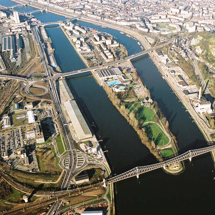
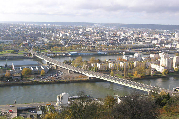
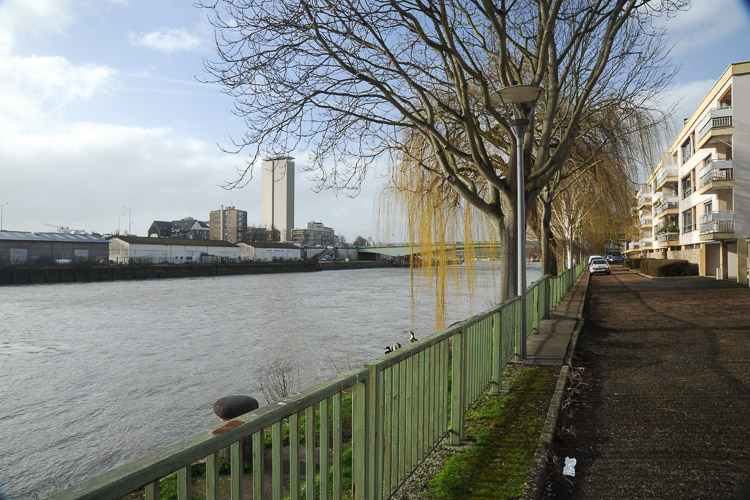
The proposed site encompasses an area around the Seine to the east of the city centre. It runs from the St-Sever railway brown field site (future left bank station) to Île Lacroix. Though both major urban landmarks, there are few connections between the two. The purpose of the project is to provide coherent proposals for the development and integration of the embankments, through their respective changes. Establishing the terms for a profound transformation of this area means thinking about future uses, links and connections, a diversity of alternative practices, which will contribute to a future sustainable city.
Over the next 15 years or so, there needs to be reciprocal adaptation between the station and the Island, a built-up and inhabited space with remodelled boundaries. For an urban whole to emerge from these distinct territories, with the river as its common denominator and its banks as a unifying factor, requires a long-term approach that anticipates project changes, reflection on the rhythms of change, and an adaptation of current and future uses.
Proposals will need to respond to urban divisions in the dense city by establishing crossings, continuities, permeabilities, and devising infrastructures that will guarantee high quality public space.
For the city centre location, using the Seine as a source of opportunity, projects will need to propose urban and architectural forms imbued with the presence of nature and biodiversity.
The compatibility of uses with the desired urban quality, their sustainability, the experimental nature of temporary events, changes, juxtapositions in time, will need to be explored right through to the end of the process of transformation of the site and help to tackle the challenge it raises.
City strategy
Geographical coherence makes the banks of the Seine an essential guiding thread in the transformation of the city centre. More broadly, these ideas of metamorphoses relate in passing to different scales, where the Seine axis emerges as a vector of integration and territorial development:
- the scale of the wide territories through which the river passes between Paris and Le Havre (an economic, structural, logistical and ecological network), including the arrival of a high-speed railway between Paris and Normandy;
- the scale of the Rouen conurbation which favours its strategic position as a major landmark and development hub that should see growth in all its sectors of activity;
- the scale of the city, with the revival of the attraction between town and river. As a showcase of the city’s modern image and the community structures it is developing, it aims to change the city’s perception of its river, offering the people of the city multiple ways of appropriating and using these spaces.
The arrival of the station, the renovation of the Island, the treatment of the Seine embankments, all significant events, are essential factors in the transformation of the eastern districts and require a transversal approach that incorporates sociocultural components (presence of Art in public space), relating to notions of permeability, mobility, accessibility, mutability, mixity and the role of nature and landscape in today’s sustainable city. The creation of housing, amenities and activities will entrain a revival of economic activity, along with a long-lasting reinforcement of events associated with leisure, relaxation and culture.
Site definition
Numerous projects (urbanism, architecture and public space) mark and punctuate the curve of the river, producing the city of tomorrow, whilst remodelling neighbourhoods deep within the urban fabric. The site is part of the city of Rouen’s strategy to revitalise and recapture its embankments, the focus of the project. In this process, the project is the preparation for the final phase of intervention on the eastern part of the city centre, with two distinct and markedly different entities.
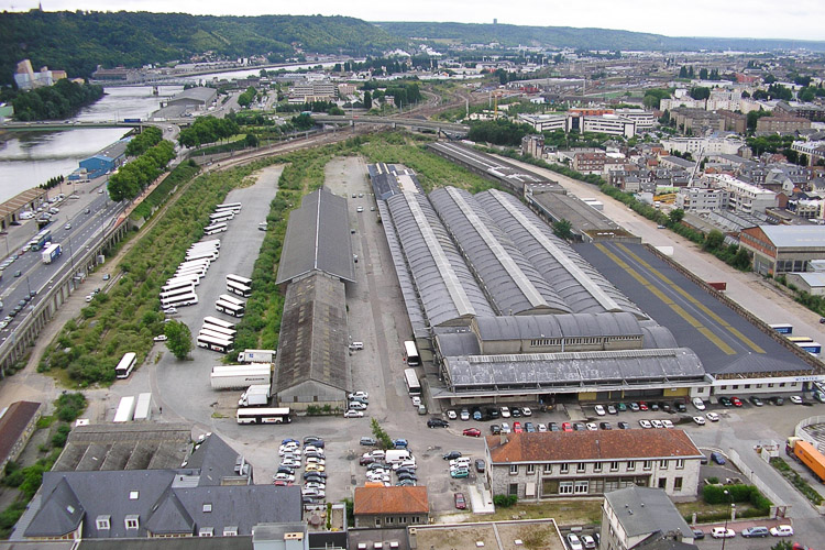
The first is the Saint-Sever Station land situated within the ring of central boulevards, an isolated brown field site which currently operates as a logistics centre. This isolated space will become the new left bank Station which, with its multimodal role, will form part of a new transport network that will underpin the emergence of a neighbourhood of an estimated 300,000 m², guaranteeing the diversity of an urban centre.
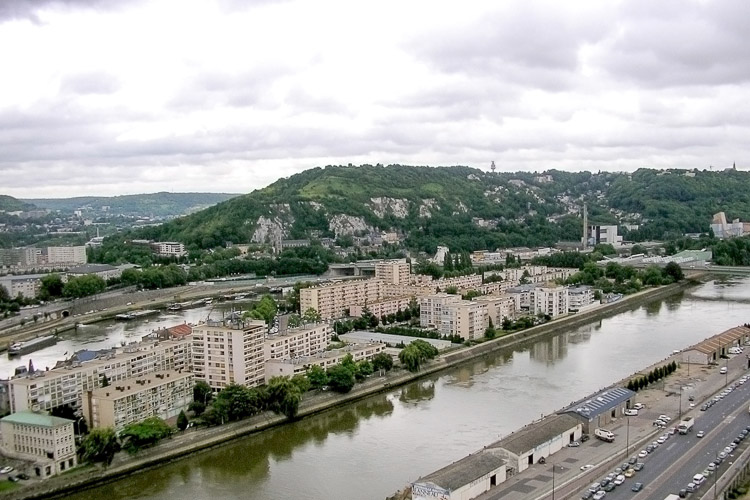
Since “Reconstruction”, Île Lacroix has lost its natural character. Its downstream section is home to large estates, housing some 3000 people (rental and condominiums). Upstream, it is separated from the residential area by Mathilde Bridge, which spans the island and houses several sports facilities and green leisure spaces. As a distinctive area within the city, its location and island character give it a strong identity, closely linked with the rhythms of the river.
Adaptability : main elements to take into account
- Taking a global approach to transformation
the dimension of the projects developed on the Seine axis (a land area of almost 150 ha) constitutes a major opportunity for the future of the city. This means that the potential changes in this sector need always to be approached from a twofold perspective, the local scale and the metropolitan scale. This transformation of the riverside landscape is a source of potential that needs to reflect new ways of life that that will be a fertile source for the city of tomorrow.
- An open context
While Île Lacroix poses an accumulation of problems – difficult access because of its relative isolation, the persistence of urban wasteland, a housing stock of modest quality (in the process of renovation), public and natural spaces that demand improvement – it has potential qualities that can be elicited. The ideal strategic position of the Station, its association with multimodal hub connected with a city neighbourhood, offer an unprecedented opportunity to remodel this part of the left bank.
- A project conducted over time
In order to give real substance to the ongoing metamorphosis, a long-term framework needs to be established for the public space, which is tuned to the long timeframes of change, can accept and adapt to alterations, the potential intermingling of programmes, mixed occupancies and alternative uses of space. Adapting to transformations means planning for transitional phases in the implementation process, associated with particular events, it means taking an experimental approach to specific timeframes in the deployment of public space and the construction or refurbishment of buildings. Establishing stable prospects for the urban quality of places and the social ambience of inhabited spaces means accepting morphological variations, temporary activities, a degree of reversibility.
- The reality of an iconic district
With regard to the sustainability of the river landscape, the task here is to specify the terms of an urban dialogue between city and nature, consonant with the existing context, in experimenting with the morphology of solids and voids, exploring densities and permeabilities, whilst weaving organic links between housing, amenities and activities.
The location of the project site, its connection with “the Seine axis”, the importance of the future left bank Station, the proximity of the island opposite, all demand an ambitious project.
Candidates are asked to put forward proposals relating to two scales:
On the scale of the wider perimeter, the remit is to develop strategic proposals based on a master plan that takes account of possible short-term and long-term changes, for a layered project that brings together the themes developed and relates them to an analysis of the urban environment and the municipality’s cultural policy.
On the scale of the project site, keeping in mind the future station, the remit is to propose potential urban and architectural forms that will generate a lasting quality of public space by modelling the urban landscape and the density of solids and voids around the Seine. The objective is to forge good community relations and comfortable exchanges and flows, in an equitable neighbourhood where living, working and learning will be possible. Scenarios for phased development should take account of the expected timeframes for the implementation of change.
Questions on the site
Existe-t-il une étude préalable sur la gare TGV ? Il y a-t-il un programme (surface, fonction, emprise au sol, nombre de voie, etc.) même sommaire, sur les besoins de celle-ci ?
La transmission d’information à ce propos est encore en discussion. Elle ferait l’objet, quoiqu’il en soit, d’une communication équitable pour tous.
Est-il possible d'avoir des informations sur le tracé de la futur ligne TGV, le positionnement de la gare et notamment l'impact sur les bâtis environnants la gare. Est-ce que certains seront impactés par le projet?
Ces informations techniques sont encore actuellement en gestation. La dynamique du concours Europan n’est-elle pas susceptible de justement influer sur ces choix ?
La ligne TGV sera-t-elle en cul-de-sac depuis Paris, puis reconnectée vers les tracés en rive droite par le pont en proue de l'île et via le tunnel? Ou des travaux de tunnelage seront-ils entrepris pour passer sous la Seine et se reconnecter sur le réseau à l'ouest de la gare rive droite? Ou sur les réseau rive gauche existant au niveau de la gare Rouen-Orléans?
Ce sont bien des travaux de tunnelage permettant la traversée de la Seine entre la rive gauche et la rive droite qui sont programmés.
Quelle est la nature de l'intervention programmée pour la rénovation des édifices présents sur l'île ?
Il s’agit d’une réhabilitation de type Plan Climat (travaux visant à des économies d’énergie) , lancée par les bailleurs sociaux concernant exclusivement le parc locatif.
Le fichier dxf intitulé ROUEN-FR-SS-M00.dxf ne fonctionne pas. Serait-il possible d'en avoir une version dwg ou alors de le scinder en 2 afin de pouvoir l'ouvrir ?
the file is ok
Could you give us the following documents? At the CREA scale: a-PLU; b-PLH; c-PADD; d-PDU; e-SCoT; f-PCET; g-PPRI and frequences of the water rises; h-SDAGE local i-map of dominating winds;
At the scale of the city of Rouen: j-general cadastre of the city of Rouen (dwg); k-map information on the historical development of the city; l-tramway and/or other public transportation projects
At the scale of the project area: m-indicative map of the urban webs; n-soil surveys; o-contamination surveys
Most of the documents are available on Internet; as far as the others are concerned this is seems a bit too early.
Would you give more precision on the picture under the file ROUEN-FR-SS-M12?
See Complete Site Folder where the pictures are given a comment.
Would you please communicate us the complementary perspectives that could help understand the typologies and densities for every project zone presented on the ROUEN-FR-SS-M12 document?
There is no other document to be transmitted to this day.
Quel est l'avenir de la ligne de chemin de fer passant sous le quai Jacques Anquetil?
the cargo's trafic will be stain, but we don't know about the future configuration; see the answers before;
Est-il possible d'avoir des informations sur le tracé de la futur ligne TGV, le positionnement de la gare et notamment l'impact sur les bâtis environnants la gare. Est-ce que certains seront impactés par le projet?
all informations included in site folder
Où pouvons-nous consulter les résultats des réunions publiques avec les habitants autour du devenir de l'ïle Lacroix (notamment celle qui a eu lieu le 2 mai 2013)? et pouvez-vous nous dire quand vous allez compléter les "réponses à venir"?merci.
1. we learn to see if there is an account
2. we strive to respond quickly, as far as possible.
1) Pourriez-vous nous transmettre un plan DWG avec les hauteurs des bâtiments ?
2) Un plan avec les niveaux des crues (les altimétries) ?
Combien de trains de marchandises circulent sur les quais sud et nord par jour ?
This is not regular, it depends on the pace of the port industrial area downstream traffic
Les sols de la gare TGV sont-ils pollués?
There has been no specific study. There may be various pollution due to usage over the years (garages trucks and vehicles including)
Pourquoi le centre aquatique est-il à l'abandon?
it's not.
Le fichier "ROUEN-FR-SS-M00.dxf" ne s'ouvre pas. Est ce que d'autres candidats vous ont fait part de la même remarque? Est-il possible de récupérer les fichiers "ROUEN-FR-SS-M03" à "ROUEN-FR-SS-M07" au format dwg?
we are asking for
Peut-on obtenir plus d'information altimétrique et topographique du site, notamment rive gauche et des ouvrages (quais existants, pont corneille, pont mathilde)? Par ailleurs, les documents M03 à M07 sont disponibles uniquement en format image ou pdf, très difficiles à transformer en altimetries fiables. Sont-ils disponibles en autocad? Peut-on disposer d'autres élévations longitudinales ou transversales des ouvrages?
We send requests
Peut-on obtenir le trace provisoire du TGV et l’emplacement prévu de la future gare sur site? Peut-on avoir accès à un document sur l’activité des rames de train sur le site existant ? (notamment la rame sous les quai Jacques Anquetil et vers la zone de Grammont ?
not possible
Peut-on avoir accès au support informatique des présentations réalisés à la mairie le jour de la visite de site, notamment sur les projets d’avenir de la ville de Rouen et les quartiers en développement?
ok; please wait with the vidéos af the launch event april 5th https://vimeo.com/album/2367024
Le PLU ne semble pas disponible sur internet. Il semble qu'il n'est pas encore été adopté. Pourriez-vous nous transmettre le projet de PLU?
not possible
Pourriez-vous nous transmettre le projet de PDU (introuvable sur internet) et qui ne semble pas encore adopté?
all actuals documents are also on CREA web site
"Ce sont bien des travaux de tunnelage permettant la traversée de la Seine entre la rive gauche et la rive droite qui sont programmés." : Pouvez-vous préciser l'ampleur des travaux de tunnelage envisagés ? où démarrent ils et où s’arrêtent ils ?
please read again the sitefile, no programm at all, only suggestions
Est-il possible d'avoir une photoaérienne et une semi-aérienne en haute définition?
we haven't any better documents
peut on avoir un minimum d'informations sur les gares existantes : - gare préfecture : existe-t-il un tunnel pour passer sous les voies ? - gare saint sever : quelle est la hauteur sous voute ? longueur de travée et nombre ?
no information
Les voies ferrées présentes sur le site sont-elles encore utilisées aujourd’hui? Si oui, quelle est la fréquence du trafic ? Dans le cadre du projet, leur utilisation pour le fret doit-elle être maintenue où seront-elles intégrées au projet de la future gare?
Railways are used for freight currently and will remain so. The traffic is not regular; the cargo will be maintained, we do not know under what conditions.
Dans le descriptif du projet, peu d’informations sont données concernant la future gare. Des orientations d’aménagement relatives à son implantation (quel niveau ? En surface ou en souterrain ?) et à sa capacité ont-elles déjà été retenues ? Qu’adviendra-t-il de la gare actuelle ? Son usage sera-t-il maintenu ?
see sitefolder
Est-il possible de connaître quels sont les terrains appartenant à la ville, notamment sur l’île Lacroix, afin d’appréhender les mesures à prendre pour d’éventuelles transformations ?
ROUEN-FR-PS-M04
Les plans fournis ne contiennent pas d’information concernant le nivellement du terrain hormis les quelques coupes ponctuelles. Est-il possible d’obtenir un plan avec les côtes de niveaux sur l’ensemble du site ?
all documents on sitefolder
This site is connected to the following theme
In-Between Time Adaptability is about processes that offer creative possibilities for a project to incorporate uncertainty, lack of funding, the unknown future role of the competition site, or even long-term territorial transformations that affect the site.
So how can the “waiting period” before implementing a project be structured in such a way as to facilitate multiple scenarios, to involve numerous stakeholders, ultimately to allow changes to the initial vision? The intelligence of a project can depend on different processes that arise out of the dynamics of the site context. In other words, given time, a project can, so to speak, grow organically out of the site.
Specific documents
Questions on the site
You have to be connected –and therefore registered– to be able to ask a question.
Fr. 16 May 2025
Deadline for submitting questions
Fr. 30 May 2025
Deadline for answers
Before submitting a question, make sure it does not already appear in the FAQ.
Please ask questions on sites in the Sites section.
Please ask questions on rules in the Rules section.
If your question does not receive any answer in 10 days, check the FAQ to make sure the answer does not appear under another label or email the secretariat concerned by the question (national secretariat for the sites, European secretariat for the rules).