Goussainville
The Synthetic Site Folder and Site Brief are available for free.
Please register and login to access the Complete Site Folder.
- Synthetic site folder EN | FR
- Site on Google Maps
- Back to map
Data

Category Urban – architectural
Location Communauté Agglomération Roissy Porte de France, Goussainville (95190)
Population Town of Goussainville 31,390 inhab. - CA Roissy Porte de France 87,514 inhab.
Strategic site 922 ha - Project site 52 ha
Site proposed by CA Roissy Porte de France, Town of Goussainville
Owner(s) of the site Town of Goussainville, private
Commision after competition Management of the architectural and/or urban project with partners
Team representative architect - urban planner - landscaper
More Information
How can the site contribute to the adaptable city?
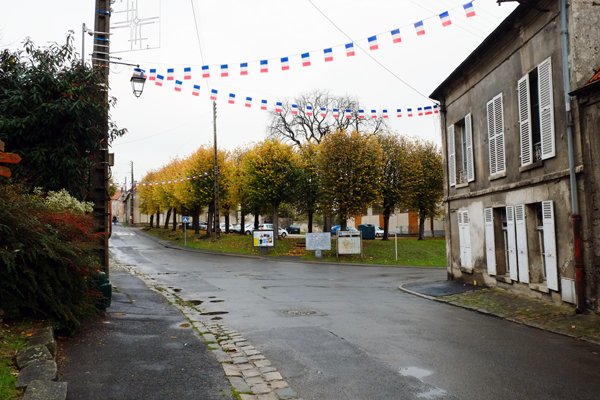
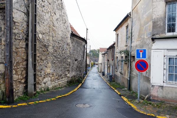
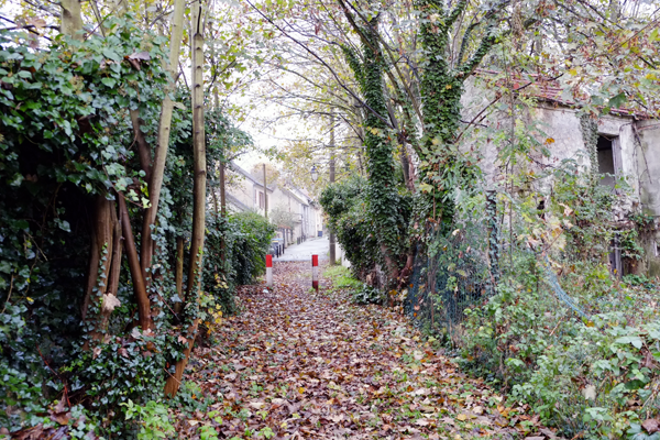
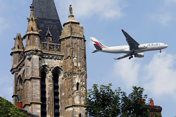
A member of Europan 12 for the community of Fosses, the Communauté d’Agglomération Roissy Porte de France is repeating its participation in the adaptable city competition, with a subject hitherto little explored: an old village, in a location affected by airport, metropolitan and agricultural influences. Affected by the presence of Charles de Gaulle Airport, the built fabric of the old village of Goussainville has been frozen for more than 40 years. Because of the Noise Exposure Plan (PEB), no new populations are allowed to settle there; and because of the protected perimeter around the church, none of the buildings can be demolished. As a result, numerous buildings are currently walled up, or in an advanced stage of dilapidation. Nonetheless, approximately 300 people still live in the village. The PEB’s regulations offer possibilities for development which, in the absence of an overview, have not been exploited. The Europan competition therefore offers an opportunity to develop forward-looking projects in a territory that is caught between times, spaces and lifestyles: between yesterday and tomorrow, between here and elsewhere, between rootedness and nomadism. A symbol of the adaptable city, subject to some of the toughest constraints found in the vicinity of a big city, can the old village be regenerated and restrictions turned into advantages?
City strategy
A strategic economic territory north of Grand Paris, Grand-Roissy is currently the focus of several studies seeking improvements in the urban connections, greater urban integration of the airport platform, a better balance between habitat and activities and better management of space and natural resources.
Situated immediately adjacent to the “airport city”, at one of the only two entries to Goussainville, full of landscape and architectural qualities which protected it from demolition when the airport was built, the historic village has the potential of becoming a unifying element amidst the surrounding urban archipelagoes, with the capacity to change perceptions of an area too often considered as a “support function”. The Municipality is therefore looking for projects with a vision for the future, that will support the transition from a hypo-metropolitan space to a hyper-metropolitan space.
Site definition
The project site corresponds to the historical village of Goussainville, also called the “old country”. Nestled in the Croult Valley, a small indirect tributary of the Seine, the village forms an island in the heart of a highly dynamic territory. To the west, an extension of the historical village, now a town centre, has developed on the plateau along the Paris-Lille railway line, now essentially used by the RER D regional express. The new Northern High-Speed line runs along the eastern end of the site. To the east, Paris-Charles de Gaulle airport, the world’s third biggest in terms of passenger flows and world number one for airfreight, is an interregional employment hub. To the north, the territory is connected to the Paris “orbital expressway”, also called “la Francilienne”. Finally, a major multimodal freight project (air/TGV) called “CAREX” is due to be located on the eastern part of the site. However, these infrastructures also cause a number of problems: spatial segmentation, urban isolation, noise exposure and atmospheric pollution. Today, the Noise Exposure Plan sets a population cap of around 300. The village has a garage, a carpentry business, a school, a few community premises and also the village hall, which is used by all the inhabitants. Despite the strong constraints, the village is still a sought-after place to live.
Future of the site in relation to the site family and Adaptability
The connection with the adaptable city theme takes a number of forms:
- providing a structure that will place the village within a wider territorial network; considering the infrastructural links but also the more local networks, such as hiking trails;
- exploiting the existing landscape qualities, integrating the river valley into ideas for walking and cycling routes, and the connection with the surrounding entities;
- thinking about heritage in the process of village transformation (landscape & urban heritage, vernacular architectural heritage, 12th century church...);
- thinking about forms of occupancy compatible with the Noise Exposure Plan and atmospheric pollution; thinking about the question of residential and dormitory housing in relation to the proximity of the airport and the associated activities;
- imagining village revitalisation, proposing programs in synergy with the economic dynamics at work in the territory. Proposing appropriate uses for certain places identified as crucial: the château, the stables, the park;
- including the village population in a process of shared village transformation. Proposing ways of life appropriate to the territory;
- taking into account public land ownership in the project process;
- imagining new integrated project processes, influenced by new uses and new activities, as a way of establishing a role model for many old localities that have become inert because of a complete upheaval in their environment, particularly their incorporation into metropolitan space.


Questions on the site
May we have Autocad files of topography, cadastre, toponymy, existing building and road network on the studied area at least?
The files for the towns of Louvres and Thillay have been upload on the FTP.
Is it possible to get a copy of the planning rules / land use plan?
The land use map has been uploaded. However Europan is competition of ideas, candidates are invited to set up answers that fit the problematic of the site’s complete file.
In the visit report of March 13th, it is written in the questions’ answers that several documents should be added: patrimonial map with the buildings to keep; a map of the city’s real estate; a map of the inhabited areas. Where can we find those?
The patrimonial map with the buildings to keep has been added. It has to be put into perspective of the « jewel in its box » notion of the church developed by the Architecte des bâtiments de France during the visit.
The map of the city’s real estate is in the site’s folder.
The map of the inhabited area is not available.
BDuring the visit, a question has been asked about an occupancy map of the « Vieux pays de Goussainville ». When will it be available on the site ?
This document doesn’t exist.
Is it possible to get a document which allow to distinguish actual houses from houses boarded up, which had been bought by ADP and are now city’s property ?
This document doesn’t exist.
We don’t understand the limits of the strategic site. Can we have a .dwg map with those limits?
The strategic site is limited on the West, North and East by RER D, the N104 and the D317. On the south, the limit follows the Crould, the D4, goes through the Patte d’oie Park until the D317.
Can we have accurate topographic lines for the project site?
This data is not available. You may however have a look to Geoportail web site.
Is there any difference between walled-up houses and abandoned houses? Are they all City properties?
Those houses are property of the city of Goussainville. They have the same statutes.
May we have a map or documentation which showcases the buildings inhabited by the 300 inhabitants of the old country nowadays?
This document is not available.
Buildings with a « demolishing permit granted » (doc 6/12/2004) will they be actually demolished? Shall we refer at the “simulation avec disparition du bâti ADP” as something certain?
You must not take this document literally. It is not a demolition demand to the competition teams; it is a study from 2004. It however allows considering some demolition for the teams who wish to.
Is there any compulsary scale for each board or is it "free scale"?
The choice of scale is left to the participants.
May we have the plan of the castle and the stable?
The plan is on line on Europan’s website in .DWG file. in the 'New docs after launch' file.
May we have the impact study which most probably goes with the Carex project?
At this state of the CAREX project, the impact study has not been realised yet.
May we have more accurate .DWG file on the old village (main plantations, urban furniture, sidewalk…)?
The document is not available.
In the survey “Roissyphérique” (link available in the visit resume) there isn’t a stop signal at the RD47 / RD47a crossing whereas what is written in the visit resume. What shall prevail? Which stop is closer from the old village? The Carex one?
At this state of the Roissyphérique survey, no station plot has been definitely validated. It should be taken into account the hypothesis of a station “close to” the Vieux Village. The road crossing between RD47/ RD47a is one of the option that can be used by the candidates.
Is the scale free in each board or is there any compulsary scale? Because in the site documents don´t referee any accurate scale.
Your produced documents are at free scale.
This site is connected to the following theme
How to create positive dynamics from a difficult situation? Many sites are faced with difficult urban situations. The origins of these difficulties are to be found in problems caused by urban, economic and environmental factors, as well as differing values and a lack of cultural understanding. Despite these difficulties, the sites nevertheless constitiute a favourable ground for the creation of new dynamics which rely on scenarios of sharing and the adaptation of traditional architectural and urban tools.
Specific documents
E13 FR - Launch: Goussainville & La Corrèze
Questions on the site
You have to be connected –and therefore registered– to be able to ask a question.
Fr. 16 May 2025
Deadline for submitting questions
Fr. 30 May 2025
Deadline for answers
Before submitting a question, make sure it does not already appear in the FAQ.
Please ask questions on sites in the Sites section.
Please ask questions on rules in the Rules section.
If your question does not receive any answer in 10 days, check the FAQ to make sure the answer does not appear under another label or email the secretariat concerned by the question (national secretariat for the sites, European secretariat for the rules).