Metz
The Synthetic Site Folder and Site Brief are available for free.
Please register and login to access the Complete Site Folder.
- Synthetic site folder EN | FR
- Site on Google Maps
- Back to map
Data
Category Urban
Location Metz Métropole – Augny, Marly, Moulins-Lès-Metz (57)
Population City 120,000 inhab. - Conurbation 230,000 inhab.
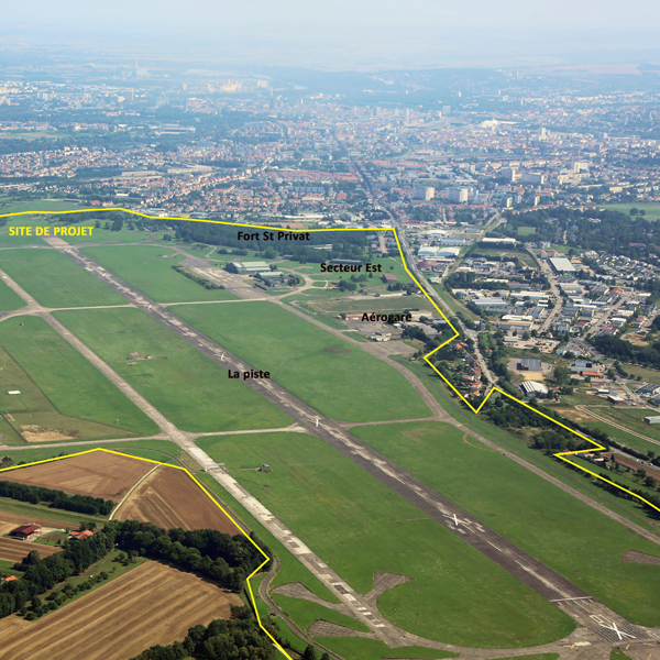
Strategic site 600 ha - Project site 350 ha
Site proposed by Metz Métropole ; Etablissement Public Foncier Lorraine
Owner(s) of the site Ministère de la Défense, future owners : Etablissement Public Fonction Lorraine and Metz Métropole
Commision after competition Organisation of a workshop with the chosen teams – further in-depth urban study – project management assignments for public spaces – participation process. Follow-up operations can be initiated with private partners.
Team representative architect - urban planner - landscape architect
More Information
How can the site contribute to the adaptable city?
Formerly a 400 hectare monofunctional site, closed to the public, BA128 needs to be gradually converted into a jointly managed shared space, open to everyone, incorporating multiple uses, and thereby to be integrated gradually into its immediate urban and natural environment.
To achieve this, 4 primary uses have been chosen: sports and leisure, renewable energy, periurban agriculture and small business activities.
This profound transformation is based on the following principles:
- The introduction of a long-term process including the recycling and reversibility of uses and spaces;
- A rational use of space, by pooling public and private spaces and amenities;
- A focus on the relation between city and nature which entails protection of natural areas and the provision of high-quality services;
- A new way of constructing and managing projects, which aims to foster the emergence of local initiatives and include a wide variety of potential stakeholders.
City strategy
After developing to the north and then to the south-east, the conurbation is beginning balanced development to the south-west, triggered by the Military’s release of Airbase 128 at the heart of a strategic area.
The aspiration for the conversion of the site depends on three prerequisites: a desire to develop job and wealth creating activities, in particular targeting sectors that offer a potential for growth and innovation; a desire to capitalise on the model of Centre Pompidou-Metz in expanding the city’s influence; a desire to bring the population closer to jobs and services in order to improve their quality of life.
The conversion of military and industrial brownfield sites, to be undertaken by Metz Métropole, offers real potential for renewal and large-scale support for the aspiration.
Site definition
Former Airbase 128, the project site, a 370 hectare enclave closed to the public for more than a century, located on the edge of built-up areas in the conurbation centre, constitutes a transition between the built-up fabric in the north and the large agricultural landscapes in the south. To the east and west are small business and commercial zones, in particular ACTISUD, France’s second-largest commercial zone (outside Île de France) in terms of sales area. Well served by road infrastructures, the area that constitutes the study site nevertheless suffers from a shortage of public transport, which could be an obstacle to its development.
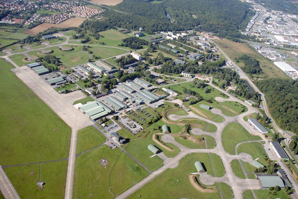
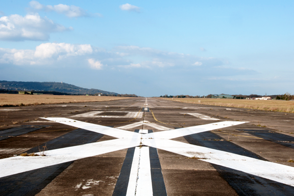
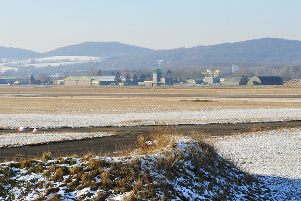
The project site is characterised by three landscape units: in the centre an open area of more than 200 hectares of meadows corresponding to the mass of the runway, enjoying views over the slopes of Moselle and Mont St Quentin to the north and over agricultural areas to the south, where the only vertical entities are the aeronautical hangars on either side of the runway; to the west, the landscape of the former airbase living quarters resembles an urban park, containing housing and administrative and technical buildings; to the east, the historical area is marked by the presence of an old fort and numerous sheds.
Future of the site in relation to the site family and to Adaptability
Several studies have led to the development of a formal strategy for the reuse and conversion of the site in the short, medium and long term, set out in a document: the Development Master Plan. In addition to a land reserve to the north, because of the typology of the buildings in the north-east of the base, this area is suitable for small business and logistics activities. As for the south of the base, it will host two iconic projects with a shared philosophy and potential synergies: the agricultural cluster (agrobiopôle) and a sports cluster.
The purpose of the agricultural cluster (agrobiopôle) is to provide the conurbation with short local food supply circuits. The site is to be the epicentre of periurban agriculture for Metz Métropole and will offer shared-use production, storage and processing facilities for producers, and places for the conditioning and sale of agricultural products.
The sports excellence cluster project is intended to support the amateur and professional sports sector in the conurbation and in Moselle. This aspiration reflects the needs of public and private actors, by providing several shared-use services and facilities useful for training, accommodation, practice and the hosting of sports competitions, events and meetings.
Apart from the economic function of these two projects, they also aspire to a role that is social (services to the population, public access), educational, innovative and exemplary. Their success will be based both on participatory construction and on the appropriation of the amenities by the population.
The ideas for the project site focus on the following characteristics and objectives:
- An exceptional but unknown site: encourage the gradual appropriation of the site by its new occupants and by inhabitants of the conurbation;
- A need for openness and vitality: open the site to the outside and organise its internal communications to attract new and multiple uses, while maintaining/enhancing the natural spaces and the legacy elements of the place; foster intensity of life on the site through places where people can do things together at different times, thereby allowing a multiplicity of uses;
- An innovative participatory process that is already in place but needs to be broadened and strengthened: devise a participatory process that will both create synergies between projects, whether geographical or economic, but will also lead to the emergence of a more participatory economic construct.
The candidates will propose for the site:
- A development strategy and spatial programming, both short and long term;
- Principles for the planning of public and leisure spaces and movement;
- Amenities that promote the attractiveness of the site, prioritising both education and a mutual circular economy between projects;
- A process of co-construction by all the stakeholder partners and by the population.
Teams are expected to be multidisciplinary, notably including skills in urbanism, architecture, landscape architecture, economics and sociology.
Questions on the site
Are the "economic and sociological" skills absolutely needed and therfore restrictive, or are they only desirable?
They are desirable. We though of it as relevant to develop them due to the nature of the subject.
Is there a visit report and if so, where can I find it? Besides, is it possible to see the site again or is another visit planned?
The site visit report is available on the site page in the right column, section "Site Visit".
Metz Métropole organizes site visits outside of the Europan competition. Please contact contact@europanfrance.org if interested.
Can we imagine the creation of accommodation on site in the long-term?
Housing can be considered on the East of the BA, in the municipality of Marly. On the West, in the municipality of Augny, we rather consider hotels, student residences, etc.
Can we have a map in .dwg of the site with the whole city of Metz?
In the framework of the EUROPAN competition on the site of the BA, this document cannot be provided.
This site is connected to the following theme
How to integrate vacant sites in urban development? Changes in economy, governance or society can give rise to overwhelming vacant spaces in the urban landscape: entire building complexes waiting for new users, former military zones, leftover green areas... These spaces cannot be taken up in normal/organic urban development as they are far too large and in need of full adaptation. Where should we therefore search for elements to fill the emptiness up and when can we consider it as a value? How can we give sense to vacancy and integrate it in new ways of making the city?
Specific documents
E13 FR - Launch: Bordeaux & Metz
Questions on the site
You have to be connected –and therefore registered– to be able to ask a question.
Fr. 16 May 2025
Deadline for submitting questions
Fr. 30 May 2025
Deadline for answers
Before submitting a question, make sure it does not already appear in the FAQ.
Please ask questions on sites in the Sites section.
Please ask questions on rules in the Rules section.
If your question does not receive any answer in 10 days, check the FAQ to make sure the answer does not appear under another label or email the secretariat concerned by the question (national secretariat for the sites, European secretariat for the rules).