Amiens (FR)
The Synthetic Site Folder and Site Brief are available for free.
Please register and login to access the Complete Site Folder.
- Synthetic site folder EN | FR
- Site Brief EN | FR
- Site on Google Maps
- Back to map
Data

Project Scales XL/L/S - Territorial, urban and architectural
Location City of Amiens, Montières business area
Population Conurbation 175,259 inhab., City 132,699 inhab.
Strategic site 170 ha – Project site 25 ha & 32 ha
Site proposed by City of Amiens and Amiens Métropole
Actors involved City of Amiens and Amiens Métropole in partnership with Amiens Picardie Chamber of Commerce and Industry, OPH Amiens (Housing Public Agency), Departement de la Somme, Region Hauts-de-France, Club des entrepreneurs de Montières, private owners
Owner of the site City of Amiens, Amiens Métropole, private owners
Post-competition phase Urban study, urban planning for the strategic site, project for restructurings of public places and architectural realizations
Team representative architect, uban planner, lanscaper
More Information
How can the site contribute to the productive city?
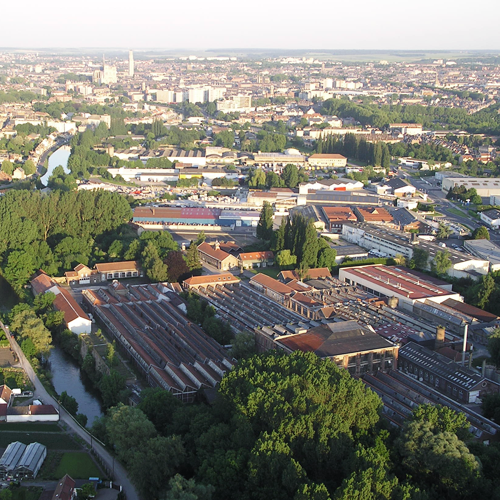
The historic industrial zone of Montières in Amiens is a monofunctional space created by urban zoning. If its original industrial vocation has gradually evolved towards artisanal, service, business or leisure activities, the closing and departure of businesses has left a lot of wasteland (30 ha). The management, temporary and long-term occupation and ultimate reconversion of this area are major urban issues. Montières –located close to the centre of Amiens, the suburbs and the banks of the Somme– encourages thoughts on mixed use. This in turn brings up two major questions: how to live in a production area and how to assure the maintenance, development and arrival of activities while at the same time opening up the site to other functions, particularly residential?
City strategy
Despite having recently lost its status as regional capital the Amiens Métropoloe has to strengthen its position in the greater Paris basin by affirming itself as a “fertile city”. A territory of living and daily commuting, the city has to fine-tune its organisation in order to preserve the quality of life and meet the needs of its inhabitants. The city must provide the conditions for a balance between residential, economic and commercial development, enhanced accessibility and intermodality while at the same time preserving those amenities that have granted it the status of “life-size city”. Its development tends to revolve around the river, which is responsible for such urban problems as the reconstruction of the city into itself, but also allows the city to be part of a network of projects on a scale with the Somme valley.
Site definition
The study site is the Montières business zone, a monofunctional site located along the river and made up of large industrial and commercial areas. One of them, the Cosserat factory, is going to be reconverted, bringing up the issues of programme diversity and the environment. The emergence of new business to the west of the city centre also raises the question of the in-between, particularly the area to the east of the business zone (along the banks of the Somme, between the city centre and Cosserat) and its southern edge (the Sully site: between the old factory and the suburb of Hem). The issues posed by two sites are characteristic of these sectors: the Step and Orion abandoned sites on the one hand, and the Espace Alliance and Immochan site on the other. These are the two project sites proposed by the community.
How is Production Considered in the Urban Diversity Program?
Water resource is at the origin of the development of two activities that have today almost disappeared but have profoundly marked the Amiens territory: market gardening (floating gardens) and the textile industry. Today, this resource is being reconsidered in terms of food self-sufficiency, cycles and short circuits (production and distribution) or energy independence. In addition, the natural and architectural heritage of the valley is the foundation for new developments. Even if there are already real tourism assets (an exceptional location close to Paris, the Somme bay and historical Second World War sites or then the quality of the built environment twice recognized by UNESCO), the city is seeking to increase its attractiveness mainly for short holidays and business tourism. For that, Amiens is counting on the notion of “life-size city”, which is based on its natural heritage: the Somme, the floating gardens and the bicycle route. The Amiens Métropole Pact for Employment and Innovation describes an innovative urban schema for the deployment of clusters along itineraries near the river. This urban strategy must extend the energy of the city centre particularly to the west and the Montières zone, a monofunctional space where existing activities and ecosystems need to be preserved and gradually hybridized with new, compatible functions. The continuity of urban and natural spaces and quality of the itineraries should guide a project structured around points of intensity and shared public spaces.
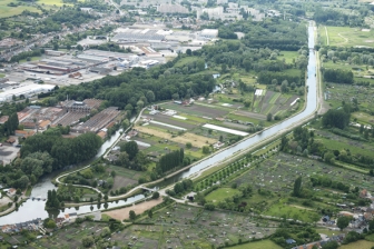
 Aerial view of St-Aragone island
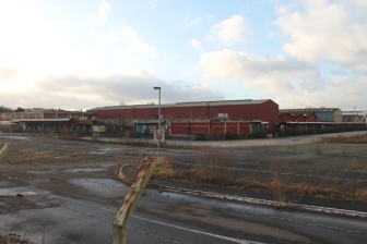
 Cosserat factory
 Orion silos
 Immochan Site
Questions on the site
Two sites are defined inside the study perimeter. Do we have to submit one project on the two sites or do we have to pick one of them?
We remind you that the sites perimeters are indicative and that they may be interpreted in various ways by the candidates but always be justified by the approach taken. The study site perimeter defines the whole territory concerned by the issue involved. Thus, it can be broaden or reduced depending on the candidates' approach. The project perimeters define more precisely the sites offering an operational potential. On Amiens site and after multiple hesitations and common thoughts with the municipality, it has been decided to propose two project sitescorresponding to different operational potentialities in both long run and current situations. The Step-Orion site is basically becoming a brownfield whereas the Alliance site has already been transformed and tends to be expanded restructured. Great freedom is given to candidates regarding the chosen perimeter. It is possible to consider the entire site as one project site with different temporalities and mechanisms; but it is also possible to answer partially on one site or another, on one part of the two sites, etc. depending on the proposed strategy and the process relevance implemented over time. In any case, choices will have to be explained.
Is there a more precise list (maps, ground floor and floors sections) of the existing buildings on the "Orion", "Step" and "Immochan" sites ? If not, would it be possible to carry out one in situ ?
The municipality doesn't have any plan of the Orion or Step buildings. It won't be possible to carry out one directy on the site as the Orion site is dangerous and buildings are in poor condition. The city cannot take responsability to do that. Regarding the Step site, the few buildings left will be destroyed, except for the skatepark for which the restructuration is taken in charge by the Amiens Métropole services. Regarding the Immochan site, here again, the municipality doesn't have the buildings plans because the competition partner does not own the site yet. As a matter of fact, he cannot provide authorization to carry out plans on the site and it's not possible to involve him to that extent.
We tried to reach the Club des dirigeants of Montières to exchange some views with them. We haven't got any answer yet... We would also like to talk with associative representatives, residents of Etouvie district. Do you have more precise and relevent contacts to share ?
We remind that during the competition phase, no individual contact is allowed. In addition, we don't have any contact to give regarding residents associations or the club des dirigeants of Montières.
Do you have any information regarding the origin of the various soils of the sites ? Are they backfills ? If this is the case, where are they coming from ?
No soil study has been undertaken on the project sites. Consequently, the city has no information to give to the candidates at this stage. Generally speaking, the city believes these informations are not necessary for the competition. However, the city recalls the information in the site brief, in the paragraph about the flood prevention plan (PPRI): on the water treatment plant site, the groundwater is located in average at 1 meter below the ground; thus underground constructions are not welcomed. On the Immochan site, given the topography, the groundwater is probably located a little bit lower.
Does a map with terrain curves of e.g. 0,25 m or less exist, and is it possible to receive?
The city included a meter topographical plan in the complete site folder. There is no more precise document.
What is the possible evolution of the train servicing of the activity area in Nord Montières ?
A "railway node" study was conducted by the Region in order to study the feasibility of a "tram-train" type project that would re-use the existing railway lines. The result of the study was a lack of relevance regarding the financial investment and the technical problems generated by such a project. It was therefore abandonned.
This site is connected to the following theme
From Productive Area to Productive City What kind of Urbanity for the Logistics & Industrial Areas? The contemporary city is divided between very active big box urbanism linked to all metropolitan networks and light industrial sites adjacent to city centres. They operate in isolation to their adjacent areas with mono-rhythmic uses.
What kind of Urbanity for the Logistics & Industrial Areas?
The challenge is to inject new economies that would generate synergies between uses, but also porosities resulting into poly-rhythmic urban milieu. How to develop common shared spaces between users of diverse activities as well as with the inhabitants of the surrounding areas?
Specific documents
Vidéo réalisée lors de la visite du site d'Amiens, le 7 mars 2017, en présence de : Jean-Christophe Loric, Adjoint au Maire chargé de l'urbanisme Jean-François Claisse, Elu de la Ville d'Amiens et de la métropole, en charge de l'accessibilité Vincent Massart, architecte urbaniste, Ville d'Amiens Gérald Decayeux, Propriétaire de l'espace Alliance
Questions on the site
You have to be connected –and therefore registered– to be able to ask a question.
Fr. 16 May 2025
Deadline for submitting questions
Fr. 30 May 2025
Deadline for answers
Before submitting a question, make sure it does not already appear in the FAQ.
Please ask questions on sites in the Sites section.
Please ask questions on rules in the Rules section.
If your question does not receive any answer in 10 days, check the FAQ to make sure the answer does not appear under another label or email the secretariat concerned by the question (national secretariat for the sites, European secretariat for the rules).