Pantin, Métropole du Grand Paris (FR)
The Synthetic Site Folder and Site Brief are available for free.
Please register and login to access the Complete Site Folder.
- Synthetic site folder EN | FR
- Site Brief EN | FR
- Site on Google Maps
- Back to map
Data

Project Scales L/S - Urban and architectural
Location Métropole du Grand Paris, Pantin, Ecoquartier Gare & Porte de l’Ourcq
Population Grand Paris Metropolis 700,000 inhab., Pantin 53,816 inhab.
Strategic site 189 ha – Project site 10.2 ha
Site proposed by City of Pantin & Etablissement Public Foncier d’ile-de-France
Actors involved City of Pantin & Etablissement Public Foncier d’ile-de-France, SNCF Réseau, concessions of Renault and Citroën
Owner of the site City of Pantin (public spaces), EPFif, SNCF Réseau, private owners
Post-competition phase Architectural and urban project management commissions
Team representative architect, uban planner, lanscaper
More Information
How can the site contribute to the productive city?
Located close to Paris along structuring transport routes (roads, railways, waterways), the site has been, since the middle of the 19th century, an important place for industrial, craft and logistics activities that have an operational link with the capital. A significant part of these activities could be maintained despite the deindustrialization during the second half of the 20th century. The turn of the 20th century is characterized by tertiary activities that benefit from an increased offer of public transports: creation of the new RER E rail connection with Saint-Lazare station (Paris) and Eastern part of Ile-de-France; construction of the T3 tramway on the boulevards des Maréchaux of Paris.
City strategy
Pantin is willing to benefit from the main communication radial axes that have built the city’s industrial and crafting history in order to have sustainable productive functions in a renewed and highly qualitative urban fabric. To do so, the city has been developing for several years an active strategy of urban transformation of its territory with the following aims:
1- developing mixed neighbourhoods on a section of the former industrial estates while maintaining the activity;
2- reconnecting isolated neighbourhoods with transports clusters;
3- integrating craft activities in a mixed urban fabric combining housing and amenities;
4- facilitating the sharing of public spaces by all the users : inhabitants, workers and economic actors.
Site definition
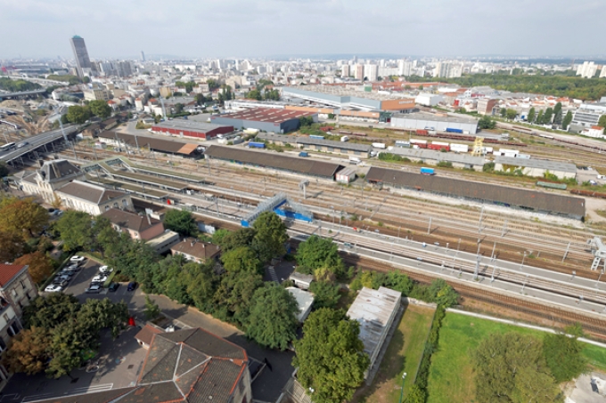
The site is characterized by the presence of radial transport infrastructures that connect Paris to the Great East. The railway cluster, the Canal de l’Ourcq, and National Roads 2 and 3 have been partitioning the Pantin urban space into a districts patchwork with fairly distinct functions. These districts are currently experiencing an important urban transformation drive. On the North-Western part, the Quatre-Chemins district is the subject of a project for slum clearance, housing creation and artisanal pole development. On the North-Eastern part, the city is conducting a reflection on the requalification of the significant Cartier Bresson activities zone. On the centre, the North fringe of the railway cluster will over time be replaced by the ZAC Ecoquartier de la Gare, a joint development zone that will accommodate housing, offices, amenities and activities as well as a 2.5 ha park. It will be articulated with the city hall district and the SNCF station with a new pedestrian crossing. On the Southern part, the ZAC Grands Moulins (3.7 ha), which the first stage has just been delivered, is developing a mixed programming: tertiary and housing. The Portes de l’Ourcq sector occupied by two big garages is also the subject of a city reflection regarding their integration in the new functioning of urban areas.
How is Production Considered in the Urban Diversity Program?
The city is willing to develop new spatial morphologies adapted to three configurations:
1- Portes de l’Ourcq sector: mutation of car dealerships with a maintained economic activity on the site or nearby; release of a part of the land occupation allowing the development of a mixed neighbourhood and the enhancement of an area located at the entrance of the city and near the canal;
2- on the North-western part of the ZAC Ecoquartier: creation of an activity block taking advantage from the railway and the vicinity of the Boulevard Périphérique;
3- on the Northern part of the ZAC Ecoquartier Gare: architectural development of a mixed block with offices, shops, activities and housing.
Thus, the city is expecting a general reflection allowing identifying project strategies that should be implemented to support the transformation of the site. What kind of processes could be conceived for the mutation of economic right of ways? Should they be kept on the site or relocated – temporarily or permanently? What urban and architectural forms could be imagined to reconcile in one same area, functions that have until now been separate? On the study site, it will be necessary to think about an economic activities programming that is innovative and suitable for nearby residential practices. To do so, it will be necessary to consider synergies with the existing activities in the area (artisanal pole, Cartier Bresson ZAE (Economic Activity Zone), car dealerships), and rely on the ecoactivities sector which is currently in a structuring process around the “Cité de l’écohabiter”. The objective is to design the most appropriate urban and architectural forms to welcome this programming by integrating adaptability and reversibility principles.
 View of the west part of the freight site from Avenue Edouard Vaillant
 The Gare de Pantin - Quatre Chemins eco-district
 View of the Renault site from the Tramway
 View of the West part of the freight site from the street
Questions on the site
It is mentionned in the site visit report that, regarding the CCU-CCR building, "the outline and building accesses may be published. The SNCF will however be questioned by the city. Renault will communicate a plan with location of services and surface area estimates." When will these documents be available ?
The plans owned by the city come from the competition. It is not possible to provide the candidates with other plans as the building permit is under investigation. The documents were added to the downloadable documents lists in the "0_New_docs_after_Launch" folder.
What type of function is there in the building between rue Auger and rue du Congo ? Are there any project for this area? It's outside the project site but very closed so we have to consider it in our reflections.
The building located in 48 rue Auger is named in the site brief as "Rizerie". It is currently occupied by art craft activites. The city didn't want to integrate it into the strategic site as it will soon be owned by Hermès group and is already part of an activities building development project under consideration. As the building permit has not been granted yet, it is not possible to provide the candidates with any information.
We didn't understand if the existing railways warehouses in the nord area have to be maintained or not. In the ZAC project they are demolished and rebuilt with new shapes, but during the site visit you have spoken about maintaining it for their industrial historical value. We would like to have precise indications about that.
The opportunity of a possible hall conservation the site regarding the technical, historical and patrimonial quality of building is left to the appreciation of the candidates.
This site is connected to the following theme
And productive again! How to Reintroduce the Productive Economy into New Urban Districts? Many formerly industrial places in and around cities are now out of use. Buildings were left in a derelict state, activities have been moved or stopped, sites became brownfields. Obsolescence is the common feature of these sites and the future is uncertain. Mostly, we dream of turning them into new vibrant urban quarters. But to avoid total gentrification as it has appeared many urban renewal projects in the past, we should perhaps try to put some productive activity in these sites… again? Because these sites were once industrial and linked to the city. Because there is a will for a really mixed city, and that mix includes productive economy as well.
How to Reintroduce the Productive Economy into New Urban Districts?
Specific documents
Vidéo réalisée lors de la visite du site de Pantin, le 15 mars 2017, en présence de : Charline Nicolas, Adjointe au Développement Durable et à l’Environnement, Ville de Pantin Olivia Metz, DGA Département Développement Urbain Durable, Ville de Pantin Carole Bourgeois, Responsable de la Mission Grands-Quatre Chemins, Ville de Pantin Pauline Robert, Directrice de l’Aménagement et du Commerce, Ville de Pantin Marion Baudouin, Chargée de projets Aménagement , Ville de Pantin Fabien Gautier, Direction de la stratégie et des montages immobiliers, Renault Julie Rancon, Chef de projets foncier, Établissement Public Foncier Ile de France Xavier Goussard, Responsable Ressources Humaines, Ville de Pantin
Questions on the site
You have to be connected –and therefore registered– to be able to ask a question.
Fr. 16 May 2025
Deadline for submitting questions
Fr. 30 May 2025
Deadline for answers
Before submitting a question, make sure it does not already appear in the FAQ.
Please ask questions on sites in the Sites section.
Please ask questions on rules in the Rules section.
If your question does not receive any answer in 10 days, check the FAQ to make sure the answer does not appear under another label or email the secretariat concerned by the question (national secretariat for the sites, European secretariat for the rules).