Šibenik (HR)
The Synthetic Site Folder and Site Brief are available for free.
Please register and login to access the Complete Site Folder.
- Synthetic site folder EN
- Site Brief EN
- Site on Google Maps
- Back to map
Data

Project Scales L - Urban and architectural
Location Šibenik
Population 46,332 inhab.
Strategic site 173 ha – Project site 33 ha
Site proposed by City of Šibenik (municipality)
Actors involved City of Šibenik
Owner of the site City of Šibenik (municipality)
Post-competition phase Urban study, masterplan
Team representative Architect, urban planner
More Information
How can the site contribute to the productive city?
The City of Šibenik base its prosperity on entrepreneurship, industry, tourism and good transport connections. Development priorities of Šibenik are directed towards the development of productive activities and the development of supporting structures.
Development of the designated area into a new residential area, with commercial and tourist spaces, high urban standards and values, supporting urban functions, social infrastructure and with their integration into a solid, high quality public space; will contribute to the transformation of the whole area and to achieving the productive city.
City strategy
Šibenik has recently started a transition from the industrial town into the attractive tourist destination. One of the projects that are in accordance with the City’s orientation to the tourism development is Project TEF (for "Tvornica elektrometala i ferolegura", i.e. "Electrodes and Feralloys Factory").
According to General urbanistic plan of Šibenik, it is required to make an urbanistic development plan for TEF which will precisely define the future use of the entire space. With a proper organization of the space, project area should upgrade and thus extend the city centre itself, as well as serve as a model of a transformation of an industrial zone into a new area of high-quality urban living. Former TEF area thus becomes an extension of the city centre.
Site definition
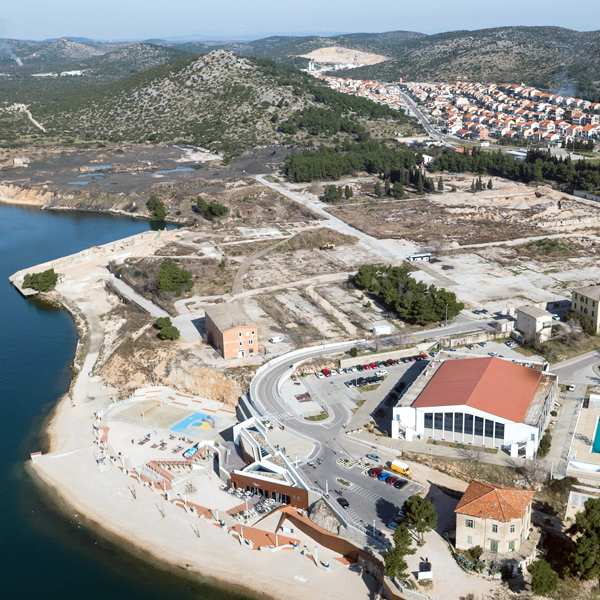
The project site, former Electrodes and Feralloys Factory (TEF), is located near the western entrance of the city and therefore represents the key potential of the city’s development. Located on the coast and near the old city centre makes it the prime location in the city of Šibenik.
This area used to be an old city neighbourhood and it ended up on the outskirts because the factory limited any expansion. Now that the factory was removed and after the entire location is refurbished, we have the possibility to expand the city and commercialise the land as well as the naval and coastal belt around it, since the channel in front of the former factory leads directly towards Skradin and the entrance of National Park Krka.
According to the Spatial development plan of the City of Šibenik and General urbanistic plan of Šibenik the land is defined as mixed use zone for commercial, residential or tourism/residential purpose.
How is Production Considered in the Urban Diversity Program?
The former Electrodes and Feralloys Factory stopped its production in 1994, which was immediately followed by its dismantling and land remediation. The former backbone of Šibenik’s economy today serves as a place where fairs, concerts and similar events are held. Because it is located near the western entrance to the city of Šibenik, it represents the key potential of the city’s development. This attractive location which includes great traffic connections and attractive environment of urban areas and tourist centers makes the former TEF site extremely attractive for future investments.
Except the possibility of building residential and commercial facilities within the construction zone, it is possible to restore green surfaces (parks, forest parks, protective (buffer) green zones), as well as other facilities and surfaces which are needed for the normal functioning, with the purpose of restoring and protecting the environment. This allows construction of traffic and pedestrian paths, bicycle paths, sport and recreation areas and playgrounds, smaller service, hospitality and commercial facilities. Port for nautical tourism is also planned on the location.
With the affirmation of the area by transforming it into a smart planned space, City of Šibenik has the opportunity to develop tourism or other economic zones which will complement others in the city of Šibenik.
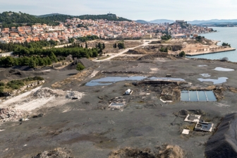
 Areal views of the eastern part of the project site
 Ground picture of the eastern part of the project site
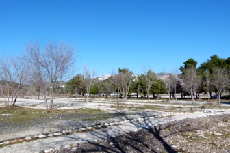
 Ground picture of the western part of the project site
Questions on the site
Hello, we were wondering if there is any specific buildable index for the project area of Šibenik. Thank you
In accordance to the General urban plan of Sibenik buildable index of this area is 0,3.
All the schemes are in croatian, is it possible to translate at least the legends in english?
The answer is posted in the "New_Docs_After_Launch" folder
Do you have a topographic plan of the underground of the site?
We don't have a topographic plan of the site's underground.
Do you have an analysis of the traffic from and towards the center? We would like to avoid a negative impact of the new circulation directions and sizes of the new roads on and around the site on the circulation in and out the city center.
You might find traffic load data in the Master Plan of Sustainable Urban Mobility of the City of Šibenik. Besides that, we have no other analysis.
The site boundary in the received site definition isn't the same as in the received ACAD files (HR-Sibenik-PS-M2) which boundary is the right one?
Only the land area of the project site is shown on the map "HR-Sibenik-PS-M2". Project site boundary (land and maritime area) is identical to the scope of the Urban development plan of mixed intended pupose zone Crnica (marked as: "UPU ZONE MJEŠTOVITE NAMJENE CRNICA") shown on map "HR-Sibenik-SS-M7".
Is there an inventory of the uses in the neighborhood of the site (commercial activities, business, schools, etc.)?
The answer is posted in the "New_Docs_After_Launch" folder
Are there specific needs for the establishment of small and middle-sized enterprises?
To our knowledge, there are no specific needs for the establishment of small and middle-sized enterprises.
Can you confirm that the whole site is included in the building zone? If not, is it possible to deliver a clear scheme illustrating which part is in the building zone?
Building areas are shown on maps "HR-SIbenik-C-M" and "HR-Sibenik-C-M2". According to the legends (scheme) they are marked with yellow colour, respectively Izgrađeni dio/neizgrađeni dio građevinskog područja naselja – built-up part/ non-built-up part of the building area of a settlement.
Only a small part of the site, designated for R6 purpose (beaches), shown on map "HR-Sibenik-S-M1" is not within the above mentioned area. But, according to Article 44 of Physical Planning Act (Official Gazette 153/13) beach development may be planned outside the building area.
This site is connected to the following theme
And productive again! How to Reintroduce the Productive Economy into New Urban Districts? Many formerly industrial places in and around cities are now out of use. Buildings were left in a derelict state, activities have been moved or stopped, sites became brownfields. Obsolescence is the common feature of these sites and the future is uncertain. Mostly, we dream of turning them into new vibrant urban quarters. But to avoid total gentrification as it has appeared many urban renewal projects in the past, we should perhaps try to put some productive activity in these sites… again? Because these sites were once industrial and linked to the city. Because there is a will for a really mixed city, and that mix includes productive economy as well.
How to Reintroduce the Productive Economy into New Urban Districts?
Questions on the site
You have to be connected –and therefore registered– to be able to ask a question.
Fr. 16 May 2025
Deadline for submitting questions
Fr. 30 May 2025
Deadline for answers
Before submitting a question, make sure it does not already appear in the FAQ.
Please ask questions on sites in the Sites section.
Please ask questions on rules in the Rules section.
If your question does not receive any answer in 10 days, check the FAQ to make sure the answer does not appear under another label or email the secretariat concerned by the question (national secretariat for the sites, European secretariat for the rules).