Charleroi (BE)
The Synthetic Site Folder and Site Brief are available for free.
Please register and login to access the Complete Site Folder.
- Synthetic site folder EN | FR
- Site Brief EN | FR
- Site on Google Maps
- Back to map
Data
Project scale XL/L - territory / urban + architecture
Location Charleroi, “Western Gate”
Population 201,327 inhabitants
Strategic site 199 ha - Project site 35 ha
Site proposed by City of Charleroi /Duferco Wallonie
Actors involved City of Charleroi /Duferco Wallonie
Owner of the site City of Charleroi /Duferco Wallonie
Commission after competition Urban planning and architectural study prior to the development
Team representative Architect
More Information
How can the site contribute to a productive city?
The City of Charleroi has traditionally built its economy on industry (steel-making, glass-making, mechanical engineering, etc.). It is also at the centre of a vast coal-mining basin (previously known as the “Black Country”). The decline of all these industrial activities gave way to vast sizeable areas of industrial blight that the City of Charleroi and Duferco Wallonie (the owner of the former “Carsid” industrial site) intend to redevelop. This reconversion will involve improvement of the built-up environment, tourism development alternatives and also an economic relaunch based on the establishment of companies and new industries. The “productive city” theme takes on its full meaning here.
City strategy
Charleroi has set up a master plan, whose effects will be increasingly felt, in which the unifying project of urban redevelopment is based in particular on regeneration of the “Marchienne-au-Pont” district, an essential part of the site, via a strategy of residential neighbourhoods that incorporate community urban functions, which have a positive knock-on effect on the heart of the former municipality deteriorated by the departure of industry.
The city authorities are envisaging the productive development of a landscaped park in which the challenge to be met is the collaborative neighbouring between the landscape and the industrial aspects, of which the image of heritage or resilient productivity will contribute to the sector’s appeal.
Site definition
The perimeter of the “Western Gate” mainly encompasses the municipalities of Marchienne-au-Pont and Monceau-sur-Sambre, situated to the west of Charleroi city centre. This perimeter is at the convergence of three valleys: Sambre, Eau d’Heure and Piéton stretching from Brussels to Charleroi.
The predominant aspect of the relief is the Sambre Valley and its broad alluvial plateau. This zone is a crossroads between the upper and lower Sambre Valley. Along the Charleroi-Brussels Canal, the varied relief of the slag heaps comprises a significant green backdrop.
How is production inserted in the urban diversity program?
In a previous study commissioned by Duferco Wallonie and led by a team mainly comprising geographers, urban planning architects and an expert in commercial town planning, the guiding principles of an urban strategy were drawn up: to revitalise new economic activities and commence an ambitious and broad-ranging urban redevelopment programme in an attractive landscaped setting.
The objectives are to preserve – or even amplify- the site’s economic purpose, increase density of employment, promote waste treatment and recycling systems, establish tertiary service.
In the mean-time, the City of Charleroi has tasked a working group with evaluating the site’s industrial heritage. This group is made up of city authority representatives (covering matters such as the city, regional planning and heritage), technicians and members of the support committee for saving “blast furnace 4”.
In addition to the indispensable “economic productivity” included in the Duferco plan, which is one of the essential ingredients of the site’s future, the city also intends to include “intangible productivity” by conciliating “economic stakes” with “cultural stakes”.
The former blast furnace, chimneys and industrial gantries are “bedrocks” of the landscape to be made use of and incorporated into the new setting, in order to maintain their interest in terms of history, architecture, aesthetics, social matters, landscaping and collective memory. “Green production” is also one of the stakes that the city wishes to promote, in particular via the creation of a green axis linking the site to the city and the extension of its soft mobility network, called “RAVeL”.
 Charleroi-Brussels canal
 North East of the study site
 Mons Street, N90
 Mons road N90 - « Rockerill »
Questions on the site
Can you clarify the difference between project site and strategic site?
Should we implement the masterplan program in the strategic zone or only work on the project site (is the strategic site only a context at work?)?
Example: could we invest the power plant outside the project site?
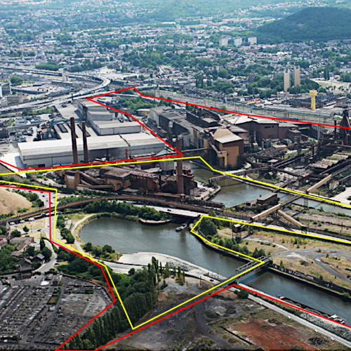
Europan has defined two sites:
A project site (yellow zone) on which candidates are asked to propose a urbanistic and architectural project based on the provided informations.
A strategic site (red zone) which places the project area in a wider environment, allowing on the one hand a better comprehension of the places in the spirit of a global reflection and on the other hand to be able to possibly propose developments or extensions on a larger scale.
Are there any readings and plans of the buildings, especially for the building of 12000 m? and the cooling tower?
No, we don't have plans for these buildings whose footprint is shown on the plans provided in the site file. The height of the cooling tower can be estimated at about 35 meters
However, we recall that Europan is above all a competition of ideas, and that the approximations (surfaces, heights, ...) will be tolerated by the jury who will judge rather innovative ideas rather than precise reproductions of the buildings.
Could you indicate to us where to find the reference document in the "brief": "CARSID: Pre-study for the valorization of the inheritance as part of the reallocation of the site", written by Chantal VINCENT?
This document has not been publicly disclosed. However, we tried in our Brief to extract the information closest to the reflection on the Europan site.
We saw that Europan published a video by drone in "Specific Documents". We can only visualize it in small screen, would it be possible to obtain it as a downloadable file?
The file seems much too heavy to transfer.
Here is another link for access to this video:
https://vimeo.com/320499991
How to get SPW plans via geoportal? A license is requested or, failing that, the authorization of a public owner. In the case of an individual approach this service is paid.
Geoportal site: unfortunately we have no other access than the one defined by the procedure imposed by the Walloon Region and which you indicate.
However, we have deposited in the site file a maximum of useful plans for your study.
With regard to the levels of pollution to which you could still have access on this site, we remind you that at the level of the competition of ideas that constitutes Europan, it is not necessary to enter in this type of study.
As indicated in the site visit report: It is not necessary to justify the process or the elements of the project through real profitability calculations in relation to the decontamination.
Is invariability of invariants relative or absolute? Indeed, in the site visit report, the so-called invariant walkways are declared subject to a demolition permit. Can this be clarified ?
The invariants noted in the Brief are the 3 chimneys, the 3 walkways and the blast furnace.
However, during the visit of the site, the Owner has indeed indicated that the walkways will be demolished because considered too old after recent verification (see site visit report)
You can therefore consider as absolute invariants: the 3 chimneys and the blast furnace.
Where will the decommissioning process be in 2020-2021?
The dismantling of the buildings will be completed in the area "Marcinelle" (South of the Sambre) at the end of 2021, with the exception of HF4 and its auxiliaries whose demolition was not authorized.
The "agglo" zone (North of the Sambre and East of the canal) will also be demolished at this horizon.
Finally, the date of demolition of the last infrastructures (between Sambre and canal) is unknown. Note that the TGV plant located in this area is a fairly recent investment (2012) whose life span will probably extend over more than 25 years.
Can you give us quantity and dimension information about the "Decayed Sculptures" discussed in the brief?
The city has not yet set an exact quantity. The sculptures have different sizes. It is therefore important to consider this element as an idea of spatial programming (but not structuring)
The Bellevue site is highlighted in several documents of the municipality of Charleroi. Is there any particular reason (historical, heritage, architectural ...)?
Is this site part of the demolitions planned by Duferco?
The Bellevue site (indexed "7" on the map of the Brief - p26) is located in the Northwest, inside the strategic site.
In order for the College to take a clear and thoughtful position on the future of the West Gate site, the Mayor and the Mayor of the Remarkable Heritage proposed to set up a working group of experts, whose main mission was to evaluate the potential of the industrial heritage of the West Gate.
This working group has indeed taken up again among various other places, the site of Bellevue as representing a historical, architectural and memorial interest and perhaps didactic in a new exploitation. However, it has not been taken as "invariant".
You are therefore free to integrate it or not in the design of your project
In addition, no date is set for a possible demolition.
We deposit some photos of this site in the site file.
This site is connected to the following theme
CHANGING METABOLISM CHANGING METABOLISM From linear to circular economy Characterized by a “linear”, obsolete or monofunctional economic approach, the site aspires to incorporate other resources and uses that create synergies and new potentials for interaction so that to create a circular system, catalysing flows and processes in a more integrative and efficient way.
From linear to circular economy
A new balance must be found between the relations, processes, flows and multiple forces of the sites that are large and contain a variety of agents (human and nonhuman) with long- and short-term cycles, and far-reaching ecological, economic and territorial implications.
Specific documents
Questions on the site
You have to be connected –and therefore registered– to be able to ask a question.
Fr. 16 May 2025
Deadline for submitting questions
Fr. 30 May 2025
Deadline for answers
Before submitting a question, make sure it does not already appear in the FAQ.
Please ask questions on sites in the Sites section.
Please ask questions on rules in the Rules section.
If your question does not receive any answer in 10 days, check the FAQ to make sure the answer does not appear under another label or email the secretariat concerned by the question (national secretariat for the sites, European secretariat for the rules).