Halmstad (SE)
The Synthetic Site Folder and Site Brief are available for free.
Please register and login to access the Complete Site Folder.
- Synthetic site folder EN
- Site Brief EN | SV
- Site on Google Maps
- Back to map
Data
Project scale L - urban + architecture
Location Halmstad, Central Station area
Population 100,000 inhabitants
Strategic site 180 ha - Project site 14 ha
Site proposed by City of Halmstad
Actors involved Trafikverket, Järnvägen, Municipality of Halmstad, Region Halland
Owner of the site Municipality of Halmstad
Commission after competition Detailed development plan and development of new Central Station
Team representative Architect - urbanist - landscaper
More Information
How can the site contribute to a productive city?
The competition task is to transform Halmstad Central Station area into the new hub of the city, through which the connections between national and regional, living and working, commuting and visiting serve as a catalyst for the urban development of the area. The aim is to expand the city centre eastwards to include this new productive area, and to link the segregated areas in the eastern and the western parts of the city. Halmstad Central Station area will be an integrated part of the city with new functions and increased connections to important focal points in the surroundings. The task is to strengthen the area’s urban qualities, to bridge the barriers of the railway, the main road and the river and to propose volumes and functions for a travel centre and other built structures. Innovative technical solutions for vibrations, traffic noise and rain water harvesting are sought for.
City strategy
The municipality of Halmstad is located along the West Coast railway line, a geographically favorable location between two of Sweden’s three major cities. The municipality strives to become a destination and a regional core in this dynamic line of growth. The development of the station area is an essential component in realizing this goal. Halmstad Central Station area should become an attractive node of transport and meeting place, a new point of interest easily accessible and well connected with its surroundings. The area should include attractive public spaces, green spaces and productive functions designed to promote social equality, sustainability and to strengthen the area’s urban qualities. To minimize the use of private cars the development will promote different sustainable modes of transportation.
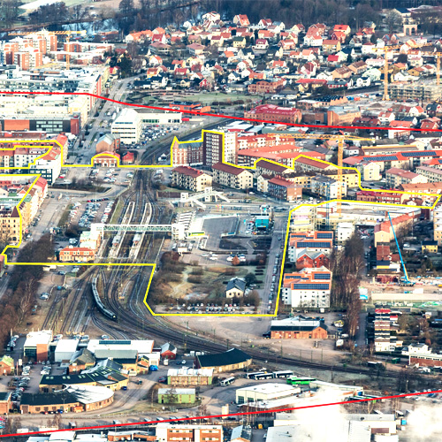
Site definition
The location of the site is central, but not in the immediate city centre. Barriers in form of the river Nissan, the railroad and the main road make the experience of distance longer than the physical. The northern part of the site contains two parking lots one on either side of the railway. The crossing in level with the railway will be closed for traffic and another alternative for pedestrians and cyclists will be designed. The area in the middle is the junction point where all modes of transportation interconnect. The regional and local bus stations have recently been relocated to this place, alongside two pedestrian bridges. An underpass under the railway connects Laholmsvägen to Viktoriagatan. The southern parts of the site include the existing railway station, and on the eastern side of the tracks a lawn and parking spaces.
How is production inserted in the urban diversity programme?
The location between two major growth areas; the Gothenburg region and the Öresund region, and the proximity to – from a business perspective – Northern Europe makes the city attractive for new business establishments. Halmstad is a famous summer resort, which combines beautiful beaches with an urban environment.
The development of Halmstad Central station area will establish a new cluster of movement focusing on pedestrians, bicyclists and public transportation. The strengthening of the area’s urban values will create a new dynamic in the area that links living quarters to important focal points, such as different hubs of commerce (city centre, Nyhem), culture (Österskans) and innovation (Halmstad University). Important workplaces in the surrounding area are the military, the hospital, the harbor and the industrial area Lars Frid. The integration of the site within the city, as well as the connection between important urban focal points will be strengthened and intensified when completed.
Halmstad Central Station area will become an important destination for arriving in the city, and will be the first impression of the city for most people visiting. Fully developed, the area will strengthen the municipality’s identity and become a memorable destination. Therefore, the design of the new buildings and their functionality is key. The station will be an important and diverse meeting point in the city and an attractive public space. The flow of people to, from, as well as through the station is important. Accessibility for all and sense of security are important aspects to consider when planning the future use of the area.
 The project site from the East: streetscape
 Current train station
 Train station and bus terminal
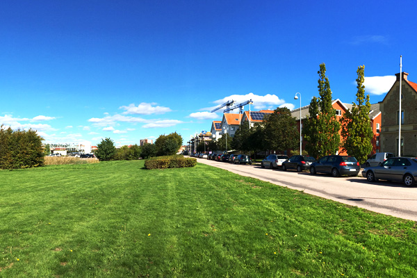 Southeastern part of the project site
Questions on the site
HALMSTAD: There are any specific fuctional program, numbers of buildings or meter square to follow? Or we are free to decide the program for the area?
Please see description under ”Competition task” within the competition brief. Number of buildings and amount of square meters is up to entrants to examine.
What is the needed height for a bridge crossing the rail tracks?
The free height above the rail tracks should be 6,5 meters.
At what height (meters above sea level) will the new platforms be and the rail tracks?
The height of the new platforms and the rails will not be changed. Please see the file SE-Halmstad-PS-M5 for existing heights of the platforms. The height measurements are shown in meters above sea level.
Hur skiljer sig fokus mellan det röda och gula tomtområdet? What is the difference in focus between the area marked with red and yellow?
The yellow line, the project site, delimitates the exact place on which the participants can propose a detailed project. The red line, the study site, delimitates the area that includes the whole context of the site, and allows a connection with the environment. Proposals for this area are allowed, but not asked for.
This site is connected to the following theme
CREATING PROXIMITIES CREATING PROXIMITIES Interfaces and short cycles
Interfaces and short cycles
In the physical space of the city, but also at temporal and actors' scales, it is about establishing proximities between living and working both within residential areas and between residential areas and monofunctional production zones. It is also about rethinking the transition between high-speed metropolitan mobility and the low speed of neighbourhoods.
The creation of interfaces contributes to the transformation of infrastructures of mobility, logistics, commerce or general services, by shortening production cycles, and generates new kinds of relations between residential and farming activities, between housing and services, between spaces and communities. Interface is a fluid space on incremental and adaptive processes, rejecting predefined master plans.
Specific documents
Questions on the site
You have to be connected –and therefore registered– to be able to ask a question.
Fr. 16 May 2025
Deadline for submitting questions
Fr. 30 May 2025
Deadline for answers
Before submitting a question, make sure it does not already appear in the FAQ.
Please ask questions on sites in the Sites section.
Please ask questions on rules in the Rules section.
If your question does not receive any answer in 10 days, check the FAQ to make sure the answer does not appear under another label or email the secretariat concerned by the question (national secretariat for the sites, European secretariat for the rules).