Marseille (FR)
The Synthetic Site Folder and Site Brief are available for free.
Please register and login to access the Complete Site Folder.
- Synthetic site folder EN | FR
- Site Brief EN | FR
- Site on Google Maps
- Back to map
Data
Project scale XL/S - territory / architecture + context
Location City of Marseille, La Cabucelle neighbourhood
Population Marseille 862,000 inhabitants. La Cabucelle 14 231 inhabitants
Strategic site 150 ha - Project site 90 ha
Site proposed by Marseille Rénovation Urbaine
Actors involved City of Marseille, AMP (Metropole Aix Marseille Provence), AGAM (urban planning agency)
Owner of the site City of Marseille, departement of Bouches du Rhône, state, social landlords, Region PACA, multiplicity of private actors
Commission after competition Urban and architectural feasibility study, mastery of urban and architectural work to initiate with operational partners
Team representative Architect - urbanist - landscaper
More Information
How can the site contribute to a productive city?
The Cabucelle reveals a mixed urban fabric that has been inherited from the port-industrial development of Marseille during the 19th and 20th centuries. This suburb district proves to be a true patchwork in which housing, offices, workshops, warehouses mingle together with various abandoned or serioulsy degraded parcels but also with more peaceful areas. Located in an important sector for metropolitan economic development (GPMM, Euroméditerrannée expansion, ZA Arnavants, ZFU...), the economic identity of the site remains dominated by unclear small logistical and handcraft activities. Which synergies can be identified between housing and economic activities, between functions and uses, between suburb districts and city centre districts ? Which diversities and vocations of the Cabucelle could be used to make it a resilient and welcoming urban space ?
City strategy
The Cabucelle is part of global approach of urban renewal that has been conducted by the municipality of Marseille with the main objectives of stopping permanently the process of decline and creating favourable conditions to economic development, housing diversification and improvement of living conditions to promote the social development of all. The Cabucelle is part of the urban policy neighbourhoods (« Quartiers Politiques de la Ville »). It is also one of the districts pending to be subjected to an urban renewal project. On the south fringe, the district will be impacted by the extension of Euroméditerranée (an Operation of National Interest – OIN) and the creation of a coastal joint development zone (ZAC). In the end, the site will benefit from the extension of the subway line 2 and of the tramway network. Ongoing studies will influence the future of the district, and should lead to a relevant urban renewal project that will convey actual developments.
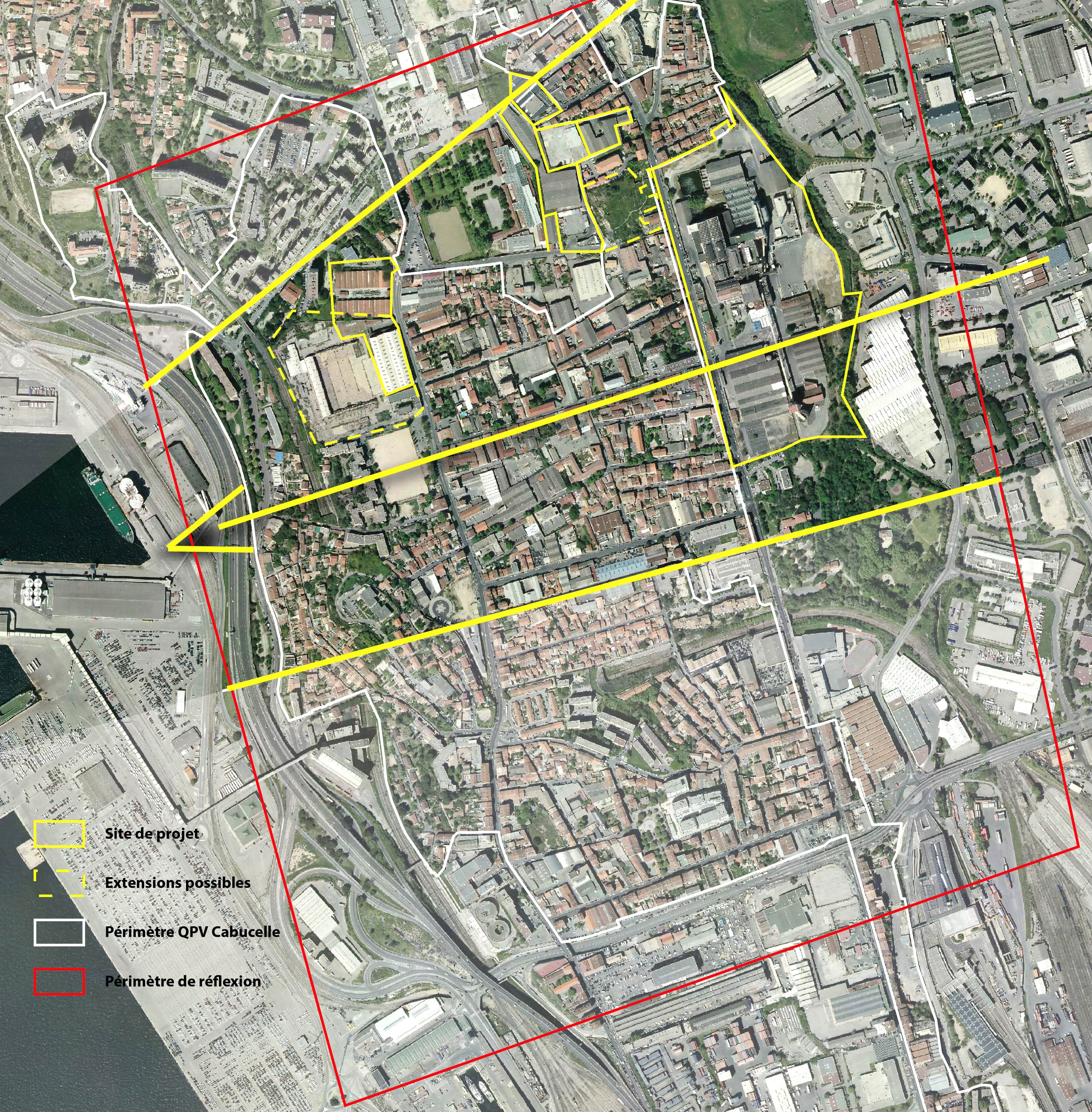
Site definition
The Cabucelle is a district from the 15th arrondissement of Marseille. It is bounded by Euroméditerranée to the South, by Saint Louis district to the North, by the seafront and the commercial port to the West and by the A7 highway to the East. Its main road is the Rue de Lyon. It is a fragmented sector with various urban forms (townhouses, warehouses from early 20th century, small collective buildings, areas of activity, wastelands, residential districts) that is characterised by a relative lack of centrality, an almost non-existent landscape framework and low access to public transport. The district is suffering from a negative image and a degraded socioeconomic situation : lack of equipments and public services, socioeconomic precariousness. Although it is one of the poorest districts of Marseille, the Cabucelle has land and social assets or resources linked to an economic and industrial tradition.
How is production inserted in the urban diversity programme?
The development of the Cabucelle will have to reconcile an economic and residential-social dual purpose. It will defend a vision of the productive city in terms of resource. The challenge is to reverse the viewpoint on this fragilised territory in order to see it from its assets perspective. It is assumed that there are material, human and/or conceptual resources, connected to this territory. The idea is to highlight other dynamics of creativity, solidarity ; to emphasize the invention of alternative solutions as vectors of socio-economic performance and social and spatial equity. The many challenges will aim at identifying and activating latent resources ; creating meeting spaces and diversity places ; having further connection between the territory and the metropolitan urban and economic dynamics ; improving the inhabitants’ living conditions and their movements by mobilizing all available levers. The candidates will have to work on an East-West sectional area from the activities zones of Arnavants/la Delorme to the autonomous bridge. This area will be punctuated by possible intervention sites (the Saint-Louis factory, the « Boues rouges » field (« the Aygalades heap »), the 287, the Madrague Ville way...) so that teams can bring their fresh and complementory perspective to urban and social study within the framework of the NPNRU prefiguration protocole.
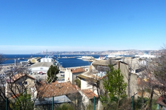 Sea view from La Cabucelle
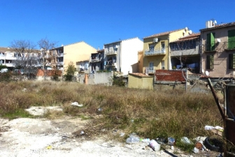 Wastelands and housings on the site
 View from La Madrague Ville way, on Cofrapex site
 Warehouses on Marseille Madrague-Plan
Questions on the site
Bonjour, Le dossier de site complet ne comprend pas de fichier dwg. Est t il prévu de nous communiquer ce document ?
Hello,
We have recovered the .dwg files related to the site.
They will ne available soon in the complete file (early next week).
Best regards
Is it possible to have a map of the site topography ? Thank you
Hello,
We have just recovered the .dwg files. They are available in the complete file.
Best regards
Bonjour, Nous voulions savoir si la transmission du fichier dwg du site est prévues? Si oui, pour quand? En vous remerciant d'avance pour vos réponses. Bien à vous. Faustine Vidberg
Hello,
We have just recovered the.dwg files related to the site. They will be available soon in the complete file (early next week).
Best regards
Hello, I just downloaded the new file of April 30th. You gave the DXFs. Are there any differences from the 5 April dxf ? Thanks in advance
Hello,
These are the same files that were delivered.
Best regards
Could you send us location plans of the industrial complex with their activities? Could you also specify which spaces are still in use today? Can you provide me with some answers, please?
. Cette question concerne-t'elle le site 3? A ce jour, l'ensemble du site est utilisé par son propriétaire, mais de manière peu dense. Il pourra s'agir de regrouper l'activité sur une partie de la parcelle, et de prévoir un phasage des évolutions du site. Nota: trois bâtiments sont classés dans le PLUi, au titre du patrimoine industriel. Merci.
Hello, Regarding DXF files, could you send us a legend for the layers? Thank you very much.
We made the request to the city of Marseille. We will upload this file as soon as we receive it.
Kind regards
Bonjour, Pourriez-vous mettre à jours le dossier complète avec la présentation nommée dans le report à la pag.6, les photos et le vidéo de la visite? erci pour votre collaboration.
The video of the Marseille site visit is now online, you will find the vimeo link on our Europan France website.
With kind regards.
Hello, I would like to know the nature and origin of the hill that is located north of the St. Louis sugar factory between the Aygalades stream and the 136-137 of the Avenue des Aygalades.
. The hill mentioned in the question is the registered plot 215905 H0138, nicknamed "Aygalades heap": this land is now unused because it is polluted by residues from the processing of bauxite to extract alumina. It is now owned by the City of Marseille, with considerations for a sale to a company. Note: due to this pollution, it is not a priori possible to plan daily uses or housing. The land is classified in the "basol" reference system managed by the State, which identifies polluted land. (the site doesn't seem to be working today). A website talks about this terrain, including http://pcdmq.blogspot.com/2011/05/sur-le-crassier-des-aygalades.html
Hello, I would like to know if there are any differences between the dxf given on April 15 and 30. So, between file 200 and file 1000 apart from the printing detail, what is the difference? Can you provide us with a legend for the layers for the 2 files? Not all of them are obvious. Thank you in advance for your collaboration.
The two dxf files are the same.
We ask the city for the layers and come back to you.
Hello, Unless I'm mistaken, in the complete file there is no detailed information on the railways in the area. Can you provide us with a plan with the connections and types of rail transport? Thank you for your cooperation.
Here are some sources that will identify the railways:
https://www.data.gouv.fr/fr/datasets/fichier-de-formes-des-lignes-du-reseau-ferre-national/
https://www.openstreetmap.org/#map=15/43.3349/5.3585&layers=T
Hello, I would like to know the nature and activity of the building which is located on plot K0071, northwest of site 2 and north of the CNAM PACA, on rue des freres Garniers-Pages opposite the private Catholic school St. Louis.
We made the request to the city of Marseille. We will download this file as soon as we receive it.
Hello, While observing the PLU, we noticed that several retention basins, such as 28-PR5 equipment, are planned in the Saint-Louis ZAC on Ledru Rollin Boulevard and 37-R41 equipment in the Saint-Louis Sugar Mill Park. Can you explain the reason? We thank you in advance.
The Cabucelle sector is impacted by the PPRI of the Aygalades Creek: which entails significant constraints in terms of constructibility, and involves the creation of retaining basins to reduce downstream.
While observing the PLU, we noticed that several retention basins, such as 28-PR5 equipment, are planned in the Saint Louis ZAC on Ledru Rollin Boulevard and 37-R41 equipment in the Saint Louis sugar factory grounds. Can you explain the reason? Thank you in advance.
The Cabucelle sector is impacted by the PPRI of the Aygalades Creek: which entails significant constraints in terms of constructibility, and involves the creation of retaining basins to reduce downstream.
On the report of the visit of the site, it is metionnée a presentation file in ppt with the economic stakes of the city of Marseille. Can you make it available to us? Thank you,
Hello, This document has just been added to the complete file, which you can re-download. Best regards
Is it possible to have more information on the level of business activity of the site Saint Louis, especially if there are parts / buildings on this site currently not used?
Today, the entire site is used by its owner, but in a rather sparse manner. It could be to regroup the activity on a part of the plot, and to plan a phasing of the evolutions of the site. Three buildings are classified in the PLUi, as industrial heritage.
Is it possible to have interior photos and / or plans of the buildings located on the site 1 - Warehouse city of Marseille madrague plan - buildings Cofrapex baccuet (extension site) Thank you
- Warehouse city of Marseille madrague plan:
there are no photos, but the inside of the building was filmed during the visit:
it is possible to refer to the film put online by Europan,
- buildings Cofrapex baccuet (extension site): we do not have the plans of the buildings
(question asked to the land service of the City); some additional photos have been added to the complete file.
On the Madrague Plan site, can you tell us what is in the white warehouse south of the warehouses currently used by the public lighting maintenance department? Is this also a storage for this purpose? What is the condition of this building?
Hello,
This is the "bacuet" warehouse: it is not currently used by the City; it is empty and squatted, the structure of the building and the floors are solid, but the whole building is to be renovated. Photos have been added to the complete file, you can download it again.
Best regards
Does the city completely exclude a residential use on the possible extension of Madrague's port-oriented plan?
An opening to a residential use could be done only in a very framed way and in complement of activities.
Are the Madirosan site buildings empty? If not, what is the city currently storing?
Some of these warehouses are used for the storage of garbage trucks: see the photos added to the complete file entitled "parcel K15" and K42. You can redownload the folder.
This site is connected to the following theme
CHANGING METABOLISM CHANGING METABOLISM Multiplying and connecting agencies
Multiplying and connecting agencies
A new balance must be found between the relations, processes, flows and multiple forces of the sites that are large and contain a variety of agents (human and nonhuman) with long- and short-term cycles, and far-reaching ecological, economic and territorial implications.
By defining and connecting the future agencies regarding air, water, soil, flood, programmes, activities and users, and new layers of functions, it may lead to a balanced growth on these sites. The final design will be something more than the sum of circular urban economies.
Specific documents
Questions on the site
You have to be connected –and therefore registered– to be able to ask a question.
Fr. 16 May 2025
Deadline for submitting questions
Fr. 30 May 2025
Deadline for answers
Before submitting a question, make sure it does not already appear in the FAQ.
Please ask questions on sites in the Sites section.
Please ask questions on rules in the Rules section.
If your question does not receive any answer in 10 days, check the FAQ to make sure the answer does not appear under another label or email the secretariat concerned by the question (national secretariat for the sites, European secretariat for the rules).