Rochefort Océan (FR)
The Synthetic Site Folder and Site Brief are available for free.
Please register and login to access the Complete Site Folder.
- Synthetic site folder EN | FR
- Site Brief EN | FR
- Site on Google Maps
- Back to map
Data
Project scale XL/L - territory / urban + architecture
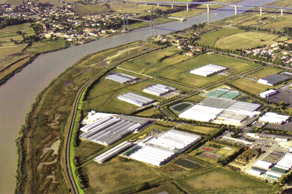
Location The strategic site concerns three communities (Rochefort-sur-Mer, Echillais, Saint Hyppolyte), project sites are in one community
Population Rochefort 25,000 inhabitants (approx.), 3 communities 30,000 inhabitants
Strategic site 940 ha - Project site 4 sites from 10 to 40 ha
Site proposed by Rochefort Océan inter-communal area, the city of Rochefort, Syndicat Mixte du Port de Commerce (joint public venture), STELIA Aerospace
Actors involved Rochefort Océan inter-communal area, the city of Rochefort, commercial port, STELIA Aerospace and the government
Owner of the site Rochefort Océan inter-communal area, the city of Rochefort, Syndicat Mixte du Port de Commerce (joint public venture), STELIA Aerospace and the government
Commission after competition Landscape analysis of the study site; urban analyses and development programmes for the project sites.
Team representative Architect - urbanist - landscaper
More Information
How can the site contribute to a productive city?
The city of Rochefort-sur-Mer, founded in 1666 by Charles Colbert du Terron in marshlands, gave the Kingdom of France a port for the construction of its military fleet. This activity remained the driving economic force in the territory until the Arsenal was closed in 1927. However, an economy related to navigation and military needs has continued with production activities related to maritime commerce and aeronautics. In addition, an outstanding architectural and urban planning uniformity as well as remarkable buildings (i.e. Corderie Royale) within proximity of exceptional natural sites has allowed the city to develop a significant tourist trade. The four project sites are oriented towards the river and were in activity when the Arsenal was still functioning. Whether currently in full activity or partial, the goal is to allow their transformation within the framework of an exceptional geographic, environmental and architectural heritage while taking into consideration the risks from flooding of the meandering Charente River.
Inter-Communal strategy
In order to maintain and develop territorial production, the Rochefort Océan inter-communal area has begun several ambitious development projects for three strategic cornerstones of the economy: industry (currently 20% of jobs), logistics (commercial port development) and tourism (natural and architectural qualities of the territory). This is taking place mainly on three large-scale operations located along the Charente River: a tourist project on the former Arsenal site, an extension and reorganisation of the Arsenal industrial zone and an extension to the commercial port. For these sites to evolve over long-term, better integrate their natural and built heritage and anticipate the effects of flooding similar to those of cyclone Xynthia, the Rochefort Océan inter-communal area is looking for resourceful, innovative solutions for the following four sites: Arsenal industrial zone, commercial port, a small park and a horticultural area.
Site definition
The strategic site runs along the Charente from the transporter bridge to the suspension bridge, each of these connecting the two banks of the river. This site includes:
- On the right bank, from west to east: the Martrouts retail area, Fourrier business park, historic town centre of Rochefort, the railway station, marina, commercial port, Vacherie business park and single-family housing on the edge of town, then a nature area that extends to Quai de la Liberation in Tonnay Charente, the historic town centre of Tonnay Charente and finally single-family houses to the suspension bridge.
- On the left bank, from east to west: the suspension bridge, a site that includes vast marshlands, as well as an old pit for storing masts in salt-water pools and finally an area of single-family houses near the transporter bridge.
How is production inserted in the urban diversity programme?
Productive areas that anticipate flooding
The risk of flooding needs to be evaluated over the entire study site and more specifically on the individual project sites where technical solutions are needed to control rising waters and/or productive activities found that are compatible with coastal flooding.
Use the architectural, geographical and environmental heritage as a resource for productive areas
How can a project site’s heritage be used to benefit the site and its productive activities while remaining coherent with the entire study site? The challenge is to take a site’s heritage and make it a «living» heritage focusing on uses compatible and coherent with the site’s activity.
Increase permeability between a working and a living city
Although the industrial sites need to be closed to public for security reasons, visual and functional links between these «working» and «living» areas are excessively limited despite their proximity. What physical, visual and functional connections could exist between the sites and their immediate environment?
Use mobility to connect sites
All the sites have parking and traffic issues. Europan competition is an opportunity to investigate new types of access and medium-term solutions to these problems. Beyond this functional aspect, it is also an opportunity to question how to reinforce connections between sites.
 Project site 1: commercial port
 Project site 2: the small park
 Project site 3: Arsenal industrial zone
 Project site 4: the horticultural area
Questions on the site
Bonjour, quand sera-t-il possible d'avoir accès à un fichier cartographique (format dxf ou autre) servant de base à nos réflexions et dessins de projet ?
Hello,
We have just recovered the.dwg files related to the site. They will be soon available in the complete file (early next week).
Best regards
Hello, In the brief you mention that for the Commercial Port and the ZAC de l'Arsenal community has already begun work and wishes for visions and strategies for thos site. Would it be possible to have some documentation of this process (and their outcome, in any) ?
Bonjour,
Le Port de Commerce a entamé une réflexion qui a donné lieu en 2016 à un schéma d'aménagement économique de la zone portuaire en 3 étapes :
- 2016-2020 : organisation de la gouvernance, acquisitions foncières
- 2020-2025 : augmentation de la capacité du port (+20 300 m2 SDP)
- 2025-2030 : intensification avec densification (+ 22 100 m2 SDP) et poursuite du renouvellement de l'existant.
Le Port de Commerce dispose aujourd'hui d'un plan d'aménagement, qui peut être réinterrogé dans sa forme, mais pas dans ses fonctions (décrites dans le dossier de site).
Concernant la ZAC de l'Arsenal, une étude urbaine préalable a été réalisée, ainsi qu'une première esquisse. La collectivité vient de désigner l'aménageur de la ZAC. Ce plan peut être réinterrogé dans sa forme urbaine.
Bien cordialement
Bonjour - Among the files made available post launch certain ones cannot be downloaded. Could you please let us know how to access them/ fix this error? Many thanks.
We are aware of the problem and are doing our best to fix it. By the weekend this should be settled.
Would it be possible to have a more detailed plan of the arsenal showing (i) location of companies, (ii) private vs public areas, (iii) areas closed-off to public for safety and other reasons, (iv) ZAC area?
Hello,
The following plans will provide you with the requested information :
- Location of businesses and ZAC area : FR-ROCHEFORT-PS3-M4-Carte des occupations
- Private and Public areas : FR-ROCHEFORT-PS3-M3-Carte des propriétés foncières
- Areas closed to the public for security reasons and other : the area closed to the public corresponds on the map
« FR-ROCHEFORT-PS3-M3-Carte des propriétés foncières » to that representated by the caption « Propriétaires privés (activités aéronautiques) », which corresponds to the STELIA aerospace rights of way.
Best regards
Hello, would you be able to provide us with an occupation scheme including the names of the companies? Many thanks.
Hello, plans indicating occupants are available in the appendices of the site file:
- For the commercial port: FR-ROCHEFORT-PS1-M2-Occupation et maîtrise foncière;
- For the Petit Parc: no occupation plan available
- For the Arsenal ZAC: FR-ROCHEFORT-PS3-M4
- Carte des occupations: For the horticultural zone: FR-ROCHEFORT-PS4-M2-Occupation
Hello, in the complete site folder some documents remain impossible to download: - PS1-M2-Occupation and control of land - PS1-M3-Draft development project - PS3-M3-Map of land properties - PS3-Presentation of Stelia - SS-M14-Submersion protection system
We are doing our best to fix the problem. By the weekend this should be settled.
In the Journal of the city we found a infographic indicating the city budget for 2019. There are no indications on parts being spent on the Port de Commerce or Le Arsenal. Are there other budgets and how high might they be in 2020-2024?
Hello,
We have added the financial breakdown of the port layout plan in the Rochefort / Tonnay-Charente complete file. Funding for the project is being discussed with the various partners, which are: State, Region, Department, Community of Agglomeration, City of Rochefort, City of Tonnay-Charente and Syndicat Mixte. It is difficult for me to provide more details.
Best regards
This site is connected to the following theme
CHANGING METABOLISM CHANGING METABOLISM From linear to circular economy Characterized by a “linear”, obsolete or monofunctional economic approach, the site aspires to incorporate other resources and uses that create synergies and new potentials for interaction so that to create a circular system, catalysing flows and processes in a more integrative and efficient way.
From linear to circular economy
A new balance must be found between the relations, processes, flows and multiple forces of the sites that are large and contain a variety of agents (human and nonhuman) with long- and short-term cycles, and far-reaching ecological, economic and territorial implications.
Specific documents
Questions on the site
You have to be connected –and therefore registered– to be able to ask a question.
Fr. 16 May 2025
Deadline for submitting questions
Fr. 30 May 2025
Deadline for answers
Before submitting a question, make sure it does not already appear in the FAQ.
Please ask questions on sites in the Sites section.
Please ask questions on rules in the Rules section.
If your question does not receive any answer in 10 days, check the FAQ to make sure the answer does not appear under another label or email the secretariat concerned by the question (national secretariat for the sites, European secretariat for the rules).