Rødberg (NO)
The Synthetic Site Folder and Site Brief are available for free.
Please register and login to access the Complete Site Folder.
- Synthetic site folder EN
- Site Brief EN
- Site on Google Maps
- Back to map
Data
Project scale XL/L territory / urban + architecture
Location Rødberg, Nore og Uvdal municipality
Population Rødberg 502 inhabitants; Nore og Uvdal 2,482 inhabitants; up to 20,000 inhabitants in the high season
Strategic site 110 ha - Project site 28 ha
Site proposed by Municipality of Nore og Uvdal
Actors involved Municipality of Nore og Uvdal
Owner of the site Municipality and private owners
Commission after competition Planning and/or building commission
Team representative Architect - urbanist - landscaper
More Information
How can the site contribute to a productive city?
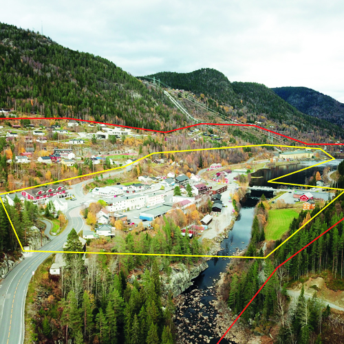
Rødberg is located between the historic rural centres ‘Nore’ and ‘Uvdal’. It is very much defined by its significant hydropower production plant, implemented in the 1920s. Before the hydropower development, the entire Numedal was a farming and woodland region. Hydropower production, farming and tourism now dominate the local economy. The hydropower plant Nore I is located in Rødberg, while the farmland areas are distributed along the Numedal valley.
‘Nore og Uvdal’ is a popular tourist destination, hosting 4000 second-homes counting up to 20.000 second-home dwellers during weekends and holidays. This has nevertheless a limited impact on the economy of Rødberg, which has not succeeded in creating attractions for the leisure time population of the area. How can Rødberg develop more attractivity both for local residents, second home dwellers, investors and entrepreneurs?
City strategy
Rødberg developed from a settlement of two farms into an industrial community and is today the administrative and commercial centre of Nore og Uvdal. Despite a growing number of second home dwellers, Nore og Uvdal is facing a decline in its permanent population. Skilful coordination of local production, assisted by technology and investment definitely has potential for lifting Rødberg to a level of more dynamism in terms of economic and social productivity.
Rødberg must release a new strategy for advertising its hidden potential and unique resources where the rural and urban overlap. Nore og Uvdal municipality has a solid economy and political will to implement such a strategy for a more prosperous and attractive Rødberg.
Site definition
The centre of Rødberg has a west-east orientation in the valley of Numedal. Rødberg is situated along the bottom of the valley. Its commercial centre is a strip development along the county main road west of the bridge. The hillside facing south is developed to a housing area with public community services.
The village is concluded to the east by the monumental power station Nore I, from 1928, with old pen gates coming down the mountainside.
The Rødberg Dam holds the water reservoir for the hydropower plants Gvammen and Nore II further south in Numedal. The power station and its facilities, including the remains of the railroad, make a powerful imprint on Rødberg.
The railroad, including the bridge across Uvdalsåe and all associated facilities, are protected as listed historic monuments.
How is production inserted in the urban diversity programme?
Uvdal, Rødberg, Nore and Tunhovd are the four villages that constitute the municipality of Nore og Uvdal, which covers a vast territory. Numedal leads south to Kongsberg, 1.5-hour drive away. Next to Kongsberg, Rødberg is the largest settlement in Numedal and the last trading point for second-home dwellers going to the mountain areas.
The municipality of Nore og Uvdal is part of the partnership “Kongsberg Region” which focuses on creating a common digital service network for the cooperating partners. The city of Kongsberg is currently developing a system of self-driving public transport.
The County Council of Buskerud has launched the idea of a green corridor through the valley of Numedal, including charging stations for electric cars. One of the charging stations is located next to the supermarket in Rødberg, making it an attractive spot for second-home dwellers on their way to the mountains where nature and wildlife are highly valued qualities.
Can a strategy that connects Rødberg to the productive territory reverse the decline of the trading industry along the county road, put new life into empty premises and give life to the town centre? Can primary industries be gathered and structured in a network that emphasizes Rødberg as the municipality centre and strengthens the relationship between the villages in the municipality, and the region of Kongsberg? How can Rødberg take advantage of these synergies? Can Europan propose and visualize a strategy for how to obtain a more dynamic town centre in terms of economic and social productiveness?
The ambition should frame a forerunner in the movement towards a sustainable future in rapid change.
 Leisure park, railway facilities and Rødberg school
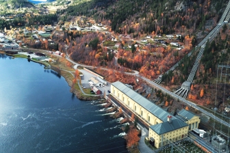 Hydro-power plant Nore 1
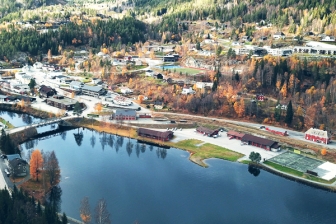
 Down town Rødberg
 Train turnable & railway depot
Questions on the site
What is the function of building S? Can the whole building Solvang be re-purposed? How many floors does Sentrum 14 and is the ground floor considered the 1º floor or 0? What activities can be done in the dam? Is the ceiling height of the food processing plant the minimum or a fixed requirement? Are there more available pictures of buildings W/U ?
What is the function of building S?
As it is stated in the map on page 14 of the brief, the building is the old railway station on the ‘Numedal Railway Line’, built for the purpose of transporting construction materials to Nore I, although the station closed on 1988/1989.
On page 17 of the Brief you can find a short description:
“The station buildings are renovated and hold several rental apartments and premises the company ‘Numedal produksjon’ (Numedal production). This is a small production area with an affiliated shop. (...) . “ Also, according to the owner of the building -Bane Nor- “the outhouse at Rødberg Station is rented to a local brewery.”
Can the whole building Solvang be repurposed?
The municipality does not have an independent plan for the building, but the owner has stated its wish for the building to be programmed in the selected floor. It is up to the contestants to decide whether to tackle the selected floor or the whole building depending on the role that it plays in their overall spatial plan as a whole. But in the end, it will be the municipality the one who decides what strategy to follow when looking at the bigger picture.
How many floors does Sentrum 14 and is the ground floor considered the 1º floor or 0?
Sentrum 14 is a 4th storey building. It is described according to the Norwegian standards in which the ground floor referred to as 1st floor. So you could say that the building has a 1st floor/ground floor plus three other floors.
What activities can be done in the dam?
Rødbergdammen is a water reservoir for power production. The dam stores water from both Uvdalselva river and the outlet water from the Nore I hydropower plant. It is up to the contestants whether to make some proposals depending on the role of the dam in their overall spatial plan.
Is the ceiling height of the food processing plant the minimum or a fixed requirement?
It is a minimum. As stated on page 23 of the Brief “The processing plant should preferably be scalable and requires a minimum area of 280 m2 with a ceiling height of 3,5 meters.”
Are there more available pictures of buildings W/U ?
No, all of the pictures related to these buildings are already uploaded to the complete site folder. But here are the code-names:
NO-Roedberg-SS-AP3
NO-Roedberg-SS-AP8
NO-Roedberg-SS-AP9
NO-Roedberg-SS-AP13….AP16
NO-Roedberg-PS-P57
NO-Roedberg-PS-P58
This site is connected to the following theme
CREATING PROXIMITIES CREATING PROXIMITIES Third spaces in-between
Third spaces in-between
In the physical space of the city, but also at temporal and actors' scales, it is about establishing proximities between living and working both within residential areas and between residential areas and monofunctional production zones. It is also about rethinking the transition between high-speed metropolitan mobility and the low speed of neighbourhoods.
A third space is a new space inserted between housing and production areas that can catalyse the transformation of current production cycles by creating synergies with urban territories and everyday life. It can be located in residual spaces within neighbourhoods, between existing monofunctional zones or emerge from recycled urban fabric.
Specific documents
Questions on the site
You have to be connected –and therefore registered– to be able to ask a question.
Fr. 16 May 2025
Deadline for submitting questions
Fr. 30 May 2025
Deadline for answers
Before submitting a question, make sure it does not already appear in the FAQ.
Please ask questions on sites in the Sites section.
Please ask questions on rules in the Rules section.
If your question does not receive any answer in 10 days, check the FAQ to make sure the answer does not appear under another label or email the secretariat concerned by the question (national secretariat for the sites, European secretariat for the rules).