Romainville (FR)
The Synthetic Site Folder and Site Brief are available for free.
Please register and login to access the Complete Site Folder.
- Synthetic site folder EN | FR
- Site Brief EN | FR
- Site on Google Maps
- Back to map
Data

Project scale L - urban + architecture
Location City of Romainville, Ormes and Chemin Vert neighbourhoods
Population Romainville 26,000 inhabitants, Est Ensemble 408,000 inhabitants
Strategic site 15 ha - Project site 2.7 ha
Site proposed by City of Romainville
Actors involved City, Est Ensemble, Department 93, Etablissement public foncier d’Ile-de-France (EPFIF), IDF Region, State
Owner of the site City of Romainville, Department 93
Commission after competition Urban development guide, orientation scheme, architectural intervention
Team representative Architect - urbanist - landscaper
More Information
How can the site contribute to a productive city?
In the southern part of the city, near the A3 highway and the remnants of an obsolete road infrastructure, the site, an abandoned urban area awaiting the arrival of the tramway (T1), creates a tremendous opportunity for the development of a new «piece of the city» connected to the city centre and combining new forms of urban activity (business premises, urban logistics, etc.) associated with a housing programme promoting the emergence of new uses and public facilities. Favoured by the arrival of new tramway (T1), this territory, which is currently isolated, must be able to develop synergies that link it to other centres in the eastern metropolitan area (Montreuil, Noisy-le-Sec, Fontenay-sous- Bois.) and create greater territorial equity.
City strategy
The city has a voluntary policy that favours co-construction, biodiversity and nature in the city. It is a forerunner in urban agriculture with the Cité Maraîchère project and is active in raising awareness and pedagogy. The city places a priority on its social-housing neighbourhoods, seeking to develop diversity in housing and activities. It has a strong political desire to develop land management tools in partnership with the EPFIF (Public Property Establishment Ile-de-France) to ensure architectural and environmental quality in housing programs but also social and functional diversity by developing private-public partnerships. Romainville wishes to pursue an innovative, experimental approach with the population and is looking for a theme that would bring together areas of production, training, distribution and exchange as well as residential areas.
Site definition
Bordering on the city of Montreuil and therefore at the entry to Romainville, the project site is an area of urban neglect and abandoned heavy road infrastructures that will disappear with the construction of the T1 tramline (start of the work in 2019) linking Bobigny to Val de Fontenay. The abandoned A186 motorway and surrounding plots of land generate about 10 ha of land in Montreuil and Romainville, 2.7 hectares are in Romainville.
If the A3 motorway, a small stretch of which is covered over further north, creates a strong rupture in the landscape and is a source of nuisance (pollution, noise) it also presents a major advantage for the site and elicits urban logistic potentials. It is a neighbourhood of small business buildings and collective housing that needs to prepare for the arrival of the tramway and an end to its isolation. The current fabric has a functional and social diversity that is important to maintain and exploit. The neighbourhood of local artisan workshops, single-family houses and apartment blocks needs to be strengthened, energized, woven together and diversified.
How is production inserted in the urban diversity programme?
Along the T1 tramway, new building programmes should encourage more of the diversity already present on the site (activities, services, training, etc.) and produce housing typologies for a variety of needs and expectations that will come with new inhabitants. The site presents a real opportunity to connect two sectors of the city and develop territorial continuity while also creating an urban planning around the tram stop «Libre pensée». Programme and spatial considerations need to initiate a transformation process that will connect this territory to the rest of the city and Montreuil. How best to bring activities, services, public facilities and housing to this abandoned area and connect it to the rest of the city while still satisfying the need for «nature in the city»? The A3 motorway allows the programming of new activities (urban logistics / circular economy) that serve new local connections.
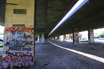
 A186 highway, infrastructure to destroy
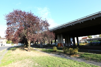
 Project site below the A186 highway
 Gallieni street, support for the future T1
 Ormes neighbourhood
Questions on the site
Hello, Following the exchange at the Europan visit in Romainville, we had confirmation by the city of the availability of .dwg files related to the site. Would it be possible to access it soon in the complete file ? Thank you
Hello,
We have just recovered the .dwh files related to the site. They are available in the complete file.
Best regards
Hello, Is it possible to obtain details on the budget and temporality (phasage) of demolition work on the A186 viaduct ? Best regards
Hello,
Documents on this subject have been added to the complete file. You can download it again for access.
Best regards
Hello, is it possible to obtain a topographic document covering the Romainville intervention site ? Thank you.
Hello,
We have just recovered the .dwg files related to the site. They are available in the complete file.
Best regards
Hello, After having consulted the whole file of the Romainville site, i can not find the new tracks with the deletions of the A3 and the A186 motorway bridges. Best regards
Hello,
Documents on this subject have been added to the complete file. You can download if again for access.
Best regards
Hello, Is it possible to have more material about the infrastructure A186? In particular, plans and / or sections of the actual situation for the entire length, partially already loaded on April 15, 2019 only for the northern part where it attaches the highway A3 (file: cdb_T1_total_06_02_2013_2D). Thank you
We made the request to the city of Romainville. We will download this file as soon as we receive it.
Hello, Is there any 3D data available? or a Topo survey? Kind regards,
We made the request to the city of Romainville. We will upload this file as soon as we receive it.
Is it possible to have the missing xref files, linked to the dwg files that have been transmitted (T1E-IU93-PNI-P62-6252-AVP-PL00000-DAB-012200-A01(SANITATION).dwg and T1E-IU93-PNI-P62-6210-AVP-PLA0000-DEV-012100-A06(AMENAGEMENT).dwg?
Hello,
DWG files with xref were added this morning. You can download the complete file on the Europan Europe website for access.
Best regards
Will the A3 exit from Paris to the A186 (incised road) be completely or partially backfilled during the demolition work on the interchange?
We are doing our best to find an answer to fix the problem. By the weekend this should be settled.
Hello, Is there any Master Plan's Romanville (.dwg) and 3D (.Skp) files? Thank you !
Hello,
DWG files with xref were added this morning. You can download the complete file on the Europan Europe website for access.
Best regards
Will the exit of the A3 from Paris and to the A186 (entered road) be completely or partially backfilled during the demolition work on the interchange? (the first answer given by Europan seems off topic)
A priori this output will be backfilled, the city of Romainville checks.
Are the mutable land rights of way (p.22 site file) defined in the actual capacities of the site and by the T1 tramway project fixed or can they be adapted?
The indicated land is to be treated of course. An analysis of the surrounding land mutabilities can make it possible, by arguing, to give orientations or proposals on a wider perimeter, but taking into account that there is no desire to transfer the suburban areas (do not encourage mutation by real estate promotion) on houses
Is it possible to rethink the position of the connection between boulevard Edouard Branly and the T1 axis, located north of the Rue de la Libre pensée?
No, it isn't possible.
Do you have more specific construction objectives than those stated in the brief (R + 5-6 front of the tramway)?
No, we do not have more specific constructability goals. It is necessary to argue your ideas according to the analysis of the territory. On the other hand, the Mayor is committed to the projects being presented and accepted by the inhabitants
Is the sports equipment registered in the program defined? Do you have an accurate, established or desired programming that can be communicated?
There is no precise programming, the goal is to have a versatile equipment that can accommodate various disciplines
Has a soil pollution study been carried out on this sector? Is it possible to read it? is a land use strategy established or is it desirable in the proposals for rendering?
No pollution study has been done but studies will be needed before any type of construction.
Has a fauna / flora diagnosis been made on this site supporting a strong plant presence?
There has been no diagnosis of fauna / flora made to our knowledge, we can inquire from Est Ensemble.
Is the sports equipment registered in the program defined? Do you have an accurate, established or desired programming that can be communicated?
We have no precise programming, we opted for a versatile equipment that can accommodate various disciplines.
This site is connected to the following theme
CREATING PROXIMITIES CREATING PROXIMITIES Interfaces and short cycles
Interfaces and short cycles
In the physical space of the city, but also at temporal and actors' scales, it is about establishing proximities between living and working both within residential areas and between residential areas and monofunctional production zones. It is also about rethinking the transition between high-speed metropolitan mobility and the low speed of neighbourhoods.
The creation of interfaces contributes to the transformation of infrastructures of mobility, logistics, commerce or general services, by shortening production cycles, and generates new kinds of relations between residential and farming activities, between housing and services, between spaces and communities. Interface is a fluid space on incremental and adaptive processes, rejecting predefined master plans.
Specific documents
Questions on the site
You have to be connected –and therefore registered– to be able to ask a question.
Fr. 16 May 2025
Deadline for submitting questions
Fr. 30 May 2025
Deadline for answers
Before submitting a question, make sure it does not already appear in the FAQ.
Please ask questions on sites in the Sites section.
Please ask questions on rules in the Rules section.
If your question does not receive any answer in 10 days, check the FAQ to make sure the answer does not appear under another label or email the secretariat concerned by the question (national secretariat for the sites, European secretariat for the rules).