Rotterdam Kop Dakpark (NL)
The Synthetic Site Folder and Site Brief are available for free.
Please register and login to access the Complete Site Folder.
- Synthetic site folder EN
- Site Brief EN
- Site on Google Maps
- Back to map
Data
Project scale L/S - urban + architecture / architecture + context
Location Rotterdam, Marconiplein, Kop Dakpark
Population 650,000 inhabitants
Strategic site 20.4 ha – Project 1.1 ha
Site proposed by Municipality of Rotterdam
Actors involved Municipality of Rotterdam, St. Dakpark, Groene Connectie, Delfshaven Coöperatie, winkeliersver. Bigshops
Owner of the site Public and private ownership
Commission after competition Design (or research-by- design) assignment on implementation on the project site (or a site with similar characteristics) commissioned by the municipality of Rotterdam and/or private partners
Team representative Architect - urbanist - landscaper
More Information
How can the site contribute to a productive city?
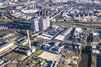
The construction of the Merwe-Vierhavens (M4H) was accompanied by the construction of the working-class neighbourhoods Bospolder to accommodate the dock workers. The initial reciprocity between the port and these neighbourhood has now ceased to exist. In areas like M4H, traditional industry is being replaced by the next economy, while residents in the surrounding neighbourhoods are struggling to keep up. The new building block on the plot at the beginning of the ‘Dakpark’ (=rooftop park) – inserting work-homes for different generations and income brackets – should restore the social and economic connections and become the missing link between the old and the new economy, between blue-collar and white-collar labourers, between living and working.
City strategy
The City of Rotterdam seeks opportunities to accommodate its growth in the existing city. Densification of urban voids, in particular the ones near a public transport hub, with a strategic position in the city is part of this strategy. This type of development is ideally suited to catalyse new interaction milieus, since it offers the opportunity to implement a new work-and-live programme connecting citizens with all sorts of backgrounds, knowledge and skills, various (economic) activities and other ‘resources’ that are already present in the surroundings. Especially urban voids that are at the intersection of multiple neighbourhoods with diverse urban dynamics, like the plot at the beginning of the ‘Dakpark’, offer unorthodox anchors for such productive milieus.
Site definition
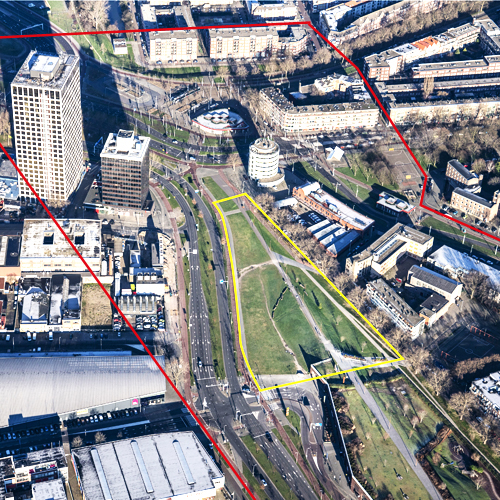
The project site is an urban void situated in western Rotterdam next to the Marconiplein, an important public transport hub and gate to the inner city. It is at the intersection of several residential areas originally planned for the working classes – Bospolder, Tussendijken, Spangen and the Witte Dorp – and the port area M4H that is being transformed into an innovative makers district. Between M4H and Bospolder there is the ‘Strip’, an elongated building with a range of large chain stores and a lively communal park on top. The challenge is to develop a radical spatial intervention on this site – meaning a new building with innovative workhome typologies for various generations and income brackets – to create a new centre of activities that restores social and economic connections, revitalizes ground floors with (public) economic activities and fuels the urban dynamics in all neighbouring districts.
How is production inserted in the urban diversity programme?
Rotterdam is growing. The city aims to build 50,000 new homes in the next decade and to vigorously enhance the quality and energy performance of the existing built environment. Rotterdam is looking for ‘good growth’: building a compact, circular, productive, healthy and inclusive city with equal opportunities and high quality of living for everyone. It aims to be a vibrant and welcoming place for people of all walks of life, ages and beliefs, enabling them to prosper. Citizens of Rotterdam should be able to live productive lives by working, learning, caring or in any other way contributing to the development of the city and its narratives. Therefore, it is important to remove barriers, to increase connectivity.
Europan 15 focuses on sites that might catalyse opportunities on multiple levels, places of meaning that might enhance the city’s social resiliency. These are some of the abstract notions rooted in the new Rotterdam vision and regulatory framework on spatial and socioeconomic developments, called the Omgevingsvisie. This framework is currently being drafted by the municipality. It should accelerate innovative spatial solutions and sustainable socioeconomic developments. It is supported by an extensive participatory process and an action research program. The Europan15 sites have been selected to implement this process, through research-by-design and its aim of implementing exemplary projects.
 In-between Bospolder & the port area in transition of Merwe-Vierhavens
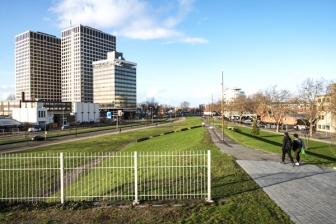 Perspective of the plot: view towards Marconiplein from Dakpark
 The park: in-between Merwe-Vierhavens (left) & Bospolder (right)
 Perspective of the plot from Marconiplein
Questions on the site
In the complete site folder there is an empty subfolder with the name "PS-e_maps-topography". Since the site is L/S and the park has a steep slope, I wonder if some more information about topography or the height of the surrounding buildings is going to be given soon or if we should find it by ourselves.
There is an online 3D model of Rotterdam: https://3drotterdam.nl. In this model you can create your own section and export the file.
where can we find the heights and levels of the streets and surrounding buildings? I could not find them on the CAD files Thanks
There is an online 3D model of Rotterdam: https://3drotterdam.nl. In this model you can create your own section and export the file.
Is there any information about the building size, a concrete program of the intervention or an estimate of how many people will live/work here ? Is it a part of the assignment to find the scale of the intervention?
The percentage of the plot that can be built is not defined. Only the maximum height of 50 meters for the whole plot is defined. It cannot be as high as the Marconi Towers. However, it’s a competition. You are allowed to think outside the box and be critical. A pricelist with the calculation method of (social) house prizes per m2 will be added to the Complete Site Folder. The assignment asks for a mix in housing, aimed at offering homes for a.o. people already living nearby in BoTu. You can challenge the plan-sizes and amounts of dwellings and types. Be sure to look for ways to think through the live-work typology of the building. For feasibility reasons on social housing, the housing corporations need to build at least 50 houses on each site to be able to develop, so this threshold is relevant also here to take into account. On the site the Municipality wants to build 100-120 houses with the following division: 50% social; 25% lower-middle-class; 25% higher-middle-class or high; 0% very-high or ‘happy few’ category. However, as Europan wants to innovate, please be critical.
I would like to ask if there is any report of the site visit or it will be added soon? If yes, where can I find it? In the complete site folder there isn't any new file. Moreover, do you have any section of the site?
The report of the site visit can be found here:
https://www.europan-europe.eu/media/default/0001/18/e15_nl_kopdakpark_site_visit_report_pdf.pdf
Unfortunately we do not have a section of the site. You can however find the height of the ground level in general on this website:
Good morning! After reading the report of the site visit We would like to ask 2 questions. Where is the section of the dike? We cannot find it in the complete site folder. Should we keep the existing slope running from Marconiplein till the entrance of the car park? Is it park of the dike structure? Thank you so much!
The Dakpark doubles as one of the most important dikes in Rotterdam. So please consider its infrastructural value for water safety in thinking through possible manipulations of the dike and park slope. A height map of the site has been supplied by the municipality and will be uploaded as JPEG into the site folder at the beginning of next week.
This site is connected to the following theme
CREATING PROXIMITIES CREATING PROXIMITIES Third spaces in-between
Third spaces in-between
In the physical space of the city, but also at temporal and actors' scales, it is about establishing proximities between living and working both within residential areas and between residential areas and monofunctional production zones. It is also about rethinking the transition between high-speed metropolitan mobility and the low speed of neighbourhoods.
A third space is a new space inserted between housing and production areas that can catalyse the transformation of current production cycles by creating synergies with urban territories and everyday life. It can be located in residual spaces within neighbourhoods, between existing monofunctional zones or emerge from recycled urban fabric.
Questions on the site
You have to be connected –and therefore registered– to be able to ask a question.
Fr. 16 May 2025
Deadline for submitting questions
Fr. 30 May 2025
Deadline for answers
Before submitting a question, make sure it does not already appear in the FAQ.
Please ask questions on sites in the Sites section.
Please ask questions on rules in the Rules section.
If your question does not receive any answer in 10 days, check the FAQ to make sure the answer does not appear under another label or email the secretariat concerned by the question (national secretariat for the sites, European secretariat for the rules).