Rotterdam Visserijplein (NL)
The Synthetic Site Folder and Site Brief are available for free.
Please register and login to access the Complete Site Folder.
- Synthetic site folder EN
- Site Brief EN
- Site on Google Maps
- Back to map
Data
Project scale L/S - urban + architecture/ architecture + context
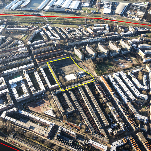
Location Rotterdam, Bospolder Tussendijken, Visserijplein
Population 650,000 inhabitants
Strategic site 61.5 ha – Site of project 2.2 ha
Site proposed by Municipality of Rotterdam
Actors involved Municipality of Rotterdam, Delfshaven Coöperatie, St. Park 1943, Havensteder, Bibliotheek Rotterdam, Pier 80
Owner of the site Public and private ownership
Commission after competition Design (or research-by- design) assignment on implementation on the project site (or a site with similar characteristics) commissioned by the municipality of Rotterdam and/or private partners
Team representative Architect - urbanist
More Information
How can the site contribute to a productive city?
The accessibility of learning environments in the broad sense is crucial for the empowerment of vulnerable citizens and the future career opportunities of children. Improving the resilience of residents in vulnerable urban neighbourhoods, like Bospolder Tussendijken (BoTu), requires a local network of places with a mix of functions to meet, learn, make, play and work. Transforming natural meeting places, like the Visserijplein in the heart of BoTu, into such a multifunctional ‘hub’ ensures that these new interaction milieus are deeply rooted in the daily life of residents.
City strategy
The City of Rotterdam seeks opportunities in the combination of accommodating its growth and creating a more inclusive city. To lift the socioeconomic status of vulnerable neighbourhoods, like BoTu, it focuses on improving the perspective of vulnerable residents in the area. To this end, it aims to remove barriers so that everyone can participate more easily in social and societal processes, with equal opportunities in education, work, culture and sports. Upgrading and diversifying the housing stock, and improving educational infrastructures are important basic strategies. In addition, strategic urban interventions – new developments on a relatively small scale and a more attractive public space – are used to embed mixed programmes and facilities in the heart of these neighbourhoods, empowering residents of all ages on multiple levels and building a just and equitable city.
Site definition
The project site is located in the heart of BoTu. The site is bordered on three sides by archetypal serially produced housing blocks (partly after the Second World War) and on one side by Park 1943. Twice a week the square is the setting of a busy market. On the other days of the week, it is a large underused open space. Pier 80, a multifunctional community centre, is located on one end of the square. It includes a library, sport facilities, and (co)work and meeting spaces. The current programme of Pier 80 already attracts many residents, but should be more progressive. The challenge is to design a multifunctional building block in the heart of a multicultural, vulnerable neighbourhood, incorporating (part of) the local market and providing space to new forms of living, meeting, learning, making, playing and working – by analogy of new concepts like the Library of the Future – to give the area a socioeconomic boost.
How is production inserted in the urban diversity programme?
Rotterdam is growing. The city aims to build 50,000 new homes in the next decade and to vigorously enhance the quality and energy performance of the existing built environment. Rotterdam is looking for ‘good growth’: building a compact, circular, productive, healthy and inclusive city with equal opportunities and high quality of living for everyone. It aims to be a vibrant and welcoming place for people of all walks of life, ages and beliefs, enabling them to prosper. Citizens of Rotterdam should be able to live productive lives by working, learning, caring or in any other way contributing to the development of the city and its narratives. Therefore, it is important to remove barriers, to increase connectivity.
Europan 15 focuses on sites that might catalyse opportunities on multiple levels, places of meaning that might enhance the city’s social resiliency. These are some of the abstract notions rooted in the new Rotterdam vision and regulatory framework on spatial and socioeconomic developments, called the Omgevingsvisie. This framework is currently being drafted by the municipality. It should accelerate innovative spatial solutions and sustainable socioeconomic developments. It is supported by an extensive participatory process and an action research program. The Europan15 sites have been selected to implement this process, through research-by-design and its aim of implementing exemplary projects.
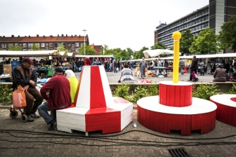
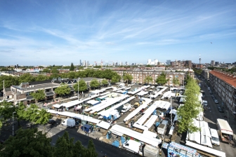 Visserijplein weekly market
 Visserijplein on market days
 Visserijplein and housing units
 Building typologies of the project site: residential units & small shops
Questions on the site
I have download all the information after the registration from the complete site folder. Its all plan at different scale, is there any way to get some section of the area or a 3d of the context in order to have also the height of the surrounding buildings? Thankyou so much
There is an online 3D model of Rotterdam: https://3drotterdam.nl. In this model you can create your own section and export the file.
Is it possible to have the plan with the room of the Pier 80?
We are trying to get access to the file and will update the Complete Site Folder soon.
Can we have more information or document about the new housing developement plans in and near the area. Can we also have the strategic plans with the documents for the education and the Nicolaasschool improved plan
We've added the "Gebiedsatlas" to the Complete Site Folder (see subfolder: Brief). Unfortunately, the document is available in Dutch only. In short:
- Tussendijken has a dynamic urban character, Bospolder a quiet urban character; this asks for various target groups. (pp. 8-9)
- The policy for both neighbourhoods is to reduce the housing stock for lower incomes. The aim is to increase the housing stock for the top end of the middle class, and a small part for the lower end of the middle class. (pp. 11-13)
- See also the map with the intented development per district. (p. 17)
The detailed plans for the Nicolaas school are not public. You can download the general plans here ("Integraal Huisvestingsplan"): https://www.rotterdam.nl/loket/documentenkcc/ondIntHuisvestingsplan.pdf
• SITE LIMITATIONS: 1. Are there limitation in height/number or storeys? 2. Is there a distance to be maintained from the surrounding buildings? • PROGRAM: 1. What is the maximum BVO? 2. Do you already have an idea about percentages per function?
There are no concrete building plans for the location Visserijplein yet. The Europan competition is open to new ideas and concepts for this location. Maximum BVO or percentages are therefore not provided and open for interpretation by the Europan participants. A spatial plan at this location however would benefit by taking into account the human scale. Also the plan should be an addition to the current urban fabric and relate to the historic urban fabric, and should be fitting to and adding to the surrounding spatial qualities. The location is outside the borders of the Rotterdam highrise vision.
Is it possible to demolish the existing building Pier 80 in the new planing?
Yes that is possible. Concept visions for the future design of this area also do not always include this building. These visions show complete redesign with new buildings at this location and demolition of Pier80.
When you will be able to upload the plans for the P80? They still didn't appear in the complete site folder
The files have been uploaded in the Complete Site Folder Visserijplein. The.pdf files are called: 'Pier80 - Ground Floor Plan' and 'Pier80 - First Floor Plan'.
In the introduction it is written: In short, the challenge is to design “a” multifunctional building block. Does that mean we can have only one building? Or could it be several buildings?
You are free to choose either to envision one building or several buildings. Also you are free to decide if you want to transform the existing buildings or demolish them.
I would like to ask what are the size of 3 images for communication and 4-pages document?
More information on the product requirements can be found on https://www.europan-europe.eu/en/session/europan-15/rules/
Here you find this information:
Documents for the project communication
- One short text of maximum 800 signs (spaces included, to be typed in during submission) developing the project ideas;
- 3 separate JPG images that symbolize the project (max. 1Mb per image).
Text
- 3 to 4 (max) pages with limited visuels;
- PDF format;
- Vertical A4 (L 210mm x H 297mm).
Can we redesign the road around the site?
You are free to rethink and critically reflect on the site and its public space. So within the scope of the project limits you might rethink its design. However do think contextually, the site is part of a larger urban area and should remain well connected, also given its central position and program.
On p.26 of the Brief you mention that ”gymnasium in the area no longer meet the current standards”: could you be more specific about these standards?
The gymnasium doesn't meet the current standards of sustainable building and climate regulation. Also, the dimensions do not fit the current demand of programming.
Is the new Sint Nicolaas school going to have its own new sport facilities according to the new standards or are they going to use the new ones in Visserijplein ?
The aim is to use the available space in an innovative way, thus searching for synergy of spatial usage that might enhance the use of public space, invite smart double usage and enhance community building, safety, health and also climate adaptation.
Looking at the historical maps, the street profile of the Grote Visserijstraat between Visserijplein and Park 1943 is not original. Is it possible to adjust the street profile and thus to cut either in the Visserijplein or in the Park 1943, making the indicated plot larger or smaller?
You are free to rethink and critically reflect on the site and its public space. So within the scope of the project limits you might rethink its design. However do think contextually, the site is part of a larger urban area and should remain well connected, also given its central position and program.
Do we have to take car parking into consideration for the housing that is yet to be realized at the Visserijplein? If so, is there a formula?
Contemporary or future visions on mobility and parking are welcome. A parking formula of 0.1 – 1.2 cars and 2-5 bicycles is now considered depending the size of the homes for BoTu as a urban neighbourhood, however parking space might also be solved at 300 meters outside the development and at 100 meters for bicycles. Please refer to https://zoek.officielebekendmakingen.nl/gmb-2018-60992.html for more precise information (the document is in Dutch).
About urban regulations, is there any buildable limit in the study plot? As there is not height limit in the plot, is there any height limit within the city of Rotterdam?
Yes there is, the height limit at this site is 70 meters for the site is not within the highrise borders. However, more importantly any intervention should be contextually fitting. So if you choose not to respect the given height limit, then do elaborate on that decision. Europan 15 should open up new perspectives, so feel free to take a critical and creative stance, as long as it is contextually motivated.
About the street market, how often does the street market take place? Once per week? everyday?
The market is held twice a week, currently every Thursday and Saturday. It holds about 176 stalls that embody the multicultural character of the city. Next to produce from all corners of the world, also classical Dutch herring, cheese, ‘drop’ and tulips are sold.
About BoTu energy transition planning, is there any urban plan with the facilities involved located?
The program is experimental but with a strong direction and purpose. Several institutions are working together with local communities to move forward on the energy transition at several levels. Like the International Architecture Biennale Rotterdam (IABR), the Delfshaven Cooperation and may others. A good feel for what is happening you can find – as said in the Q&A earlier – in the GoBoTu website: https://www.gobotu.nl/ and that of the IABR https://iabr.nl/en/projectatelier/energiewijk-bospolder-tussendijken.
About the programme and activities to be included in the multifunctional block building, you explain as mandatory requirement: the market, Pier 80 activities and 2 kind of housing typology? However, do you have any meassurement idea how many square meters are needed of each of them?
Europan 15 is aimed at finding a new design proposal for this area. The square meters for the design are not specified, it is part of the Europan design challenge to find fitting proportions for the required program. Only the requirements for the sport-concept are given. Feel free to come up with creative solutions for an integrated design.
About the strategic plan to improve the educational infrastructure in BoTu, is it possible to clarify the strategy within the schools?
All over Rotterdam the aim is to enhance the performance and quality of schools. The focus is to position schools as key in the improvement of opportunities for the people of the city and as the embodiment of the resilience of the city. Therefore Rotterdam is investing in healthy and sustainable school buildings and in the design of inviting and resilient school playgrounds. Safety of children, climate adaptation, healthy urban living, inclusion, productivity, job opportunities and meeting between communities and generations is key, also in BoTu. But Rotterdam also has to be smart with its investments and its use of space, especially in neighbourhoods where both are scarce. So look for innovative spatial solutions and the right programmatic mix.
Are we allowed to built floors bellow terrain level, and is there a limit for this?
You are free to rethink and critically reflect on the site and its public space. So within the scope of the project limits you might rethink its design. However do think contextually, the sub terrain is not off limits but do know that in the Netherlands – given its groundwater level – this might pose all kinds of challenges. So you should be solid in your considerations and motivation.
Do we need to plan for parking spaces within the plot?
Contemporary or future visions on mobility and parking are welcome. A parking formula of 0.1 – 1.2 cars and 2-5 bicycles is now considered depending the size of the homes for BoTu as a urban neighbourhood, however parking space might also be solved at 300 meters outside the development and at 100 meters for bicycles. Please refer to https://zoek.officielebekendmakingen.nl/gmb-2018-60992.html for more precise information (the document is in Dutch).
Can we decide to leave the existing Pier80 building, without thansforming it in any way?
You are free to rethink and critically reflect on the site. So within the scope of the project limits you might rethink its design. However do think contextually. The adaptive reuse of existing buildings could pose a strong proposition in itself. So if you feel re-thinking the site should have the existing structure remain, you are welcome to propose so.
Is it possible, within the project site, to dig a basement and place any underground space?
You are free to rethink and critically reflect on the site and its public space. So within the scope of the project limits you might rethink its design. However do think contextually, the sub terrain is not off limits but do know that in the Netherlands – given its groundwater level – this might pose all kinds of challenges. So you should be solid in your considerations and motivation.
Is it possible to change the length, position and direction of the roads within the project area?
You are free to rethink and critically reflect on the site and its public space. So within the scope of the project limits you might rethink its design. However do think contextually, the site is part of a larger urban area and should remain well connected, also given its central position and program.
Is it possible to intervene on the ground floors of the buildings within the project area?
Europan 15 is aimed at opening up new perspectives. So yes, please propose any idea but make sure it is rooted contextually, both from a spatial perspective as well as a programmatic one.
Is there any height limit for the new buildings within the project area?
Yes there is, the height limit at this site is 70 meters. However, more importantly any intervention should be contextually fitting. So if you choose not to respect the given height limit, then do elaborate on that decision. Europan 15 should open up new perspectives, so feel free to take a critical and creative stance, as long as it is contextually motivated.
Does the market take place all year long or is seasonal? How often does it take place?
The market is held twice a week, currently every Thursday and Saturday. It holds about 176 stalls that embody the multicultural character of the city.
Next to produce from all corners of the world, also classical Dutch herring, cheese, ‘drop’ and tulips are sold.
This site is connected to the following theme
IMPLANTING IMPLANTING Productive milieus
Productive milieus
The challenge for cities to be both productive and sustainable is to interlink resources, mobilities and conditions of fairness. There are two aspects to implanting new dynamics or reactivating resources such as urban farming and educational, research or creative forces: productive milieus and productive uses.
This is the level where a natural, cultural, social or economic environment is implanted or revitalised symbiotically, by contrast with the architecture of objects or the urbanism of technocracy. So what is needed is to activate human and nonhuman resources and an ecosystem of partners, while at the same time paying attention to integrative values between nature and culture.
Questions on the site
You have to be connected –and therefore registered– to be able to ask a question.
Fr. 16 May 2025
Deadline for submitting questions
Fr. 30 May 2025
Deadline for answers
Before submitting a question, make sure it does not already appear in the FAQ.
Please ask questions on sites in the Sites section.
Please ask questions on rules in the Rules section.
If your question does not receive any answer in 10 days, check the FAQ to make sure the answer does not appear under another label or email the secretariat concerned by the question (national secretariat for the sites, European secretariat for the rules).