Sant Climent de Llobregat (ES)
The Synthetic Site Folder and Site Brief are available for free.
Please register and login to access the Complete Site Folder.
- Synthetic site folder EN | ES
- Site Brief EN | ES
- Site on Google Maps
- Back to map
Data
Project scale L - urban + architecture
Location Can Molins. Sant Climent de Llobregat, Barcelona
Population 4,038 inhabitants
Strategic site 36.86 ha - Project site 9.1 ha
Site proposed by Incasòl
Actors involved Incasòl and Sant Climent City Council
Owner of the site 70% Incasòl, 10% Municipal Council, 20% private owners
Commission after competition Project for part of the elements resulting from the final plan. Public space, housing, etc.
Team representative Architect - urbanist - landscaper
More Information
How can the site contribute to a productive city?
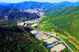
Sant Climent’s industrial zone is located in the study area, alongside the project site. Although it is still active, the crisis as a whole, but particularly the crisis in the textile industry, has caused a degradation of its buildings and associated facilities.
The current planning guidelines enable new economic activities in this area on the basis of pre-existing sports uses in a section of the proposed site. The obsolescence of the existing sports facilities, now unused, and the town’s privileged location in the Baix Llobregat district —near the sea and close to high-density residential areas— make it quite feasible to propose new sports and leisure-related activities which may act as a driving force for the local productive economy.
Another aim of the proposed land development is to redirect traffic away from the industrial area, currently the entrance point to the city. This would solve some of the traffic problems currently generated in the economic zone, improve the parking facilities, accessibility and image of the sector, and have side benefits for good governance.
City strategy
Sant Climent de Llobregat is a unique outer metropolitan municipality with a large agricultural economy, notable landscape values and a good quality of life. However, its main entrance point from Viladecans runs along a narrow corridor parallel to the Riera de Sant Climent stream, flanked by old industrial buildings that cause traffic congestion and seriously compromise the city's image.
The city has a long-standing aspiration for a new entrance point with a ring road and two bridges to surmount the difficulties posed by this riverside road alignment. The project is seen as an opportunity to provide solutions for a range of challenges: new housing, new economic activity, a new urban and forest landscape, and a new image for the entrance to the city.
Site definition
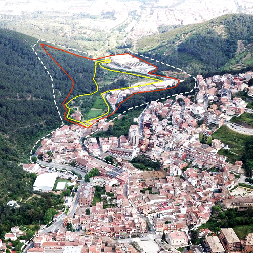
The site is in the Sant Climent de Llobregat municipality, part of the Barcelona Metropolitan Area, at the entrance to the city from Viladecans on road BV2003. This is the natural exit point from the San Climent valley down towards the Llobregat River delta. The town’s industries are located here, spreading across the entire right bank of the Riera de Sant Climent stream.
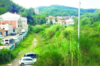
On the left bank is the old soccer field, now in disuse, the heritage-listed Can Molins farmhouse and cherry orchards, vestiges of an agricultural sector that once covered about 9 Ha- all the flat land and terraces in the municipality. Between the new fire station at the start of the industrial zone and the turn-off to the city centre, the road meanders alongside the Riera, with the old municipal football field and the Can Molins farmhouse grounds to the left. This situation is an opportunity to study a new entrance to the city on the left side of the Riera and a new development sector, making the most of the public ownership of most of this land: municipal in the case of the football field and INCASÒL in the case of the Can Molins estate. The boundary with the forested sector can be considered to be flexible once the planning proposal has been studied. In order to work on this proposal, the study area includes the industrial sector, the project site, and the tree-covered part of the estate, in a broad sense.
How is production inserted in the urban diversity programme?
The construction of a new road access to the town will help to resolve several issues at the same time and poses two crucial challenges:
1) How to resolve the landscape and environmental issues, a relevant aspect due to the physical and topographical features of the sector,
2) How to ensure the viability of the proposal, especially in financial terms, taking into account the cost of the infrastructure associated with a dual carriageway road.
Assuming that both challenges will be addressed in the submitted proposals, this sector is expected to resolve three issues at the same time:
1) A new sports (or leisure) activity that can act as a driving force for the local economy, promoted by the private sector,
2) Inclusive housing development, with private and public dwellings at the service of the general and local housing policies,
3) Improvement of the urban and forested landscape around the main entrance to the town.
An additional challenge is posed by the heritage-listed Can Molins farmhouse, whose future uses should be addressed in the submitted proposals, and the possibility of a Modification to the Master Plan to permit proposals that modify different zoning areas.
 Aerial view of the project site
 Project site - unused spaces
 Confrontation of natural and urban elements
 Streetscape and buildings typologies
Questions on the site
Is Can Molins municipaly property or is it private? Is it possible to have a site in dwg in a more closest scale? If I am not mistaken, the ones we have is at 1/5000 and it is the same in both folders 1/2000 and 1/500. Thanks.
OWNERS OF THE SITE: 74% Incasòl, 10% Municipal Council +16% diferent private owners
The closest site plan, is the topography one. It's included in folder 3-Project_Site/PS-e_masp-topography/ES-SantCliment-PS-M2.dxf
We have added a new plan including project area and study area in the topography map. (ES-SantCliment-PS-M2a.dxf)
Would it be possible to obtain more information about Can Molins (distribution or some pictures of the interior)?
Can Molins plans and pictures have been added to the complete site file. See "0-New_Docs_after_Launch"
Is it possible to have de plant of Can Molins?
Can Molins plans and pictures have been added to the complete site file. See "0-New_Docs_after_Launch"
Where can I take de plan regulation of de town? In catalan is POUM. Thanks
Sant Climent de Llobregat doesn’t have an own POUM because it’s included in PGM (Barcelona Metropolitan General Plan)
You can link this address. It is the Consolidated Urban Planning from all Barcelona Metropolitan Area.
https://geoportalplanejament.amb.cat/AppGeoportalPlanejament2/index.html
Is it necessary to follow the metropolitan plan?
Not at all. You don't need to follow the metropolitan plan.
Please, feel free to consider bold but consistent proposals, thinking about the surroundings and preexistences.
Would it be possible to obtain a CAD map of the northern area of Sant Climent, as the two provided don't show this part of the town?
As we don't really know the exact map you need, you can download any map you need from this link: https://geoportalcartografia.amb.cat/AppGeoportalCartografia2/?locale=ca&Categoria=Cartografia&Producte=1. You have to be a user, but everybody can do it. The maps we have already provided are: 420-23-40 420-24-40 and 448-23-01 448-24-01
When you ask "How to ensure the viability of the proposal, especially in financial terms, taking into account the cost of the infrastructure associated with a dual carriageway road"; Does it mean that we have to prove it with numbers and / or budgets?
The project should ensure the economic viability. It means you should take into account the cost of the urbanization, and see how much profit the sector needs. Of course we don't want too much height in the buildings, which has to be in relation with the urban and rural environment, but the cost of the urbanization has to be coherent with it.
If it is non-viable, it should be exposed how much the economic loss is, to see how can it be covered.
Would be posible to know the forest plots' property (public or private) near the project area?
ES-SantCliment-SS-M2 file has been added to the complete site folder. In the map, yellow area belongs to Incasòl, orange area belongs to municipality. Other properties are private.
In terms of flooding what rule we should follow? ACA has any rule about that?
Europan is an ideas competition and, therefore, it is not necessary to follow a specific regulation. You only have to take into account the fact of the flooding of the area and the map of flooding that has been published in "Documents after launching". It should be noted that residential uses are excluded from the flood zone though industrial ones could be compatible
EUROPAN es un concurso de ideas y, por tanto, no hay que seguir una normativa específica. Basta con tener en cuenta el hecho de la inundabilidad de la zona y el plano que, a este respecto, se ha publicado en "Documents after launching". Cabe señalar que los usos residenciales quedan excluidos de la zona inundable y los Industriales podrían ser compatibles.
This site is connected to the following theme
CREATING PROXIMITIES CREATING PROXIMITIES Third spaces in-between
Third spaces in-between
In the physical space of the city, but also at temporal and actors' scales, it is about establishing proximities between living and working both within residential areas and between residential areas and monofunctional production zones. It is also about rethinking the transition between high-speed metropolitan mobility and the low speed of neighbourhoods.
A third space is a new space inserted between housing and production areas that can catalyse the transformation of current production cycles by creating synergies with urban territories and everyday life. It can be located in residual spaces within neighbourhoods, between existing monofunctional zones or emerge from recycled urban fabric.
Specific documents
Questions on the site
You have to be connected –and therefore registered– to be able to ask a question.
Fr. 16 May 2025
Deadline for submitting questions
Fr. 30 May 2025
Deadline for answers
Before submitting a question, make sure it does not already appear in the FAQ.
Please ask questions on sites in the Sites section.
Please ask questions on rules in the Rules section.
If your question does not receive any answer in 10 days, check the FAQ to make sure the answer does not appear under another label or email the secretariat concerned by the question (national secretariat for the sites, European secretariat for the rules).