Bassens / Bordeaux Métropole (FR)
The Synthetic Site Folder and Site Brief are available for free.
Please register and login to access the Complete Site Folder.
- Synthetic site folder EN | FR
- Site Brief EN | FR
- Site on Google Maps
- Back to map
Data
Bassens / Bordeaux Métropole (FR)
Scale S+XL
Team representative architect, urbanist, landscaper
Location Bassens (33)
Population Bassens 7,500 inhabitants / Bordeaux Métropole 801,041 inhabitants
Strategic site 2300 ha - Project site 340 ha (2 sites)
Site proposed by Ville de Bassens, Bordeaux Métropole, Grand Port Maritime de Bordeaux
Actors involved Ville de Bassens, Bordeaux Métropole, Grand Port Maritime de Bordeaux, GPV Rive Droite
Owner(s) of the site Ville de Bassens, Bordeaux Métropole, Grand Port Maritime de Bordeaux et privé
Commission after competition urban, architectural and landscape studies
More Information
Urban City Strategy
The project site area, between the limestone plateau and the alluvial plain raises questions about the role of the river in creating a new territorial intelligence and new links between environments.
The challenges of programmation of use and mobility must be defined, in terms of revitalization and interface, in order to enhance and connect ecosystems evolving in parallel on the site.
A work on the theme of the living city, as a composite city, should therefore make it possible to initiate the setting in spaces and temporalities of new economic, ecological and energy challenges, in a human and sensitive strategic approach.
Site Definition
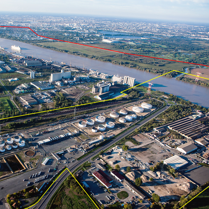
Bassens is the last dense city north of the Bordeaux metropolis. Extending over more than 1000 hectares, it marks the end of the slope of the right bank of the Garonne.
The topography of the area, as well as the presence of the Bordeaux–Paris high-speed trainline (LGV: ligne grande vitesse), constitute physical boundaries that separate the town into two parts:
- A lower part, the industrial–dockland area, which stretches along the river for more than 4km.
- An upper part, a populated plateau, which develops in the middle of green spaces and natural areas.
Crossing this boundary from the populated plateau to reach the river banks is one of the main challenges for the city of Bassens.
New uses will be developed in connection with the river, in a concern of valorization and preservation.
The hybridisation of the territory, considered on the one hand as an entrance to the city and on the other hand as its limit, should more generally allow the creation of a new coherence including the industrial-port ecosystem.
How Must Metabolism and Inclusivity Be Developed and Connected?
How can the city be made more accessible? How can it be made more animated? How can it be shared?
The challenges of programmation of use, with regards new ways of understanding, linking and adding to existing urban logistics structures must be considered, in terms of facilities, gathering together and exchange.
The industrial–dockland ecosystem contrasts with adjacent ecosystems, such as that of the residential town, and must be rethought in terms of interaction and amenity.
Spatial multifunctionality must redress years of urban zoning that neglected social, geographic and landscaping contexts, and more generally the possible connections between different environments.
Consideration of daily transport, both for individuals and for business, must also be put at the centre of the reflection.
Relevant solutions regarding the performance of the region and the involvement of new users are requested, taking into consideration any possible consequences on the human and the natural environments impacted which are already present on the site.
In an evolving economic ecosystem, looking for new connections, how can a new diversity also be created, bringing together existing conditions and increasing the capacity of existing urban infrastructures?
How can the area juggle economic and urban development, climatic risks and challenges, transform itself, renew itself and reply to the various issues of biodiversity, resilience and adaptation?
What might be the motors for a participative diversity and decisive redynamisation for our study site, and how can they be made to work together, taking into account the logistic and economic constraints of the industrial–dockland zone?


Questions on the site
Two documents FR-BESSENS-PS1-M1 et PS2 show plots indicated as having "immediate operationality". Can you explain more? Does this mean that the plots can mutate or just that the site can evolve in the short term, but maintain its primary functions?
The plots indicated as having immediate operationality are indeed mutable.
The question of evolution and connection of uses is essential.
The other plots can also enter into a mutation process with longer term phasing.
Can we imagine a public access on the sequence of the riverside wharf on site 2 or should we keep in mind that the site belongs to the port of Bordeaux and will therefore remain private?
The sequence of the riverside wharf proposed for the study will in fact remain the property of the port. The question of access, in relation to the uses developped, remains at the initiative of the candidates. We remind you that the public is not allowed to circulate on the riverside wharf and that all the activities that will be implemented there will have to be linked to port and/or metropolitain logistics. Other uses may be developed outside the port.
Is there any GIS data available for the site? (GIS data like Building footprints, Land Use, Rail and road network (including speed limits), Soil data, Contours (Topology) / Slope / Water Images of the development area, Area boundaries in GIS)
All the documents authorized for publication are available for download in the complete site folder from the Europan Europe website, after registration.
You can also visit the Bordeaux Métropole open data site and download additional data and documents at the following adress: https://opendata.bordeaux-metropole.fr/pages/accueil/
Can you provide (or is there any) 3D file for the whole city (shown in page 20 of Site Brief)? If not, we will develop from the DWG and OpenStreet Map.
All the documents authorized for publication are available for download in the complete site folder from the Europan Europe website, after registration.
You can also visit the Bordeaux Métropole open data site and download additional data and documents at the following adress: https://opendata.bordeaux-metropole.fr/pages/accueil/
Can you tell us if the railroad tracks inside the Port are in use or if they are fallow? If they are still in use, is it the SNCF that manages the network?
The railroad tracks within the Port are used or usable. They are managed by the Port.
This site is connected to the following theme
Revitalization On these sites, the impetus for the transformation comes from the territory and from the use of all the resources (natural, ecological, infrastructural) to regenerate them.
Making Territories Performative
Here, the territory needs to be reconnected to its social context to add new creative and cultural qualities.
Specific documents
Questions on the site
You have to be connected –and therefore registered– to be able to ask a question.
Fr. 16 May 2025
Deadline for submitting questions
Fr. 30 May 2025
Deadline for answers
Before submitting a question, make sure it does not already appear in the FAQ.
Please ask questions on sites in the Sites section.
Please ask questions on rules in the Rules section.
If your question does not receive any answer in 10 days, check the FAQ to make sure the answer does not appear under another label or email the secretariat concerned by the question (national secretariat for the sites, European secretariat for the rules).