Limoges (FR)
The Synthetic Site Folder and Site Brief are available for free.
Please register and login to access the Complete Site Folder.
- Synthetic site folder EN | FR
- Site Brief EN | FR
- Site on Google Maps
- Back to map
Data

Limoges (FR)
Scale L & S urban and architectural
Team representative urbanist, landscape architect & architect
Location Limoges, France
Population 133,000 inhabitants
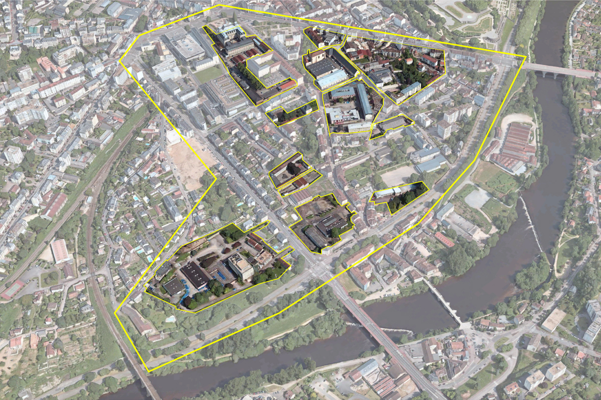
Strategic site 97 ha - Project site 48 ha
Site proposed by Ville de Limoges
Actors involved Ville de Limoges
Owner(s) of the site Ville de Limoges, privates plots
Commission after competition Architectural and urban studies, project management contract
More Information
Urban City Strategy
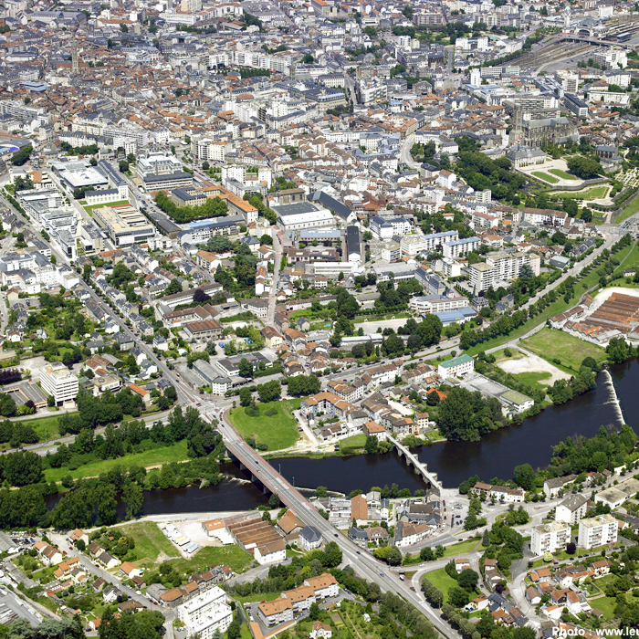
The site, a rich palimpsest since its Roman foundation, has experienced great vitality through the industrial activities that coexisted there and of which many traces remain, then entered a phase of quiescence as if there had been a form of exhaustion here of the place.
The site is now in a strategic location, between the ongoing redevelopment of the edges of the river La Vienne, and the actions carried out in the city center offered to the inhabitants’ leisure. It is now exposed, in the absence of a project formulating its new identity, to a sprawl of operations, at the discretion of private logics, escaping a collective ambition and taking advantage of the new attractiveness of these places.
By its location in the territory the site carries the 3 challenges of the 3 cities which coexist in Limoges: the dense city-center which today becomes that of the pedestrian, the road city which runs along the Vienne river, the city-countryside constituted by the landscape of the two valleys connected to the natural and agricultural spaces which occupy the large municipal territory. On the scale of the city’s transformations, the site invites us to extend the collection of actions underway in the “Action Cœur de Ville” program, made up of a constellation of projects.
By taking a look at this site through this session, the city of Limoges, which is based here on the theme «living city», therefore suggests that a new cycle of life must be put into action here.
Site Definition
The suburban fabric on the slope with its confidential road network, is a built ecosystem to be revealed. It can create a living environment through inventive logic of transformation, including present and future inhabitants, and new uses.
The steep slope of the site with the presence of retaining walls gives it a special character, with belvedere over the wide landscape and large private or public platforms, or fallow. The plant holdings are to be revealed: they represent 3 ha of gardens or planted spaces which thus interfere in this urban fabric.
The perimeter accommodates some large facilities but despite their presence the district remains mainly residential, unattractive. The planned edges of Vienne are voluntarily excluded from the scope of the project, their development and programming being in progress. On the other hand, it is on the links with this project and especially on the national 520 that we are asked to look at it. It is surely here that the connection with the Vienne for the district and the city center is played out in the first place.
How Must Metabolism and Inclusivity Be Developed and Connected?
The new life cycle expected here, by proposing an adapted project process, must take care of the social and built structure by revealing the possible co-relations with the actions in progress, while affirming a singular approach. The neighborhood is among those with the lowest income level in the city. This process must therefore take into account the existing living environment and define in what form of metabolism, each stakeholder of the site will enter into a relationship to participate in this reconquest.
By engaging in a process of conversion integrating its valuation over time, the site can create new complicity with the Vienne valley project as an element of entry and irrigation of nature, from the banks to the city centrer, allowing the inhabitants of Limoges to rediscover the leisure of a city. To do this, the renewal of the neighborhood must participate in the making of an eco-city and its development must be based on frugal urban planning, mobilizing a resource economy reusing and recycling existing spaces to allow this transition.


Questions on the site
Concerning the GRDF and ENEDIS wastelands, are you aware of any pollution resulting from the exploitation of the sites?
In Limoges, several sites have been the subject of studies and pollution control treatments as part of the development of the SIS (Sectors of Information on Soil)*. Regarding the Europan site, the two Enedis and Engie sites were cleaned up between 1999 and 2003. Although the treatment of the pollution detected was carried out during this period, it is important to take into account the uncertainties that remain as a result of the activities that have continued on the two respective sites. Additional studies - relating to land movements and or future works that would imply a change of use of the site - will have to be carried out.
All of the elements of these studies and soil treatments are clearly outlined in the following two links which also contain links to more specific documents:
Former Gas Plant Limoges " 19bis Révolution " Engie ex GDF + Enedis ex EDF 19 bis avenue de la Révolution: https://fiches-risques.brgm.fr/georisques/infosols/instruction/SSP000422901
Pollution study:
https://fiches-risques.brgm.fr/georisques/infosols/document/doc-depollution-87.0011--1.pdf
https://fiches-risques.brgm.fr/georisques/infosols/document/doc-depollution-87.0011--2.pdf
Former Gas Plant Limoges " 4bis Révolution " Engie ex GDF + Enedis ex EDF 4 bis avenue de la Révolution: https://fiches-risques.brgm.fr/georisques/infosols/instruction/SSP000424301
* SIS
The State draws up, based on the information available to it, Soil Information Sectors (SIS).
The SIS include land where knowledge of soil pollution justifies, particularly in the case of a change of use, the carrying out of soil studies and the implementation of pollution management measures to preserve public safety, health or hygiene and the environment. They are made available to the public after consultation with the town halls and information to the owners.
The publication of SIS is done through this internet portal GeoHazards: https://www.georisques.gouv.fr
Hello, In order to develop a promising project, is it possible to have access to the building maps located on the ENEDIS and GRDF wasteland? Have a nice day
As they are private property, the municipality does not have these elements.
We saw that the GRDF wasteland is hosting migrants. Do we have any additional information, particularly on the number of people and the current occupation methods (squatting, provision of accommodation, tolerance on the part of the city, etc.)? Is the accommodation structured by an association, a collective...?
As indicated in another question, the occupation of a private site is not intended to be permanent and it is therefore appropriate to study the site as a wasteland. The information on the occupation remains too fragmented to answer correctly. Various articles in the press give an idea of how this occupation is taking place. We were not able to visit this site out of respect for the occupants who remain sensitive to any outside intrusion.
What is the city's standing on mobility issues and in particular with regard to the railway hub (Cf. TramTrain Limousin, with the 2 potential stations, Hôtel de Ville and Vienne-Viaduc in the immediate proximity of the Europan site)?
The tram-train project is not identified in the PDU of Limoges Métropole, which provides for a new organization of mobility based on two BHNS (High Quality Service Buses) lines.
The Europan site is directly concerned by the Val de l'Aurence-Panazol B line. The BHNS project includes the complete requalification of the avenues George Dumas and de Lattre de Tassigny with 3 stations located on the perimeter: 1 stop Hôtel de Ville and 2 stops on both sides of the Pont Neuf.
The communicable documents on the BHNS and PDU are available here: https://mobilites.limoges-metropole.fr/
What are the mobility projects supported by the territory, likely to have an impact on the site (road plan, bicycle master plan, public transport...)?
Mobility projects to be taken into account:
- As part of the redevelopment of the banks of the Vienne river: creation of bicycle routes on the two banks of the Vienne river: left bank more for walking (greenway) / right bank for daily commuting (bicycle lanes), with a redevelopment of the roadside platforms.
- In the short term (2022): all the roads in the sector (except for the quays and the avenues Révolution and Dumas) will be placed in a 30 km/h zone.
The Edouard Herriot School is currently located on two different sites. Can you give us the reasons for this configuration?
It is a historic site (1970s) and the school group is divided between the kindergarten, the elementary school and the school restaurant.
How does the municipality view the informal occupation of the GRDF site?
This occupation of a private site is not expected to be permanent and it is therefore appropriate to manage the site as a wasteland.
Are there still activities going on at the Enedis wasteland site? How long has the site been unoccupied?
The Enedis site has been unoccupied since the beginning of 2020, when the headquarters moved to the ESTER Technopole site.
Does the municipality have documents that can inform us about the existing buildings on the wasteland, such as the date of construction, geometry, health diagnosis of the building, etc.?
As they are private properties, the municipality does not have these elements.
This site is connected to the following theme
Care Care is about recognizing the vulnerability of our living milieu. It is about finding new design ways to pay attention to marginalized, hurt, or ignored areas and help to repair them.
Dealing with New Uses
These sites have available building stock at the end of their first or second life cycles. The sites lack strategic uses that could support the transition of the building stock to another life cycle. it is crucial to take care of relations between the uses, the inhabitants, and the building stock itself.
Specific documents
Questions on the site
You have to be connected –and therefore registered– to be able to ask a question.
Fr. 16 May 2025
Deadline for submitting questions
Fr. 30 May 2025
Deadline for answers
Before submitting a question, make sure it does not already appear in the FAQ.
Please ask questions on sites in the Sites section.
Please ask questions on rules in the Rules section.
If your question does not receive any answer in 10 days, check the FAQ to make sure the answer does not appear under another label or email the secretariat concerned by the question (national secretariat for the sites, European secretariat for the rules).