Namur (BE)
The Synthetic Site Folder and Site Brief are available for free.
Please register and login to access the Complete Site Folder.
- Synthetic site folder EN
- Site Brief EN
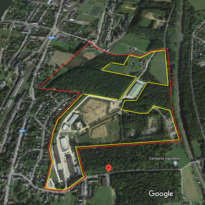
- Site on Google Maps
- Back to map
Data
Namur (BE)
Scale Urban and architectural
Team representative architect, urban designer, landscape architect, structural and technical engineer(s)
Location Namur, Walloon Region Capital
Population 112,000 inhabitants
Strategic site 37 ha - Project site 27 ha
Site proposed by City of Namur
Actors involved Département de l’Aménagement Urbain, Asbl New
Owner(s) of the site Ministry of Defense Belgium
Commission after competition Master Plan
More Information
Urban City Strategy
The landscape of Namur, capital of Walloon Region, is marked by the confluence of two rivers, the Meuse and the Sambre, drawing two valleys at the crossroads of which stands the fortress of Grognon. Facing it, the plain of Jambes develops a varied urbanization, between large urban complexes and single-family dwellings. Two railroads crisscross the landscape, one at the water’s edge, the other on the hillsides.
The Sart Hulet site is located on the slopes of these hills. The view of the Grognon and the rich buildings that have been established there, offers a picturesque lands- cape of great interest. It houses a military infrastructure intended for the training of young soldiers in military engineering. The techniques of construction of buildings, engineering structures, heavy or light infrastructures, etc. were taught there. This teaching was divided between theoretical courses and practical works requiring important infrastructures. Some of the practical works left all kinds of constructions, within the forest nature, generating original biotopes. A Museum of Engineering completed these infrastructures, in order to testify to the public the inventive- ness and the creativity of the military engineering.
Site Definition
Neither rural nor urban, this site is an in-between. Close to the urban developments in the plain of Jambe, and distant by its land- scape characteristics, the site of Sart Hulet offers the opportunity of an original urban development, associating the strength of the landscape to the future buildings morphology, whose economy and ecology will take care to lean on the existing one to suggest intelligent re-employments.
The diversity of the constructions, their size, their constructive qualities (military means), and the amplitude of their structures, offer a wide range of programmatic possibilities, from housing, to productive activities, passing by micro agriculture, breeding, sport, leisure, etc. The city vision is to create beyond Public Housing, a «Planet- Bike» with at least a «velodrome» on the site. It is therefore a whole model of living in a community that must be reinvented from the traces of the past by proposing balances based on the development forces at work in the Walloon capital, while respecting and creating links with the neighboring habitat. But beyond the forms, it is above all a process of appropriation of the site that must be proposed, leaving to time the force of organic arbitrations associating nature with the culture of buildings and the landscape.
How Must Metabolism and Inclusivity Be Developed and Connected?
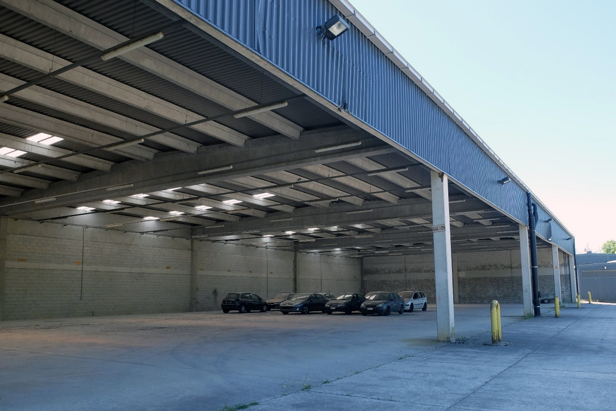
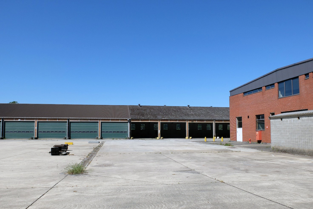
The site contains several constructions and buildings whose sanitary and structural condition is generally good to very good. It is desirable to preserve and rehabilitate as many of them as possible in an eco-responsible approach aiming to limit grey energy losses to a minimum.
The majority of the concrete or brick buildings house ateliers or garages on the ground floor, and classrooms or offices on the first floor (no building exceeds the ground floor + 1).
A hangar of more than 5000m2 completely insulated, concrete mechanical ateliers, a fuel distribution station (potential pollution?), or a Génie Museum integrated in an former agricultural farm, complete this astonishing set.
What to do with this site overlooking the plain of Jambes? How to recover and enhance the existing buildings? How to create living ecological continuities beyond the landscape ruptures? Given the available space and the wooded character of certain parts of the site, what recreational activities could potentially complement productive activities of a community nature? What housing model on this site where the public interest predominates with a share of public housings to be proposed by the candidates?


Questions on the site
Hello, I would like to know when the material will be uploaded to the 3-Project_Site folder
Hello,
Thank you for your request. New documents have been uploaded on the Europan Europe website in the Docs After Launch section.
Unfortunately, we have not received any DWG documents.
Hoping to meet your expectations,
At your disposal for any other useful information.
Sincerely
The Europan.be team
Hello, I would like to know if it is possible to insert qrcodes on the panels that refer to videos or additional data to those presented on the panels delivered.
Hello
Thank you for your question.
No, all data must be visible and readable on the panels.
We will not have the opportunity to show videos or additional information to the jury.
We are at your disposal for any further information.
Sincerely
The Europan.be Team
Hello! Will you provide a dwg of the site? Or at least a topographic map with curves? We have been searching on numerous cartographic sites without luck.
Hello!
Being a military site, the documents are very limited up to now. But we will ask to de city of Namur services if they have global topography documents of this place. We will keep you informed as soon as we get them. Best regards
We have registered on Namur. In the "complete folder" list there are "topography and characteristic elements", but the download process is not available. Is it possible to share these materials? Thank you in advance
In the 0_Docs_After_Launch folder we have uploaded separately all documents available which were incuded in the Zip already on the Europan.Europe Website.
On this site: https://data.namur.be/explore/?sort=modified&q=Pavillon it is possible to download some 3D model of the the buildings in the site. As this site was military protected, the informations are not really detailed. But according to E16 expectations which are not for execution plans, rather visionnary programmatic attitude, the available informations should be sufficiant.
PS: sorry for our late answer!
Hello, On page 6, it is mentioned “The City of Namur will make an official communication on this subject after Easter. “We assume this refers to ‘Planet bike’. Either way: has the city of Namur communicated anything new after Easter?
The city of Namur has not communicated yet. The communication should come in the next days. We will keep all participants informed as soon as possible.
Hello, For the teams who could not go to the visit of 20.05 : is it possible to organize another visit ? or to contact directly the service in charge of the site monitoring ?
A video of the site visit has been posted on the Europan.Europe website in the 0_Docs_After_Launch_Folder.
We are working on a new visit and communication moment, but nothing is sure for now.
We'll let all participant know as soon as we are sure.
As the site is a protected military site, it is not possible to ask directly to the service in charge.
This site is connected to the following theme
Revitalization On these sites, the impetus for the transformation comes from the territory and from the use of all the resources (natural, ecological, infrastructural) to regenerate them.
Reinforcing Biodiversity
Here, the driving force of change is the transformation of the (urban) ecology.
Specific documents
Questions on the site
You have to be connected –and therefore registered– to be able to ask a question.
Fr. 16 May 2025
Deadline for submitting questions
Fr. 30 May 2025
Deadline for answers
Before submitting a question, make sure it does not already appear in the FAQ.
Please ask questions on sites in the Sites section.
Please ask questions on rules in the Rules section.
If your question does not receive any answer in 10 days, check the FAQ to make sure the answer does not appear under another label or email the secretariat concerned by the question (national secretariat for the sites, European secretariat for the rules).