Schwäbisch Gmünd (DE)
The Synthetic Site Folder and Site Brief are available for free.
Please register and login to access the Complete Site Folder.
- Synthetic site folder DE | EN
- Site Brief DE | EN
- Site on Google Maps
- Back to map
Data
Schwäbisch Gmünd (DE)
Scale L, XL architectural and urban design scale
Team representative Architect, landscape planner, traffic planner
Location Town of Schwäbisch Gmünd, Baden-Württemberg, Deutschland
Population c. 61,000 inhabitants
Strategic site c. 138 ha - Project site c. 27 ha
Site proposed by Town of Schwäbisch Gmünd
Actors involved Town of Schwäbisch Gmünd
Owner(s) of the site Town of Schwäbisch Gmünd, private owners, investors
Commission after competition Urban studies in cooperation with the town of Schwäbisch Gmünd
More Information
Urban City Strategy
The town of Schwäbisch Gmünd plays an important role in the Stuttgart metropolitan region. It is thus ambitiously addressing the future of building, living, and working. Two projects from Schwäbisch Gmünd have been included in the IBA‘27 network of the Stuttgart metropolitan region, including the ‘Unbreak my Hardt’ project, which is based on an entry from the Europan 13 competition held in 2015. New ideas and approaches are being sought here for the area on the Stuttgart-facing side of the town, which has undergone significant changes with the relocation of the B29 federal road into a tunnel and the expansion of the Stadtgarten.
Site Definition
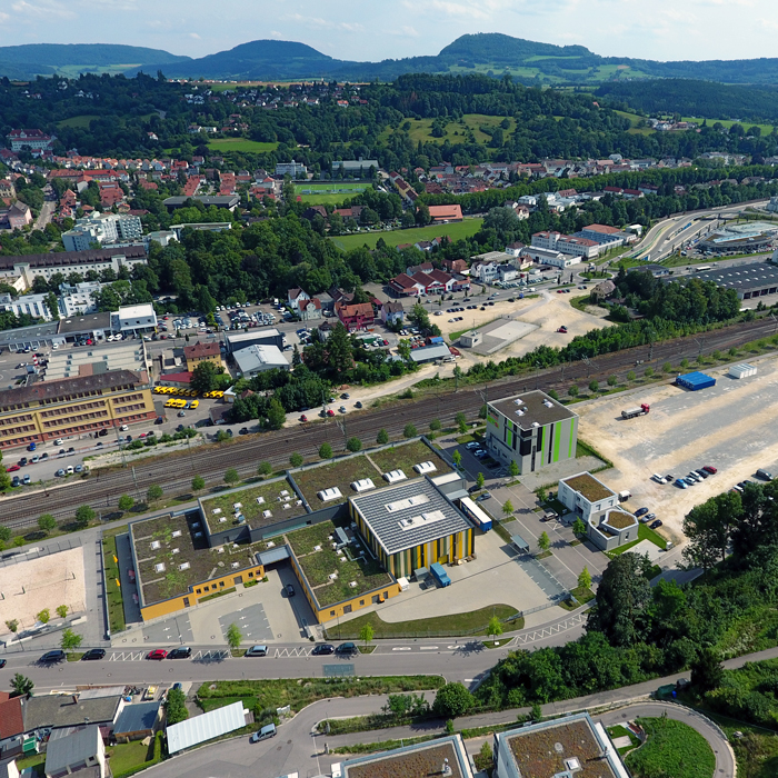
The ‘Western Gateway’ urban development area extends north–south from the railway line to the River Rems and east–west from Hauffstrasse to Vogelhofstrasse.
The parts of the project area south of the railway line, around Lorcher Strasse, have lain fallow for years, despite their importance for urban development. They are adjoined by the green space of Gleispark and the Nepperberg, north of the railway, and the River Rems along their southern edge. The Gleispark area borders the play and sports areas developed for the State Garden Show of 2014. East of these areas are the railway station and central bus station, and the town centre and old town can be reached on foot in ten to fifteen minutes.
The areas have great urban development potential, are conveniently located for all forms of mobility, and would be suitable for a wide variety of uses.
It is important to bring to these potential areas a new development outlook that carries the dynamic urban development of the last ten years forward in spatial terms.
Coordinated development of the project site seems sensible in terms of content and concept and also of function. The urban structures with green spaces that have evolved through urban redevelopment and the State Garden Show could expand westwards here.
How Must Metabolism and Inclusivity Be Developed and Connected?
One urban development goal is a suitably designed town image that presents Schwäbisch Gmünd as a larger medium-sized town and a medium-sized centre with regional sub-functions in the East Württemberg region of the Stuttgart administrative district. The currently underused and partially derelict part of the project site needs transforming into a lively, diverse, and sustainable neighbourhood. An area currently used for large-scale commercial purposes, its design subordinated to car traffic and the automobile trade, needs a future concept with realizable building blocks. The goal is a lively and future-oriented district that becomes part of the town centre and at the same time makes an interesting and inviting entrance to the town.
A plan should also be developed simultaneously for completing the Green Belt ring from the Salvator to the Nepperberg via the Gleispark district, with a ‘green leap’ over the railway to the tunnel site and a southward connection to the other bank of the Rems.
The area needs a long-term urban development process that can be implemented step by step. Its aim should be to develop a mixed district where building groups, housing cooperatives, service providers, and new production facilities all find a place.


Questions on the site
Where does the requirement come from that it has to be essentially a symmetrical four to four-and-a-half story enclosed building structure, and can it be deviated from? Can you provide us with the study results on this?
An asymmetrical composition of the portal building has already been studied and is considered very difficult, therefore proposals for a two-sided portal with symmetrical basic compositions are sought.
A planning with a tower is available and is partly seen very critically, therefore alternatives to the tower are desired and sought. Comment from Europan: Hr. Mihm said in the site visit that, if it is necessary and fits the site, the building could also be higher.
Why is an asymmetrical composition of the portal construction not considered purposeful? Why is exclusively a symmetrical portal construction desired? Why is a tower excluded? Can you provide us with the study results on this?
An asymmetrical composition of the portal building has already been studied and is considered very difficult, therefore proposals for a two-sided portal with symmetrical basic compositions are sought.
A planning with a tower is available and is partly seen very critically, therefore alternatives to the tower are desired and sought. The study can be found in the file new materials.
Which innovative mobility concepts already exist in Schwäbisch Gmünd? And what experiences has the city made with them?
The public transport system in Schwäbisch Gmünd is of a size below the threshold of interval transport. The central distribution point of the ÖPVN is located at the train station and the adjacent ZOB. This hub is adjacent to the planning area. There are car and bike-sharing, these stations will be expanded and further supplemented by mobility stations distributed over a large area. The improvement of bicycle traffic is currently being examined through the designation of bicycle lanes.
Can the plans from the design of the Zeitwerk project including the open space design plan be made available digitally?
The planning here is only at the very beginning. Therefore, there are only first non-binding concepts so far. The documents (PDF) from the May 7 presentation could be made available.
How much are the existing auto operations to be expanded? Are there already concrete space programs / sqm specifications for this?
We have no specific plans for expansion or area sizes on the part of the car companies. The aim of the design was to show a step-by-step long-term transformation of the areas used by car companies into a colorfully mixed district, including areas for the start-up scene and knowledge-based services in the context of the current technological-industrial transformation: Human-Machine Interaction, sensor technology, medical technology, environmental technology, etc.
Can the plans for the senior center and the residential development in th Schwerzerallee and Fehrle Gardens , including open space design plans, be made available?
A plan of the Fehrle Gardens (PDF) with site plan, outdoor facilities and views can be provided. We do not have the documents from the senior citizen facilities and the residential development, as these are private areas.
To what extent does the red area under consideration need to be addressed in terms of urban planning and open space planning?
The area under consideration does not have to be processed in terms of design; what is important are the references and linking elements with the planning area.
Can the cadastral file also be provided as a 3D model, or at least partial areas? Or can the ridge lines, eaves heights and storeys be made available?
See question and answer above (with download link). Additional material can be found in the "New Documents" file on the server.
Can the floor plans, sections and elevations of the zapp, bifora and city bus building be made available?
The views and sections that the city has from building applications can be scanned and made available. Since these are all private buildings, we cannot pass on floor plans.
Are there biotopes in the planning area?
Since this is an inner-city area, no biotopes are mapped in the project area only at the very edge of the northwestern area on the green slope of the Nepperberg. A map showing the biotopes will be provided.
Tunnel area: What is the maximum height for vegetation?
We do not have any information on this.
Can the manhole cover plan be made available?
Yes, a map can be provided (see folder new material)
Has there already been public participation in the Weststadt and are there already wishes, comments or ideas from citizens on its use or design?
There has not yet been any citizen participation for this area.
Do we still receive the story plan of the area under consideration as agreed?
Plan will be provided (see additional download-material)
What is the current occupancy rate of the car parks?
Information on car park occupancy can be provided.
Where does the traffic via Lorcher Straße come from (e.g. commuters in and out) and where should it go or what is the destination? Which means of transport are used (car/public transport/bicycle)?
The traffic in Lorcher Straße comes into the city centre from the west once via the B29 from the direction of Stuttgart and from the northwest from Großdeinbach. This is primarily traffic with destinations in the city centre (work, shopping, services, etc.). The main means of transport here is still the car; the goal is to increase bicycle traffic in this area as well.
Does the little stream Mühlbach (which is marked on the site plan) still exist?
The "Mühlbach" is only an open ditch in a small section, otherwise it is blocked. However, it carries almost no water any more, so that a complete opening would not really make sense.
Are there historic photos of the side and its buildings. e.g. from reports for the protected buildings? And if so, can they be made available?
As far as we could find documents, they are on the Europan server. However, they are not really historical pictures.
Are current studies on commuters and their modal split available for Schwäbisch Gmünd / the site?
Unfortunately, there is currently no evaluation of the modal split. We started to have a traffic analysis carried out at the end of 2019, but it could not yet be completed due to Corona. Data on the modal split will probably not be available until autumn. At present, we can only refer to the commuter data listed in the download Folger (New Documents).
What is the prognosis on housing demands by segments? Is it know, what living typology are desired?
There is a broad demand for different flat sizes. We are also open for new housing concepts like cluster flats or communal rooms. For the segment of micro-apartments or one-bedroom flats, projects are still being completed, there is probably no demand for these any more.
Could you upload the breakout session form the kick off?
The breakout sessions where not recorded.
Is there a drawing for topography lines? There isn't one in the topography file, neither in the general drawing?
In the documents we provided to Europan, the contour lines are included in the cadastral plans, both in the PDFs and in the DWG files.
Unfortunately, the labelling of the layers is not so clear here:
GTI_BEB_6290202 = contour lines (5, 15, 25, etc.).
GTI_BEB_6290203 = contour lines (10, 20, 30, etc.)
GTI_BEB_6290204 = contour lines
If you still need contour lines in 1m-steps we would have to provide them, but this would only be possible for a smaller section.
We have compiled the following data on the Europan Server (Folder New Documents):
-views, sections Bifora Haufstraße 2
-views, sections Zapp Areal Stuttgarter Straße 3
-floor plan Stadtbus Lorcher Straße 64 (no sections and elevations available)
- "Historical" pictures
I have found the following data:
-Roof areas from the solar roof potential survey Roof areas.
-Digital terrain model 1m raster of the LGL DGM1
-3D building model (3D-SHAPE & CityGML) of the LGL LOD2
This site is connected to the following theme
Recovery New energy has to be found for these sites through a treatment that respects the existing environment introducing specific elements and actions able to develop a resilient city.
Dynamizing Landscapes
These sites present a potential to develop a landscape that strongly animates new developments, granting them qualities in the sense of creating a living milieu, integrating rich biodiversity in the realm of public spaces.
Specific documents
Questions on the site
You have to be connected –and therefore registered– to be able to ask a question.
Fr. 16 May 2025
Deadline for submitting questions
Fr. 30 May 2025
Deadline for answers
Before submitting a question, make sure it does not already appear in the FAQ.
Please ask questions on sites in the Sites section.
Please ask questions on rules in the Rules section.
If your question does not receive any answer in 10 days, check the FAQ to make sure the answer does not appear under another label or email the secretariat concerned by the question (national secretariat for the sites, European secretariat for the rules).