Trondheim (NO)
The Synthetic Site Folder and Site Brief are available for free.
Please register and login to access the Complete Site Folder.
- Synthetic site folder EN
- Site Brief EN
- Complete site folder
- Site on Google Maps
- Back to map
Data
Trondheim (NO)
Scales L/S
Team composition Architect mandatory
Location Trondheim municipality
Population 214 000 inhabitants
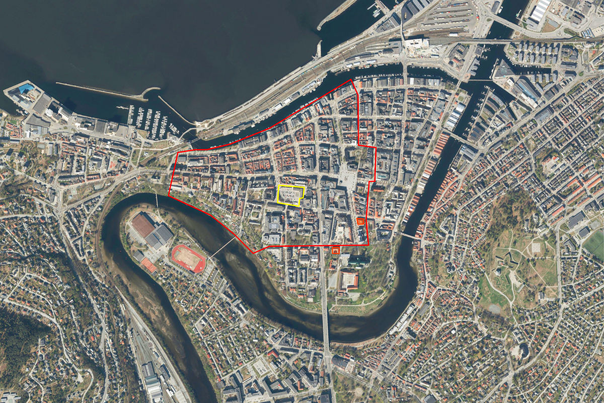
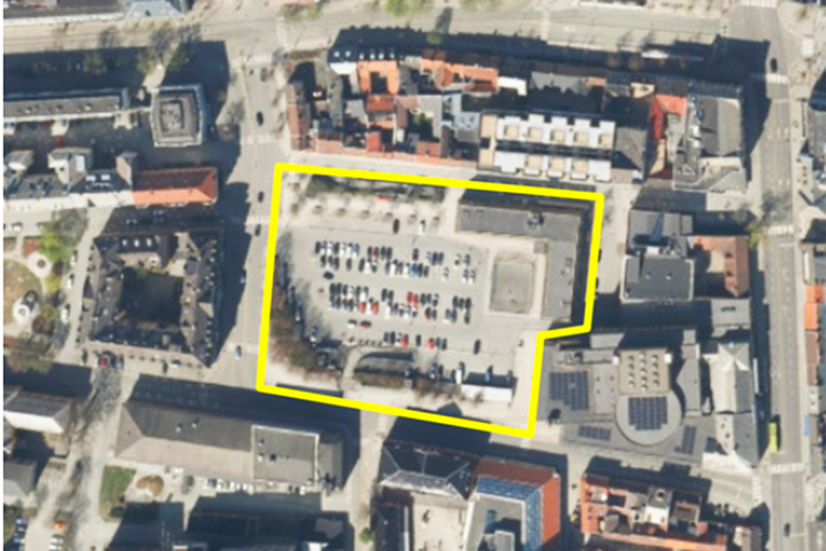
Reflection site 59 ha - Project site 0,9 ha
Site proposed by Museums of Southern -Trøndelag (MiST)
Actors involved The Museums of Southern -Trøndelag (MiST), Trondheim municipality, Trondheim county
Owner(s) of the site Trondheim municipality
Commission after competition MiST has the intention of awarding the winning team a follow up contract to develop the proposal further.
More Information
SITE / CONTEXTE
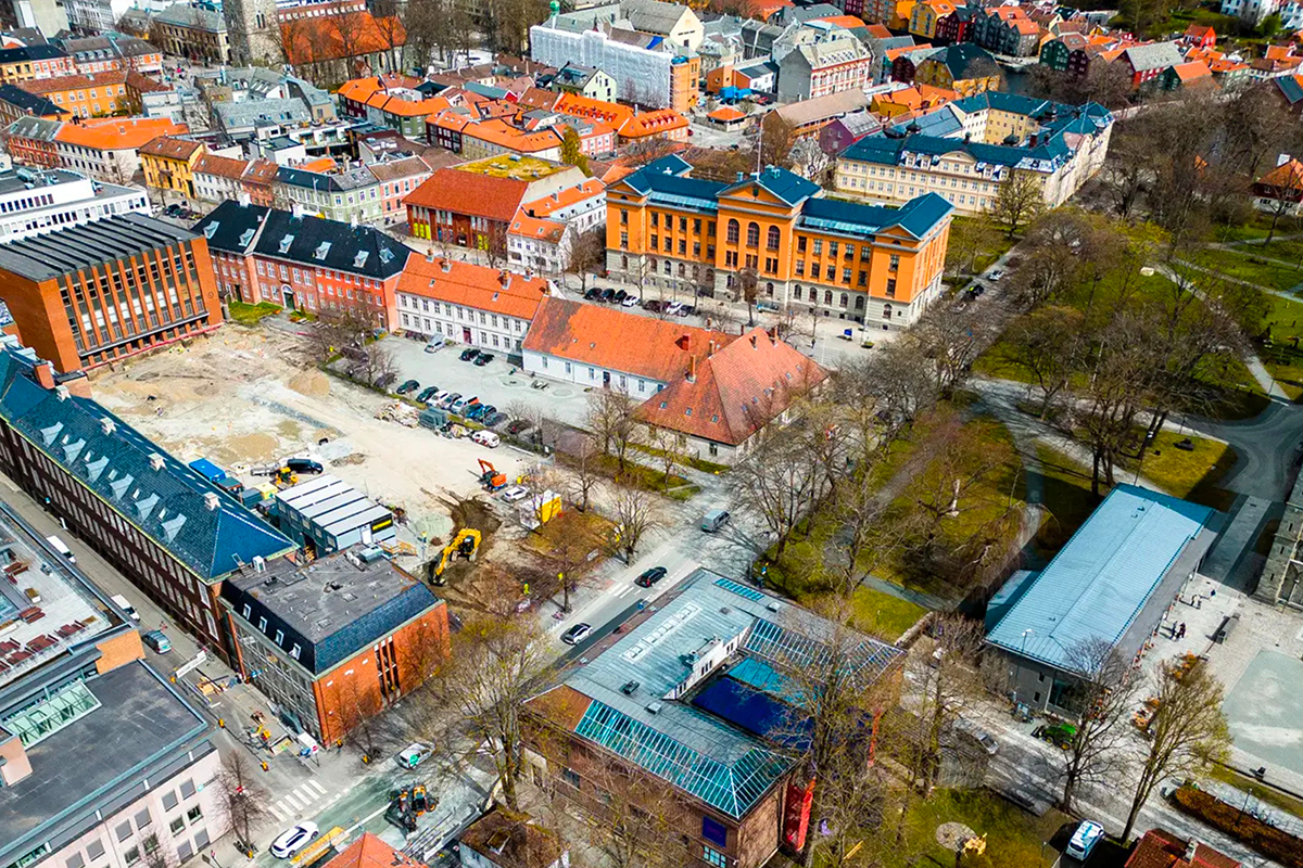
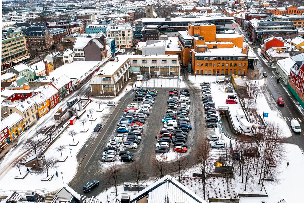
This competition is about making a proposal for a new extroverted building to house Trondheim's two public art museums and with it, a new public space that can help revitalize an isolated part of the downtown, and develop a new cultural square in Midtbyen.
Trondheim art museum and Nordenfjeldske Kunstindustrimuseum National Museum of Decorative Arts and Design are at a crossroad. They both reside in small introverted buildings that are not up to the task of preserving their collections safely, nor do they have space to do outreach, borrow art from elsewhere, do events or in other ways engage sufficiently with the public at a time where the participatory role of the museum is becoming ever more important.
Since 2006, the public authorities and the museums have investigated a myriad of different solutions, ranging from renovations, additions, and a new building(s) in different locations around the city. The existing two sites are both cramped, and located in the historic district connected to Nidarosdomen, Norway's national sanctuary, which adds many restrictions on expansion due to heritage law.
Instead, several reports point to the benefits of relocating both of these museums together in a new building downtown. The existing buildings are perhaps better suited to accommodate other programs with less complex needs. The benefits of relocation are many: spaces built to accommodate the needs of modern museums, an architecture that can be more transparent and allow for hosting more events, temporary exhibitions, workshops and public programs that are inviting for new and younger audiences, all in a more efficient organization structure.
Furthermore, the new museum building can create synergies with other artistic, cultural and commercial activities in the city and provide a much needed infrastructure for Trondheim's fragmented art scene.
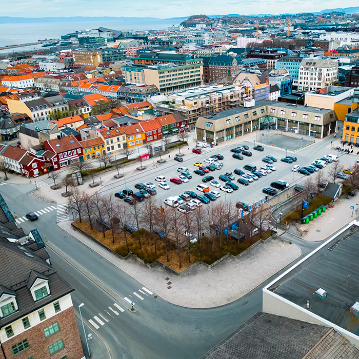
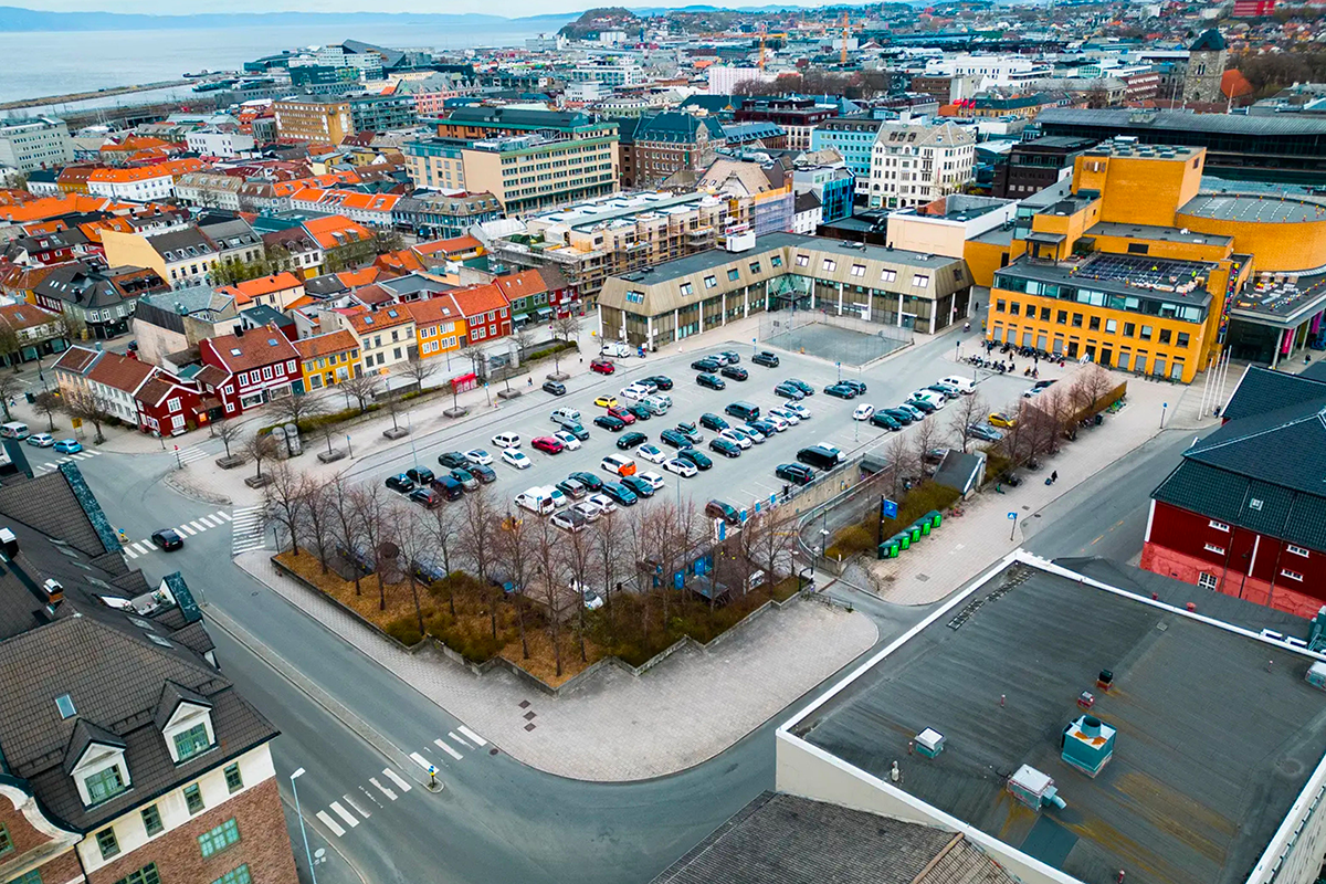
The selected site is a parking structure next to the Trøndelag theater, across from a busy artery road that divides the downtown. The new museum building can provide this part of town a much needed public space, in synergy with neigboring institutions. This could create a pull factor to help revitalize a slightly undeveloped part of downtown and give Trondheim a museum that is the city worthy.
QUESTIONS TO THE COMPETITORS
This competition draws attention to the evolving societal role of the art museum, and their responsibilities in a world of rapid change. Equip the museum to take on its expanded societal role, encouraging synergies with neighbouring institutions, as it merges their two existing museums of arts and crafts. With this in mind:
(1) How does an extrovert museum with adjacent public spaces engage with its surrounding city, its neighbours, inhabitants, and passers-by?
(2) How can the existing structure of over and underground parking be considered and potentially adapted, retained, or reused within a new building design?
(3) How can we find ways to include additional partners, programs, and functions, to reflect the museum's extroverted role, on a site that is generous enough to accommodate more than just the museum itself?

Questions on the site
Could you provide a .dwg file with the planimetry of the city of Trondheim, or at least the work area, at scale L? Thank you.
We have uploaded a package containing large-scale map data for the city of Trondheim and the project site. The dataset includes DWG files, GIS layers, 3D models, and orthoimagery.
You will find it in the folder Large Scale Map, located in the 0_New_Docs_after_launch folder.
The folder contains:
-
autocad/ – DWG files with planimetry and base map data
-
arcgis/ and gdb/ – GIS database files (ESRI format)
-
ortofoto/ – High-resolution orthophotos of the area
-
ifc/ and wavefrontobj/ – 3D model formats
-
3ds/ – 3D Studio-compatible model files
-
laser/ – Laser scan data
Please refer to the autocad folder for DWG files specifically, but the additional formats may also support your workflow depending on software used.
Should we take into consideration the expansion project of the theater, which is in the limit of the museum site? Or can we imagine something else for the expansion of the theater?
The current expansion project for the theater should be considered as fixed. However, there is some flexibility regarding the outdoor areas and the stage, which can be re-evaluated or redesigned as part of the competition proposal.
The NO-Trondheim-PS-M2 file includes a parking lot drawing. Does this drawing match the current underground parking situation, or is there a more updated version available? Should we proceed with the design based on the provided parking lot drawing?
Use the provided drawings.
It is mentioned that the reuse of the parking lot should be considered, but at the same time, it is stated that reinforcement of the current structural condition is necessary. Does this mean that reusing the parking lot is a prerequisite, or is it simply a consideration to keep in mind?
It is not a prerequisite. It means that it is desirable from a sustainability perspective to reuse the concrete structure if possible.
Are there any height restrictions for buildings on the given site?
The current zoning plan specifies a maximum height of 32,3 - 24,9 meters above sea level on different parts of the site. However, a new plan will have to be made before the museum can be built. For the sake of this competition there are no specific height restrictions. But show care and consideration towards the surrounding urban fabric. The current zoning plan has been uploaded to the "new documents after launch" folder and can be used as a reference.
In the function program, a total of 9200 sq.m. is outlined. Does this area measurement refer to Net Floor Area (NFA) or Gross Floor Area (GFA)?
The total of 9,200 m² outlined in the function program refers to Net Floor Area (NFA).
What exactly are the final documents of the competition I would like to clarify the requirements for the 3 vertical A1 PDF and what they should contain? What exactly are the requested drawings and images? (Plans, sections, elevations, details, diagrams etc.) I couldn’t find where it is mentioned in the provided documents, could you indicate please?
The requirements for the 3 vertical A1 PDFs are listed in the Europan 18 rules under §4.4 Items to Submit.
There is no fixed list of required drawings (e.g. plans, sections, etc.), but the content should visually and clearly communicate your proposal across scales. All drawings must include a graphic scale.
But as is written in the rules the panels must:
- explain the urban ideas developed in the project with regards to the site issues and the thematic orientations of the session;
- develop the project as a whole, highlighting the architecture of the project, and particularly the relationship between the new developments and the site’s existing context, including three-dimensional representations of the project;
- develop the method foreseen for the implementation process.
I found two different tables that differ from each other about the total square footage of the building. ("NO-Trondheim-KVU_1-T" p.58 and "NO-Trondheim-KVU_2-T" p.28). Which one should I rely on? What are the final total square meters of the built and unbuilt space (the ratio 1,45 you mention)?
The competition brief contains the correct total square footage in the table under the title "Function program". This document outlines the task, guidelines, background and the room/function program with sizes.
KVU1 and KVU2 are previous reports that can be used as background references.
Can you allow a joint download of folder 0-New_Docs_after_Launch?
Europan Norway is not able to solve this from our side. Therefore technical questions like this should be directed to Europan Europe at contact@europan-europe.eu, as they are responsible for managing the server platform across all countries, including Norway.
This site is connected to the following theme
Re-sourcing from social dynamic The “multiple heritage” of derelict buildings provides a precious source for a larger urban transformation, which is launched by interventions that operate first in the scale of the site itself, Integrating social and cultural traces in the sites’ geographical and physical rehabilitation enables an upscaling of the transformation’s impact. It can induce a second life whose urban energy radiates far beyond its physical limits.
Inducing a Second Life
Questions on the site
You have to be connected –and therefore registered– to be able to ask a question.
Fr. 16 May 2025
Deadline for submitting questions
Fr. 30 May 2025
Deadline for answers
Before submitting a question, make sure it does not already appear in the FAQ.
Please ask questions on sites in the Sites section.
Please ask questions on rules in the Rules section.
If your question does not receive any answer in 10 days, check the FAQ to make sure the answer does not appear under another label or email the secretariat concerned by the question (national secretariat for the sites, European secretariat for the rules).