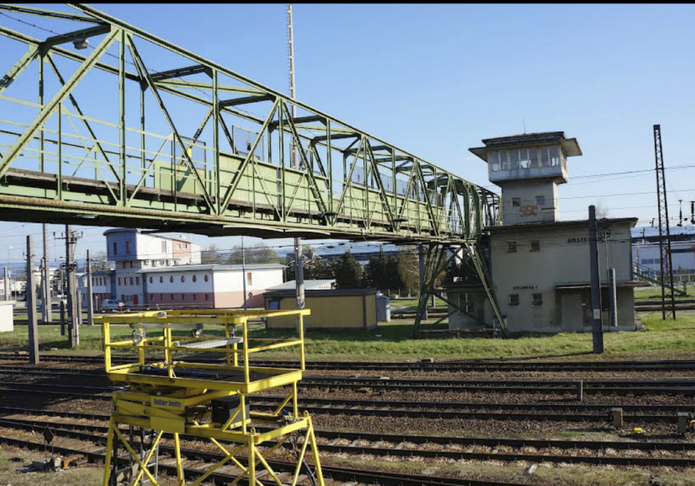
Amstetten
The Synthetic Site Folder and Site Brief are available for free.
Please register and login to access the Complete Site Folder.
- Synthetic site folder EN
- Site on Google Maps
- Back to map
Data
Category urban
Team representative Architect - urban planner - landscaper
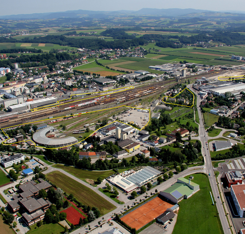
Location Amstetten – Lower Austria
Population City 23,000 inhab. - Conurbation 110,000 inhab.
Strategic site 117 ha - Site of project 1.8 ha / 0.6 ha / 5.6 ha / 1.2 ha / 1 ha
Site proposed by City of Amstetten & ÖBB Austrian Railway Company
Owner(s) of the site ÖBB Austrian Railway Company
Commission after competition Urban project management role, further involvement in architectural follow-up procedures
More Information
How can the site contribute to the adaptable city?
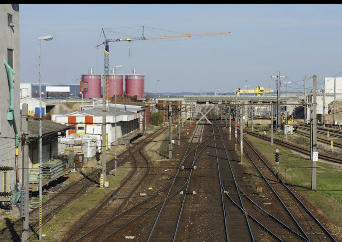
The train has been playing an important role in the development of the city: the main east-west line of Austria runs through the town. Due to technological and logistical adaptations the railway company can offer parts of their terrain for urban development. The city can take advantage of this opportunity and adapt its border to the railway as a productive limit with 2 faces, one directed to the city, the other one to the trains.
City strategy
The city is concerned with its eastern and western entrance points to the inner city. They are important visible interfaces, not only between train and town but also between the consolidated inner city and the surrounding areas. A main concern and potential is the city‘s ambiguous relation to the train as a public and technical corridor, as a connecting and separating element, as a „machine“ that blocks and enables panoramas of the town, and, above all, as a sustainable means of transport that networks the economy of the city.
Site definition
Amstetten profits strongly of its station which is part of the most important east-west train connection, the „Westbahn“. The territory of the railway not only occupies but also characterizes the extensive land of the commune which stretches along the railway course. The historical town has been growing eastwards, incorporating the main station area, around which the site is located. Fragments of industrial, commercial and housing developments, as well as main traffic infrastructures characterize this entrance point of the city . A series of fragments around the railway station form the competition area at the fringe between train and town. An overall urban strategy, able to create a new added value needs to be developed.
It is important to perceive Amstetten’s new geography: a central place between Salzburg and Vienna, linked with numerous towns, countrysides, and even 2 airports (Linz and Vienna). Second, it is important to give an identity to this new geography: to materialize on the local level the convenience of its geography. If Amstetten is one of the best connected towns in Austria, it also has to become one of the most livable towns: attractive and connective…
Seen in this light, it is absolutely important to develop an overall strategy – “a common sense” – for the fragmented areas, to see their tasks in an overall development-concept which will redefine the relation between the city and the railway. In order to avoid a purely formalistic approach whose common sense is based exclusively on typological or all too obvious similarities, the physical, the programmatic and the cultural relationship have to be studied.
Adaptability : main elements to take into account
3 main aspects:
- the positive tension between the railway space and local qualities, including possible feedback processes for the mutual development
- the question of uses and its possible elasticity, especially concerning the challenging fringe conditions
- the issue of development in time considering the independent development of the different pieces, as well as unforeseeable dynamics concerning the restructuring of the area.
Questions on the site
We cannot download all the files: when we try to download the files of the folder called 'New docs after launch' it links to an error 'Sorry the page could not be loaded'
The problem is now corrected.
Site 3 / 3a page 18 : “due to the existing rail tracks (used for trade) between site 3 and 3a and the existing electric power transformation substations, there is only a pedestrian and bicycle connection possible for linking this site with the site 3” 1. Does it mean that we cannot create any vehicle access to the site 3 from the east?
2. Is it thinkable to create a grade crossing (bahnübergang) to connect the two sites?
3. Are the electric power lines not high enough for cars to pass under?
1. Yes, as written in the brief, the access/infrastructural entrée (for cars) of site 3 has to be located in the western part of the site, north of the water tower and in the south of the engine shed, connected to Eggersdorferstraße. (page 16 in competition brief)
2. In general it is not possible to build above or below rail-tracks! Please see written in the minutes of the site visit:
Q6: Participant: There is only one access (in the west, next to the watertower) planned to site 3. Is it possible to create another option of access in the east of the site?
A6: ÖBB: No, first there is an electricity plant in the east of project site 3, so you cannot cross here because of the infrastructural barrier. Second, there are rail tracks which are still used for the Lagerhaus, so it is not legal to cross them.
A6: Europan: All the same, as written in the competition brief, do not exclude thinking about connectionsbetween project site 3 and 3a! Once it is liveable there, people will cross anyway. So the task is to define along-term strategy to link! … a link can also be soft for pedestrians… In general it is essential that it is not possible to build above or below rail-tracks!
3. In general the electric power lines are high enough for cars to pass under. But as the electric power transformation substation will stay in use, there should be no focus on cars passing there.
Is it possible to get a dwg/dxf file which includes 100% the whole strategic site?
No, there will not be an additional dwg/dxf file. It is only a little part in the north missing, this is not important in the competition.
This site is connected to the following theme
Heritage of the Future Heritage is generally thought to look back to the past, but conversely it could be said that it should look to the future. Heritage is usually considered to be extraordinary, but is there not a case for thinking about the definition of “ordinary heritage”? Heritage is customarily perceived as an architectural object, but this office will explore ways to “create heritage” in three types of context where it is in principle lacking: the transformation of orphan districts, the conversion of neglected buildings or plots, the redevelopment of abandoned industrial zones or enclaves.
It can be hypothesised that the more the city, in both its morphology and its functions, spans, recaptures and expresses the eras and phases of its development, the more it develops its capacity to adapt to change, its potential for urban adaptation and its ability to resist sudden crises. So the question is: does creating heritage mean increasing the capacity to adapt the future city?
Questions on the site
You have to be connected –and therefore registered– to be able to ask a question.
Fr. 16 May 2025
Deadline for submitting questions
Fr. 30 May 2025
Deadline for answers
Before submitting a question, make sure it does not already appear in the FAQ.
Please ask questions on sites in the Sites section.
Please ask questions on rules in the Rules section.
If your question does not receive any answer in 10 days, check the FAQ to make sure the answer does not appear under another label or email the secretariat concerned by the question (national secretariat for the sites, European secretariat for the rules).