Bitterfeld-Wolfen
The Synthetic Site Folder and Site Brief are available for free.
Please register and login to access the Complete Site Folder.
- Synthetic site folder DE | EN
- Site on Google Maps
- Back to map
Data
Category urban-architectural
Team representative architect / urban planner / landscaper
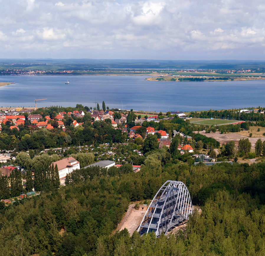
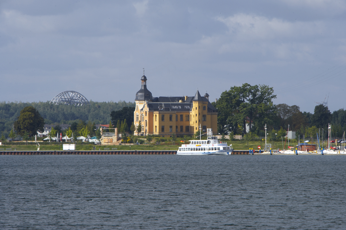
Location Bitterfeld-Wolfen – Garden City and Town Quay
Population ±43,900 inhabitants
Strategic site ± 269 ha - Site of project Garden City South 15.6 ha / Town Quay 17 ha
Site proposed by Bitterfeld-Wolfen Town Council
Owner(s) of the site Bitterfeld-Wolfen Town Council (approx. 1/3), LMBV (approx. 1/3), private owners (ca. 1/3)
Commission after competition Urban master plan, possibly individual construction projects
More Information
How can the site contribute to the adaptable city?
The former chemical region of Bitterfeld-Wolfen has undergone fundamental structural changes since 1990. A successful transformation process was initiated with the new Goitzsche recreational landscape and “Technology Park Central Germany”, and this is to continue. The links between Bitterfeld town centre and the nearby Town Quay on Goitzschesee will be completed in the foreseeable future. Now the issue at hand is to determine the shape and extent of reorientation of Bitterfeld town centre with a sustainable urban expansion around the Goitzsche. The two wasteland sites in Garden City and at Town Quay offer outstanding development potential in this respect.
City strategy
The vision of Bitterfeld Town Council is the development of the town as a complex residential, living and residential centre. This vision has started to materialise with the development of valuable new potential around Goitzschesee. The town should not only be a place to live and work, but become a new form of “place to live”. This vision is to be realised not only in single construction measures, but also in the town’s self-expression. The revitalisation of the Gartenstadt Süd and the area between Town Quay and Villa Bernsteinsee will be an opportunity to create new housing typologies and attractive sports and recreational concepts whose quality and appeal go beyond the present amenity level and attract new residents.
Site definition
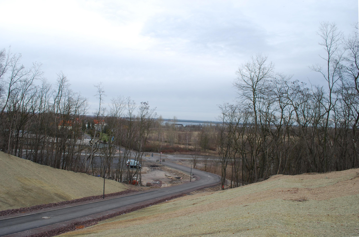
The wasteland in Garden City, characterised by suburban development and some villa-style houses, lies on the southern fringe of the town. The proximity to Bitterfeld town centre (800 m), shoreline of Goitzschesee (600 m), “Grüne Lunge” town park and Goitzschewald (forest) holds considerable potential. The area is currently being provided with a new access road. This area has become a focus of urban growth due to the development of the Goitzsche to create an interesting tourist and recreation area. The Town Quay project area is located close to the Auensiedlung on the eastern fringe and separated from the latter by federal highway B 100. In the land use plan this area is designated for sports/recreation and open space.
Adaptability : main elements to take into account
Bitterfeld-Wolfen is the most industrialised medium-sized town in the administrative district. With the Goitzschesee – created by flooding in 2002 and meanwhile known beyond the regional boundaries – and Goitzschewald the town has acquired enormous recreation potential and landscape quality. However, it is struggling with the effects of shrinkage as well as demographic and economic structural change. It is striving to attract new resident groups in the long term by becoming a centre for living, working and recreation. For this purpose new, cross-generation forms of living must be provided as alternatives to the classic single-family dwelling on virgin land.
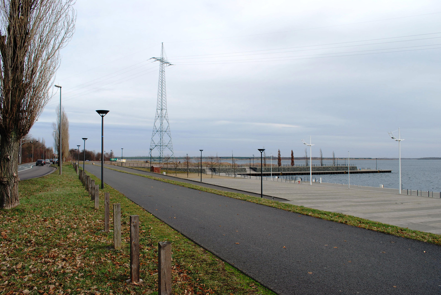
The new approach is to develop housing and apartment typologies that demonstrate a strong relationship to the landscape and offer infrastructural prerequisites for sports-minded families. Whilst the public open spaces should preserve their landscape character, they should also promote identification with the residential area and Goitzschewald as a place of social interaction. The direct connection between living with leisure and recreational functions should enhance its appeal. For the Town Quay site, on the other hand, the emphasis of development should be placed on a wide variety of uses with attractive leisure and recreational water-oriented opportunities. The main intention is to enhance the profile of the "Goitzsche" tourist location as a whole and in the long term.
Questions on the site
There is JPG, PDF and DWG. Is there a 3D file available, a model 3D of the sites in the file?
Sorry, no.
There is no 3D model on the file. Is it possible to have it?
In the folder "New_docs_after_launch" you can find a map with contour lines: BITTERFELD-WOLFEN-DE-SS-M2.dwg.
Is this possile to change the planning program of project area B?
Can you please precise your question. What kind of change?
Which language have to use for the A1 and A3 pannels?
English (and/or German additionally).
Area B mastrerplan has a conventional definition of functional areas. Is it possible to change it according to Europan topics? in particular it's possible to design a different interface with the lake, and between lake and city? Projektgebiet B hat eine sehr konventionelle Definition der funktionalen Flächen. Ist es möglich, dies in Relation zum Europan-Thema zu ändern? Genauer: ist es möglich, einen anderen Anschluss an den See und zwischen See und Stadt zu planen?
Proposals for a design of the lakeside area and a better connection between Goitzsche and the city are desired. The waterfront zone must be kept free of buildings, which is specified in the master plan.
Another connection to the lake is not desired. The waterfront was built for several million Euros. The connection between the inner city and the city harbour was part of another competition. If there are reasons to differ from the winning proposal (BITTERFELD-WOLFEN-DE-C-M18.pdf), it is possible to make an alternative proposale.
Ein anderer Anschluss an den See ist nicht gewünscht. Die Wasserfront ist mit mehreren Millionen gebaut wurden. Die immer noch desolate Verbindung zwischen Innenstadt und Stadthafen war Gegenstand eine Planungswettbewerbes „Zwischen Innenstadt und Stadthafen“2008. Gibt es gewichtige Gründe vom Siegerentwurf (BITTERFELD-WOLFEN-DE-C-M18.pdf) abzuweichen, kann gerne ein Alternativvorschlag gemacht werden.
Hello, 130 150 residential units is a very low density for the zone A area. Can we densify more? In the program, you talk about 10% of residential studios for the zone B. It is 10% of what? Thank you in advance for your answer. Projektgebiet A: 130-150 Wohneinheiten ist eine sehr geringe Dichte für das Projektgebiet. Kann eine höhere Dichte vorgeschlagen werden?
Due to the decreasing population: No. A larger designation of building land would probably not being approved by the city. For zone B: 10% of the units you are planning.
Angesichts der rückläufigen Bevölkerungsentwicklung: Nein. Eine größere Ausweisung von Bauland würde der Stadt sehr wahrscheinlich nicht genehmigt werden. Für Zone B: 10% von den geplanten Flächen.
Hello, is this possible to have a map with the point of view of the picture in the files? is this possible to have more pictures of the sites? Ist es möglich, eine Karte mit den Aufnahmepunkten der Fotos zu bekommen? Ist es möglich, mehr Fotos der Gebiete zu bekommen?
Points of view cannot be provided. From what do you need more pictures of?
Aufnahmepunkte können leider nicht genannt werden. Wovon sollen mehr Fotos geliefert werden?
Did they fully excavate the lignite? How is the structure and composite of the soil? Is it clay, sand or both? Wurde die Braunkohle vollkommen abgebaut? Wie sind die Struktur und die Zusammensetzung des Bodens? Ist es Lehm, Sand oder beides?
See map BITTERFELD-WOLFEN-DE-C-M17.pdf.
Siehe Karte BITTERFELD-WOLFEN-DE-C-M17.pdf.
What are the soil’s requirements? Is it remediated? Is it possible to excavate the soil or could a potential contaminated layer be exposed with this? Was sind die Erfordernisse im Umgang mit dem Boden? Ist er saniert? Ist es möglich, Boden abzutragen oder werden damit potenziell kontaminierte Schichten frei gelegt?
Assume that contaminated soil will be exposed due to excavation.
Es ist davon auszugehen, dass bei Grabungen kontaminierte Böden frei gelegt werden.
What happened with the mining companies? Do they still participate now? This because they did take part during the restructuring. Was ist die heutige Rolle der Bergbaugesellschaften? Es ist erwähnt, dass sie an der Restrukturierung beteiligt waren - sind sie es noch?
The LMBV is responsible for the follow-up care of the surface-mining areas and the commercialisation of the areas.
Die LMBV betreibt an der Goitzsche die Nachsorge der Tagebaue und Vermarktung der Flächen.
What is the established masterplan as mentioned on page 35?
See Masterplan 1/99a and b on page 42 in the competition brief. You can find the masterplans also in the folder project site, maps: Bitterfeld-Wolfen-DE-PSB-M4/M5.pdf.
What is the "special written document" mentionned on page 42? Was ist das 'Spezielle Dokument', das auf Seite 42 erwähnt wird?
As a result of the competition "between inner city and city harbour" in 2008, the goals for 2009 were formulated. These goals are not part of the competition as they do not apply for the project areas.
Im Ergebnis des Planungswettbewerbes „Zwischen Innenstadt und Stadthafen“ 2008 wurden die Sanierungsziele 2009 fortgeschrieben. Diese Ziele beziehen sich aber nicht auf das Wettbewerbsgebiet.
Who or what is the owner of the sites regarding the plan? Wer ist Besitzer der Grundstücke, die im Plan ausgewiesen sind?
More detailed information than shown in maps: BITTERFELD-WOLFEN-DE-PSB-AdditionalDok5.pdf and BITTERFELD-WOLFEN-DE-PSA-AdditionalDok2.pdf cannot be made due to privacy protection.
Genauere Angaben als in den Karten: BITTERFELD-WOLFEN-DE-PSB-AdditionalDok5.pdf und BITTERFELD-WOLFEN-DE-PSA-AdditionalDok2.pdf können aus Datenschutzgründen nicht gemacht werden.
Are there height maps available?
Yes, see Bitterfeld-Wolfen-DE-SS-M2/M3.dwg in the folder new docs after launch.
Are there also flow diagrams available of the existing waters? Gibt es Fließdiagramme der bestehenden Seen?
No, to this point nobody seems to deal with this.
Nein, damit hat sich wohl noch niemand beschäftigt.
Is it true that mining is still going on and that new mining areas are still assigned? This is what we read on the c-m11 map ‘surface mining requested’; what is the present role of the mining companies? Stimmt es, dass der Tagebau noch in Betrieb ist und neue Abbaugebiete gesucht werden? Das entspräche dem, was wir aus der Karte BITTERFELD-WOLFEN-DE-C-M11 (Antragsbereich Tagebau LMBV) herauslesen; was ist die momentane Rolle der Bergbaugesellschaften?
No, the coal surface-mining is not in service any more. The areas in the map are usual gravel mining areas. The LMBV is responsible for the follow-up care of the surface-mining areas and the commercialisation of the areas.
Nein, der Kohletagebau ist nicht mehr in Betrieb. Die bewilligten Felder auf der Karte sind herkömmliche Kiesabbaugebiete: Die LMBV betreibt an der Goitzsche die Nachsorge der Tagebaue und Vermarktung der Flächen.
What do the displayed signs on the c-m16 map ‘TOTOGRAPISCHE KARTE BITTERFELD OST 1904-1936’ mean? Was bedeuten die dargestellten Zeichen im Plan BITTERFELD-WOLFEN-DE-C-M16 (‘TOPOGRAPHISCHE KARTE BITTERFELD OST 1904-1936’)?
We assume that the excavated villages are meant.
Vermutlich sind damit die weggebaggerten Dörfer gemeint.
After the flooding 10 years ago a new embankment (dam/dike) was constructed, did this reduce or passed the flooding risk in the area? Nach der Flutung vor 10 Jahren wurde ein neuer Damm/Deich errichtet. Hat dieser das Überflutungsrisiko reduziert oder minimiert?
The flood prevention was considerably improved.
Der Hochwasserschutz wurde erheblich verbessert.
It is written that the groundwater is still contaminated –for the next 100 years- does this also apply for the surface water of the lakes in the area? In der Auslobung steht, dass das Grundwasser immer noch kontaminiert ist und das für die nächsten 100 Jahre - betrifft das auch das Oberflächenwasser der Seen im Gebiet?
No, the Goitzsche lake has bathing water quality.
Nein, der Goitzschesee hat Badewasserqualität.
Is there more information available on the masterplan of several years ago? And if so, where can we find these documents/information? Gibt es genauere Informationen zum bestehenden Masterplan Wenn ja, wo können wir diese Informationen finden (z.B. online)?
The masterplan can be found as BITTERFELD-WOLFEN-DE-C-AdditionalDok14.pdf.
Der Masterplan liegt als BITTERFELD-WOLFEN-DE-C-AdditionalDok14.pdf bei.
WHAT IS THE EXACT FUNCTION OF THE DAM LOCATED ON THE BERGSTEINWEG? Welche Funktion hat der Damm am Bernsteinweg?
Flood prevention.
Hochwasserschutz.
Is there a map of the situation of how the new road is realized? Existiert eine Karte, wie das neue Straßennetz (Gartenstadt Süd) verläuft?
See: BITTERFELD-WOLFEN-DE-SS-M2.pdf.
Siehe: BITTERFELD-WOLFEN-DE-SS-M2.pdf.
There are three comparable .dwg files into the Complete Site Folder: BITTERFELD-WOLFEN-DE-SS-M1 (in Strategic site's folder), BITTERFELD-WOLFEN-DE-PSB-M1 and BITTERFELD-WOLFEN-DE-PSA-M1 (in Project site's folder). Which are the differences among them?
There are no differences in these plans. They are only divided into three different layouts to show the two project areas and the study site.
We could not find any information about flora and fauna around the lake; are there specific issues to be kept in consideration beside the forest’s bioenvironment? Wir konnten keine Informationen zu Flora und Fauna am See finden. Gibt es spezifische Aspekte neben dem Ökosystem des Waldes, die wir berücksichtigen sollen?
There are no information about that field.
Es gibt zur Zeit noch keine Informationen darüber.
Is there any map available for area A showing the ownership boundaries, those that you advise to consider in the phasing process? Gibt es eine Karte für das Wettbewerbsgebiet A, die die Besitzverhältnisse, die nach der Auslobung berücksichtigt werden sollen, zeigt?
Please see the map about the ownership: BITTERFELD-WOLFEN-DE-PSA-AdditionalDok2.pdf
Gemeint ist die Eigentümerkarte: BITTERFELD-WOLFEN-DE-PSA-AdditionalDok2.pdf
Where is it possible to find a local public transport map (routes and stops) of Bitterfeld-Wolfen? Wo kann man eine ÖPNV-Karte von Bitterfeld-Wolfen finden (mit Haltestellen und Routen)?
See: http://reiseauskunft.insa.de bzw. www.vetter-bus.de and BITTERFELD-WOLFEN-DE-C-M19.pdf.
Siehe hierzu bitte: http://reiseauskunft.insa.de bzw. www.vetter-bus.de und BITTERFELD-WOLFEN-DE-C-M19.pdf.
Concerning the map of Area B "BITTERFELD-WOLFEN-DE-PSB-M6.pdf", are the compartments “SO 14” and “SO 20” to be included in the project site area B and so developed as a design task? Zum Plan "BITTERFELD-WOLFEN-DE-PSB-M6.pdf" des Wettbewerbsgebiets B: sollen die Segmente "SO 14" und "SO 20" in das Wettbewerbsgebiet integriert und somit mitgestaltet werden?
For SO20: yes. SO14 should not be integrated (it is outside the competition area).
Die SO 20 ja. Die SO 14 soll nicht integriert werden (sie liegt deshalb außerhalb des Wettbewerbsgebietes).
Do the buildings of the compartment “SO 16” (area B) have to be preserved or is it an option to relocate their function in new buildings? Sollen die Gebäude im Gebiet "SO 16" (Gebiet B) erhalten werden oder ist es möglich, die dort untergebrachten Funktionen in neue Gebäude zu verlagern?
It is a residential building. If the planned new use is a "use with a strong income return rate", a relocation of the inhabitans would be possible. A private investor would have to pay for the relocation.
Es handelt sich um ein Wohnhaus. Handelt es sich bei der geplanten Neunutzung um ein „renditestarkes Gewerbe“ wäre eine Umsiedlung der Bewohner denkbar. Ein privater Investor müsste also die entstehenden Kosten übernehmen.
Is it allowed to make proposals for public space (which means any building) on the strategic site areas, with special reference to the shoreline next to the area B?
Proposals for a design of the lakeside area and a better connection between Goitzsche and the city are desired. The waterfront zone must be kept free of buildings, which is specified in the master plan.
Is it allowed to demolish the parking garages placed next to the north-east corner of area A, in between the two existing soccer fields? Is it possible to replace them with a proper building instead? Können die Garagen an der nord-östlichen Ecke des Areals A, zwischen den beiden bestehenden Sportplätzen, abgerissen werden? Können sie durch "richtige" Gebäude ersetzt werden?
Yes.
Ja.
Is the file 'BITTERFELD-WOLFEN-DE-SS-AP7' showing the latest streetlayout? Is it possible to get the new streetlayout in a bigger frame, with the connection to the city? Preferably as a dwg? Zeigt die Datei "BITTERFELD-WOLFEN-DE-SS-AP7" (Luftbild mit Straße) das aktuelle Straßenraster? Ist es möglich, dieses neue Straßennetz in einem größeren Ausschnitt mit den Verbindungen zur Stadt, zu bekommen? Bevorzugt im dwg-Format?
Yes, it is the actual street layout. See: BITTERFELD-WOLFEN-DE-SS-M2.pdf. Unfortunately it is only possible to provide the plan in .pdf-Format.
Ja, es ist der aktuelle Straßenverlauf. Siehe: BITTERFELD-WOLFEN-DE-SS-M2.pdf. (allerdings nur als PDF möglich ).
Hi, on page 46 you mentioned housing groups and multi-storey residential buildings. Could you explain better the difference between them?
Housing groups are joint building ventures where individuals (the assigned inhabitans) prefinance the buildings and have some influences on room layouts while the multi-storey residential buildings are financed centralised for example by an investor for renting the units later to inhabitans.
In the three dwg file that you sent- the BITTERFELD-WOLFEN-DE-SS-M1.dwg file, BITTERFELD-WOLFEN-DE-PSA-M1.dwg file, BITTERFELD-WOLFEN-DE-PSB-M1.dwg file-in the plans there are no quotas. We ask if you can send us dwg files with an indication of quotas of reference.
Quotas are indicated in the files BITTERFELD-WOLFEN-DE-SS-M2.dwg and 3dwg in the folder "new docs after launch".
The following files (BITTERFELD-WOLFEN-DE-PSA-M2.jpeg file, BITTERFELD-WOLFEN-DE-PSB-M3. jpeg file) that you have not attached the caption or legend of reference. We ask if you can send us the caption or legend of reference. Die Dateien BITTERFELD-WOLFEN-DE-PSA-M2.jpg (FNP) und BITTERFELD-WOLFEN-DE-PSB-M3.jpg (FNP) haben keine Legende oder Beschriftungen. Kann für die beiden Pläne eine Legende zur Verfügung gestellt werden ?
Yes, see file BITTERFELD-WOLFEN-DE-PSA-M2-LEGEND.jpg.
Ja, siehe BITTERFELD-WOLFEN-DE-PSA-M2-LEGEND.jpg.
If we decide to write the text in both languages, english and german, for the A3 document, do we have to submit 2 documents one in each language or 1 document with both languages?
Both languages in 1 document of 7 pages.
Are we allowed to build something outside the project site line, but within the strategic site? Ist es möglich etwas außerhalb des Projektgebietes aber innerhalb des Betrachtungsraumes zu planen ?
Yes, but it should be reasoned in detail or establish a clear connection to the project site.
Ja, es sollte aber ausführlich begründet werden bzw. ein eindeutiger Bezug zum Projektgebiet hergestellt werden.
In the description of the program (pg 42 - Situation under planning law in project area B/ between the town port and Villa am Bernsteinsee), you write "The legally binding master plans nos. 1/99a and 1/99b Bitterfeld Waterfront have existed for project area B since 14 December 2005....”. We would like to know how binding the signs of the detailed plans (1/99a and 1/99b Bitterfeld Waterfront) that you sent, if we stick to the maximum dimensions indicated or we can feel free to change them? We would also like to know if it is possible to intervene by changing the coastline and introduce lake water in the project area. Thanks for your attention Your question In der Beschreibung des Programms (Seite 42 der Auslobung - planungsrechtliche Situation im Projektgebiet B/ Zwischen Stadthafen und „Villa am Bernsteinsee“) steht: "Für das Projektgebiet B existieren die seit dem 14.12.2005 die rechtskräftigen Bebauungspläne Nr. 1/99a und 1/99b "Bitterfelder Wasserfront"". Wie bindend sind die Vorgaben, die in den Plänen dargestellt sind (1/99a und 1/99b "Bitterfelder Wasserfront") ? Müssen wir uns an die maximalen Flächen halten oder können wir diese verändern ?
As long as the transportation infrastructure is respected, a new layout of the areas is possible.
Die verkehrlichen Anlagen sind zu beachten, ansonsten ist eine Neuaufteilung der Flächen möglich.
Site area B: What is the exact height difference between the walkway and the Goitzsche water level? And between the walkway and the floorlevel of the "harbour" at the "Bitterfelder Wasserfront"? Projektgebiet B: Was ist der exakte Höhenunterschied zwischen der Promenade und dem Wasserniveaus der Goitzsche und zwischen der Promenade und dem Grund des Hafens an der "Bitterfelder Wasserfront"?
Approx. 2m, the depth of the harbour is unknown.
Ca. 2 m, Tiefe des Hafens ist uns nicht bekannt.
In Bitterfeld-Wolfen-DE-C-Pr.pdf on pag.10 (thematic content) it’s written (panel 2): “a layout plan (scale 1:500/1:1000)…will be required”. But If I use these scales, both Area A and Area B don’t fit to A1 Panel 2; can I use another scale(eg 1:2000)?
Yes, you are free to use an other scale that fits on A1.
In "Bitterfeld-Wolfen-DE-C-Pr.pdf" you say p42 that "Residential and indoor/outdoor car park are to be built" north of the B100, close to area B. In order to phase our own project, can you tell us more about the size and the phase of this constructions? In area B, you say that a ratio between .25 and .4 is to be respected according to master plans nos. 1/99a and 1/99b. As we understand it, a ratio would apply inside of a parcel, excluding the public space, streets, etc. At competition stage, and considering that we ignore the parcel division, shall we apply the ratio to the whole area B, to sub-areas 1,2,3,4...or else? In der Auslobung auf Seite 42ff heißt es: "Es ist vorgesehen, Wohnbauflächen sowie ein Parkhaus/Parkplatz zu errichten." nördlich der B100, nahe zum Projektgebiet B. Um unser eigenes Projekt besser zu unterteilen, können Sie uns mehr über die Größe und die Bauphasen dieses Bereiches sagen ? Im Bereich B soll eine Grundflächenzahl von 0,25 bis 0,4 eingehalten werden (nach Masterplan 1/99a und 1/99b). Wie wir es verstehen, trifft diese Zahl auf das Innere einer Parzelle zu, ohne den öffentlichen Raum, Straßen etc. Für den Wettbewerb und vorausgesetzt, wir ignorieren die Parzellierung, sollen wir diese Zahl auf das gesamte Projektgebiet, auf Teilgebiete 1,2,3,4 ... oder auf einen anderen Bereich anwenden ?
The layout plan north of the B100 is to be established, development rights should be possible from the third quarter this year.
A first phase will be the housing in the northern part. The second phase will be parking lots. The funding for that is not possible at the moment.
To the ratio in the plans: It is determinated by §19 BauNVO. The whole site is basis to the ratio. A different ratio for the project is possible as long as the existing street layout remains the same due to financial reasons.
Der B-Plan nördlich der B 100 befindet sich in Aufstellung, Baurecht wird vorauss. im III.Q möglich sein.
Als 1.Phase ist Wohnbebauung im nördlichen Teil geplant und als 2. Phase eine Parkplatzanlage bzw. ein Parkdeck. Zur Zeit ist aber noch keine Finanzierung möglich.
Zur GRZ in B-Plänen: Diese wird nach § 19 BauNVO ermittelt, konkret: es wird die gesamte Fläche des Baugrundstückes an sich zugrunde gelegt. Wenn die Wettbewerbsteilnehmer auf eine „sinnvollere“ GRZ kommen, ist das durchaus möglich. Wichtiger ist, dass das vorhandene Straßennetz nicht einfach so verändert werden kann, da hierfür schlicht das Geld nicht da ist.
we must comply with the Masterplan for Area B? if YES, can you list ALL the document (pdf/jpeg/dwg) to be respected? Müssen wir uns an den Masterplan für Projektgebiet B halten ? Wenn ja, können Sie alle Dokumente, die respektiert/beachtet werden müssen, auflisten ?
You may change the masterplan as long as the street layout remains as quoted (there will be no money to change it).
Veränderungen sind möglich. Wichtig ist, dass das vorhandene Straßennetz nicht einfach so verändert werden kann, da hierfür schlicht das Geld nicht da ist.
We cannot find these doc on "Complete site folder": BITTERFELD-WOLFEN-DE-PSB-AdditionalDok5.pdf BITTERFELD-WOLFEN-DE-PSA-AdditionalDok2.pdf BITTERFELD-WOLFEN-DE-C-AdditionalDok14.pdf. Can you help us?
We have uploaded the files to the "New documents after launch"-folder. We apologize for the inconvenience.
Is it possible to have BITTERFELD-WOLFEN-DE-PSB-M4.pdf BITTERFELD-WOLFEN-DE-PSB-M5.pdf BITTERFELD-WOLFEN-DE-PSB-M6.pdf in DWG format? Ist es möglich, die Pläne BITTERFELD-WOLFEN-DE-PSB-M4.pdf, BITTERFELD-WOLFEN-DE-PSB-M5.pdf und BITTERFELD-WOLFEN-DE-PSB-M6.pdf im DWG-Format zu bekommen ?
Sorry, no.
Leider nein.
This site is connected to the following theme
Dynamic urban platforms Revitalising currently unattractive public spaces needs consideration on a broader scale than the immediate site environment. Even if these spaces are sometimes small in scale, they are strategic levers for activation on an urban level. Their impact in terms of identity and image often exceeds their physical limits and calls for a wider transformation of the existing fabric. Blind spots that have never had adequate use, or places whose initial functions are now obsolete or out of sync with the requirements of the inhabitants, can serve as platforms for activation and appropriation to mobilize the local population or a broader public. The development or redevelopment of these areas can be approached in many ways: in the form of refreshment by multifunctional spaces, with temporary or extendable structures acting as acupunctures, or as a trial balloon to put a site on the map, initiate private co-financing or investment and find new rhythms of intensity.
Questions on the site
You have to be connected –and therefore registered– to be able to ask a question.
Fr. 16 May 2025
Deadline for submitting questions
Fr. 30 May 2025
Deadline for answers
Before submitting a question, make sure it does not already appear in the FAQ.
Please ask questions on sites in the Sites section.
Please ask questions on rules in the Rules section.
If your question does not receive any answer in 10 days, check the FAQ to make sure the answer does not appear under another label or email the secretariat concerned by the question (national secretariat for the sites, European secretariat for the rules).