A Coruña
The Synthetic Site Folder and Site Brief are available for free.
Please register and login to access the Complete Site Folder.
- Synthetic site folder EN | ES
- Site on Google Maps
- Back to map
Data
Category Urban – architectural
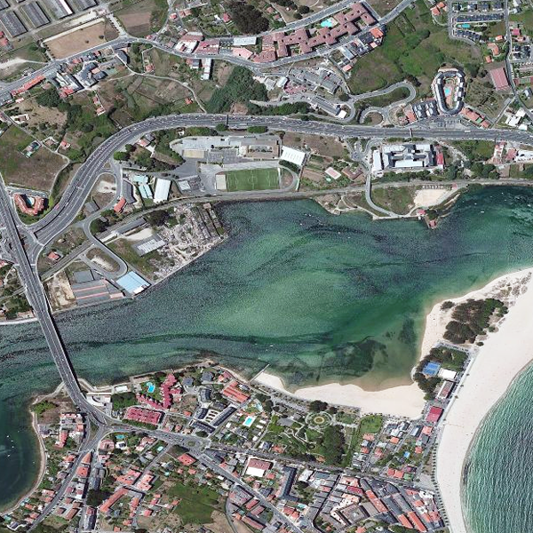
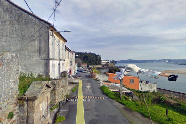
Location A Coruña. Ría del Burgo
Population 245,293 inhab.
Strategic site 42.06 ha - Project sites Area 1: 6.743 sqm / Area 2: 6.863 sqm
Site proposed by A Coruña City Council
Owner(s) of the site Public and private
Commision after competition Inclusion in the team that will coordinate the participatory process to design tools and plans. Possible participation in an afterwards project
Team representative architect
More Information
How can the site contribute to the adaptable city?
The general objectives with respect to the adaptable city are to improve accessibility, resolve interface conflicts, intercon-nect service systems, the integration into the overall territorial structure of traditional rural townships and settlements, com-plete the network of green or pedestrian routes; regenerate gaps caused by the obsolescence or abandonment of land used for certain activities.
The proposed site is sensitive to all these factors and requires treatment.
City strategy
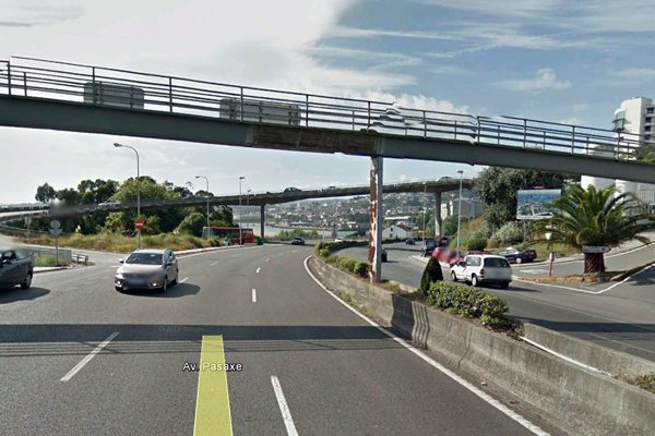
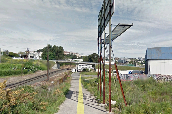
In response to these objectives, in the coming years the envisaged major urban transformations that affect this part of the city, specifi-cally the proposed site, will be: widening the bridge over the Burgo estuary, the entry point of the N-VI national highway; the reuse of the former railway line in As Xubias for a commuter rail system; the extension of the seafront promenade to the Pasaje bridge, comple-ting the municipal system; the interconnection of the general healthcare facilities in and around the area, in Oza, on both sides of the As Xubias road.
Faced with such major transformations, a broad analysis within a public participatory process is required to generate urban planning initiatives and strategies based on existing resources.
Site definition
This estuary frontage, with the powerful or consolidated presence of various urban situa-tions, is bounded to the north by the Oza township and the prominence of large healthcare buildings (hospital, school, psychiatric centre), and to the south by the zone around the "da Pasaxe" bridge, at the start of the Burgo Estuary promenade, part of the adjacent Culleredo municipality.
At various points, this frontage is accessed from the dense da Pasaxe Avenue, a trunk road of vital importance as it provides direct access to the three entry points to the CHUAC, A Coruña's public hospital complex. The territorial split caused by this major artery is offset by the east-facing aspect of all the settlements along this frontage.
Underpinning this estuary frontage, it is important to note the railway line, now used infre-quently, which links the city to the north of the province and also to the connection nodes with the rest of the country's northern regions.
Future of the site in relation to the site family and Adaptability
In this site's study area, an analysis is required of the interconnection of the various parts of the health care facilities -urban and district- located in the area and its environs; the interface between this part of the city (As Xubias) with the sea (Burgo Estuary), seeking to form a connection more than a separation (the nearest point of Santa Cristina Beach lies within the A Coruña municipality); the peaceful coexis-tence of this part of the city with the future commuter railway line, transforming this physical obstacle into a new connection; maintenance and renewal of a traditional township linked to the fishing indus-try, where there are also several manor properties (Pazo do Pasaxe, Casa Grande do Pasaxe); the readaptation of the void resulting from industrial abandonment on the site of the former Celta cannery, near the Pasaje Bridge, whose expansion will take up part of this plot; the opportunity to create and or-ganise another small buildable area between the Maternity Hospital and the estuary.
All images © Google Maps, except Cover © Bing
Questions on the site
Can we develop the urban proposal outside the limits of the marked yellow area? ¿Se puede actuar fuera del área señalada en amarillo?
The project site contains the key elements that are subject of the analysis. The marked yellow area is bordered to the east and west by geographical elements or infrastructures separating the rest of the territory structure (the sea, the As Xubias road) and to the south by the limits of the municipality. We are aware of the existence of some elements and characteristics of the territory that go beyond the project site and that can have an impact on it (reference in this respect has already been made in the memo of the project to the construction to the west, crossing the road, of a large part of health-care facilities). Due to the nature of the call for proposals, we understand that, if duly justified, the urban proposal can be developed outside the limits of the marked yellow area.
El ámbito de la propuesta es el que contiene los elementos fundamentales objeto del análisis. En su delimitación, la línea amarilla se apoya: a Este y Oeste, en elementos geográficos o en infraestructuras que separan del resto del territorio (el mar, la carretera de As Xubias); al Sur, en el límite del término municipal. Somos conscientes de la existencia de elementos y características del territorio que, transcendiendo del ámbito delimitado pueden influir no obstante en el mismo (en ese sentido, ya se ha hecho mención en la Memoria a la implantación al Oeste del ámbito, cruzando la carretera, de gran parte del equipamiento sanitario). Dado el carácter de la convocatoria, entendemos que, de forma justificada, se puede actuar fuera del ámbito señalado en amarillo.
in the project area 2, what kind of programme can we do? ¿Cuál es el programa para el área de proyecto 2?
Free housing, up to 7,000 total building m2 (arcaded diaphanous ground floors are allowed)
Vivienda Libre, hasta un máximo de 7.000 m2 edificables (se permiten plantas bajas diáfanas porticadas).
Has the administration foreseen what to do with the shanty-town dwellers living now in the area of the project site and where to resettle them? Is this an issue we, competitors, could or should raise? ¿Se ha pensado desde la administración, que hacer y donde reubicar a las personas que actualmente viven en las chabolas existentes en el ámbito de actuación? ¿podemos/debemos plantear nosotros esa cuestión?
In this particular project area there is a building not occupied by shanty-town dwellers. They have their settlement nearby. The approach of relocation could transcend the aim of the competition, although it would be interesting to have new ideas.
En esta área concreta de proyecto existe una edificación no ocupada por chabolistas. Éstos tienen su asentamiento en las cercanías. El planteamiento de su reubicación podría trascender del objetivo del concurso, aunque sería interesante contar con nuevas ideas
When it is said that the green corridor must be within the easement area, does it refer to the strip up to 20 meters beyond the sea shore line or from it? ¿cuando se refiere el enunciado a que el corredor verde debe estar dentro de la zona de servidumbre, se refiere a la franja situada hasta 20 metros mas allá de la línea de costa, o a partir de ella?
The easement is the oficial one from the legislation coasts, that means, in this developed land (urban land): 20 meters from the sea shore line.
La servidumbre es la de la ley de costas, es decir, en este suelo urbano: 20 m desde la linea de ribera del mar.
This site is connected to the following theme
How to transform physical obstacles into new connections? We understand “bridges” as linear connections between different contexts spanning over a barrier, which may be a river, a railway track or other physical obstacles. But we sometimes can transform the obstacle so that it allows movement in different senses and directions, becoming a connecting element rather than separating barrier. The obstacle may be inhabited, cut or criss-crossed; it can become an opportunity to increase density, change the functions on either side or bring a new perspective to a familiar context.
Specific documents
Questions on the site
You have to be connected –and therefore registered– to be able to ask a question.
Fr. 16 May 2025
Deadline for submitting questions
Fr. 30 May 2025
Deadline for answers
Before submitting a question, make sure it does not already appear in the FAQ.
Please ask questions on sites in the Sites section.
Please ask questions on rules in the Rules section.
If your question does not receive any answer in 10 days, check the FAQ to make sure the answer does not appear under another label or email the secretariat concerned by the question (national secretariat for the sites, European secretariat for the rules).