Molfetta
The Synthetic Site Folder and Site Brief are available for free.
Please register and login to access the Complete Site Folder.
- Synthetic site folder EN
- Site on Google Maps
- Back to map
Data

Category Urban – architectural
Location Molfetta, Italia
Population c. 60,000 inhab.
Strategic site 35 ha - Project site c. 12 ha
Site proposed by Municipality of Molfetta
Owner(s) of the site Municipality of Molfetta and State
Commision after competition In addition to the public presentation of the projects, the Municipality should consider to start a process, also involving prize-winning teams, through workshops, urban studies etc., aimed at the development of detailed planning
Team representative architect
More Information
How can the site contribute to the adaptable city?
The city is in a phase of reorganization involving urban and socialeconomic aspects. The activities that were supporting the local economy, especially those referred to the sea activities, are now downsized. These changes have urged the Municipality on deciding to qualify one of the most important resources of the city that must adapt to new uses and become an element attracting the inhabitants and the whole territory: the urban waterfront. In this moment of revitalisation, the city overlooking the sea has to take it back and «live in it». The waterfront reorganisation will represent the starting point to enhance the existing building estate and will have to be able to activate a process of transformation representing a chance of development and growth for the entire city.
City strategy
Currently, the Municipality is going on to realize a plan of urban regeneration aimed at reducing the land grabbing and reusing the urban housing heritage by planning a city space designed for the real needs of the inhabitants. A rehabilitation, based on little interventions that can be developed gradually by sharing with the residents and the economic actors, obtained by: upgrading parks and outfitted green areas; improving transport network in the suburban areas; creating bike lanes and a plan of sustainable mobility; planning urban free beaches, in view of the approval of a coasts general plan; regeneration of the coastal areas to support tourism and commercial activities.
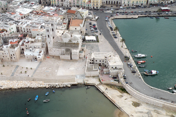
Site definition
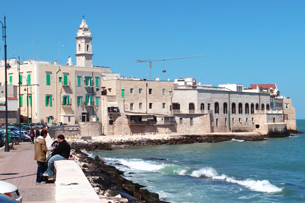
Molfetta is one of the most populated cities in Puglia, after Bari. It has an historical centre of Medieval origins, developed on a small peninsula, and a more modern area. This area is formed by the southbound expansions of the XVII-XVIII centuries and by more recent settlements toward west and east, gradually expanded beyond the railroad. The site consists of the two arms of coast extending to the east and west from the Old Town, each one 1.5 km long. In particular, the western waterfront starts from the Old Town and reaches the Basilica Madonna dei Martiri; the eastern arm goes from the Old Town to the bay called Prima Cala. Although swimming is allowed in the east area, the access to the sea is often hampered by natural and artificial morphological barriers.
Future of the site in relation to the site family and Adaptability
The program of the waterfront regeneration foresees: EAST SIDE: creation of a public beach for swimming with the related services; accessibility to the state maritime bathing area from the above Marcantonio Colonna sea promenade; bike and pedestrian paths connecting the Marcantonio Colonna promenade, with the rear Municipal Villa, to the beach of Prima Cala, where it’s planned also the rehabilitation of the former seaside holiday camp; pathways and functions of catering in some areas. WEST SIDE: planning a continuity of routes between the church of Madonna dei Martiri and the Cathedral; proposing new functions inside the sensitive areas which take into consideration the needs of the inhabitants and the potentiality of the current resources through outfitted areas and services for tourist and cultural aims; reorganising the roads and parking systems to favour the new cycle and pedestrian ways Punctual architectural proposals must be planned in some sensitive areas of both sides. The aim of the whole project should be to revitalise the urban space, so to make it more liveable and to turn it into a chance of settlement for new production and commercial activities, an attractive area for a new way of tourism, as well as a site where also the traditional activities already established there can develop in a more efficient way. The project must be able to combine the need for a new waterfront design with some processes of transformation already in progress.


Questions on the site
I would like to know if the project proposals must relate to both sides, specifically East and West, or we can choose only one part. Gradirei sapere se le proposte progettuali devono riguardare entrambi i lati, nello specifico Levante e Ponente, oppure è possibile la scelta di una parte soltanto.
Proposal must include both fronts.
La proposta deve comprendere i due fronti.
Can architects with a master degree and admitted to practice,yet not listed in any professional order participate as associates? Gli architetti in possesso di una laurea magistrale e abilitati all'esercizio della professione ma non iscritti a nessun ordine possono partecipare come associati?
Please ask your questions on the rules in the section "Questions on rules". Anyway the answer is yes, you can participate.
Grazie per fare domande sul regolamento nella sezzione "Questions on rules". La risposta comunque è si, possono partecipare.
I would like to know if there is any drawing or architectural information about the Colonia building in Levante waterfront and "capannoni demaniali" in Ponente waterfront.
Unfortunately no detailed plans have been found on the two buildings (Colonia and shipyards). However, for the building of the Colonia it can be considered its shape from the floor plans provided, taking into account that inside is empty. As regards the shipyards, even if the area is included in the project area, has been clarified in the report that the proposition must not provide an accurate restoration project of the sheds, but an idea of how can be solved the connection beetwen western-centre through indications of paths, uses, functions. So, for that it is sufficient the cartography already provided.
A.Could the empty space to the South of Secca de Pali, included in PIRP but outside of the western project site, to include interventions? B.If not, is it to be considered as the boundary fence of this space? C.For example redeveloping the small buildings on the north, overlooking the Viale dei Crociati
A. It can not include interventions. B. must be considered as a limit. C. Question unclear
May the project include interventions in via Dante?
Generally in the study area the competitors can do proposals that are functional to their idea, but these are not considered in the judgment neither positive nor negative
May the project include interventions in the sequestered commercial port?
Absolutely no.
Could we think to relocate the area of the shipyard?
The relocation of the shipyards is a very sensitive issue that could not be resolved in the short term. therefore it is better not to base your project on relocation of the shipyards, but rather to find solutions for a coexistence of different functions.
The connection between the San Domenico dock and Viale dei Crociati can it also be vehicle accessible or can it be pedestrian only?
Pedestrian only
Is the Cala dei Pali a beach where swimming can be expected?
NO swimming, water sports and similar YES
- Are the existing projects to be implemented (file provided after the site visit) maintained or could we modify them?
- What foreseen the area of the eastern waterfront destined to “standards urbanistici”? Has the Municipality already a project, or quantity of areas for pubblic parc, parking lots, etc.?
- PIRP and Detailed Plan close to the sports area overlap the project area: should be considered as constraints or could they be modified?
The areas for urban standards on the eastern waterfront are those provided by the Master Plan of the "Comparto B2" whose documentation is available to competitors. The area of the "comparto B2" (the strip in front the coast) may be subject to additional proposal.
On this theme we’ve already given explication in the site visit report. The existing executive plans must be maintained. This Plan which is being approved may be subject of proposals in the part related to the coastal strip.
The introduction of new features to “Secca dei Pali” is a free choice of the project or there are special needs to be met?
Free choice of the competitor
- Can we receive more information on pedestrian areas and those where instead vehicular traffic has to be mantained?
- Can we have more informations on the need for parking areas and in which areas are no longer necessary ?
- Can we get information relevant to vehicular traffic and the current direction of movement on the waterfront?
The development of the Urban Plan of Sustainable Mobility - PUMS - is still going on, so, at present, it has not taken any decision on the future pedestrian zones, on the main lines of vehicle or about public parking areas.
Competitors may, however, submit proposals for any pedestrianization or destination in parking areas according to their own project solutions. The interesting proposals will be evaluated in the PUMS.
What is the tour of Maddona's sculpture for the traditional celebration? where are the two points where it's taken on board and landed (ex. banchina San Domenico)? Is it possible get the tour traced on a plan or a map?
The tour of Madonna dei Martiri provides boarding at the Molo Pennello and disembarking on the dock San Domenico with a free route inside the port. So it's not necessary trace it in a map.
- Quay San Michele, San Corrado and Pennello can be redesigned or are considered outside of the competition? The same for dock called "autorimessa" ?
- Can be further explained the present and future functions in the dock called "autorimessa" and in the largest one in construction?
The current docks of the historical port are out of competition and therefore can not be planned.
Autorimessa means a boatshouse. The activity has expanded also in shipbuilding. The granting, however, is renewed in the short term, so it’s possible to submit proposals in this portion of Secca dei Pali
Is the large parking area (south of the PIP, via bisceglie) for public use?
Yes, it is for public use
How we relate to the area of museum development at the old town? There is no additional information?
The museum has been included in the report to indicate the existing cultural facilities (museum of San Domenico, Pinacoteca, Giovine Palace, Diocesan Museum), subject to tourism, cultural and accommodation potentiality in Molfetta.
Is the PIRP of Madonna dei Martiri to be included as it is or could we think to an integrations with the Europan project?
Perhaps integrations, but not modifications
Is there a street market in Molfetta? Can we suggest a dedicated area?
Question is not clear. If you refer to street vendors, you can even propose suggestions. If you refer to the commercial axis, this function is performed by Corso Umberto, where there are stores for shopping.
This site is connected to the following theme
How to use new inputs to change urban space? How to profit from new inputs to transform urban space and disperse the incoming positive dynamics to adjacent areas to create new urbanities? How to manage potential tensions between the local and translocal activities? These inputs are related either to new public transport network connections or to new programmatic developments. The scale of these incoming urban dynamics varies from the urban agglomeration to the whole world.
Specific documents
Questions on the site
You have to be connected –and therefore registered– to be able to ask a question.
Fr. 16 May 2025
Deadline for submitting questions
Fr. 30 May 2025
Deadline for answers
Before submitting a question, make sure it does not already appear in the FAQ.
Please ask questions on sites in the Sites section.
Please ask questions on rules in the Rules section.
If your question does not receive any answer in 10 days, check the FAQ to make sure the answer does not appear under another label or email the secretariat concerned by the question (national secretariat for the sites, European secretariat for the rules).