Os
The Synthetic Site Folder and Site Brief are available for free.
Please register and login to access the Complete Site Folder.
- Synthetic site folder EN
- Site on Google Maps
- Back to map
Data
Category Urban - architectural
Location Osøyro, Os, Norway
Population 19,000 inhab.
Strategic site 90 ha - Project site 4.5 ha
Site proposed by Os municipality (in collaboration with Hordaland county)
Owner(s) of the site Os municipality and ESSO Norge
Commision after competition Planning and building commission
Team representative architect - urban planner - landscape architect
More Information
How can the site contribute to the adaptable city?
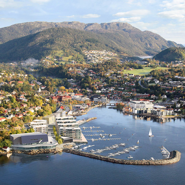
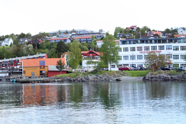
The municipality of Os, located south of Bergen on the west coast of Norway, is facing a doubling of its population within 2040. The municipal centre Osøyro is thought to absorb much of this growth. The site proposed for the Europan 13 competition is the last remaining undeveloped strip of land with access to the centre’s harbour basin. The site is dubbed “the jewel” of down town development. How can Os develop an urban texture that is unique and characterizing of Os? The Europan study area covers a series of other development areas. The competition can therefore contribute to a discussion of the big picture of Os as it transforms from a village to a small town.
City strategy
The Bergen region is expected to grow from today’s 500,000 to 650,000 in 2030. Os is part of this picture of regional growth. Two possible game changers will further enhance Os role in the region. Firstly, the ferry free connection being planned at the Norwegian west coast, connecting Stavanger to Trondheim, would put Os closer to the maritime cluster in Haugesund and the oil capital Stavanger. Secondly, a four-lane highway being built to Bergen makes it more attractive to live in Os for commuters. Os is already taking active measures to prepare for this future. The municipality has made a study plan for Osøyro. The plan’s main component is a shopping based east-west axis and north-south axis leading from the centre to the Europan site. The municipality has actively engaged itself in the development, investing in property and coordinating efforts to increase and improve urban life.
Site definition
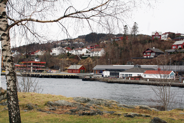
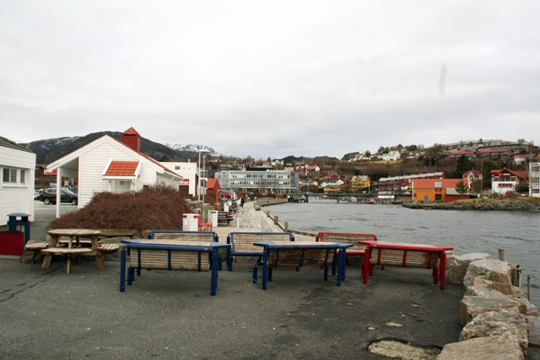
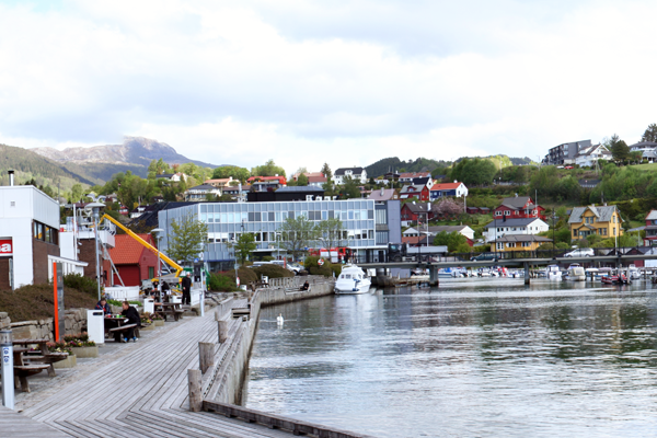
The site today is dominated by grey paving, parking and a gas station. Two county roads and a round-about, splits the site from the urban centre. South side of the site is the harbour for a fjord speed vessel, transporting people to the work region around the Bjørnafjord. The northern part of the quay functions today as a guest harbour for smaller boats and gas fuelling. Here you also find some service functions – a car repair shop and a pizza place. Located west on site, is the old train station, which is an important cultural heritage building, and likewise, across the river mound a workshop producing traditional wooden boats. The municipality wishes for the participants of Europan to investigate widely the future opportunities for the site, focusing on public space, dwellings and commercial space.
Future of the site in relation to the site family and to Adaptability
How can the municipality secure access to the site for all inhabitants of and visitors to Os? The proximity to the centre can allow for a more mixed program, perhaps introducing functions that can be shared both by local dwellers, the public and guests. The old railroad building has potential for new public program, but also new buildings on site can have a public profile. The municipality wish for the participating architects to come up with new ideas for landscape, architecture and urban design, proposing new urban functions that would connect the existing centre with the waterfront development.
Questions on the site
What is the hight difference between the elevation lines on the plans you gave us?
The height difference of the elevation lines is 1 meter for the files named: OS-NO-SS-M1.dxf, OS-NO-PS-M1.pdf, OS-NO-PS-M2-1.pdf and OS-NO-PS-M2-2.pdf
Is it allowed to modify the shape of the harbour, the quay and the dock for speed ferries? Are there any elements in that area that must necessarily be kept unchanged?
The participants are allowed to modify the shape of the harbor, quay and dock for speed ferries, but the quay functions must remain. It is important that the quays can continue to serve as docking for the speed ferry, smaller industrial vessels and as a guest harbor. If modifying the quays, one should consider the impact of the sea, as the docks today are very exposed to heavy waves, and the stream from the river. It is important that the river run free, as it during rainfall carries quite heavy water.
How deep is the water in the deep part for the speed ferry and what is the average depth of the river in the strategic area?
A map with this information, named OS-NO-PS-M1-1.pdf, is available in the folder 0-New_docs_after_launch.
What is the approximate size (plan and volume) of the elements to be kept in the red building containing the sewage pumping function? Could these elements be relocated within the site?
The red building of the sewage pump is of low value, but the function must remain on the spot. Ground floor is approx. 60m2. It is to be expanded within the next couple of years, and it will then be needed approx. 90m2. The pump house requires a cellar and approx. 2,5 meters above ground. If the pump is considered incorporated in new structures, it should be mentioned that the sewage pump includes some problematics concerning smell.
How much is the sea level difference amplitude?
Average amplitude is about +-50 cm. At extreme tide (when the river is flooded due to heavy rain, and strong winds blowing the sea into the basin), it can be up to 1,4 meters above average. See graphics named OS-NO-SS-M2.pdf in folder "0-New_docs_after_launch" and the following link for statistics and more information.
What is the minimum height of the pedestrian bridge?
Smaller boats should be able to go under the bridge. This requires a minimum height of 3 meters above average sea level.
Are there more information about the developments in planning? Especially the one next to the Shopping Centre and the other south-west of the site.
Project drawings for the two requested projects, named OS-NO-SS-M3.pdf and OS-NO-SS-M4.pdf are available in the folder 0-New_docs_after_launch.
Is it possible to have to have a .dwg version of the site? It would be really useful, to be able to measure the distance places, and have a profound knowledge about the site, green areas , height plot building etc.
A file called OS-NO-SS-M1.dwg containing all the requested information is available in the folder 0-New_docs_after_launch.
Is there some specific brief about the competition site with its GOALS AND VISION OF THE FUTURE OS?
The competition brief gives competitors the necessary input on these topics. Bear in mind, you as competitor is asked to contribute to the vision of Os.
This site is connected to the following theme
How to transform physical obstacles into new connections? We understand “bridges” as linear connections between different contexts spanning over a barrier, which may be a river, a railway track or other physical obstacles. But we sometimes can transform the obstacle so that it allows movement in different senses and directions, becoming a connecting element rather than separating barrier. The obstacle may be inhabited, cut or criss-crossed; it can become an opportunity to increase density, change the functions on either side or bring a new perspective to a familiar context.
Questions on the site
You have to be connected –and therefore registered– to be able to ask a question.
Fr. 16 May 2025
Deadline for submitting questions
Fr. 30 May 2025
Deadline for answers
Before submitting a question, make sure it does not already appear in the FAQ.
Please ask questions on sites in the Sites section.
Please ask questions on rules in the Rules section.
If your question does not receive any answer in 10 days, check the FAQ to make sure the answer does not appear under another label or email the secretariat concerned by the question (national secretariat for the sites, European secretariat for the rules).