Guebwiller (FR)
The Synthetic Site Folder and Site Brief are available for free.
Please register and login to access the Complete Site Folder.
- Synthetic site folder EN | FR
- Site Brief EN | FR
- Site on Google Maps
- Back to map
Data
Project Scales L/S - Urban and architectural
Location Department Haut-Rhin, Community of Communes of the Region of Guebwiller, City of Guebwiller, the Florival Valley
Population Community of communes: 40.000 inhab.; City: 12.000 inhab.
Strategic site 47 ha
Project site 6.6 ha
Site proposed by City of Guebwiller and NSC Florival
Actors involved City of Guebwiller, NSC Florival, Établissement Public Foncier Alsace / Massif des Vosges
Owner of the site City of Guebwiller and NSC Florival
Post-competition phase urban study and masterplan for strategic site, project development for public spaces, architectural feasibility study and implementation
Team representative architect, uban planner, lanscaper
More Information
How can the site contribute to the productive city?
The Northwestern part of Guebwiller is mainly occupied by old textile industries that significantly contributed to the economic development and attractiveness of the city during the 19th and 20th centuries. Today, the textile activity has been highly reduced. However, rope manufacture has been maintained and a part of the site has been reconverted into textile machinery manufacturing intended for export. In partnership with NSC Florival, the city is willing to undertake a progressive transformation of this site, located in the heart of the city. They are also eager to initiate a balanced requalification of the territory by implementing various urban functions, including productive activity in order to provide new answers for purposes of employment and life quality.
City strategy
On the territorial scale, Guebwiller is considered as a main urban pole. The city gathers the main equipments and is expected to strengthen, together with the cities of Soultz, Buhl and Issenheim.
As Guebwiller is located at the entrance of the valley, the city can no longer be extended. Thus, this constraint should be changed into an asset and encourage the city to consider its development by involving its own industrial wastelands in partnership with private actors. The city is eager to encourage new economic activities and to reinvigorate the city centre in order to generate a transformation dynamic and to improve living conditions, including a better air quality thanks to energy-saving constructions.
Site definition
The city of Guebwiller is located at the entrance of the Florival Valley, on the wine route, along the Lauch River, on the north-facing side of the Rehbrunnenkopf mountain (∆ 632 m) and the left bank of the Lauch River, on the sunny slope of the Oberlinger mountain (∆ 586 m) partly occupied by a renowned vineyard that has four “Grands Crus”.
The strategic site covers the wastelands area, the connection with the historical centre, the primer hillsides and also the adjoining urban developments. Situated next to the city centre, it extends over a 47 ha area, on the edge of the municipal territory. In the 19th century, the industrial companies settled next to the Lauch River and the main roads.
A first project site includes an urban cluster mainly occupied by the “Louvre” building, a reinforced concrete 1.000 sqm building from 1920 which has wide floors and large glazed surfaces. The rest of the cluster is occupied by small city buildings which were formerly intended to workers. A second project site is made of various industrial buildings, presenting a remarkable architecture with sandstone facades connected by shed roofs from various eras, creating a covered floor surface of over 18.000 sqm.
How is Production Considered in the Urban Diversity Program?
The city of Guebwiller wants to pursue a strategic reflection on the future of these industrial brown fields, formerly located in its periphery and now integrated in the urban tissue. What project process can be implemented to reactivate production in the city? NCS Florival has been demonstrating that keeping their activity in the city was possible. Thus, they participate to the urbanity of this emerging part of the city. Meyer SansBoeuf, a cordage company, which is also included in the study perimeter, has maintained its activity.
On the other hand, since 2015, there are several ongoing projects located on the edge of the wastelands, such as the construction of “Gendarmerie” barracks supported by the city but also private housing and services projects.
What activities could find a way back in town? How can this part of the city be redesigned and connected with the existing city? How can inhabitants get involved? The city of Guebwiller can no longer be extended because of the conurbation. How can the wastelands be regained by introducing activities and this way, enable the city to create a new district? The city of Guebwiller and NSC Florival are expecting from Europan a prospective vision that would use the assets of the city to make it productive (again). This raises the question of the activities coexistence and their connections with the different components of the city such as housing, shops, offices, equipments and public spaces.
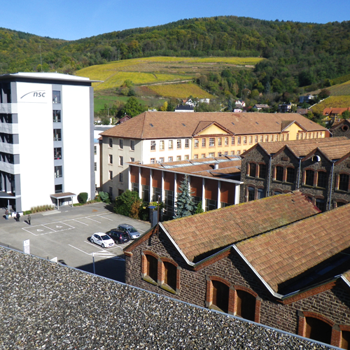
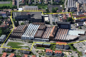 Aerial view of the project site
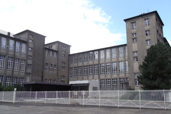 The Louvre building
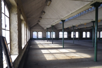 Interior of building 39, plot NSC
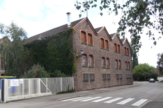 Building 28, plot NSC from rue de la République
Questions on the site
Would it be possible to get the PDF plans PS1 & PS2 in DWG or DXF format? At least both PS2 plans have been drawn in CAD whilst the developer of the Louvre might already have a survey in CAD format too. Thanks.
There is no DWG for the project site: the plans for the Louvre are the property of the developer and the owner of the site, the NSC florival compagny, has no DWG documents for the other building
We'd urgently require an English version of the PDF file called FR-GUEBWILLER-T-annexe Thanks.
You can download the English version of this documents in the complete site folders, in the folder "0-New_Docs_after_Launch".
Where does the municipality get the flowers and plants for the city ? Is there an ongoing public market with a green spaces maintenance organisation ? As far as we know, there is no municipal greenhouses in Guebwiller.
Annual and biennal plants supply : micro root balls supplier in Colmar Bush and trees supply : the supplier is in Rouffach Mulching supply : local suppliers Green spaces maintenance : municipal offcials (public management) Municipal greenhouses: 1800sqm: for micro root balls plants : greenhouse growing before planting.
Regarding topography, could we get any document explaining how ground level changes along the site? Are the buildings connected by a single ground floor? And is the ground floor at the same height in every building? Is there a difference in height between the inside of the buildings and the street?
Buildings are connected by a unique flat ground floor. But it is a slight sloping ground. Regargins the 5-11 sheds, the building is 1m submerged. There is an access ramp and on the other side of the 34 building, there is a 1m raised floor from Wekerlin street.
Could you tell us what the clear height is for Building 5-20 ? Do buildings 5-39, 5-35 ans 5-11k have the same type of truss?? Is there any information about the basements, such as pictures or plans, that explain how their structure is?
The B20 building has a 12m gutter height and a 13,5m ridge height. The 5-39 building is from 1960. Gutter height : 4,5m and ridge height : 7,5m The 5-35 building is from 1960. Gutter height : 4m and ridge height : 7m The 5-11 building is from 1950 See document "Questions_aux_candidats" that was added in the 0_New_docs_after_launch" in the downloadable documents list.
In page 27 of the “4-BRIEF-T-En”, it says “The town lacks a multipurpose room of 1000m2 (not in the annexes)”, what do you mean with “not in the annexes”? Should we not consider it in our proposals?
You can consider about 800m² of annexes such as boiler room, sanitary, storage rooms, offices.
Is there any way to find CAD plans of the adjacent cities, such as Buhl, Lautenbach, or Soultz-Haut-Rhin?
No
Regarding dwelling design, what is the applicable regulation for dwelling in Guebwiller?
There is no specific regulation except the compliance of construction code
During the site visit, the Mayor said the city pre-empted various industrial villas. Could you be more precise regarding this municipal heritage and especially the villas addresses ?
In the strategic sector, the municipality recently pre-empted the Bois Fleuri
During the site visit, Mr Ameline said the NSC company owned various brownfields. Could you be more precise regarding these properties and especially the parcels numbers ?
The project perimeter is mainly constituted by NSC brownfields.
As the local urbanism plan is being approved, to what extent should we consider this LUP ? When will it be finally approved ?
You can find online the Local Urbanism Plan on the city's website. It will be approved in November 2017.
In the LUP zoning plan of May, 18th 2017, you can see that the site is integrated in the UBb, UBI and 1AUc zones + a development and programming orientation. What regulation should we take into account ?
The regulation of the development and programming orientation
Can we consider the site be considered as one and only property or should we take into accound separative limits ?
The site can be considered as one property.
In which area is the tram station going to be located? Are there more information about its possible implementation in the small residential buildings area ?
In a zone located down the 17 Novembre street and Malgré-Nous street.
If there's a flood risk in the site, can we facilitate the flood-prevention plan ?
Refer to the flood-prevention plan attached to the Local Urbanism Plan
This site is connected to the following theme
And productive again! How to Reintroduce the Productive Economy into New Urban Districts? Many formerly industrial places in and around cities are now out of use. Buildings were left in a derelict state, activities have been moved or stopped, sites became brownfields. Obsolescence is the common feature of these sites and the future is uncertain. Mostly, we dream of turning them into new vibrant urban quarters. But to avoid total gentrification as it has appeared many urban renewal projects in the past, we should perhaps try to put some productive activity in these sites… again? Because these sites were once industrial and linked to the city. Because there is a will for a really mixed city, and that mix includes productive economy as well.
How to Reintroduce the Productive Economy into New Urban Districts?
Specific documents
Vidéo réalisée lors de la visite du site de Guebwiller, le 13 avril 2017, en présence de : Monsieur Kleitz, Maire, conseiller régional Monsieur Ameline, Président Directeur Général de la société NSC Monsieur Muller, conseiller à l’urbanisme et grand projet Madame Le Moing, EPF Alsace Monsieur Beydon : Société Schlumberger Sandrine Michel : chargé d’opération Grand Projet, en charge du dossier EUROPAN, Hugues Levi-Topal, Directeur Général des services Sandra Gérard, directrice de la communication
Questions on the site
You have to be connected –and therefore registered– to be able to ask a question.
Fr. 16 May 2025
Deadline for submitting questions
Fr. 30 May 2025
Deadline for answers
Before submitting a question, make sure it does not already appear in the FAQ.
Please ask questions on sites in the Sites section.
Please ask questions on rules in the Rules section.
If your question does not receive any answer in 10 days, check the FAQ to make sure the answer does not appear under another label or email the secretariat concerned by the question (national secretariat for the sites, European secretariat for the rules).