Ås
Les Dossiers synthétiques et d'enjeux sont disponibles gratuitement.
Merci de vous inscrire et vous connecter pour accéder au Dossier complet de site.
- Dossier synthétique EN
- Le site sur Google Maps
- Retour à la carte
Données synthétiques
Category Urban - architectural
Team representative architect - urban planner – landscaper
Location Ås, Ås municipality
Population 18,000 (municipality), 1 on site
Strategic site 1.4 ha
Site proposed by Ås municipality
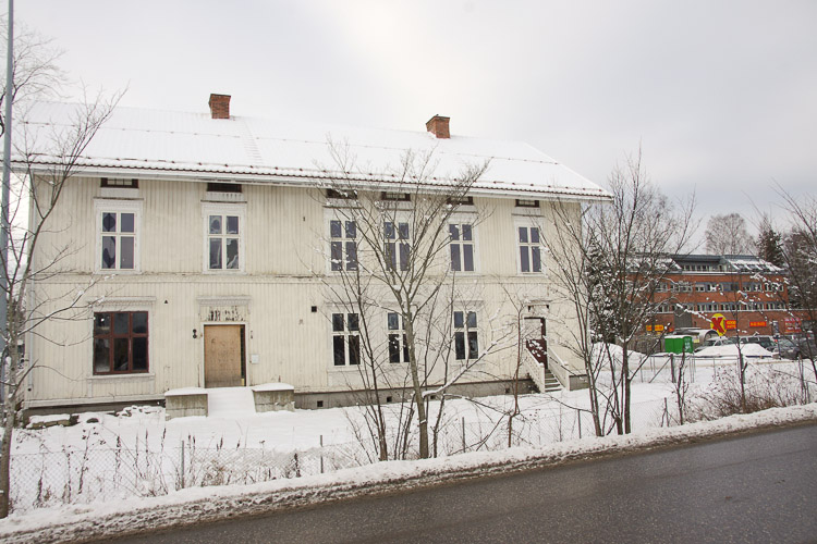
Owner(s) of the site Odd Tandberg, Anne Lene Skotterud, Ørjan Eriksen
Commission after competition Building commission
Information complémentaire
How can the site contribute to the adaptable city?
Ås is a municipality on the outskirts of the capital region of Oslo, and is now seeing clear signs of a capital with expansive growth that lacks space for both housing and industry, with the result of increased pressure on its surrounding areas. Among the municipalities in the region, the forecasted population growth in Ås is among the highest, with a doubling from approximately 18 000 inhabitants in 2013 to approximately 32 000 inhabitants in 2040. Ås’s growth in population and the town’s adaptation to this creates two main challenges; on one hand meeting the regional housing demand, and at the same time seeing how this adapts to Ås’ local conditions. Ås is the largest agricultural municipality of Akershus and home to the Norwegian University of Life Sciences. An overarching objective for the competition is to better connect the university life with the urban life of Ås centre.
City strategy
Politicians, planners, developers and the university have joined forces in the Europan competition to see how they can utilize a central plot to take Ås further. How can this site represent something different and unique, compared to what has emerged so far? How can the site act as an example to follow for the future, where the demand of dense development is balanced with urban spaces of high quality? How can the site contribute to strengthening the connection with its surroundings and trigger the creation of a territorial network? How can the site contribute to a more advanced co-existence between Ås and the university? The municipality wants to view the development of the site through four lenses; the growth city (the ability to absorb growth), the university town (to strengthen the relationship between municipality and university), the edge city (where the rural and urban meets) and finally through the culture town (using cultural program as a tool for development).
Site definition
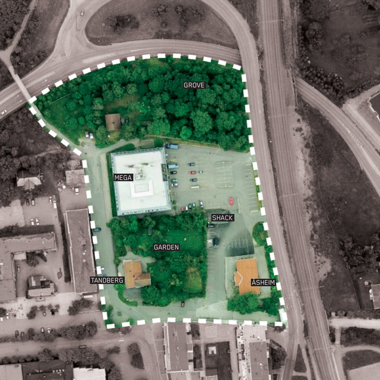
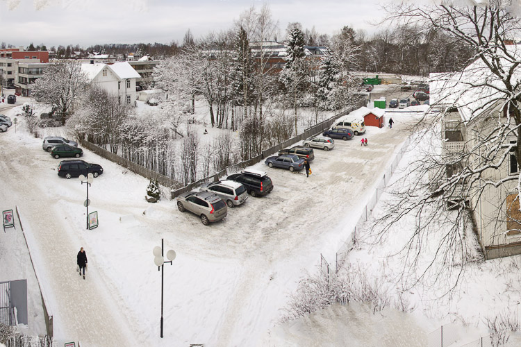
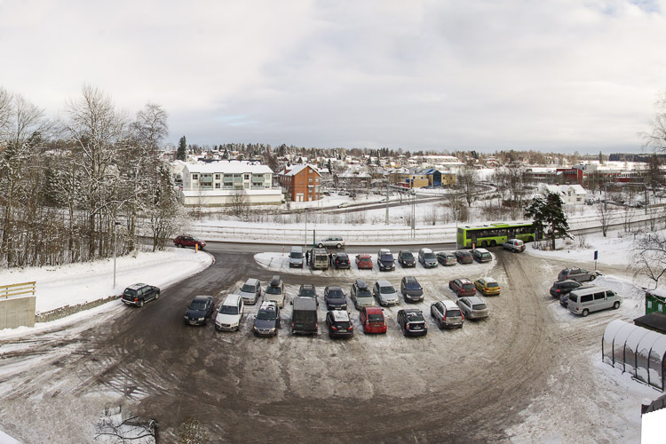
The site is located in the centre of Ås. It‘s proximity to both the station and the campus makes the site an interesting link between Ås and the future development of the Oslo Region. Today the site’s program is mixed; commercial, housing and parking. The site is located in the corner of the L-shaped street that today functions as the main shopping street of Ås.
Adaptability: main challenges to take into account
With strong national and regional constraints to localize population growth to centers around train stations in order to strengthen public transport, the village of Ås is standing on the cusp of great change. The small and sleepy village faces a turning point of challenges and possibilities. The Europan competition in Ås calls for a strategic programming of a central site, showing how a block in Ås centre can function as an urban arena including a new institution for Ås’ most famous artist, student housing, public space and the introduction of university life into the town centre.
Questions à propos du site
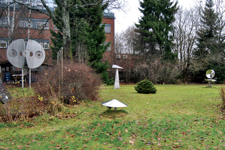
The program is kind of confusing when it comes to preservation of the two wooden buildings in the south of the site (Åsheim and Tandberg). Are any of them certain to be kept?
Only Åsheim is certain to be kept. The program invites participants to consider keeping other buildings and adapting them to new use. The benefits of either tearing down or preserving buildings should be made clear in the presentation.
Is there a translation available for the legend of the map "AS-NO-C-M1-4"?
Sadly not, but the essence is this:
Variations of green show forrest.
Yellow, orange show farmlands.
Purple shows urban areas.
Can you provide more information (maps / pictures) where functional use of Moerveien, Brekkeveien and Raveien become clear?
More pictures have been uploaded. Moerveien is the main shopping street in Ås, Raveien is a side street with some shopping and Brekkeveien is primarely a road for car traffic through the centre of Ås.
Can you provide more information on the ongoing development south of the project site? Specifically functional use.
The areas or blocs south of the site are dominated by shopping on ground floor, some office buildings and high density of housing.
Is it possible to provide the actual GSI and FSI of the study area?
Here is the BRA and FSI for the neighbouring blocks of the Europan site:
Sentrum Nord #1 (housing), 2013
BRA = 2950 m², BYA = 737 m² - FSI = 2, GSI = 0,5
Kiwibygget (housing, commercial), 2008
BRA = 15395 m², BYA = 3000 m² - FSI = 2, GSI = 0,4
Hotellkvartalet (housing, commercial), 2014
BRA = 8000 m², BYA = 1700 m² - FSI = 2.16, GSI = 0,46
Nylundkvartalet (housing, commercial), 2013
BRA = 9353 m², BYA = 1200 m² - FSI = 3.87, GSI = 0,5
Posten (offices), 1964
BRA 2130 m², BYA = 710 m² - FSI = 0.65, GSI = 0.22
Mattilsynet (offices), 1964
BRA = 3200 m², BYA = 1065 m² - FSI = 0.9, GSI = 0.3
Boligkvartal #1 (Moerveien 14) (housing), 2010
BRA 3500 m², BYA = 1100 m² - FSI = 1.45, GSI = 0.45
Boligkvartal #2 (Moerveien 16) (housing), 2006
BRA = 4600 m², BYA = 880 m² - FSI = 2, GSI = 0,4
Close proximity single-family housing areas in southwest (Sagaveien) and northwest (Kaja) within the study area:
GSI = 0.25, two-story houses or GSI = 0.3, one-story houses
Would you please clarify the program needed on the project site and the study site?
Please see page 20 in the program.
Are the areas "ongoing development" on the West and South of the project site to be developed by the competitors?
No. Competitors are only asked to make a proposal for the project site and the study site as described in the program on page 20.
Are the 4 or 5 buildings right on the south of the project site certain to be kept?
Unclear what buildings you are referring to. Buildings south of the project site will remain. Of the buildings on site we refer to the program:
"Participants must take into consideration the preservation of
existing buildings. Only the Åsheim building is certain to be
kept, but participants are asked to examine the potential of
keeping other buildings. Åsheim’s fi rst fl oor is kept for housing,
but the ground fl oor and the surrounding garden should be
integrated in the new concept for the larger site."
What will be the density of the ongoing development?
Competitors are asked to speculate about the density on site. We refer to previous question and answer about density on neighbouring sites.
In case of winning the competition, what kind of work would do the winning team?
The winning team will be invited to negotiate a contract with the site owners for the design of the Europan site. All the different land owners of the site wants development within a short time period and are ready for realizing building projects soon after the Europan competition has finished.
What's the meaning of BRA, FSI and BYA?
BRA: Floor area
BYA: Built area (the building footprint)
FSI = Floor Space Index
What's the meaning of GSI?
GSI = Ground Space Index
Can you provide more information on the ongoing development west of the project site?
We have uploaded a map showing the regulation of the site west of the project site in the competition folder.
Also there is an illustration showing the plans called ÅS-NO-PS-M4-2.pdf already in the folder showing how the neighbouring site will look.
It exists a zoning plan for the areas south of the site dating from 2002. It is the municipality's wish not to show this because major parts of it has not been implemented and they feel it will confuse the participants to show it.
Is it possible to provide plans of the ongoing development south and west?
We have uploaded a map showing the regulation of the site west of the project site in the competition folder.
Also there is an illustration showing the plans called ÅS-NO-PS-M4-2.pdf already in the folder showing how the neighbouring site will look.
It exists a zoning plan for the areas south of the site dating from 2002. It is the municipality's wish not to show this because major parts of it has not been implemented and they feel it will confuse the participants to show it.
What are the approximate ages of the three wooden buildings on the site and do they have any heritage value?
See page 17 in program for answer.
Mention is made in the brief to a new master plan which will be adopted during 2015. Can any information on the likely form of the master plan be made available?
Little effort has been made so far in developing schemes for the new master plan. It is apparent however, that a central part of the discussion will concern which areas of centrally located land will be included for future development.
The most controversial and difficult political discussions will most likely concern whether the northern part of agricultural lands east of the railway tracks (Dyster), and to what extent parts of western agricultural lands (Sørås), will be made available for development. As well as potential development in the northern ridge stretching towards the university.
That being said, work produced in the Europan competition has great potential to inform the master plan process which is set to start this fall.
Can you provide the file AS-NO-SS-M1 and AS-NO-PS-M1 with the excisting buildings as complete 3D-objects?
Sadly no 3D-models of any of the buildings are available.
Can you provide specific parking standards in relation to the requested site program?
See Site Visit Report for answer.
Can you tell us the height of the railway track in relation to the site?
The railway tracks are at the same height as site ground level. (C +95)
Is there a regulation about height limit on the area?
See Site visit report for answer.
What is the age of the wooden house to the north of the Mega building and does it have any heritage value?
The wooden house to the north is about the same age as the other wooden buildings on site. It holds no apparent heritage value and will not likely be preserved.
Is it possible to build anywhere on the project site including the grove?
Yes, with exception of the Åsheim wooden building to the south east, which will remain. However, the outdoor space and programming of the ground floor can be discussed. Other than that the entire area is free to dispose as participants see fit, including the grove.There is a construction limit towards the northern county road (20 meters from center of the road) and the railway tracks (30 meters from the center of tracks) as per governmental regulations. Although reasonable dispensations from these rules may be allowed, there is no guarantee.
Can you please clarify if the 30m set-off from the railway tracks relates to the centre of the tracks, the nearest edge of the tracks, the boundary fence or some other point?
It relates to the center of the tracks.
Is it possible to get the drawings in dwg format that includes layers?
Sadly no layered dwgs are available. There is an interactive GIS-service at http://www.follokart.no (currently being updated) which may help referencing various layers, however it is strictly in Norwegian.
Is Asheim torn down and should it be reconstructed as it says page 17? In this case can it be displaced inside the site? Or does it have to be located in the same exact place where it was located
It should have the same location.
Le site est lié au thème suivant
Territoires en réseau Il s’agit de sites qui, en raison de leur lien avec une entité plus grande, développent leurs potentialités urbaines. Cette entité peut être physiquement concrète, comme une infrastructure de transport, ou peut être un réseau virtuel de relations entre plusieurs nœuds urbains. Bien que les communautés qui habitent ou utilisent ces sites puissent être petites et apparemment isolées, la connexion avec le réseau leur ouvre des possibilités d’amélioration de leur vie urbaine par un nouveau mélange de différents programmes et une urbanité plus complexe.
Comment peut-on préparer ces territoires à résister aux différents scénarios qui pourraient affecter les autres éléments du réseau ou le réseau lui-même ? Devraient-ils être organisés de façon à ce qu’ils puissent adopter différents rôles au sein du réseau ? Comment peuvent-ils s'adapter à la possibilité de changements importants du réseau, voire à sa disparition, par la définition de leurs propres caractéristiques urbaines et architecturales ?
Questions à propos du site
Pour pouvoir poser une question, vous devez être connecté (et, par conséquent, inscrit au concours).
Ve. 16 mai 2025
Date limite de soumission des questions
Ve. 30 mai 2025
Date limite de réponses aux questions
Avant de soumettre votre question, assurez-vous qu'elle n'apparaît pas déjà dans la FAQ.
Merci de poser vos questions sur les sites dans le menu Sites.
Merci de poser vos questions sur le règlement dans le menu Règlement.
Si votre question ne reçoit pas de réponse dans les 10 jours, merci de vérifier qu'elle ne figure pas dans la FAQ sous un autre intitulé ; sinon, contactez le secrétariat concerné par email (secrétariats nationaux pour les sites, secrétariat européen pour le règlement.)