Budapest
Les Dossiers synthétiques et d'enjeux sont disponibles gratuitement.
Merci de vous inscrire et vous connecter pour accéder au Dossier complet de site.
- Dossier synthétique EN | HU
- Le site sur Google Maps
- Retour à la carte
Données synthétiques
Category urban - architectural
Team representative architect - urban planner - landscaper
Location Budapest - Zugló
Population District 123,000 inhab. - City 1,730,000 inhab.
Strategic site 420 ha - Site of project 23 ha
Site proposed by Municipality of the 14th district of Budapest
Owner(s) of the site municipality, private owners
Commission after competition Design of public space interventions; strategy for the development of the public space zone; local masterplan
Information complémentaire
How can the site contribute to the adaptable city?
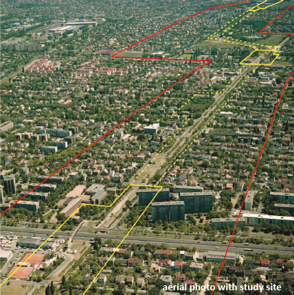
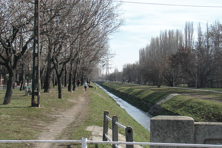
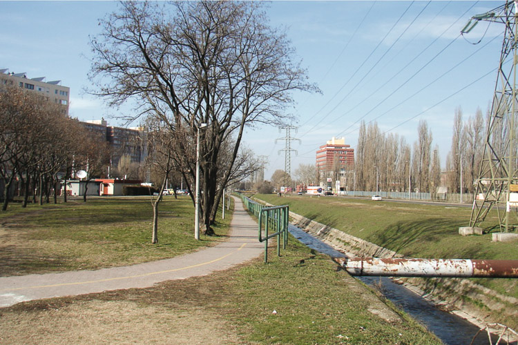
The site is located along Rákos-patak (creek) that had played a vital role in the development of the urban agglomeration within the Budapest region. In the mid 20th century the water-course had been regulated and its role in the urban tissue had slowly degraded into its current state. The creek became a hydrological infrastructure that creates an obstacle the city tries to overcome ever since. The result of this conflict is an ambiguous, fragmented urban fabric around the creek, with various residential areas and slowly transforming brownfield industrial zones. Today a new strategy is needed to (re)activate the Rákos-creek and its vicinity and to reintroduce its former ecological, cultural and social values. The site provides the possibility for developing a model for a new urban infrastructure that is able to initiate, connect and transform future developments and can be applied on other locations in the city as well.
City strategy
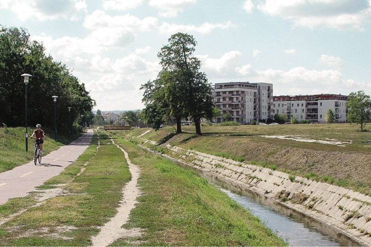
The city district of Zugló, together with six other municipalities along the creek, is investigating the potential for the rehabilitation of the creek. The aim of the project is to establish an ecologic green strip along the water that connects touristic destinations, public functions and able to act as a recreational / eco-touristic corridor which revitalizes the urban fabric.
The goal of the local government, beyond the cooperation of the municipalities, is to develop a strategy for the complex renewal of the urban fabric around the creek, within the borders of Zugló. The aim is to develop the creek’s side through contained, local interventions within a short timescale, but with a vision of a long term strategy on the renewal of the whole area. The primary goal of the competition is to enhance this process by defining strategies and interventions that would positively affect local communities.
Site definition
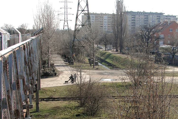
The site is defined by the Rákos-creek and the urban contexts surrounding its water-course. The strategic site comprises the whole six km section of the creek within the borders of the city district. Inside this area a large scale analysis is necessary to get a complete overview of the spatial/social background of the usage of the green strip. The coexistence of the various different urban structures on the study site generates a diverse character that lacks cohesion. The designated project sites seek links to existing or future developments such as leftover rail-tracks, new local city center with public amenities and housing estates. They also provide opportunities to define a new toolkit for dealing with public space issues all along the creek as elements of an overall strategy. The creek should be developed as the defining element of a new public space network reinventing the urban public life of the district.
Adaptability : main elements to take into account
The urban surrounding of the creek has huge potential considering the fact that the district does not have a civic center. The strip of the river has a relatively small width, yet even in its current state creates a network which defines a new type of centrality along a linear zone.
The creek offers connection to the 10th and 13th districts, but also connects urban tissues of completely different qualities. The direction of their future transformation (railway yards, new commercial development in the central area) has a great level of uncertainty. The task is to develop a network that would reconnect the pieces of the fragmented tissue and initiate new conditions at the level of the human scale that would serve as a generator of new developments and transformations. Since the context which defines the roles of the creek has an open future, the answers also have to be open at the levels of programme and intervention. The task is not merely a question of designing a new urban public space, but also an issue of reprogramming public spaces in line with the changing needs of the surrounding tissue. The vital issue is to set up an urban strategy to react to the uncertain conditions incorporating the time factor.
Competitors have to develop a multilayered solution, which deals with the complexity and the stratification assessment of the site and investigates the feasibility of the development. The main goal is to create an overall strategy on the whole area with interventions at an urban, architectural and infrastructural level, including visions for the project sites. The proposed designs could include strategies and toolkits for program/event based urban interventions.
Questions à propos du site
Is there any available file information concerning the cross section of the canal?
More than 60 sections of the existing situation of the creek at various points have been uploaded to the “New_docs_after_launch” folder.
What is expected to be included in the extra-information for registered competitors?
EUROPAN Hungary does not plan to provide new information besides the already handed over materials. Obviously if registered competitors request new materials we will carefully study the possibility of providing that information.
What is the water quality of the Rakos creek and are there contaminating businesses on the industrial areas next to the creek?
The most problematic contaminating sources ceased to exist about 10-15 years ago (most of the industrial plants in the area closed down, and since than it is only allowed to pour rainwater into the creek. All other waste-waters /sewage/ can only be let into the creek after cleaning). The quality of the water is the best at its rise and since contamination has dramatically decreased in the last decades inside the limits of Budapest the quality gets better and better inside the borders of the city (There are some contaminating sources in the region of Gödöllő, that lose their effect when the creek reaches Zugló).The last few years the quality can be considered acceptable. It is also underlined by several studies which demonstrated that biological activity (wild ducks, vegetation, algae) has increased considerably in and around the watercourse of the creek since than.
If there are, which are the (annual) events and festivals being organized and celebrated inside the Zugló district?
Some of the most important ones (a more detailed list is attached to the edited version of the competition site's answers attainable at the “New_docs_after_launch” folder):
- Zugló Festival held on the very first days of October; a series of cultural events connected to the “birthday” (October 1st) of the district municipality, mainly cultural events at various locations in Zugló.
- Zugló Cabbage Festival in late September: one day long event, basically a cooking competition with various accompanying programmes: concerts, handcrafts, wine-tasting; location: Sports ground of Rafc (see 4th page of “EUROPAN12_Budapest-Zuglo_elements_of_study_site.pdf” in the full site file) - video of this event
- Zugló Cultural and Sports Festival in May: one day long event with a possibility to try a large number of various events; location the same sports ground as above
The brief (p.20) says that 'the A1 panels have to contain a scaled plan of the whole project area (including the project sites and the strategic intervention sites - recommended scale 1:2500 - 1:5000) together with the surrounding public spaces. How is that to be understood? In scale 1:5000 only about 3/4 of the whole project site fits on one A1 panel. In terms of readability of a whole urban framework a higher scale would be necessary. Does the jury expect drawings at the recommended scale, in this case only parts of the whole project area? Please clarify.
It is not exclusively necessary to use the recommended scales, nevertheless as the brief clearly addresses we find it very important to include an urban framework plan of the whole area of strategic intervention sites and project sites. So the scale of this drawing is to the discretion of the competitors, but they have to aim to use an informative representation in a scale 1:10 000 or smaller (between 1:2500-1:10 000).
How much does the water level of the creek fluctuate? And, as happened before the straightening of the creek, was there any flooding in recent times?
The fluctuation of the water level is relatively low. At the point where Telepesi street crosses the creek (inside Strategic Intervention Site #2) the water level changes between 60 and 90 cm. At Fogarasi road (at the northern end of Project Site #5) the water level changes between 50-70 cm.
The last flooding when houses in the surrounding were endangered was in 1941.
Besides the above ground electricity line, is there also infrastructure that runs parallel to the creek under ground?
There are various minor public utility lines underground running parallel to the creek. Since they are not major infrastructural elements in case it is necessary they can be relocated.
Is the zoning plan in BUDAPEST-HU-SS-M2 file binding for our project, or can we derogate from it? In particular we would like to know which is the actual urbanistic destination of Rafc Stadion area, in the corner between Mogyorodi Utca and Rakos Patak. In the map it is indicated as a "housing estate" area, while in the description of the site Europan has given us it is defined as a public sporting area.
The zoning plan is not binding for the EUROPAN competition, but it is recommended to take it into consideration. Nevertheless the urban zoning plan in Hungary is a passive plan which delimits some possibilities (some future programmes), but does not delimit temporary uses and does not actively initiate to change existing uses.
Among the additionally provided information there is a series of labeled maps (called: BUDAPEST-HU-elements_of_study_site.pdf). There it is clearly indicated that today part of the block belongs to a private developer aiming to continue their housing program, while the other plot belongs to the municipality, currently managed by a sports association as a sports ground.
Where can we find any information about the XIII district urbanistic development plan ( Rakos-patak corridor) ?
Some plans of the district on the redevelopment of the creek have been uploaded to the “New_docs_after_launch” folder, including the Integrated Urban Development Plan and the zoning plan of the district and some pages of the creek redevelopment concept.
Could we have the rakos patak's water flow chart in m3/s over the course of the year? dry, medium and wet year -
The average discharge value for the creek is 0,27 m3/s. (more detailed information is available in the edited version of the competition site's answers attainable at the “New_docs_after_launch” folder)
Is there any information concerning the train tracks' use? Which ones are currently abandoned. Which are programmed to close or continue functioning?
There is no definite concept about the usage of the rail tracks (currently only two of them are used), nevertheless according to the currently available information from the Center for Budapest Transport (BKK) four rail tracks will be utilized in a long term. A pair of rail tracks will be used for long-range rail services, while the other pair will be used for suburban railway services. (see also map uploaded to the “New_docs_after_launch” folder on the railway lines to be used)
Is there any information/additional plans of the altitude points in critical places such as bridge crossings/ road crossings over the creek?
Several sections of the existing situation with altitude information (in relation to Baltic see level) have been uploaded to the “New_docs_after_launch” folder.
Le site est lié au thème suivant
Plateformes urbaines dynamiques La revitalisation d’espaces publics actuellement peu attrayants nécessite une réflexion à une échelle plus large que celle du site donné. Même s'ils sont parfois de petite taille, ces espaces sont des leviers stratégiques pour une dynamisation urbaine. Leur influence en termes d'identité et d'image dépasse souvent leurs limites physiques et appelle donc à une transformation plus importante du tissu existant. « Angles morts » n’ayant jamais eu une utilisation adéquate ou bien lieux dont la fonction initiale est aujourd'hui obsolète ou inadaptée aux besoins des habitants, ces sites peuvent servir de plateformes à une appropriation, de point de départ pour la mobilisation de la population locale ou d’un public plus large. L'aménagement ou réaménagement de ces zones peut être considéré de diverses manières : comme un rafraîchissement par des espaces multifonctionnels, avec des structures temporaires ou extensibles qui agissent comme des piqûres d’acupuncture ; comme un ballon d'essai ayant pour but de faire connaître un territoire donné, de déclencher un cofinancement ou investissement privé et d’identifier de nouveaux rythmes d'intensité.
Questions à propos du site
Pour pouvoir poser une question, vous devez être connecté (et, par conséquent, inscrit au concours).
Ve. 16 mai 2025
Date limite de soumission des questions
Ve. 30 mai 2025
Date limite de réponses aux questions
Avant de soumettre votre question, assurez-vous qu'elle n'apparaît pas déjà dans la FAQ.
Merci de poser vos questions sur les sites dans le menu Sites.
Merci de poser vos questions sur le règlement dans le menu Règlement.
Si votre question ne reçoit pas de réponse dans les 10 jours, merci de vérifier qu'elle ne figure pas dans la FAQ sous un autre intitulé ; sinon, contactez le secrétariat concerné par email (secrétariats nationaux pour les sites, secrétariat européen pour le règlement.)