Hammarö
Les Dossiers synthétiques et d'enjeux sont disponibles gratuitement.
Merci de vous inscrire et vous connecter pour accéder au Dossier complet de site.
- Dossier synthétique EN
- Le site sur Google Maps
- Retour à la carte
Données synthétiques
Category Urban - landscape - architectural
Team representative architect - urban planner - landscaper
Location Province of Värmland
Population City 15,000 inhab. Conurbation 110,000 inhab.
Strategic site 110 ha - Project site 20 ha
Site proposed by Municipality of Hammarö
Owners of the site Municipality of Hammarö
Commission after competition Urban project management role
Information complémentaire
How can the site contribute to the adaptable city?
Utopia reinvented
What is a neighbourhood?
What are its components?
Is it the buildings, the streets, the public places or the people in it?
Could a built heritage be the starting point for a new way of thinking about neighbourhoods?
The Hammarö site presents a unique opportunity to explore one of the most important questions of the future: How can we make use of the built heritage?
City strategy
The aim of the competition is to create an independent housing community with a clear ecologically and socially sustainable profile. Questions of energy, social interaction, services and new ways of living/working should be addressed. Also the slow growth must be considered; the project will have to be developed in stages, but each stage must be able to support itself. The project should manifest a clear identity. Connections to the surroundings are also important; access to the coastline, walking paths in the forests and along farmlands and maintaining existing natural qualities. Interventions must respect the scale of the site, and the existing buildings.
Site definition
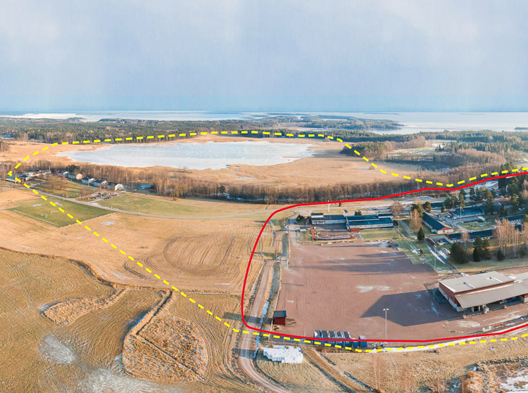
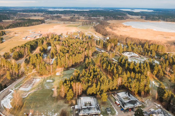
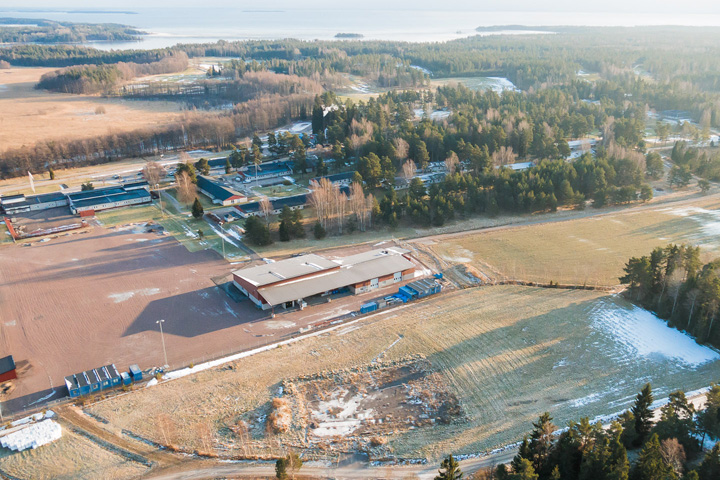
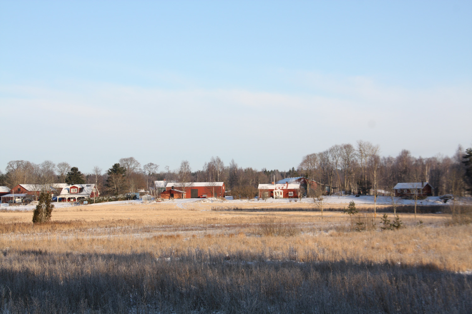
Hammarö is a growing municipality, the growth is slow but constant. The project site has several buildings. The total area of these are about 15 000 sqm, and most of them are nicely tucked into the terrain or between large pine trees. Some of them are empty; there is a restaurant, a kindergarten, a conference centre, smaller companies, and a server space for computers. There is a clear potential for denser housing to maximize the use of the existing buildings and infrastructure by reactivating these and using them as a complement to additional housing.
Adaptability: main elements to take into account
Sprawl restraint
Hammarö is a neighbouring municipality to the local hub Karlstad, a city with 62 000 inhabitants. Although Hammarö has some local industry, it depends heavily on Karlstad. The constantly growing municipality lies on a beautiful peninsula that reaches out into the largest lake in Sweden, Vänern. The area has untouched forests, farmlands and a scenic lake archipelago. Today most people here live in single family detached houses. The municipality owns little land and wants to find an alternative to the surface consuming suburban sprawl. The municipality owns a former nursing home for mentally disabled. It is a number of brick buildings in a serene patch of land. The nursing home and the land around it provide a unique opportunity for the municipality to pursue an alternative to commonplace suburbia.
Hammarö municipality has excellent living conditions. The project site is no exception. As one would expect most people here move by car which is why Hammarö is trying to improve public transportation.
Today the project site has a bus service, but with more residents this bus connection could be improved to conveniently link the area to Karlstad. Within the strategic site is the beautiful Sättersviken, a blue lagoon, with possibilities to place a marina and foot-bridges along the water.
Questions à propos du site
Are there any restrictions about the total area of the existing buildings that are about 15 000 sqm? Is it assumed they will remain with the same function than in the past? Are they fundamental in the whole project?
The question how to use the existing buildnings is very central to this site.
As shown on the site plan at page 10 in the full program, the current usage of the existing buildings span from commersially satisfactory usages (such us daycare centre, server space ect) to buildings that are empty today and only generate costs. Then in addition to this we have many buildings that today are rented out to very low rents in order to keep them inhabited. The municipality want to find functions in the long term that bring market level rents.
We have forwarded the question to the municipality and they will make some more research about what buildings shall keep their functions and what buildings can be opened up for new.
Therefore we will update the page 10 when we have the answers.
.................
Additional answer 15.04.13:
The municipality has overhauled the contract situation and therefore a new sit plan has been completed showing the current status of the different buildings. Since many contracts run over a very short time, it has to be emphasized that this is todays situation. We are sorry that the change comes this late.
A new plan will be uploaded in the after launch folder today.
Can the actual content and function of the 'Server space' be better specified? On pictures one can eg. see fences around the 'Server space', are these legal boundaries and can't be modified? Or can one imagine complimentary indoor/outdoor program to the 'Server spaces'? What kind of access do these facilities need? Trucks? How frequently are they accessed?
The brackets contain servers and racks for housing other companies' servers, and other installations. There are halls that have high demands for safety and security as the fence is to be regarded as permanent. The halls have backup systems and IT staff always nearby. But the building is not many who work but between 07:30 to 16:30 of personnel for technical administration. Another time, on-call. The property is staffed by security guards around the clock.
There comes a certain amount of goods to the property but no larger volumes continuous'd say. so the need for goods reception by truck.
Can the function/capacity/fuel of the 'Thermal Power Station' be specified?
This is a local power station with a capacity of 3.6 MW. It can be run on wood pellets or oil and supplies the Sätter area with heating and hot water.
What was the original function of the 'Server Space' buildings? When where they built?
These buildings contain server racks in wich companies can rent space. The buildings have been erected quite recently and are not excpected to be demolished, rebuilt or change their content in the forseeable future.
Are the trees in the project site under any kind of protection or can we make free use of this forest areas in the project site?
The old pine trees give character to the area and should preferably be preserved, smaller trees can be cut down.
Is there any kind of minimum/maximum hausing density recomended at the begining of the intervention? With how many housing should we start?
The area has a slow but growing population. about 100 new inhabitants per year.
Should we propose a new use for the vacant buildings? , can be this use residential?, could be some of this vacant buildings demolished? (plan 130415_plan_with _coded_buildings)
Several of the houses have such dimensions that they can be converted, however, it is the question of how cost effective this is, I do not think they are totally unfit. It may certainly be the subject of further investigation by the competition.
Some houses can certainly be relevant to demolish it can be motivated the area. However, there is a point in the using existing structures,
Should we strictly work in the project site or could we also work a bit with the borders of the project site?
As long as you give a motivation
All the new residential has to be into the project site limits?
Preferably, if not then motivate clearly why you think otherwise.
Wich one is the “former nursing home for the mentally disabled”? Should it stay there?
All of the white brick buildings are port of the former nursing home. The pivotal question of the competition is this: can a proposal make use of these buildings or should they be torn down?
”Sättersviken is in need of a better water circulation ... there have been discussions about opening up the old connection to Lake Vänern.” Should we consider this option as realistic?
If it is important for your proposal.
Does municipality property cover the whole Golf area? Can the actual boundaries of Golf Course be modified?
1.Yes. and 2.Possibly if well motivated.
Yes. Please motivate modifications.
What are the boundaries in terms of expected population? I mean, the site should be projected taking into account a grow of population per year. But, could you be more specific on this topic? Or, is it completely free -regarding to each proyect-?Thank you.
There is are no boundries, but there is a yearly influx of around 100 persons. There is a growth, but it's a slow one.
Regarding the golf site, in the aerial views, it's visible a golf space within the project site around the tennis court. Is it possible to build on it or do we have to keep it as it is? If so, which are the limits of the golf site?
The municipality owns the golf course. Building on it might be possible but has to be very well motivated.
How many companies are there in the office spaces? What is the occupation of them?
Please see : http://satterstrand.se/businesspark/
The following companies reside in the area today: Compare Testlab, Coromatic, Elanders Kort, Hammarö- och Sundstagymnasiet, Hammarö och Karlstad kommun, Karlstads Universitet, Kortdesign, Redpill Linpro, Roofac, Värmlandsbörsen, Kompetensmakarna, Tieto, Bikki Design, Natuvital, EKA Chemicals, Café Solsidan och Winwind.
Search the web for each individual company.
Should we preserve the existent trees in the Project area? Could you provide us with a tree situation plan? Thank You!
There are many old pine trees in the project site these are visible in the ortho-photo as well as in the short aerial film. These should be preserved, smaller trees can be cut down, if the proposal can motivate why.
Le site est lié au thème suivant
Patrimoine du futur Le patrimoine est réputé tourné vers le passé, mais on peut faire à l’opposé l’hypothèse qu’il doit être tourné vers le futur. Le patrimoine est normalement considéré comme extraordinaire, mais ne faut-il pas s’intéresser à la définition d’un « patrimoine ordinaire » ? Le patrimoine est habituellement évalué comme objet architectural, cet atelier s’interrogera sur les manières de « faire patrimoine » – dans trois types de contexte qui en sont a priori dépourvus : la mutation de quartiers déshérités, la reconversion de grands bâtiments ou d’îlots délaissés, le re-développement de zones d’activités ou d’enclaves abandonnées.
On peut faire l’hypothèse que plus la ville, dans sa morphologie comme dans son fonctionnement, enchevêtre, ressaisit et met en scène les époques ou les étapes de son développement, plus elle développe ses capacités d’adaptation au changement, ses potentialités d’évolution urbaine et ses chances de résister à des crises brutales. La question posée est donc : faire patrimoine, est-ce augmenter la capacité d’adaptabilité de la ville de demain ?
Documents spécifiques
Hammaro flyg
Questions à propos du site
Pour pouvoir poser une question, vous devez être connecté (et, par conséquent, inscrit au concours).
Ve. 16 mai 2025
Date limite de soumission des questions
Ve. 30 mai 2025
Date limite de réponses aux questions
Avant de soumettre votre question, assurez-vous qu'elle n'apparaît pas déjà dans la FAQ.
Merci de poser vos questions sur les sites dans le menu Sites.
Merci de poser vos questions sur le règlement dans le menu Règlement.
Si votre question ne reçoit pas de réponse dans les 10 jours, merci de vérifier qu'elle ne figure pas dans la FAQ sous un autre intitulé ; sinon, contactez le secrétariat concerné par email (secrétariats nationaux pour les sites, secrétariat européen pour le règlement.)