Kaufbeuren
Les Dossiers synthétiques et d'enjeux sont disponibles gratuitement.
Merci de vous inscrire et vous connecter pour accéder au Dossier complet de site.
- Dossier synthétique DE | EN
- Le site sur Google Maps
- Retour à la carte
Données synthétiques
Category Urban - landscape planning, architectural
Team representative Architect - urban planner - landscaper
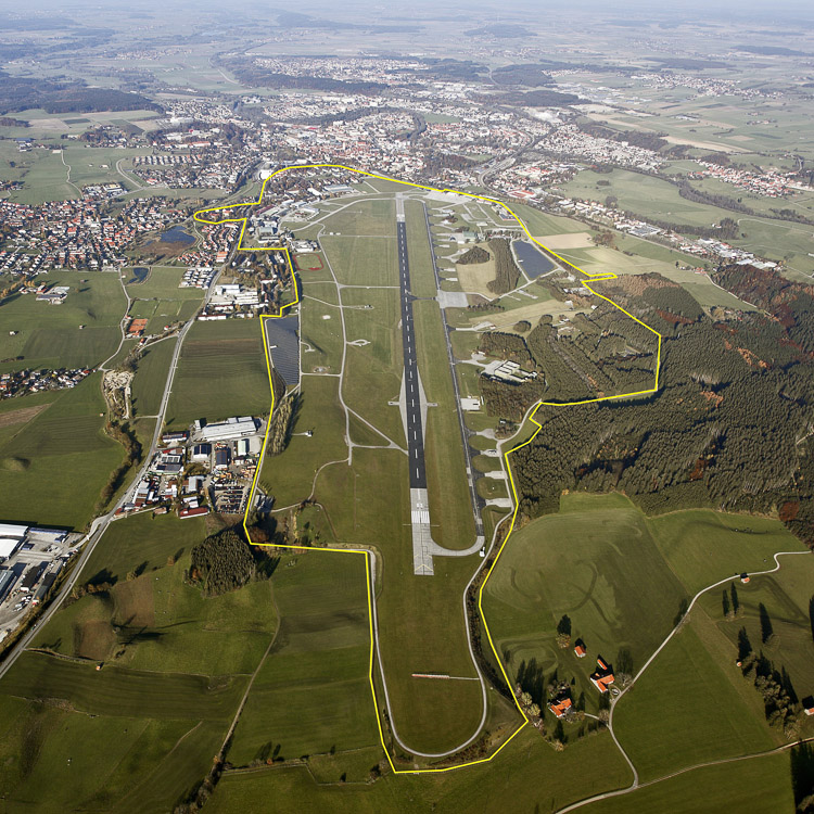
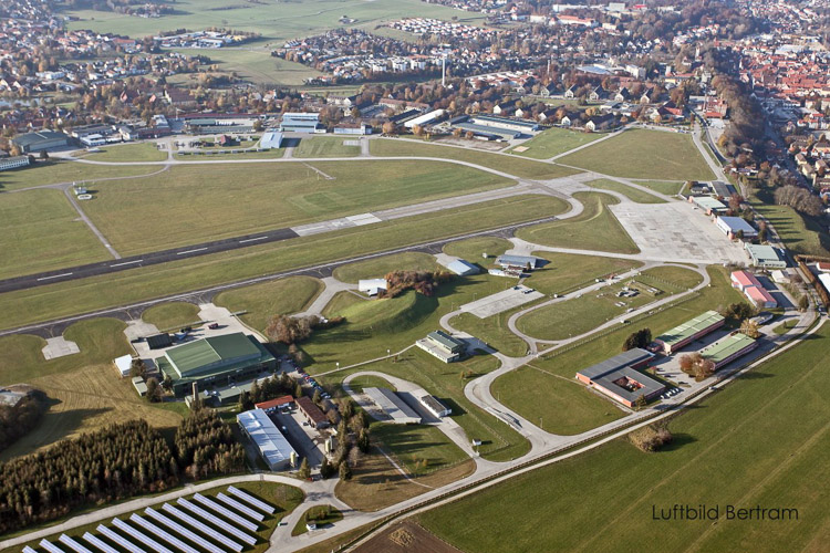
Location Kaufbeuren Air Base
Population 43,100 inhabitants
Strategic site ± 580 ha - Site of project 230 ha
Site proposed by Kaufbeuren Town Council
Owner of site Bundesanstalt for Immobilienaufgaben (Institute for Federal Real Estate: BImA) on behalf of the Federal Republic of Germany
Commission after competition Urban master plan; for the award of a planning contract a separate tendering procedure according to VOF will be required.
Information complémentaire
How can the site contribute to the adaptable city?
After many years of close links between the town of Kaufbeuren and the air base, which houses in particular the Luftwaffe Technical School, the announced closure threatens to cause a substantial loss of urban planning and structural functions with serious consequences for the town and the entire region. In the forefront the town council wishes to consider the consequences and changes in terms of urban planning, demography, economy, environment and opportunities for the future. Only a strategic approach will enable the opportunities ensuing from the conversion to be actively used. The town council is pursuing a combined approach of infrastructural measures, sustainable post-use concepts and cooperation models to cushion the effects of this significant structural incursion.
City strategy
The conversion of Kaufbeuren Air Base calls for a comprehensive examination of the urban planning, economic, supply management, landscape, environmental, demographic, social and cultural development of Kaufbeuren. According to the motto “Town in transition – Launching into an innovative development” the task will be to supply long-term impulses in the fields of research, education and the respective production areas as well as civil-military cooperation. In the sense of a campus, interdisciplinary synergies are to be combined with high-quality recreational/sports facilities and residential uses. The redevelopment proposals should also take account of the structural links between the site and the town centre, adjoining districts and neighbouring municipalities.
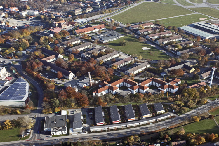
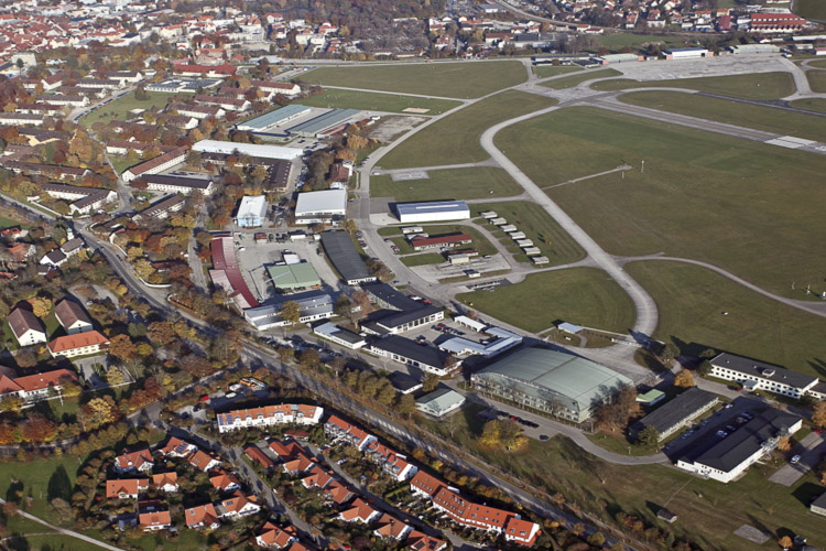
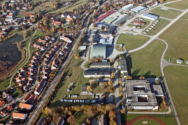
Standort site definition
The air base, erected between 1935 and 1938, is scenically located in the southern part of the town with views of the Alps. After World War II the runway was extended by 500 m to approx. 2200 m into the administrative district of Ruderatshofen. Today the site is approx. 230 hectares with a building complex (e.g. halls, lecture rooms, accommodation for course participants) in the north. The majority of the air base site is undeveloped, but occupied by the runway, meanwhile surrounded by important biotopes. The main access road is Apfeltranger Straße, which connects the site to the regional B 12 via the town centre.
Adaptability : main elements to take into account
As a first step in the redevelopment of Kaufbeuren Air Base, the Town Council commissioned preparatory studies with the participation of those concerned and the public agencies. The aim was to obtain an in-depth, interdisciplinary analysis from which an urban planning concept could be developed. The results of these studies form the basis for alternative uses with a number of possible scenarios that are critical for future development. The Kaufbeuren Air Base site must be redeveloped and restructured as an urban district. This re-orientation and change of use must be coordinated with regard to the consumption of resources and land usage. The surrounding urban area must be taken into account in this process.
In particular the links between the study area and the old town and adjoining neighbourhoods must be examined in consideration of the topography with the objective of integrating the relevant landscape features and key green elements into the urban planning concept. The objectives on an urban planning and settlement structure level must be directed towards a master plan that brings together the different use requirements in a robust and long-term, flexible urban planning, transport and landscape planning structure. The individual useable areas can be adapted or changed in the sense of clusters according to the medium- to long-term requirements. The time dimension for the process must be taken into account with a phased development concept that may also include intermediate uses.
Questions à propos du site
Will we be able to enter the Fliegerhorst Kaufbeuren during the site visit in order to have a better understanding of its buildings? Is it possible to enter the site privately on a date apart from the official site visit?
The inspection of the site has to be arranged together with the attendent, First Sergeant Wagner, during the site visit on 31 May 2013. There is no possibility to visit the site beyond the official site visit on 31 May 2013.
How large are the new functions (aviation related industry, colleges, trade-fair and conferences) expected to become?
Unfortunately no statement can be made regarding the dimensions of the potential new functions.
In the areal pictures it seems that there are some solar panels in the project area, is this correct?
Yes, there is a solar panel field in the project area.
The program says about the exisisting buildings: "The preservation and further use of buildings hinges mainly on the extent of modernisation and renovation work already completed, as far as this is already known." Is there more specific information about the excisting buildings available? Are there some buildings that already have been renovated? In der Auslobung steht zu den bestehenden Gebäuden: Deren Erhalt oder Ersatz durch Neubebauung steht somit im Ermessen der Wettbewerbsteilnehmerinnen und Wettbewerbsteilnehmer. Soweit bereits bekannt, setzen der Erhalt und die Weiternutzung der Gebäude wahrscheinlich meist umfangreiche Modernisierungs- bzw. Sanierungsmaßnahmen voraus. Können präzisere Informationen zu den Bestandsgebäuden geliefert werden? Gibt es Gebäude, die bereits renoviert wurden?
The airfield was constructed between 1935 and 1938 and was enhanced after World War II. The main buildings are halls, lecture halls and dwellings for the course participants. The building stock was constructed from 1950 on. Due to data protection there can not make any statements to the functions of the buildings.
Specific statements to the amount of modernisation or renovation work can not be made.
Der zwischen 1935 und 1938 errichtete und nach dem zweiten Weltkrieg vergrößerte Fliegerhorst weist seinen Bebauungsschwerpunkt in Hallen, Hörsäle und Unterkünfte der Lehrgangsteilnehmer auf. Der Gebäudebestand wurde ab 1950 errichtet. Aus Gründen des Datenschutzes können keine Aussagen zu den Funktionen erteilt werden.
Konkrete Angaben über den Umfang der bereits durchgeführten Modernisierungs- bzw. Sanierungsmaßnahmen können nicht erteilt werden.
The areal photos show more existing buildings than the dwg files - which document is more up to date? Have some of the buildings been demolished after the aerial photos are taken ? Die Luftbilder zeigen einen größeren Gebäudebestand als die dwg-Datei. Welches Dokument ist aktueller? Sind Gebäude abgerissen worden, nachdem die Luftaufnahmen gemacht wurden?
Article 73 paragraph 4 of the Bavarian building regulation (BayBO) or §37 paragraph 2 of the building law (BauGB) quote that projects that are intended for defence are not to be approved by the officials or the city government. Therefore the buildings of the airfield were not categorized. The aerial pictures are showing the actual buildings.
Art. 73 Abs. 4 Bayer. Bauordnung (BayBO) bzw. § 37 Abs. 2 Baugesetzbuch (BauGB) besagen, dass Bauvorhaben, welche der Landesverteidigung dienen, nicht von der Bauaufsichtsbehörde bzw. Gemeinde genehmigt werden. Daher wurde der Gebäudebestand des Fliegerhorstgeländes nicht katastermäßig fortgeführt. Die Luftaufnahmen zeigen die aktuelle Bebauung.
Is there any information (f.ex. construction year) available on the existing buildings and their current functions? Können Informationen (z.B. Angaben zum Baujahr) zu den bestehenden Gebäuden und ihren Funktionen bereitgestellt werden?
The airfield was constructed between 1935 and 1938 and was enhanced after World War II. The main buildings are halls, lecture halls and dwellings for the course participants. The building stock was constructed from 1950 on. Due to data protection we can not make any statements to the functions of the buildings.
Der zwischen 1935 und 1938 errichtete und nach dem zweiten Weltkrieg vergrößerte Fliegerhorst weist seinen Bebauungsschwerpunkt in Hallen, Hörsäle und Unterkünfte der Lehrgangsteilnehmer auf. Der Gebäudebestand wurde ab 1950 errichtet. Aus Gründen des Datenschutzes können keine Aussagen zu den Funktionen erteilt werden.
Following the site visit, we would like to ask for further data and maps, if possible: a map with the functions of the buildings inside the site area; a map with the state of preservation of the buildigns; the map with the year of construction of the buildings.
Moreover, only if available: weather and climate data and maps, in particular wind; data on the economic structure of the city we can refer to.
Due to the military use and reasons of data protection no maps are available. Weather and climate data can be found under here. Data on the economic structure can be found under here.
Is there a central to district heating in Kaufbeuren, that is possible to use to heat the buildings in the new urban area ?
No.
Can you explain in a better way the biotypes issue? it's necessary to preserve all of them?
There are extensive biotope structures on the site, in particular along the runway. These are marked in the plans. Precise details of the quality cannot be provided.The biotope structures should be taken into account in the planning, but do not need to be adhered to meticulously. Compensatory measures are possible.
it's possible to change the location of the solar panels (photovoltaic or solar?)?
Yes.
Is it necessary to remedy the ground of project area?
Extensive research on the subject of contamination began only recently. No specific information can as yet be provided.
Are the buildings on the site being used currently? What kind of uses do they have?
The building of the Kaufbeuren Air Base are currently used by the Luftwaffe Technical School with training facilities for technicians and air traffic controllers. Because of data security reasons no more detailed information can be given.
In the South-East part of the site there is an area listed as “SCHUTZZONE 3”, what does it mean in terms of building regulations?
Schutzzone III means an extended water protection area. This area is used as protection against long term contamination, especially chemical or radioactive pollution. Industrial plants which could be a risk for the ground water (i.e. petrol stations) are impermissible.
Is it possible to have some plans, section and elevation of the existing building in the airport area?
Due to the military use and reasons of data protection no maps are available.
The airfield was constructed between 1935 and 1938 and was enhanced after World War II. The main buildings are halls, lecture halls and dwellings for the course participants. The building stock was constructed from 1950 on. Due to data protection there can not make any statements to the functions of the buildings.
Specific statements to the amount of modernisation or renovation work can not be made.
What is the deepness of the Section of the Airport Track?
Approx. 30 meters.
Le site est lié au thème suivant
Ecorythmes La ville contemporaine cherche à anticiper l’avenir et à se préparer aux changements imprévisibles qu’il porte en lui. Différentes stratégies sont actuellement développées pour construire les conditions d’une résilience créative, donc à savoir s’adapter à un environnement changeant. L’hypothèse des Ecorythmes consiste à fonder le développement urbain sur une meilleure synergie entre les milieux naturels et urbains afin de rompre avec la logique d’opposition qui a conduit à un éloignement du citadin des réalités naturelles et à une dégradation progressive de celles-ci.
Cet éloignement du citadin et de la nature n’est pas seulement spatial, il est aussi temporel. En effet, le paysage n’est pas un tableau figé, une belle image, mais un milieu vivant où règnent des cycles (saisons, jour et nuit, marées, variations climatiques, vies faunistique et floristique…), des forces de croissance, des mouvements rapides ou lents, des migrations et transhumances, etc.
A l’inverse d’un urbanisme moderniste ayant privilégié une rupture entre les rythmes urbains et naturel, il s’agit, à travers les sites portant tous une dimension paysagère forte, d’encourager la mise en œuvre des processus opérationnels fondés sur le maintien, l’instauration ou la régénération de ces écorythmes.
Questions à propos du site
Pour pouvoir poser une question, vous devez être connecté (et, par conséquent, inscrit au concours).
Ve. 16 mai 2025
Date limite de soumission des questions
Ve. 30 mai 2025
Date limite de réponses aux questions
Avant de soumettre votre question, assurez-vous qu'elle n'apparaît pas déjà dans la FAQ.
Merci de poser vos questions sur les sites dans le menu Sites.
Merci de poser vos questions sur le règlement dans le menu Règlement.
Si votre question ne reçoit pas de réponse dans les 10 jours, merci de vérifier qu'elle ne figure pas dans la FAQ sous un autre intitulé ; sinon, contactez le secrétariat concerné par email (secrétariats nationaux pour les sites, secrétariat européen pour le règlement.)