Milano
Les Dossiers synthétiques et d'enjeux sont disponibles gratuitement.
Merci de vous inscrire et vous connecter pour accéder au Dossier complet de site.
- Dossier synthétique EN
- Le site sur Google Maps
- Retour à la carte
Données synthétiques
Category urban - architectural
Team representative Architect
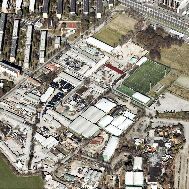
Location Milano - Porto di Mare
Population City 1,324,000 inhab. - Conurbation 20,000 inhab.
Strategic site ±490 ha - Site of project 36 ha
Site proposed by Councilor for Urbanism, Ada Lucia De Cesaris
Owner of the site Municipality of Milan
Commission after competition The project will be approved according to PGT and considering the reality and characteristics of the place. Under private financing for the implementation of the intervention through negotiated procedure through the integrated programme of intervention (PII) that will identify a specifically the scopes of intervention of private entities.
Information complémentaire
How can the site contribute to the adaptable city?
Due to its characteristics, the complexity of “Porto di Mare” site offers the opportunity to activate a public debate around the area‘s transformation. The architects are called to find solutions that involve and integrate environmental and social issues, which are at the same time constraints and priorities for the development of future interventions. For reasons related to the acquisition of the area, as well as for the time required to environmental claim, the site might not be available simultaneously in a single lot. It is necessary that the project is perfectly integrated with the concept of time adaptability, also keeping a landscape homogeneity and an overall character of usability and security.
City strategy
The Administration aims to implement a strategy of integrated and sustainable urban development, starting from the relationship between “fulls and empty spaces“, limiting construction and ensuring soil protection as a public resource. The PGT highlights the concept of public city, focusing on “urban empty spaces“, as projects opportunities able to produce innovation, urban quality and structuring function, ecological, environmental, to better enhance the „full“ of the built part of the city.
Priorities for quality urban space are the permeability, reducing land consumption and redefinition of services. The PGT articulates synergic choices to realize a proposal that includes a new social-housing offer with wide spaces for sport and green, respecting the rural reality and in connection with the Park.
Site definition
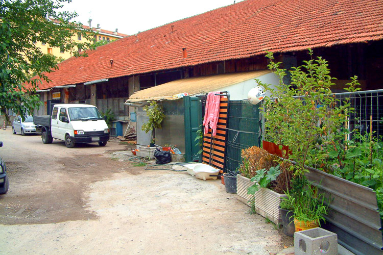
The site, on the sidelines of the consolidated urban fabric, in the South-Eastern city zone, leads to the system of Parco Agricolo Sud. It is named after a large port, which was to be built on the site, at the beginning of ‘900, to allow ship transportation from Milan to the Po’s river. After the first excavation, the project was abandoned and the docks filled since 1960. The area is characterised by a strong heterogeneity, occupied by: uncultivated open spaces that were partially used as landfill; spontaneous production activities/crafts operating without respect for the environment; heterogeneous and building fabric of poor quality except some pre-existi ng highly degraded rural heritage. Verifi cati on of soil pollution and its reclamati on are the beginning for the redevelopment of the area and its give back to the enjoyment of the quarter and the city.
Adaptability : main elements to take into account
The urban regeneration foresees a composite intervention, in which the urban and built regeneration is merged with the measures of social integration.
The strategic choices will be realized through some actions:
1-creation of a landscape project in a peripheral degraded area;
2-keep, strengthen and enhance the existing sports and leisure facilities;
3-operate the rehabilitation and filling existing consolidated tissue in particular, in connection with the Mazzini district, in the North;
4-locate a business incubator, that will be a driving force for new activities with a strong emphasis on environmental characters;
5-create a new urban centrality in proximity of the Metro station;
6-redesign, the infrastructures both perimetral and internal to the site, in order to facilitate East-West connection;
7-enhancing the historical heritage and those of typological and environmental special value.
8-promote the research around the sustainability and efficiency of this part of the city, aimed at saving and reducing consumption and application of sustainable and innovative energy systems.
9-activate social support actions to follow the stabilisation path of the existing settlements and activities also launched experimental forms of „diy“ (do it yourself).
Questions à propos du site
Is it possible to know more info about Contratto di Quartiere Mazzini, is it possible to meet some representatives?
In your download area we find the document about the Contratto di Quartiere Mazzini and a link web on this theme.
News about the possible meeting with new responsible for Contratto di quartiere.
All interested participant can meet Architect Daniela Farioli, in Via G.B. Pirelli n. 39 Milano - 2° piano corpo alto - stanza 2, according tothe following schedule: 7 may, 15:30; 8 may, 15:00; 9 may, 11-11:30
You can also send the question by email to info@europan-italia.com
Would it possible to operate a transformation on via Cassinis and the highway, downgrading it to urban boulevard till the station, letting it be a highway from the station onward?
You can think about proposals on the viability.
Please note that, although it is possible to propose new arrangements road system, in this case it could be difficult to implement the idea to downgrade the highway (which in the northernmost part is called Via Marochetti).
Just a clarification on the names of the streets. The street that borders to the north, the project area is Via Fabio Massimo.
Via Cassinis is beyond the highway and can be reached on the other exit of the subway station.
The aim of the project is also to think about a road connection in east-west direction.
In the report of the site visit, it is stated that two buildings are listed by superintendent. In which map is it highlighted? Which buildings should be preserved?
The Cascine S.Nazzaro and Carpana and Church San Filippo e Giacomo have historical and cultural bond (Art.10, d.Lgs.42/2004). Along Via Fabio Massimo historical buildings that are not bound (but that may be retained) are those shown in the picture, attached in the FAQ-E12-Milano-itaeng.pdf file on your download area.
The visit report mentions the future construction of two towers (Report-MILANO-IT-eng, page 2, point 8-via Barzoni). When are they supposed to be build? What are their caracteristics (exact location, height, etc.)?
Given the strong pressure of the local residents. It is a project which, at the moment, doesn't have the perspective of realization, We attach an overview of the workshop held with residents of via Barzoni, just to let you know of this. But we suggest you do not take into account this transformation in your proposal. (see the FAQ-2.pdf in your download web area)
Are there height restriction laws applying to the future buildings of the site?
There are no specific height limits, except for to check constraints airport of Linate (see tav. R08 of the Plan Rules of the PGT) which, for the area in question, provide a maximum height permitted in the share of construction equal to 147,85 meters above sea level. Of course the heght limits are also dictated by common sense.
What is the depth of the groundwater ?
The depth of the groundwater is 1 meter
What does "SLP massima accoglibile" mean ? (page 18 of MILANO-IT-C-Pr)
The maximum acceptable SLP = 127,719 sqm, it means the maximum area that you can realize within dell'ATU15.
In urbanism the SLP is generally the sum of the gross floor areas of all floors including the perimeter walls and internal ones. Every municipality, in their technical rules defining the areas covered by the SLP permitted and those that are excluded.
Franco Zinna, manager of the urban planning of Milano, has given, during the afternoon breafing, the indications of the Municipality of Milan on this area (see visit report).
La SLP massima accoglibile= 127.719 mq, significa la superficie massima che potete realizzare all'interno dell'ATU15.
In urbanistica per SLP si intende normalmente la somma delle superfici lorde di tutti i piani fuori terra comprensive dei muri perimetrali e di quelli interni. Ogni Comune, nelle proprie norme tecniche definisce le superfici che rientrano nella SLP consentita e quelle che ne sono escluse.
Il Dirigente del Comune di Milano ha dato, durante il breafing pomeridiano, le indicazioni del Comune di Milano su quest'area (Vd. report al sopralluogo).
All questions about surfaces and functions
All the questions about surfaces and functions are collected in a file that you can download in the complete Site Folder.
is it possible to accross the ATU perimeter for an expansion of the sport district?
The areas outside the perimeter ATU must be respect the rules laid down for the Agricultural South Park.
Is there a representation scale recommended for the urban design of the entire "project area"?
There is not a scale recommended. You are free to establish it according to your design.
It's possible to build pavilions with functions excluded from the calculation of SLP for the redevelopment of the south area along the road linking the station rogoredo? E possibile costruire padiglioni con funzioni escluse dal calcolo dell'SLP per la riqualificazione dell'area sud che costeggia la strada di collegamento alla stazione di rogoredo?
The indication of the area is not clear. In any case any structure outside the perimeter of ATU, although not included in the calculation of the SLP, must be respect the rules laid down for the Agricultural South Park. It should be noted that the area to the south, adjacent to Via S.Arialdo, is occupied by the former solid urban waste landfill.
could we have a more detailed census on the existing buildings in order to evaluate in a more realistic and concrete the eventual choice of any recoveries-reuse and changes of functional use of existing spaces also according to the probable reclamation?
Except the Cascine is possible to demolish and relocate the rest.
Pleas note that the relocation craft activities already in place can be expected in according to the residential functions assumed.
Would it possible to operate a transformation on via Cassinis and the highway, downgrading it to urban boulevard till the station, letting it be a highway from the station onward?
You can think about proposals on the viability.
Please note that, although it is possible to propose new arrangements road system, in this case it could be difficult to implement the idea to downgrade the highway (which in the northernmost part is called Via Marochetti).
Just a clarification on the names of the streets. The street that borders to the north, the project area is Via Fabio Massimo.
Via Cassinis is beyond the highway and can be reached on the other exit of the subway station.
The aim of the project is also to think about a road connection in east-west direction.
Le site est lié au thème suivant
Ecorythmes La ville contemporaine cherche à anticiper l’avenir et à se préparer aux changements imprévisibles qu’il porte en lui. Différentes stratégies sont actuellement développées pour construire les conditions d’une résilience créative, donc à savoir s’adapter à un environnement changeant. L’hypothèse des Ecorythmes consiste à fonder le développement urbain sur une meilleure synergie entre les milieux naturels et urbains afin de rompre avec la logique d’opposition qui a conduit à un éloignement du citadin des réalités naturelles et à une dégradation progressive de celles-ci.
Cet éloignement du citadin et de la nature n’est pas seulement spatial, il est aussi temporel. En effet, le paysage n’est pas un tableau figé, une belle image, mais un milieu vivant où règnent des cycles (saisons, jour et nuit, marées, variations climatiques, vies faunistique et floristique…), des forces de croissance, des mouvements rapides ou lents, des migrations et transhumances, etc.
A l’inverse d’un urbanisme moderniste ayant privilégié une rupture entre les rythmes urbains et naturel, il s’agit, à travers les sites portant tous une dimension paysagère forte, d’encourager la mise en œuvre des processus opérationnels fondés sur le maintien, l’instauration ou la régénération de ces écorythmes.
Documents spécifiques
Questions à propos du site
Pour pouvoir poser une question, vous devez être connecté (et, par conséquent, inscrit au concours).
Ve. 16 mai 2025
Date limite de soumission des questions
Ve. 30 mai 2025
Date limite de réponses aux questions
Avant de soumettre votre question, assurez-vous qu'elle n'apparaît pas déjà dans la FAQ.
Merci de poser vos questions sur les sites dans le menu Sites.
Merci de poser vos questions sur le règlement dans le menu Règlement.
Si votre question ne reçoit pas de réponse dans les 10 jours, merci de vérifier qu'elle ne figure pas dans la FAQ sous un autre intitulé ; sinon, contactez le secrétariat concerné par email (secrétariats nationaux pour les sites, secrétariat européen pour le règlement.)