Schiedam
Les Dossiers synthétiques et d'enjeux sont disponibles gratuitement.
Merci de vous inscrire et vous connecter pour accéder au Dossier complet de site.
- Dossier synthétique EN
- Le site sur Google Maps
- Retour à la carte
Données synthétiques

Category urban - architectural
Team representative architect - urban planner - landscaper
Location Schiedam Vrom-Koemarkt
Population City 76,500 inhab.
Strategic site ± 6 ha - Project site 2.2 ha
Site proposed by Municipality of Schiedam
Owners of the site Municipality of Schiedam and private owners
Commission after competition involvement of the winner in the realisaioon of the brief as supervisor of the public space. For the development of the real estate programme the municipality will endeavour to introduce the winners and their plan to the developing parties.
Information complémentaire
How can the site contribute to the adaptable city?
Schiedam is an old industrial city in the south of the Randstad conurbation, within the Rotterdam grid, well-known for its jenever (gin) industry. Schiedam has adapted well to developments as they evolved through the ages. Koemarkt has of old served as the entrance to the historical town centre: this is where Hoogstraat begins (or ends), and also Buitenhavenweg where the VROM site is situated. The differences in height, revealing how the former dikes were laid out to protect Schiedam from flood water, are distinctive features. The development of Koemarkt reflects the building periods and the approaches to urban planning in the last fifty years. Answers to economic and programmatical questions of today determine the feasibility of a first stage in a development that should be sustainable and conceived for the longer term.
City strategy
Schiedam is currently focusing on the regeneration and sustainability of the Nieuw Mathenesse business park, where the VROM site is situated, and which is also directly connected with Koemarkt. In the longer term, on the western edge of Rotterdam, a modern and innovative residential environment will develop on, and adjacent to, the waterside. Schiedam’s town centre will be the nearest centre for these newcomers with shops, catering establishments and cultural facilities. Koemarkt and the VROM site form an important pivotal point between the “old” jenever town and the modern distillery cluster developing on Nieuw-Mathenesse. An infill for the VROM site, an important but missing piece of the jigsaw next to Koemarkt, make this assignment a complex, but fascinating undertaking in the body of ideas regarding the adaptable city.
Site definition
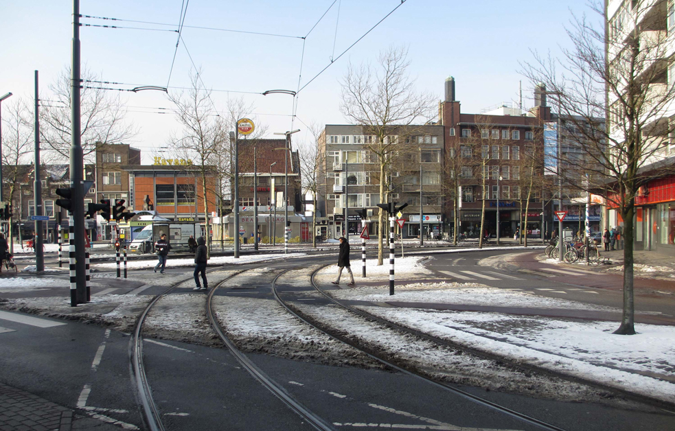
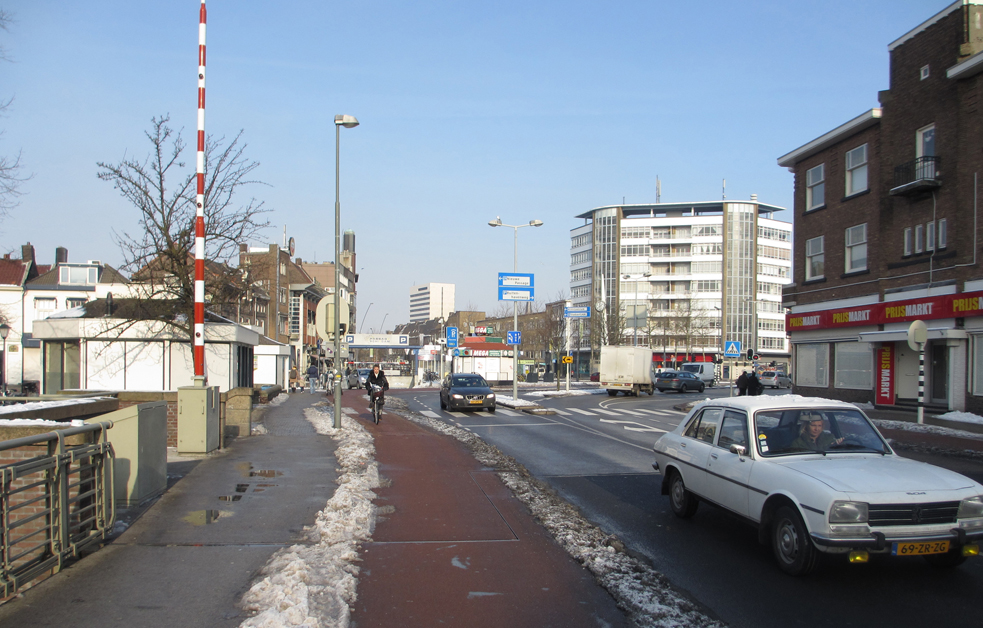
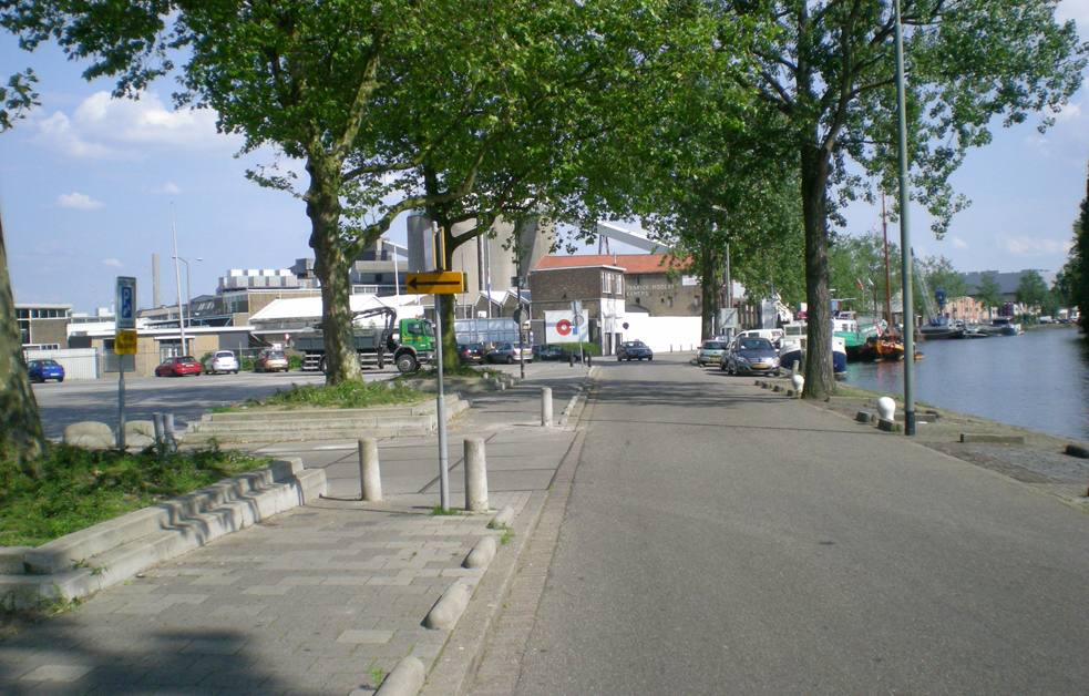
The Koemarkt and the VROM site are situated on the southern side of the city centre and, together, possibly form one of the city’s most interesting and visible locations. At the end of the nineteenth century Koemarkt was the tram terminus, the route ran from Rotterdam along Rotterdamsedijk forming a connection with Schiedam. The Europan site is also the spatial, pivotal point of the city. Here, the river Schie, quite literally, bends in the other direction and will become a major gateway to the city centre and a recreational area instead of being a traffic hub. Here the ambiance of the eighteenth-century city centre and the industrial character of the port converge in an exciting way. This site has the potential to expose this specific identity and quality of Schiedam.
Adaptability: main elements to take into account
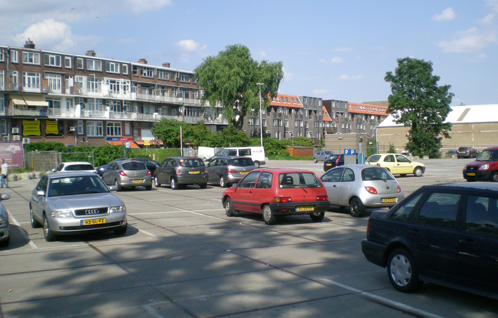
Koemarkt is a central point in Schiedam where several worlds converge: the eighteenth-century historical town centre, a late nineteenth-century neighbourhood and an early twentieth-century business park. The space between these three urban areas is currently dominated by infrastructure. Accents will indeed shift in the town’s main traffic structure creating space on Koemarkt. In the present urban structure the VROM site is situated “behind” the development on Koemarkt. The existing development on Koemarkt forms part of the intervention area. The adjacent VROM site is a unique location along the river Schie, situated between a nineteenth-century business park that still functions as such, and the historical town; however, it looks like a leftover space. Owing to the proximity of the glassworks and Koemarkt within a stone's throw, this location is hardly suitable for traditional programmes. What form of infill and significance can be given to Koemarkt and the adjacent VROM site? Part of the assignment is to give both places a new significance in the urban structure, possibly with a direct interconnection between the two. The enhancement and design of the spatial qualities of the water, functional blending, sustainability with emphasis on economic and cultural re-use, strategic and organic developments and imaginative programming of the plinths are elementary aspects in the assignment. The central question that applies to all infills is what basis can be established to enable this part of the town to become genuinely adaptable? How can a truly-sustainable intervention in the structure be deployed that will provide a strong foothold for the longer term?
Questions à propos du site
It says in the project documents that traffic over the bridge may be reduced to one lane. Is that one lane in total or one lane for each direction of traffic (two in total)? If it is one lane in total, what will be the direction of traffic and where will it go to/ come from: Broersvest or Rotterdamsedijk?
The answer can be found in document "1300610 QandA Schiedam 3", which is uploaded in “new documents after launching”.
In the text document is mentioned that the competition material comprises a document with the existing underground infrastructure as well as a tree inventory. We can’t find such a document. Is it already there or will it be placed in future?
The answer can be found in document "130531 QandA Schiedam 2", which is uploaded in “new documents after launching”.
Which elements (or activities) of the historical bank of the river Schie have to be preserved in order to maintain that historical feeling/vision?
The answer can be found in document "130527 QandA Schiedam 1", which is uploaded in “new documents after launching”.
What does the restructuring of Oost entail and what is the desired link between the revitalisation of the project site and Oost?
The answer can be found in document "130527 QandA Schiedam 1", which is uploaded in “new documents after launching”.
It is also important to create opportunities in all spheres of life for the new or temporal habitants of Schiedam, such as Middle and East European immigrants? Are they expected to stay or should only their living conditions be improved?
The answer can be found in document "130527 QandA Schiedam 1", which is uploaded in “new documents after launching”.
Could the “regional businesses” for the business parks on Rechter Maasoever be more defined/detailed?
The answer can be found in document "130527 QandA Schiedam 1", which is uploaded in “new documents after launching”.
What is the Havenroute, can a map of this route be made available?
The answer can be found in document "130527 QandA Schiedam 1", which is uploaded in “new documents after launching”.
In the map “spatial ambition” car traffic and public transport are not mentioned. How are they perceived, and which route will they use?
The answer can be found in document "130531 QandA Schiedam 2", which is uploaded in “new documents after launching”.
Is further analysis and elaboration of the significant roles that the routes, dikes and water play - in the past, present and future - required from the competition participants? If so, could more information be provided about the dikes?
The answer can be found in document "130531 QandA Schiedam 2", which is uploaded in “new documents after launching”.
Is it allowed to stretch the boundary of the strategic site in order to elaborate and detail the co-operation and relation between Oost and the respective site?
The answer can be found in document "130527 QandA Schiedam 1", which is uploaded in “new documents after launching”.
Could the light blue line cutting straight through Schiedam (in the “future structure”, left of city-centre) be explained? And why is Nieuw Mathenesse defined as pre-war residential area?
The answer can be found in document "130527 QandA Schiedam 1", which is uploaded in “new documents after launching”.
The legend in the analysis map City axis-the dikes is not clear, it doesn’t point out the described elements. Could it be clarified?
The answer can be found in document "130531 QandA Schiedam 2", which is uploaded in “new documents after launching”.
Will Broersvest become car-free in the future? If not, how will the traffic be connected from Koemarkt to Broersvest, connecting with Rotterdamsedijk and Oranjestraat?
The answer can be found in document "130531 QandA Schiedam 2", which is uploaded in “new documents after launching”.
Where - along Schiedam’s waterways - are the facilities for mooring pleasure craft are intended to take place?
The answer can be found in document "130527 QandA Schiedam 1", which is uploaded in “new documents after launching”.
Do the “smaller buildings with diverse facilities” have a protected status and are they owned by the municipality?
The answer can be found in document "130527 QandA Schiedam 1", which is uploaded in “new documents after launching”.
How are the accents in the city’s main traffic going to shift? What will be the new role of Broersvest?
The answer can be found in document "130527 QandA Schiedam 1", which is uploaded in “new documents after launching”.
Given the current socio-economic situation and future prospects of Schiedam, it seems that the impetus for the transformation cannot be directly/completely derived from the Vrom site. Is the prescribed sequence binding or, in other words, could the location that will instigate the process of transformation be adepted, without changing the eventual desired outcome for the development of Koemarkt and VROM site?
The answer can be found in document "130527 QandA Schiedam 1", which is uploaded in “new documents after launching”.
Since the original building of the former Hotel De Kroon has been drastically/brutally altered, what is the value of preservation for the municipality? Will the original façade be restored?
The answer can be found in document "130527 QandA Schiedam 1", which is uploaded in “new documents after launching”.
Is it allowed to argue the infill of the Vrom site being the first step of the long-term strategy and, with proper justifications, propose another starting point in the respective project site? Is it possible to derive from the assignment’s strategy as long as the result is the same or even better?
The answer can be found in document "130527 QandA Schiedam 1", which is uploaded in “new documents after launching”.
The image on page 22 of the text file lacks a legend: could it be provided?
The answer can be found in document "130527 QandA Schiedam 1", which is uploaded in “new documents after launching”.
Do the citizens of Schiedam need space for agricultural purposes? Are agricultural activities still of interest for Schiedam’s local economy?
The answer can be found in document "130527 QandA Schiedam 1", which is uploaded in “new documents after launching”.
Will Broersvest come again to a dead end – this time at Koemarkt – at Koemarkt and at ’s-Gravelandseweg, to create a car-free area for pedestrians, acting like a centre?
The answer can be found in document "130527 QandA Schiedam 1", which is uploaded in “new documents after launching”.
With respect to the build-up area of Oost, is there still the desire to tuck away the small-scale development like was done by designing the flat building?
The answer can be found in document "130527 QandA Schiedam 1", which is uploaded in “new documents after launching”.
Could you explain what “Aschstal” exactly entails and provide a picture?
The answer can be found in document "130527 QandA Schiedam 1", which is uploaded in “new documents after launching”.
Will the water quality at Buitenhavenweg be sufficient to be used for swimming?
The answer can be found in document "130527 QandA Schiedam 1", which is uploaded in “new documents after launching”.
What are Schiedam’s most important industrial activities besides the distillery and glass factory?
The answer can be found in document "130527 QandA Schiedam 1", which is uploaded in “new documents after launching”.
Who owns the empty/abandoned parcels bordering Buitenhavenweg from ‘De Plantage’?
The answer can be found in document "130527 QandA Schiedam 1", which is uploaded in “new documents after launching”.
Is further revitalisation planned by the municipality for the empty and decayed warehouses?
The answer can be found in document "130527 QandA Schiedam 1", which is uploaded in “new documents after launching”.
Can the Municipality deliver blueprints of the apartment block along Rotterdamsedijk with their backs facing VROM site?
The answer can be found in document "130527 QandA Schiedam 1", which is uploaded in “new documents after launching”.
What is the traffic model of the new traffic way via Van Deventerstraat and what is its volume?
The answer can be found in document "130527 QandA Schiedam 1", which is uploaded in “new documents after launching”.
Which public facilities and amenities are present in Schiedam and in the relevant neighbourhoods in Rotterdam?
Some summary information in English can be found on www.ontdekschiedam.nu.
Which part(s) of the housing block along Rotterdamsedijk is owned by the municipality and/or an other public body?
Rotterdamsedijk 441-I is owned by the municipality and concerns shop premises. The municipality also owns Buitenhavenweg 9. This is the tourist Information Office (VVV) and the building is municipal listed. Also see SCHIEDAM-NL-SS-M13 in the file “new documents after launch”.
What is the required air draft for any new bridge above the river Schie?
The answer can be found in document "130531 QandA Schiedam 2", which is uploaded in “new documents after launching”.
Is possible to improve the relations between the project site and the river Schie by working on its banks? Is there any need for parking barges along the banks?
The answer can be found in document "130531 QandA Schiedam 2", which is uploaded in “new documents after launching”.
Is Broersvest a 30 km zone street and will Rotterdamsedijk and Koemarktbrug be 30 km zone streets in the future?
No, Broersvest, Rotterdamsedijk and Koemarkt bridge are town main roads (50 km/h). Actual speed, however, is slower at Koemark (about 30 km/h). The preferred profile – two times one lane and centre strip – promotes a quiet driving behaviour.
Is, besides the “functional master plan”, a master plan available for the Vrom site in Nieuw-Mathenesse, showing the design of the area?
Not really, the area was deliberately not designed in terms of urban design. Important is the (spatial) zoning plan (bestemmingsplan) and environmental rules applying on this site. There are rules applying on the area for urban aesthetics.
Does a Dutch construction material price list exist and could it be made available for the competition participants?
No public information can be communicated, unless from the consumer markets, but those prices are not representative for the building trade.
What are the building rules for the project site concerning building height, distance between existing and new development, etc?
The answer can be found in document "130531 QandA Schiedam 2", which is uploaded in “new documents after launching”.
How many and what kind of ships pass the project site?
The answer can be found in document "130531 QandA Schiedam 2", which is uploaded in “new documents after launching”.
Is it possible to act under Koemarkt street level to sort the traffic flow?
The answer can be found in document "130531 QandA Schiedam 2", which is uploaded in “new documents after launching”.
p21 of the programme document describes the surface area of the Vrom site as 6,000 square metres. The mix with maximum business programme suggests 7,000 square metres on one layer. Could this be clarified?
The answer can be found in document "130531 QandA Schiedam 2", which is uploaded in “new documents after launching”.
What do GSI and FSI mean?
GSI is Ground Floor Index; FSI is Floor Space Index.
Why is Nieuw Mathenesse defined as pre-war residential area?
The answer can be found in document "130527 QandA Schiedam 1", which is uploaded in “new documents after launching”.
Could demographic data be provided concerning the actual population of Schiedam (income, education, age, households etc.) and the desired target group in case of a housing scheme for the Europan site?
The answer can be found in document "130531 QandA Schiedam 2", which is uploaded in “new documents after launching”.
Could a map be made available showing the perimeter of the industrial buildings converted into housing and the industrial buildings that should get new functions?
The answer can be found in document "1300610 QandA Schiedam 3", which is uploaded in “new documents after launching”.
An earlier answer states that some buildings are listed. Is it possible to propose demolition of one of these buildings?
The answer can be found in document "1300610 QandA Schiedam 3", which is uploaded in “new documents after launching”.
The question is forwarded to the municipality. As soon as the answer is given it can be found here.
Is it conceivable to modify the road course of Buitenhavenweg and make it pass over the Vrom site or should it stick to its actual path along the banks?
The answer can be found in document "1300610 QandA Schiedam 3", which is uploaded in “new documents after launching”.
Is it possible to open passages on the ground floor in the buildings along Rotterdamsedijk close to the Vrom site in order to connect the Vrom and Koemarkt areas?
The answer can be found in document "1300610 QandA Schiedam 3", which is uploaded in “new documents after launching”.
Could the nuisances caused by the glass factory and the distillery cluster (noise, air) be defined?
The answer can be found in document "1300610 QandA Schiedam 3", which is uploaded in “new documents after launching”.
What are the measures that were and will be taken to integrate the distillery cluster into its close surroundings and ensure a better quality of living for the neighbourhood (adaption of the buildings, measures to avoid air pollution, measures regarding energy efficiency and production of energy, etc.)
The answer can be found in document "1300610 QandA Schiedam 3", which is uploaded in “new documents after launching”.
Is it possible to make available blueprints and illustrations of the renovation plans of the glass factory?
The answer can be found in document "1300610 QandA Schiedam 3", which is uploaded in “new documents after launching”.
Could the details of the different plots and properties within the distillery cluster be made available?
The answer can be found in document "1300610 QandA Schiedam 3", which is uploaded in “new documents after launching”.
Could the innovative distillery cluster be considered to evolve and restructure (via downsizing) in a near future in order to make possible new urban connections and benefit from interesting built volumes?
The answer can be found in document "1300610 QandA Schiedam 3", which is uploaded in “new documents after launching”.
Is it true that neither in the short nor in the mid term the distillery cluster will be transformed into a new mixed urban development?
The answer can be found in document "1300610 QandA Schiedam 3", which is uploaded in “new documents after launching”.
Is it possible to provide more details or documents on the master plan for the distillery cluster?
The answer can be found in document "1300610 QandA Schiedam 3", which is uploaded in “new documents after launching”.
Is the limit of the project site strict? Could it be overtaken by means of light constructions over the river?
The answer can be found in document "1300610 QandA Schiedam 3", which is uploaded in “new documents after launching”.
Le site est lié au thème suivant
Plateformes urbaines dynamiques La revitalisation d’espaces publics actuellement peu attrayants nécessite une réflexion à une échelle plus large que celle du site donné. Même s'ils sont parfois de petite taille, ces espaces sont des leviers stratégiques pour une dynamisation urbaine. Leur influence en termes d'identité et d'image dépasse souvent leurs limites physiques et appelle donc à une transformation plus importante du tissu existant. « Angles morts » n’ayant jamais eu une utilisation adéquate ou bien lieux dont la fonction initiale est aujourd'hui obsolète ou inadaptée aux besoins des habitants, ces sites peuvent servir de plateformes à une appropriation, de point de départ pour la mobilisation de la population locale ou d’un public plus large. L'aménagement ou réaménagement de ces zones peut être considéré de diverses manières : comme un rafraîchissement par des espaces multifonctionnels, avec des structures temporaires ou extensibles qui agissent comme des piqûres d’acupuncture ; comme un ballon d'essai ayant pour but de faire connaître un territoire donné, de déclencher un cofinancement ou investissement privé et d’identifier de nouveaux rythmes d'intensité.
Documents spécifiques
Presentation of the site in Schiedam - Information Market, March 23, 2013
Round table with Dutch Site Representatives - Information Market, March 23, 2013
Questions à propos du site
Pour pouvoir poser une question, vous devez être connecté (et, par conséquent, inscrit au concours).
Ve. 16 mai 2025
Date limite de soumission des questions
Ve. 30 mai 2025
Date limite de réponses aux questions
Avant de soumettre votre question, assurez-vous qu'elle n'apparaît pas déjà dans la FAQ.
Merci de poser vos questions sur les sites dans le menu Sites.
Merci de poser vos questions sur le règlement dans le menu Règlement.
Si votre question ne reçoit pas de réponse dans les 10 jours, merci de vérifier qu'elle ne figure pas dans la FAQ sous un autre intitulé ; sinon, contactez le secrétariat concerné par email (secrétariats nationaux pour les sites, secrétariat européen pour le règlement.)