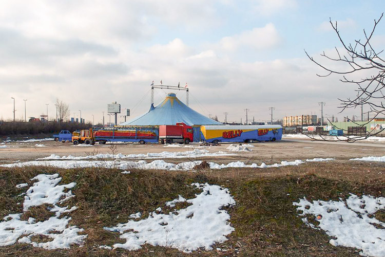
Wien - Kagran
Les Dossiers synthétiques et d'enjeux sont disponibles gratuitement.
Merci de vous inscrire et vous connecter pour accéder au Dossier complet de site.
- Dossier synthétique EN
- Le site sur Google Maps
- Retour à la carte
Données synthétiques
Category Urban
Team representative architect - urban planner - landscaper
Location Wien, Donaustadt
Population 1,750,000 inhabitants
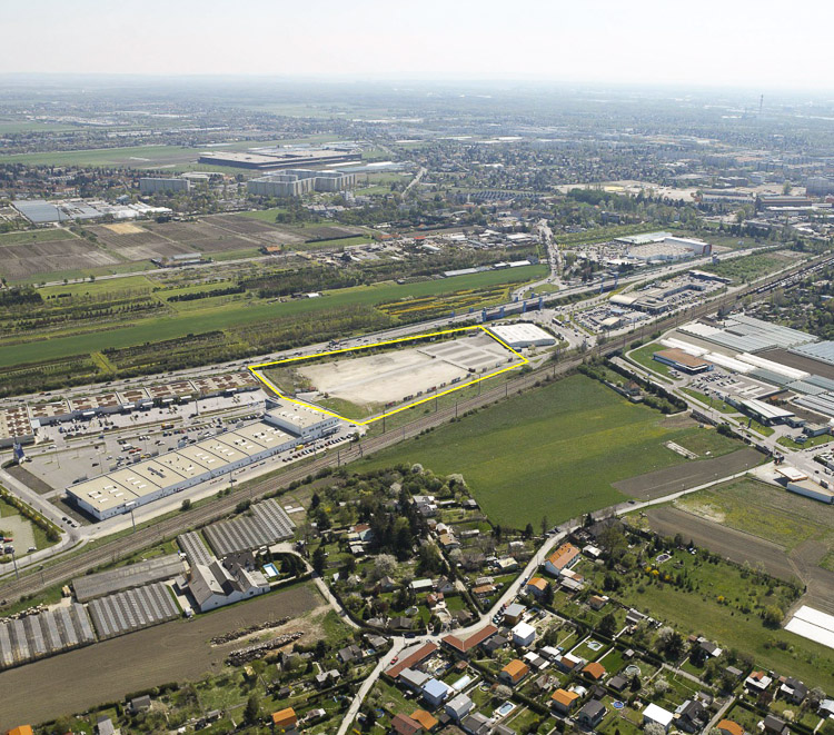
Strategic site 40.3 ha - Site of project 3.2 ha
Site proposed by City of Vienna and site owner
Owner of the site private developer
Commission after competition urban study + involvement in the implementation process of the architectural pilot project
Information complémentaire
How can the site contribute to the adaptable city?
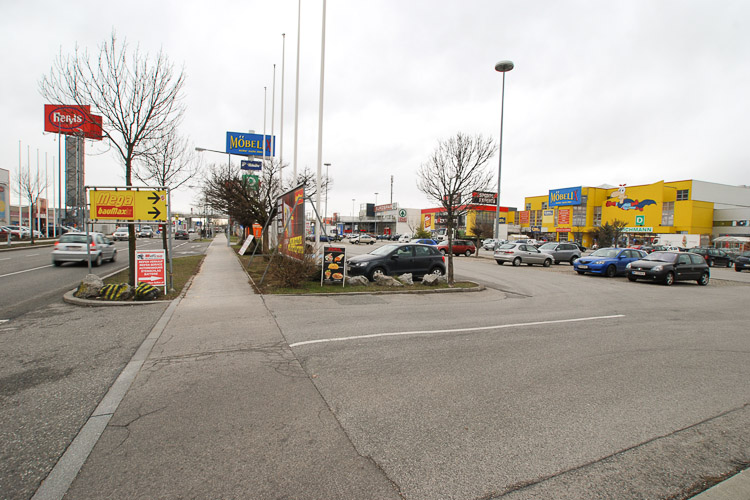
The area is completely based on the logics of car and truck-driving which characterizes the rhythms, dimensions and the texture of the space, adapted to individual motorized traffic without coordination with other means of mobility.
How can one intervene in this specific economy which dominates the structure of shopping, adapting it to a more sustainable development of space and time, including the issues of identity and place?
How can the commercial area be transformed into an attractive urban quarter, with housing infiltrating its mono-functionality and gradually re-shaping the space?
City strategy
Being confronted with a strong growth in population - every year 20.000 new inhabitants - the city of Vienna focusses on various scenarios of densification. This includes the consolidation of the inner city (e.g. the development of railway station areas) as well as the planning of a large satellite towns (Seestadt Aspern). Another focus is the conversion of large diffused areas in the outer districts where the potential of growth goes hand in hand with the challenge of introducing a „new idea of city“ and re-qualifiying these places. The study area belongs to the latter category, as a commercial area with the potential of densification owing to the introduction of a new tramway line across the site.
Site definition
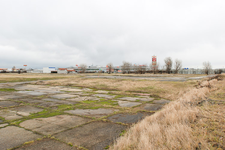
The site is squeezed between two heavy infrastructures, the railtracks of the rapid train (leading to Bratislava) and the motorway which isolates the area as well as it links the site to the regional traffic network. Contrary to a mall, the two commercial parks function as a sum of autonomous shops with separated parking areas and access. Fragmentation reaches a climax in this situation. One part of the study area lies empty: the site of a former oil production plant where decontamination is only partly resolved but long-term development is possible.
Adaptability : main elements to take into account
The site at Stadlau is a perfect test case for such an adaptation of the existing city fabric to new demands. It is exceptionally well connected to the regional street network. It has a high potential of gradient conversion, due to the small scale of lots and buildings. In the near future it will be connected to the network of public transport, thereby breaking up its isolation.
How can the impact of the new tramway stop be exploited in order to develop a new kind of urban quarter around this node within the next decades? How can a hyper-fragmented, “car-driven” area be converted into a sustainable and attractive urban quarter without neglecting the current reality? How can the existing structure adapt, step by step, to another idea of urbanity? How can a different dialogue between the built and its in-between spaces be initiated in order to allow for a more comfortable and sustainable use of the area?
Questions à propos du site
Do you want to remove all the existing retail stores from the project site during the next 30 years?
Projects shall test the ways in which the study area can be transformed during the next decades. However, a mix of uses seems desirable, integrating the retail stores and creating a new character for the area through superimposition of uses rather than through their replacement.
Can you send a dwg or pdf drawing of the future highway ramp?
Schematic information will be provided, detailed plans are not existing yet and cannot be provided for the competition.
Can you send a dwg or pdf drawing of the tramway line (elevated tracks) and tramway stop?
Will be uploaded soon.
What does FAR means?
FAR is short for 'Floor Area Ratio'. It specifies the built density on a given site.
As a formula: Floor area ratio = (total covered area on all floors of all buildings on a certain plot) / (area of the plot)
Is it possible to receive any kind of document to understand how much space the ramp at the site’s southern tip will take?
Schematic information will be provided, detailed plans are not existing yet and cannot be provided for the competition.
Which is the English translation of the MA – 21 B GIS Grundlagen key?
A translation will be provided. See further uploaded material.
Is there any kind of restriction about subsoil use, especially about water?
There is no special restriction. Ground water level is at an average of 3m below ground level. Underground constructions (f.e.parking garages) have to be constructed accordingly.
Which is the distance that buildings have to keep from the railway and from the motorway?
The projects shall test the possibilities of the site: Minimum distance is given by the limits of the building lots. Noise pollution has to be taken into account, but not necessarily by keeping a bigger distance.
Are the railway tracks only for freight trains or also for the rapid train that leads to Bratislava? Which is the frequency of these trains and what they connect?
The railway tracks are (since 2012) only used by freight trains. Between train station / subway stop Stadlau (U2) and Gerasdorf there are no passenger trains. To Bratislava there is a direct connection from Stadlau ("Marchegger Ast"), which will be upgraded to a double track line in the next years. On the railway tracks west of the study area, freight trains pass by irregularly, but several times per day. These trains deliver goods to the old station at Breitenlee where they are loaded onto trucks.
Is it possible to use the railway tracks for local transportation, for ex. for a tramway?
No. The railway tracks are currently in use but only for freight trains.
What does the map WIENKAGRAN-AT-SS-M1 (2) refer to?
WIENKAGRAN-AT-SS-M1 is the zoning plan for the area, specifiying building height, uses and maximum outlines. We will upload the key to the main elements of this plan. The area marked in red signifies that no new buildings may be erected in this zone. WIENKAGRAN-AT-SS-M2 shows the territorial strategy of the city planning department, with zoning on a larger scale. We will also provide a translation of the key shown on this map.
Is it possible to receive some more information about the Breitenleer Strasse Station? Is it possible to renovate it or to move it?
The train station Breitenleer Straße has been closed down in 2010. Since then, the railway line is only used for freight trains. There are no plans to reactivate the rail tracks and the station for passenger trains.
How should we manage the contaminated part of the site?
Contamination is under control for now, as long as the site remains empty. "Superficial" uses, which do not interfere with the ground are possible. Decontamination of the site becomes only necessary when new buildings are erected. New constructions on this site are therefore more costly and will only happen if the demand is big enough. Intelligent ideas for a gradual transformation and decontaminationof the site through landscape interventions should be developed in the projects.
Which are the opening and closing times of the commercial parks shops?
Depending on the type of shop, opening times are from 8.00 or 9.00 in the morning to 18.30 or 19.00 in the evening during the week, on Saturdays until 18.00 maximum. On Sundays all shops are closed.
Is it possible to receive a map of the traffic flow of the site?
A traffic census will be provided. See uploaded material.
Where can we find the law concerning high rise buildings in Vienna?
The High rise concept of the city of Vienna can be seen here (in german). The most important points are the following:
1) The site has to fulfil the requirement of excellent conncetion to public transport. That means that either one subway or two different tram lines have to stop in the vicinity: the distance may not be more than 300m.
2) "Two-hour-shadow": the windows of occupied rooms (as opposed to service space) of any neighbouring buildings (existing or to be built in the future) may not be in the shadow of the high rise building for more than two hours on 21st of March.
3) High-rise building have to offer some sort of social or cultural surplus-value to their neighbourhood.
Since the requirement mentioned before is not given at the moment, a high rise development can only be seen as a long term scenario and has to go hand in hand with a fundamental transformation of the study area.
Is there any kind of restriction about airport respect areas?
No.
Could you please give us a dwg file with the level curves of the project site?
Currently, we do not have such information. We will try to get it and upload it if possible.
About the limit of 35 m height. Is it referred to the overall height of the building or to the top floor which can be reached from the common communication?
According to regulation OIB 2.3 (buildings with uppermost level above 22m), there is a difference between buildings with an uppermost level is at 32m or above 32m. This distinction is important as to evacuation. The height of the roof top is not an issue, therefore. Theoretically, of the uppermost floor space is higher, buildings can be higher than 35m, if zoning and the building code allow for it.
Which are the regulations for the distances between the buildings? 45°, 60°? Are there any other norms we should take into account?
The Viennese building code applies. An English translation of some important parts will be uploaded soon. For now: 45° from the obligatory windows of used rooms (not access areas or similar uses), with the possibility of a slight reduction if light enters sideways.
How many parking lots should be designed considering the industrial and commerical functions?
One car per apartment, one car per 80 sqm net floor area used by people (for example, storage areas do not count)
Could you provide us the general design project of the area located on the south west of the strategic site?
The challenge is how to communicate the overall strategy for the study site. The scale of representation can be adapted to the logic of the proposals. An overview in 1:2000 with zooms is possible, as well as a more diagrammatic representation.
Regarding the information for the panels you are asking for a site plan with ground floors and public spaces in 1:1000. This scale does not fit into a A1. How should we behave?
Currently, we do not have such information. We will try to get it and upload it if possible.
Is it possible for trees to grow on contaminated part of the ground and if not which plants are could grow there?
The collaboration with landscape architects is recommended in order to develope feasible concepts for the treatment of the contaminated area.
we do not find any information about the new big road cross point in the south of the area. you sent us a file with circular "area" that we have to respect, but how car's fluxes work? do we still have a car acces from the south (like the existing one) to our area? thanks a,lot
The new road will pass under the highway, more or less in the same way Hirschstettener Straße does at the moment. The loop south of the project site will be an entrance to the highway going south for cars coming along the new road from the east. The loop will start at the lower level and rise to the level of the highway. The car access to the site will remain more or less the same, mainly from the road passing by west of the project site, right beside the railtracks. Existing topographic differences have to be considered. We are working on a document that will clarify the topographic situation.
Do you know how the new road will cross the highway before reaching the site? Above or below?
The new road will pass under the highway, more or less in the same way Hirschstettener Straße does at the moment. The loop south of the project site will be an entrance to the highway going south for cars coming along the new road from the east.
Le site est lié au thème suivant
Entre-temps L'adaptabilité, c’est aussi donner aux procédés d’élaboration d’un projet la possibilité d'intégrer de façon créative l'incertitude, le manque de financement, le rôle inconnu de la compétition du site donné à l'avenir, ou même les transformations territoriales de longue durée qui l’affecteront.
Comment, en effet, la « période d'attente », avant la mise en œuvre d'un projet, pourrait-elle être structurée de manière à faciliter des scénarios multiples, à impliquer de nombreux acteurs, à permettre enfin des transformations éventuelles de la vision initiale des aménagements urbains ? Dans un tel cas, l’adéquation et l’intelligence du projet pourraient être assurées par des procédés de toutes sortes façonnés en continu par la dynamique du contexte du territoire. En d'autres termes, il s’agirait de laisser le temps au projet d’évoluer de façon organique, de croître tel une plante enracinée dans le site-même.
Questions à propos du site
Pour pouvoir poser une question, vous devez être connecté (et, par conséquent, inscrit au concours).
Ve. 16 mai 2025
Date limite de soumission des questions
Ve. 30 mai 2025
Date limite de réponses aux questions
Avant de soumettre votre question, assurez-vous qu'elle n'apparaît pas déjà dans la FAQ.
Merci de poser vos questions sur les sites dans le menu Sites.
Merci de poser vos questions sur le règlement dans le menu Règlement.
Si votre question ne reçoit pas de réponse dans les 10 jours, merci de vérifier qu'elle ne figure pas dans la FAQ sous un autre intitulé ; sinon, contactez le secrétariat concerné par email (secrétariats nationaux pour les sites, secrétariat européen pour le règlement.)