Barreiro
Les Dossiers synthétiques et d'enjeux sont disponibles gratuitement.
Merci de vous inscrire et vous connecter pour accéder au Dossier complet de site.
- Dossier synthétique EN
- Le site sur Google Maps
- Retour à la carte
Données synthétiques
Category landscape – architectural
Location Barreiro Municipality
Population 78,764 inhab.
Strategic site 27.71 ha - Project site 3.35 ha
Site proposed by Município do Barreiro
Owner(s) of the site Transport companies and Municipality
Commision after competition Partial urban study, subject to scenario and actors definition
Team representative architect
Information complémentaire
How can the site contribute to the adaptable city?
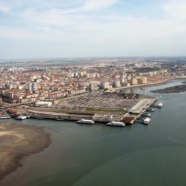
Main challenge of the site is to adapt and transform a transport interchange space, reversing its process of decay and obsolescence, with a new meaning and wider territorial integration. Within a city waterfront urban regeneration process, the aim is to develop a new centrality, combining heritage and landscape current features with new activities. Its outstanding position allows rebuilding the connections with the city and neighbouring fragmented territories: over the river linking to a closer town (Seixal) and a better integration with surrounding urban fabric. The location and diversity of elements demand solutions to be versatile and flexible, envisioning they can be phased or independently built, always ensuring intervention´s global and state coherence.
City strategy
Located in Lisbon Metropolitan Area (LMA) within the Tagus estuary, Barreiro has a long industrial history still reflected in its urban landscape and strong identity. The city intends to developed regeneration strategies for large deactivated industrial spaces, with new and more diverse activities. This is the opportunity to repair the urban fabric and to connect it to other LMA nucleus:
- rehabilitation of former transport interchange, improving the waterfront with new tourism, sports and leisure activities;
- transformation of deactivated railway spaces and urban barriers with new continuity spaces, urban connectivity and shared activities;
- enhancing natural spaces quality with leisure, gastronomy, sports, fishing and other tourism activities;
- connection across the river, ensuring pedestrian and cycling movements, taking advantage of existing sections of an former railway bridge.
Site definition
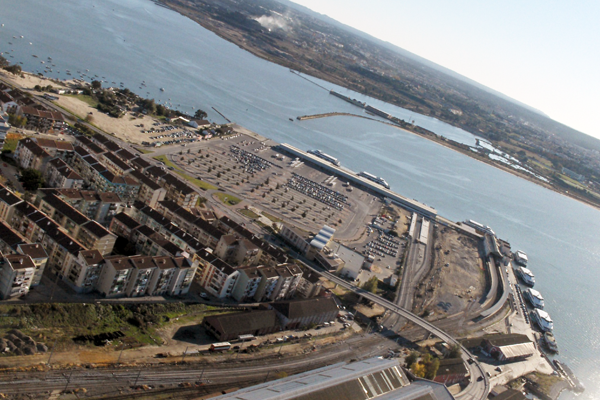
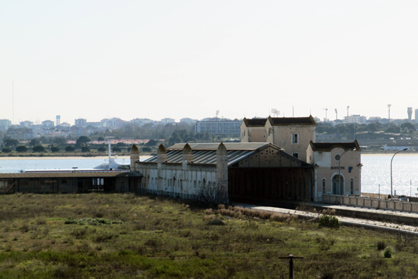
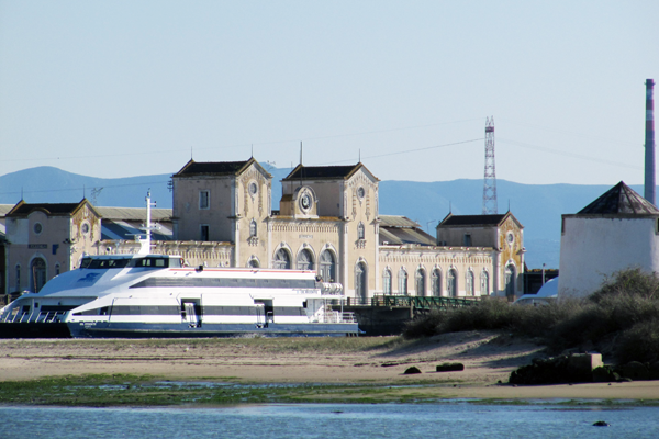
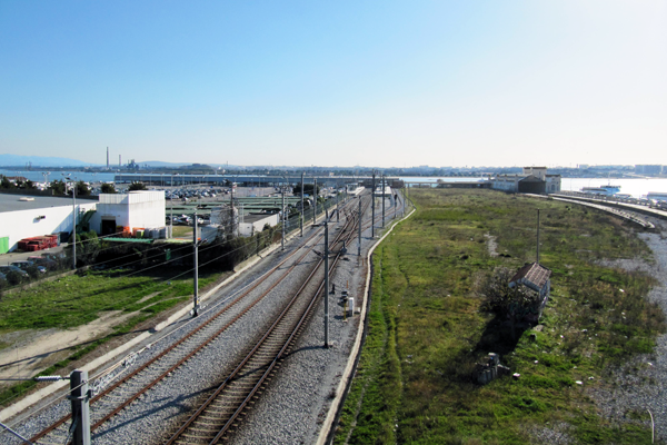
The site corresponds mainly to an embankment area over the river, currently occupied with facilities and transports infrastructures (some deactivated other still functioning but envisioning dislocation), to which it is aimed to find and develop new uses and connections. Historically bounded to the railway activity, the project site has been gradually abandoned, resulting in significant vacant spaces, with no current meaning or function for the city dynamic. Despite this, it includes an important heritage recognized in the city and people’s collective memory. In the surrounding area, the study site is solely devoted to ensuring transport connections (ferry, train, bus, car), not taking advantage of its full potential. The insertion on the Tagus estuary enhances wider connections, either to Lisbon and other metropolitan towns that should be unlocked.
Future of the site in relation to the site family and Adaptability
The opportunity is to form a new centrality area in the city, associated to the transformations of the industrial functions and to a possible new location of current transport interchange. It triggers the promotion of new experiences and activities, to the local community but also to visitors and tourists, emphasizing local values and resources, ensuring the efficiency and sustainability of solutions. The balance between heritage conservation and its “activation” to new uses, recycling built structures to new purposes with larger urban interactivity, bringing together different public and private actors. These new activities can include permanent and temporary elements, that can adapt to financial resources and that can be built autonomously depending on actors and future timings.
The riverfront location ensures a privileged landscape, proximity to sensitive natural areas and nearby recently redesigned waterfronts, including a small fishing community and river beach to be improved. The existence of obsolete and non functional spaces justifies adaptation: former transport interchange and surrounding area (project site) and deactivated railway link to Seixal. Other areas as the current transport interchange and parking area or the poorly designed road connections are also included in different scenario possibilities for the site.
The complete file gives information and suggestions based on possibilities that were considered in recent past. Competitors are surely asked to look at process at the same time as to project, by scenario-hypothesis and showing flexibility of their proposals in order to activate new urban qualities in different circumstances.
Questions à propos du site
1. Can you send us more informations about the current interchange buildings and the Sul e Sueste ? (For example, sections , elevations, plans..) Or some other photo?
The new files BARREIRO-PT-PS-SULSUESTE.pdf with drawings of the former transport interchange Sul and Sueste building and pictures BARREIRO-PT-PS-P19.jpg to BARREIRO-PT-PS-P28.jpg are now added to the competition folder (available for download in folder 0-New_Docs_After_Launch).
2. Is there already a project for the light railway path? Could you communicate us the general light railway network for the Lisbon Metropolitan Area?
See competition files BARREIRO-PT-SS-M1 and BARREIRO-PT-C-Pr, pages 12 and 15; the axis foreseen for the light rail is integrated in the channel-space of the former railway link Barreiro-Seixal.
3. Can you communicate us the actual project for the former Cuf site (container dock, economical park, etc..) ? Is the master plan of Barreiro still going on?
There is no enforceable project for that place, hence it should not be considered in the competitors' proposals. And yes, the masterplan is still going on.
4. Which is the actual use for the wagons warehouses, situated at the north east of the project site, along the avenida Republica? Is there a project of rehabilitation on these buildings?
Its use, as indicated in file BARREIRO-PT-SS-M1, is that of a warehouse and also a workshop related to rail infrastructure. There is no rehabilitation project for the referred buldings.
According to what's stated in file BARREIRO-PT-C-Pr (page 14), "The other buildings related to the rail activity, considering some of them are still being used, it is encouraged they also be kept and gave new uses for resources efficiency".
5. Which is the minimum height for the passage of the ferries below the bridge Seixal-Barreiro?
Data not available. However, it is considered that the integration of soft mobility modes seems incompatible with a proposal developed in height; competitors might consider a solution with pivoting or bending characteristics.
6. Where would go the ferry terminal in a second phase of the project? This project is going on?
This location is not yet defined, but it will be outside the competition area and not in its immediate surroundings.
7. Which is the actual use of the red warehouse between the avenida sapaderos and the railway?
See answer 4.
8. Could you give us a list of the cultural equipments existing today in Barreiro? There are associations? Sportive equipments? There are associations or club ? Could you give us a list of the educational equipments existing today in Barreiro?
Barreiro has a large number of associations, although a majority of it is rather small.
Sports facilities: the most relevant are the "Grupo Desportivo Fabril" Sports Complex, which includes a stadium and sports hall; the "Futebol Clube Barreirense" small stadium; the Municipal Sports Hall; the Municipal Pool. There are also several small-scale sports centers and sports halls integrated in schools facilities.
Schools: the existing schools correspond to the municipality needs and there is a higher education facility (university level).
Cultural facilities: the most relevant are the Municipal Auditorium Augusto Cabrita, a Municipal Library and the Quimiparque Casa da Cultura (concert hall).
As for museums and alike, there are the Reservas Museológicas of Barreiro Municipality, the Museu do Fuzileiro and the Casa Museu Alfredo da Silva.
More information in the city of Barreiro's website.
9. Have you architectural plans of the former railway station Sul SulOeste and the new railway station next to the ferry terminal or other buildings presents around the strategic site?
For drawings of the former transport interchange Sul and Sueste building see answer 1.
Regarding the other buildings, there are no available elements.
10. Would it be possible to have any plans of Sul Sueste building?
See answer 1.
11. We would like to know if there are more technical drawings related to the existing buildings, in particular the old train station. Moreover we have seen different purposes about a new bridge connecting Barreiro to Lisbon. Can we consider this option in the future development of the area?
See answer 1. There is no new bridge nor is it location definite.
12. We planned our trip before the announcement of the official site visit on May. Could we please ask whether there was any updates such as the future of the transport hub or any other plans for the future?
There are no updates to report or to what is mentioned in the competition files.
13. What should be the height of the bridge over the Coina river?
See answer 5.
14. What are or where can we find the building regulations that apply to the site?
At this stage, competitors' proposals should consider the information made available for the competition purposes; after the competition phase, when developing the project, conditions and regulations laid down in the relevant documents should be ensured.
15. Is it possible to envisage railway connections to other towns, or is the railway line completely deactivated?
The existing railway line runs from Barreiro to Praias do Sado (in Setúbal). Its expansion or connection to new lines is not expected in the future (it may even become deactivated).
18. Do we have to design a new station for the light train in the strategic area?
No.
19. About the parking is it necessary to maintain the existing one or can we change the position and rethink a new one?
Relating to the competition theme, the parking area may be adapted, at the competitors' discretion, proposing how this territory can change and adapt as/if needed.
20. Is it necessary to renovate and rethink all the boat pier? or we must rethink and design only the old part near the old Suel e Sueste station?
It's at the competitors' discretion to elaborate a proposal for that area; this proposal should contemplate on how this territory can change and adapt as/if needed.
21. Is it necessary to maintain the existing rail line near the old station? we need to upgrate it?
If the railway line to which the question refers to is the remnants of the former station, these have been removed. If it concerns the ones which are operating in Sado Line, then it's at the competitors' discretion to elaborate a proposal, in view of how this territory can change and adapt as/if needed, bearing in mind that this railway line may be deactivated in the future.
22. Are there any main functions to be included in the "deactivated railway lines"area?
On this matter see what's written in the competition files, namely page 14 in file BARREIRO-PT-C-Pr.
16. Do we have to design the line of the light train on the bridge that crosses the river Coina?
No. Relating to the competition theme "Adaptable City", the goal is to define the link Barreiro-Seixal over the river through soft mobility modes (multi-use, pedestrian and cycling), without compromising a future possibility of implementing the light rail.
17. The workers' houses on the line route of the light train should be maintained or demolished?
Relating to the competition theme, and aiming at the environmental rehabilitation of this area, proposals may consider the maintenance of the referred houses and/or its removal or conversion, considering the adaptability of the territory to future changes.
Le site est lié au thème suivant
Comment intégrer des sites vacants dans le développement urbain ? Des changements d’économie, de gouvernance ou sociétaux peuvent faire apparaître des espaces vacants dans le paysage urbain : complexes entiers de bâtiments en attente de nouveaux usagers, anciennes zones militaires, zones vertes délaissées… Ces espaces sont parfois difficiles à intégrer dans le développement urbain normal/organique car trop grands et nécessitant une adaptation totale. Où chercher les moyens de combler le vide et quand le considérer comme valeur ? Comment donner du sens à la vacance et l’intégrer dans de nouvelles façons de faire la ville ?
Questions à propos du site
Pour pouvoir poser une question, vous devez être connecté (et, par conséquent, inscrit au concours).
Ve. 16 mai 2025
Date limite de soumission des questions
Ve. 30 mai 2025
Date limite de réponses aux questions
Avant de soumettre votre question, assurez-vous qu'elle n'apparaît pas déjà dans la FAQ.
Merci de poser vos questions sur les sites dans le menu Sites.
Merci de poser vos questions sur le règlement dans le menu Règlement.
Si votre question ne reçoit pas de réponse dans les 10 jours, merci de vérifier qu'elle ne figure pas dans la FAQ sous un autre intitulé ; sinon, contactez le secrétariat concerné par email (secrétariats nationaux pour les sites, secrétariat européen pour le règlement.)