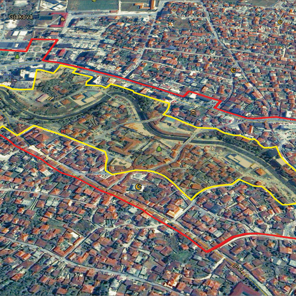
Gjakova
Les Dossiers synthétiques et d'enjeux sont disponibles gratuitement.
Merci de vous inscrire et vous connecter pour accéder au Dossier complet de site.
- Dossier synthétique EN
- Le site sur Google Maps
- Retour à la carte
Données synthétiques
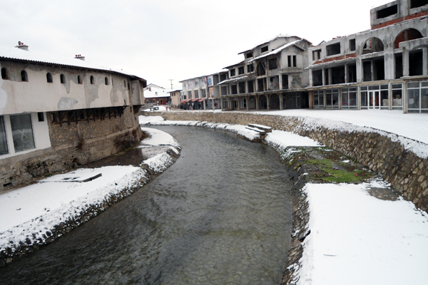
E13-KO-Gjakova-Cover
Category Urban - architectural
Location Gjakova, Kosovo
Population City 96,000 inhab.
Strategic site 40 ha - Project site 7 ha
Site proposed by Municipality
Owner(s) of the site City of Gjakova
Commision after competition Urban project management role, design of public and landscape areas. Revitalizing of the riverbank and transformation of central public zone. Reconnecting the area to city center
Team representative professional of urban design – architect
Information complémentaire
How can the site contribute to the adaptable city?
Gjakova is a city with great cultural heritage, historical and natural wealth, the city of rivers, as a center of developed industry and agriculture. Gjakova as free economical zone plays a very important role in economic development. Beside industry the city is a home of the public University which is a great generator for city’s diversity. The area of Dukagjin, where Gjakova plays a central role is on the of most visited touristic areas, providing amazing nature, architectural heritage from different time periods and variety of craft production. The site which is located in the central part of the city will revive and connect the existing urban block with the rest of the city by improving space and adding functions to it through adaptation. The river bank should be the added value of the city core.
City strategy
City strategy for the future is to develop Industry, trade and food industry in particular. Cultural heritage of the city serves as a great promoter of tourism, and Gjakova is known for its hospitality. The municipality has developed several visions for the city development and each of them involves industry and trade. City’s politics is to decentralize the government and to distribute the level of investment and development, for the city not to be over built or concentrated. In terms of internationality, Gjakova plays an important role since it is situated near Albanian border, and connected with main axis with Peja and Prishtina. As a touristic city a nd heritage promoter the city center which is filled with history needs an improved incorporated space that makes Gjakova as a whole.
Site definition
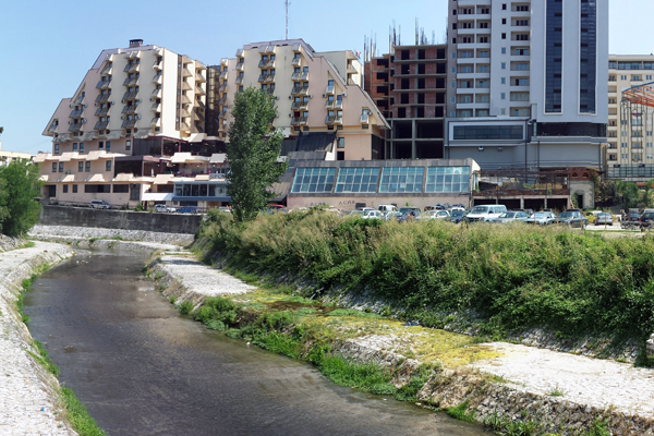
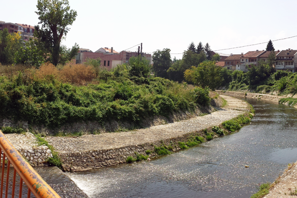
The site has a central role in the city and is located along the river Krena, passing through the historic part of Gjakova. From north where the city park is located and Hotel Pashtrik as a landmark, the site stretches along the river down to south, crossing near old commercial areas, religious buildings, residential areas and newly developed commercial zones.
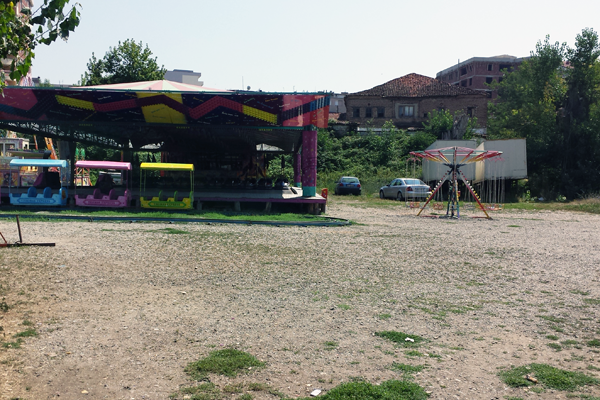
Beside the riverbank which has no activities, on the north of intervention area there is a big public space near hotel, music school, museum, commercial and residential area. Four bridges connect both sides of the riverbank only physically because there is a lack of function and activity that will connect this part to the rest of dynamic city center.
Future of the site in relation to the site family and to Adaptability
The city of Gjakova is layered in these categories: Cultural, religious, social and industrial context. As an early developed city the center plays a connecting role to other areas of the city. Diversity is the element that characterizes the Gjakova, especially in the sense of everyday life and tourism, where crafts take an important role of city image and its role in national level, as a factor of culture, economy and heritage.
Religious diversity is one of the Gjakova’s attributes. Traces of old ottoman bazaars still can be found in the city as well as contemporary architecture that compliments the variety of it.
Low rise buildings still continue the tradition of commercial use and are spread all around the city, usually combined with residential floors above stores and other craftsman shops. The river is the element that gives Gjakova the charm and it should play a main role in connecting the city not separating it by creating gap as it is. The riverbank should be functionalized and generate new improved public space and why not multifunctional space, which is the key attribute of all urban blocks of the city.
Questions à propos du site
It seems there is an error with the dxf file, because we can't open it in AutoCAD2012. Could you please provide a new file?
There is a new file uploaded on folder : "0- New docs after launch". If there are problems opening it, contact us immediately.
What information should the panels cointain? Is it required to submit specific drawings with specific scales on each panel? For instance, should the first panel contain information regarding the strategic site and the second regarding the project site? Or is it free choice?
Presentation is your choice. Either you choose to present first the strategic site and then zoom into project site. Panels should contain the information required to present your proposal, they way you organize the information is your choice.
The report of the visit on 26th May talks about "buildings that will be preserved… Buildings were marked on their maps". Is it possible to know these buildings?
Cultural Heritage map is available in folder Additional_docs_on_web Folder and contains buildings that will be preserved. These buildings are also marked on the main map.
What is Tabhanet?
Tabakhanet (Tanner) - are craftsman shops where people used to work with leather.
Usually they were near water flow (river) because water was used to remove leathers scent.
What is the building cross the river to the right hand, near the ethnographic museum? Is it empty,can we use it,can we demolish it?
The building you are referring to is part of the urban block. If the proposal to demolish it contribiutes highly into the project than it can be proposed. But it needs to be clearly analyzed and argumented such intervention. If the answer is not clear you can contact Europan Kosovo directly with specific marking of the building.
It is possible to have some other pictures of the place near the river?
Please check folder "Additional docs on web" / "Pictures from Site - River" to find several pictures.
Is there already a planned bike path in the city?
Bikes are used a lot in the city by citizens but planned bike paths are missing. You can propose these paths in the area of intervention.
Are there any residence fpr students in the city or neighborhoods where they use to live?
Student housing were built in the '80 and they are located next to "Fehmi Agani University" on the East Side of the city. In the end of Mbreteresha Teute street.
The site visit report talks about a Q&A session. Could you give a public report of those informations?
Site visit report contains as well Q&A in the end of the document. Those were details that were relevant for general use and related to the competition.
The site viste report talks about the topic of private and public ownership of the building next to the river. Is it possible to know which buildings are public and which are private?
Only buidings that are public in the project site next to the river are: Music School, Red Cross Building, First Albanian School, Kelmend Rizvanolli School (Tefik Qanga Street).
The "Quendra Kryesore e Mjekesis familjare" is it only composed of the U-shaped building or there are other buildings in the surrounding area that are part of the complex?
"Qendra Kryesore e Mjekesise Familjare" is Health Care Center. Only the building next to the monument (in map you can see it as a white structure), north from the left wing of the U-shaped building, can be considered for demoliton. The rest are structrures that will remain.
Is there any specific requirements for programatic needs (architectural and/or urban) to be incorporated on the site?
The main goal of the project is to make the connectivity of the river with the city. All elements can be used to reach this goal. It is up to the designer to decide which elements to incorporate so this connectivity is achieved.
Could you provide topographic information in a dwg file? Or cross sections of the riverbank? Also could it be possible to have a dwg file of the Strategic Site or even the entire city?
Site survey now is online and you can download it in the folder New_docs_after_launch
Is it possible to have pictures to all the bridges that cross the river inside the project area?
Pictures of the location as well as the map of where the pictures were taken are in the main folder of documentation. You can find brigde pictures there.
What happens when the river has the high tide? Do we have to live the track beside the river empty? Or can we use it?
The river has its own security levels for flooding. Water amount in the river is not that big. There can be a creative proposal to use this area for recreational purposes.
Le site est lié au thème suivant
Comment transformer des obstacles physiques en nouvelles connexions ? Il s’agit de créer des « ponts » comme des connections linéaires entre différents contextes, surplombant une obstacle qui peut être une rivière, un chemin de fer ou d’autres barrières physiques. Parfois cependant, il est possible de transformer l’obstacle afin qu’il devienne producteur de mouvements dans différents sens et directions, passant alors de barrière de séparation en élément connecteur. L’obstacle peut être habité, coupé, entrecroisé ; il peut être l’opportunité d’augmenter la densité, de changer les fonctions des entités divisées ou encore apporter une nouvelle perspective à un contexte familier.
Questions à propos du site
Pour pouvoir poser une question, vous devez être connecté (et, par conséquent, inscrit au concours).
Ve. 16 mai 2025
Date limite de soumission des questions
Ve. 30 mai 2025
Date limite de réponses aux questions
Avant de soumettre votre question, assurez-vous qu'elle n'apparaît pas déjà dans la FAQ.
Merci de poser vos questions sur les sites dans le menu Sites.
Merci de poser vos questions sur le règlement dans le menu Règlement.
Si votre question ne reçoit pas de réponse dans les 10 jours, merci de vérifier qu'elle ne figure pas dans la FAQ sous un autre intitulé ; sinon, contactez le secrétariat concerné par email (secrétariats nationaux pour les sites, secrétariat européen pour le règlement.)