Ingolstadt
Les Dossiers synthétiques et d'enjeux sont disponibles gratuitement.
Merci de vous inscrire et vous connecter pour accéder au Dossier complet de site.
- Dossier synthétique DE | EN
- Le site sur Google Maps
- Retour à la carte
Données synthétiques
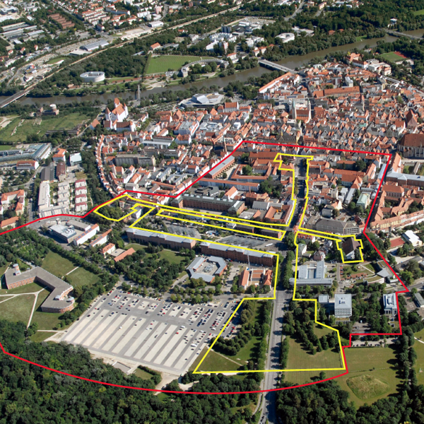
E13-DE-Ingolstadt-Cover
Category Urban – landscape – architectural – traffic – sociology
Location Town centre North
Population c. 130,000 inhab.
Strategic site c. 42ha - Project site 6.4 ha
Site proposed by City of Ingolstadt
Owner(s) of the site City of Ingolstadt, Free State of Bavaria
Commision after competition Urban masterplan/preliminary design study
Team representative professional of urban design – architecture – landscape architecture
Information complémentaire
How can the site contribute to the adaptable city?
The priority goal is to strengthen the old town in a sustainable and resource-saving manner. Viable solutions must be found to questions regarding mobility, frequency, the public interest and sustainability in the sense of creativity, health and well-being, in order to prevent monostructures and trading-down effects. A concept is called for that engages the different protagonists from all social and age groups in the use of space, creates an identity for the locality and permits a mixture of uses according to needs. The old town must be developed as a historically significant urban space, creating an adaptable living environment that adapts to ever-changing parameters.
City strategy
Ingolstadt is striving for the urban planning model of a compact city based on historic factors, natural conditions and the traffic situation. With all its diversity, the historic old town is the heart and cultural centre of Ingolstadt. The city’s identity and experience value are to be enhanced with the goal of inner development, the role of Ingolstadt consolidated as a regional centre and land used in the most efficient way possible as a precious resource. Consolidating the centre of Ingolstadt as a residential location also means creating an attractive environment, qualifying the public sphere and establishing community-oriented uses with a cultural focus.
Site definition
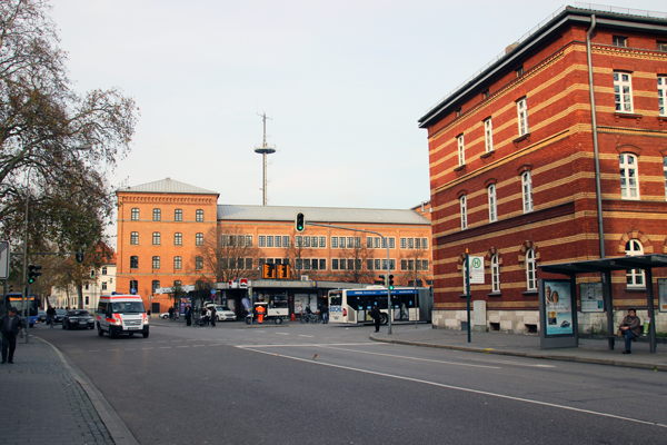
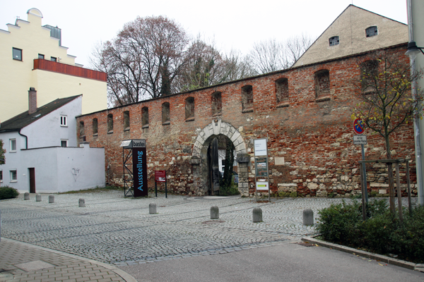
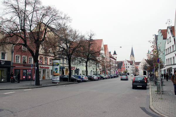
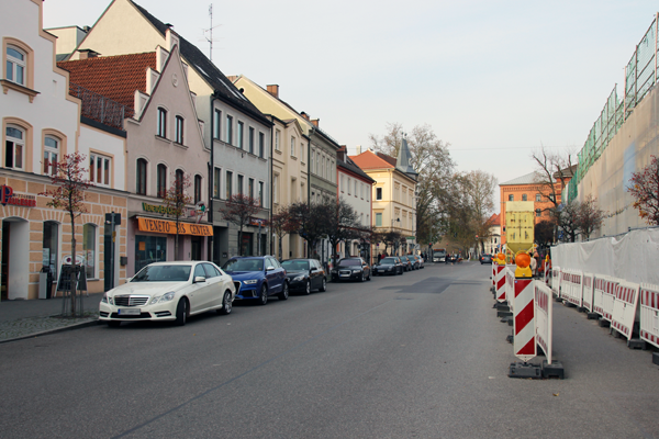
The planning area is located in the centre of Ingolstadt and marks the northern entrance to the historic old town. The study area embraces the northern old town along Harderstrasse and the intersection of Oberer Graben from the Harderbastei to the central bus station (ZOB) and Wunderlkasematte on Unterer Graben. This old town district is characterised by continuous block perimeter building with predominantly gable-ended, two- to three-storey buildings. The small-scale mediaeval building structure is interrupted by in part large-scale preserved military structures such as Harderbastei and Wunderlkasematte that were erected in the 14th century.
Future of the site in relation to the site family and Adaptability
Harderstrasse, an important entrance to the historic core, is exhibiting the first signs of trading-down, the effects of which must be countered. Harderstrasse serves as a traffic access to the old town at the expense of a pedestrianized, atmospheric street space. The priority task will be to reconfigure the streets as a living environment for all residents, and thus develop a networked mobility concept that prevents or breaks down barriers. Since the population is constantly changing in terms of numbers and structure, new demands must be integrated and the appropriate approach taken to the design of public space that satisfies changing demands. In addition to the preparation of creative mobility and a design concept for the public sphere of Harderstrasse, a thematic cross-link must be created in the Unterer/Oberer Graben area for the Harderbastei and Wunderlkasematte as historic monuments across the site of the central bus station. A concept is called for that permits different protagonists from all social and age groups to participate in the use of space, creates an identity for the location and permits a mixture of uses to meet demands, thus developing its own power and dynamism. Besides the wish for upgrading the streetscape, the goal should be to establish community-oriented uses with a cultural focus and to exploit existing neighbourhood potential for the purposes of sustainable urban development according to the motto “Ingolstadt – liveable in 2025”.
Questions à propos du site
Can you upload a DWG of the whole city? At least the whole old town is necesary.
The map INGOLSTADT-DE-C-M2.dwg is available in the folder "0-New_docs_after_launch".
The ZOB site til the Proviantstr. does not fit in a 1:500 scale in the A1 panel. Can I use another graphic scale between 1:500 and 1:1000?
If it is not possible to display your project for the ZOB in 1:500 you are free to chose 1:1.000.
Can we change the location of Central Bus Station (ZOB) or is it possible to reorganize the whole area in design and frequency of incoming and outgoing traffic? Can we change the traffic-garden-services zone distribution and existing architectures?
The Nordbahnhof (Northern station), situated close to the old town and outside of the old-town ring is a bus station as well and could be expanded. In this way at least a reduction of the number of bus routes is possible. In principle the central station must be maintained at this place. The ZOB is an important connecting station for students and provides public for the inner city. A modification or a new development are imaginable in principle, given that a convincing creative and programmatic master plan is proposed.
In case of a complete new development, solutions are in demand, that contain long-term strategies able to react to continuous changes and durable growth, formulating a strategy for a gradual and processual development.
Can we remove or reuse the bus marquees?
Yes.
Can we pedestrianize Hardertrasse from the Central Bus Station (ZOB) to Le Cafe?
Harderstrasse is an element of a traffic concept from the seventies, thus of great importance for the accessibility of the old town. The competition task calls for new mobility concepts, including the reduction of the traffic volume. A dislocation of traffic, in particular the private transport, is conceivable. Delivery and access to the old town must be guaranteed.
Can we remove the two secondary structures of the Central Bus Station? Or do we have to adapt them?
The secondary structures/annexes are dispensable and may be demolished.
Can we remove the added buildings of Harder-bastei?
The added buildings are not listed and may be removed.
Is the entire building of Harder-bastei in use?
The ground floor is entirely used for a large show room and small workshops for artists. The gabled roof, nowadays component of the listed monument, is not a part of the original bastion and was errected in the 19th century. The attic, previously used as storage space, has never been restored and is empty inter alia due to its poor accessibility.
Can we modify the interior of Harder-bastei?
While preserving the ancient protected structure of the building, changes for instance in the form of reversible constructions are possible. When using the attic storey or other annexes a new acces concept is mandatory. Modifications of the in some extend meters thick walls and ceilings of the former town gate must be reduced to a minimum.
Do we have to modify the interior of Le Cafe?
No. Desired is a concept for the exterior gastronomic area including its potentials in the course of a rearrangement of the public street space.
Can we find the plans of Le Cafe in any site?
No.
Which kind of uses can we find today in Ziegel-bastei?
To date only the eastern wing of the derelict former renaissance fortification was carefully integrated in a new building development and prepared for new uses. Today the ground floor and the first floor serve as storage space of the town archive. The second floor with its office premises is temporarily used by the administration of the Medizinhistorisches Museum (museum of medical history). Concerning the rest of the preserved parts of the former bastion: Foundation and vault of the western wing and the ancient powder magazine and storage leg, which open up to the yard, are only provisionally secured. These parts of the bastion cannot be used without structural enhancement.
Le site est lié au thème suivant
Comment transformer des obstacles physiques en nouvelles connexions ?
Il s’agit de créer des « ponts » comme des connections linéaires entre différents contextes, surplombant une obstacle qui peut être une rivière, un chemin de fer ou d’autres barrières physiques. Parfois cependant, il est possible de transformer l’obstacle afin qu’il devienne producteur de mouvements dans différents sens et directions, passant alors de barrière de séparation en élément connecteur. L’obstacle peut être habité, coupé, entrecroisé ; il peut être l’opportunité d’augmenter la densité, de changer les fonctions des entités divisées ou encore apporter une nouvelle perspective à un contexte familier.
Questions à propos du site
Pour pouvoir poser une question, vous devez être connecté (et, par conséquent, inscrit au concours).
Ve. 16 mai 2025
Date limite de soumission des questions
Ve. 30 mai 2025
Date limite de réponses aux questions
Avant de soumettre votre question, assurez-vous qu'elle n'apparaît pas déjà dans la FAQ.
Merci de poser vos questions sur les sites dans le menu Sites.
Merci de poser vos questions sur le règlement dans le menu Règlement.
Si votre question ne reçoit pas de réponse dans les 10 jours, merci de vérifier qu'elle ne figure pas dans la FAQ sous un autre intitulé ; sinon, contactez le secrétariat concerné par email (secrétariats nationaux pour les sites, secrétariat européen pour le règlement.)