Alta (NO)
Les Dossiers synthétiques et d'enjeux sont disponibles gratuitement.
Merci de vous inscrire et vous connecter pour accéder au Dossier complet de site.
- Dossier synthétique EN
- Dossier d’enjeux EN
- Le site sur Google Maps
- Retour à la carte
Données synthétiques
Échelle de projet L - urbain & architectural
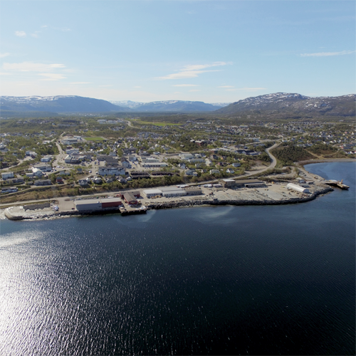
Localisation Bossekop, Alta
Population 20.000 hab.
Site stratégique 36 ha – Site de projet 9 ha
Site proposé par Municipality of Alta
Acteurs impliqués Municipality of Alta
Propriétaire du site Alta Skiferlag AS, Municipality of Alta
Phase post concours Planning Commission
Représentant d'équipe architecte, urbaniste, paysagiste
Information complémentaire
How can the site contribute to the productive city?
Local slate producers is currently in the process of relocating the operations at ‘Skiferkaia’, an industrial area. This opens for a new understanding and use of this site. The municipality needs a masterplan and a vision for a multifunctional, urban and productive seafront that connects to the local center of Bossekop, and Alta at large. This includes plans for housing, student housing, culture activities and facilities for sustainable production. A fundamental guiding principle is that the plan should become a part of the productive development of Alta and the region, underpinning the Alta identity; culturally mixed, young and entrepreneurial. The existing buildings at Skiferkaia can inherit new productive activities that for instance evolves around the start-ups in the construction segment; Alta has a pro-active construction industry both in terms of digital and manual innovation. Production at Skiferkaia could also involve crossing the edge of the quay - exploring sustainable aquaculture.
City strategy
Alta is a growing city and much of the explanation is Alta’s multicultural and entrepreneurial DNA. Its young population mixed with rapid changes of commercial opportunities in the North suggests a new and interesting story to emerge. At the same time, the sprawling urban structure of Alta is a challenging starting point for a sustainable development. The three, often competing centers of Alta and how they can form a sustainable model for Alta’s growth is the urban backdrop for the competition. The strategy of the municipality has been to develop each local center with its particularities. The renewal of Bossekop will soon be undertaken and Skiferkaia plays a key role in the area planning. As Bossekop is the only local center with access to the sea, it’s emphasized to connect the local center with the seafront. The municipality finds it important to explore how historical and landscape qualities can be reinterpreted to add a new dimension to Alta and, moreover, how local resources, existing buildings and local actors can be included in a development.
Site definition
The areas along the seafront are mostly used for storing and shipping slate, and almost every building on the site functions as production and administration facilities for the slate industry. In the future these areas and buildings will be available for transformation. Only the hardware shop, Felleskjøpet, will remain after the relocation process. The ground in the Europan site is constructed quay except a patch of ground in the north-east which is natural shoreline/beach. Part of the Project Site is the sloping terrain which today consists of baracks of student housing and a former bakery. These buildings are planned to be demolished and replaced by a new student housing complex mediating the link between the shorefront and the plateau of the local center Bossekop.
How is Production Considered in the Urban Diversity Program?
Alta is something out of the ordinary. In contrast to other places in its region, it claims to have ‘no need of public jobs’, it has managed to establish the region’s strongest business environment. The city is highly entrepreneurial and pro-active. The city has its origins in aquaculture, agriculture, and the slate industry, which successfully has been developed and represents an important side of Alta’s production today. For decades, the city has been the regional center for contractors and construction businesses. Within the construction business Alta is known for its competence and innovation, this is evident in the late tendencies of comprehensive implementation of new technology in construction processes. The city has also put forward a new focus a on tourism as Alta is a desired destination for outdoor activities and nature experiences. As such, many things happen in Alta. It has the doers, but it needs a convincing vision from a smart team of architects and landscape architects to make urban synergies happen at the Europan site.
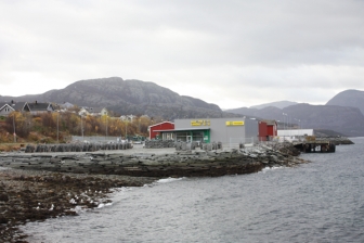 Natural shoreline, sloping terrain and the Felleskjøpet hardware store
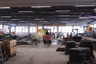 Production activities inside Strandveien 48
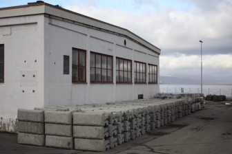 Strandveien 48
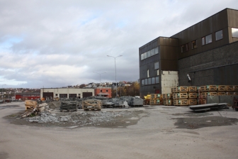 Strandveien 60
Questions à propos du site
Is there a 3D-model available of the project area?
Yes, there is a 3D-model available when you have registered and payed the participation fee. The 3D-model of the project site can be found in the folder Project Site (PS) / NO-Alta-PS-M1.dwg
How many cars cross 'Strandveien' road throughout the day? Is the traffic heavier along this road or along the ones that cross the city?
Average annual daily traffic 2016 (AADT) is:
- E6 Bossekop: 11,959
- Strandveien: 623
You can find information and data (in Norwegian) on traffic on the map service of the Norwegian Public Roads Administartion (Statens Vegvesen)
Do the proposals need to take into account the new residential area that is located in the Study Area?
Competitors are asked to show new connections within the Study Area. Integrating the new residential area is part of that.
Is there a clear time frame for the dismission of the slate factory? Is there a phasing for the project?
The specific strategy and timeframe has not been decided upon yet, the process of relocating the operations connected to the slate industry at Skiferkaia is in its initial phase. In a rough estimate, this process might take up to ten years – however, parts of the area at ‘Skiferkaia’ is currently ready to be transformed.
Is it possibile to provide any documents of the guidelines focus on the improvement of the public space and mobility of Bossekop (as mentioned at p.13 in the Competition Brief).
The reports made in the feasibility study has worked as basis to the development of the zoning plan in Bossekop, as inspiration and as concrete guidelines. The guidelines that has been adopted to zoning of Bossekop is listed below:
- The Bossekop junction will be improved with a roundabout, combined with a lowering of Bossekopbakken and an ‘environmental platform’ established to ensure a plan-free crossing at the school.
- E6 / Altaveien through Bossekop will be established as a green street (miljøgate), with a narrowed lane, elevated pedestrian crossings and with a green buffer zone between lane and pedestrian and cycle path.
- It is necessary to plan for sidewalks along Skiferveien, Sorenskriverveien, Thomasbakkeveien and Strandveien to ensure good connections for pedestrians and cyclists.
- Area use (Arealformål) in Bossekop local center must be more closely combined business/ residential, with business on the ground floor and housing above.
- The quarters of the local center will be extended and aligned to the surrounding roads to give the center area a defined expression. This applies especially to the Altaveien/ Skiferveien, Skiferveien/Sorenskriverveien and Sorenskriverveien/ Bossekopveien crossings, where there are currently large asphalt surfaces. This must be especially assessed in connection with ongoing projects.
- Access to the sea through the facilitation of the coastal promenade towards Hjemmeluft and Bossekopberget will be secured, connected with Bosseko local center through the suggested axes.
- The Bossekop shoreline will be secured as an accessible public area, with a beach and shared functions.
- Skiferkaia / the slate company’s area along Strandveien are set for future transformation with requirements for detailed regulation. The area will contain a mix of features that, among other things, are more public-oriented, which will give Bossekop center and Alta a more urban contact with the sea. The content of the area and how the area is divided is determined by the Europan competition and the regulation process.
- Parking space in basements of new buildings are required.
-
An area designated for facilitating public parking for businesses is to be set of.
-
It will be catered for good, car-free public areas in the city center, such as parks with playgrounds, squares.
-
A design manual for the Bossekop Center is prepared, which deals with materials use and color use for the building and furnishing outdoor spaces.
Is it possibile to receive the whole CAD-file of the conurbation?
Unfortunately, it is not possible. The map service used in Alta is a collaboration/ business model that deprives the geodata authority to deliver a CAD-file of the whole conurbation to the competition. The municipal map in the ‘Conurbation’-folder (NO-Alta-C-M1.pdf) is vectorized, and a solution could be to convert this file to CAD.
Does the competitors need to consider the new proposed road and the new developments found on webpage of Alta Municipality? What is the target of the planned road?
Yes, information concerning the new road is to be found in the 'New Docs After Launch'-folder. The road is connected to developement of the planned residential area located south of the project site.
Is it possible to provide the dwg-file of the new residential area by the Komsa Top? (p.15 in the Competition Brief)
Unfortunately, that is not possible.
Is it possible to have information about the depths of the sea in the area close to Skiferkaia?
Yes, you can follow this link underneath to the map service of the Norwegian Coastal Administration. You can search for 'Alta, Skiferkaia', and then hit the button for "Temakart" (theme maps) you will find the informastion you need in "Marine grunndata". This information is also described in the Site Visit Report.
What data can be provided on wind directions and annual wind intensity around Skiferkaia? This question concerns the possible involvement of wind power production at the project site.
Unfortunately, there are no site-specific wind measures available. But, the webpage of the Norwegian Meterological Institute can provide you with data on average wind measures and wind directions on the observation site is situated at Alta Airport. This data gives an indication for possibilities.
Is it possible to get a map showing the routes of the bus in Bossekop?
A map showing the bus routes in Bossekop is to be found in the folder 'New Docs After Launch'-folder.
Is it possible to get information about the composition for the ground? This is interesting in order to know what can grow there.
The ground at Skiferkaia consists of slate (mainly) and other unknown filling material. The rocky ground and the harsh climate at the project site /study area limits the conditions for vegetation. Suggestions to meet this challenge are welcomed.
What is the property structure of the sites at Strandveien 48 and 60? Are these sites privately owned by Skiferlaget, or do the company currently rent the site from the municipality of Alta?
Alta municipality owns the ground and ‘Skiferlaget’ has a leasing agreement on these areas. The buildings are owned by the Skiferlaget.
Is the new location where Skiferkaia is going to move the procession of slate already known? If so, is this information accessible to Europan participants? Can that be addressed in the project proposal?
The new location of the production facilities has not yet been decided upon, but there are two options that are being evaluated: Peska (in ‘Skiferberget’) or Skillemo Industrial Area.
Is it possible to get drawings of the building Strandveien 40, the workshop building of Felleskjøpet? Is it possible to receive any of the plans of Strandveien 48, 60 and 40 in CAD?
Unfortunately, there are no CAD-drawings of the buildings available. Drawings of Strandveien 40 has not been possible to get hold of.
Agriculture; what types of cultivation exists in Alta, and what are the species? What are the main types of agriculture, and is this production for local market, or export?
Documents on both agriculture and forestry in Alta is to be found in the 'New Docs After Launch'-folder. As the documents are written in Norwegian, it is suggested to copy the text to Google Translate. The main type of agriculture in Alta is milk production. Most of the milk is distributed to stores in Alta, the rest is distributed within the Northern region.
Which are the species of plants present on the shoreline of Alta area? Can you please give information about it or suggest a source where to find them?
The most common species on the shoreline in the Alta area is: birch (mountain birch, dwarf birch), pine, goat willow, vier, aspen, bird cherry and grey alder. Other vegetation: moss, lingonberries, blueberries, blackberry, common heather/ ling, chives, bunchberry, coltsfoot, oxeye daisy, mushrooms and lichen. More information about the vegetation can be found on the webpage of the Norwegian Environment Agency here.
Agriculture; is there a demand for local agricultural production in the commercial market? Are there any local organizations of farmers that arrange market places, seminars and other events? Are the farmers currently facing any issues? Is there a need of common facilities - such as warehouses, greenhouses or workshops? Is it usual to grow vegetables in greenhouses?
There is a growing interest for local food production in Alta, and several initiatives can exemplify this tendency: ‘Monica and Ingers Gårdsmat’ a sheep farmer that produces meat for sale to order. ‘Trasti og Trine’ has café and a market place with local products, situated 10 km from the center of Alta. ‘Nordlysmat’ is a company that produces food from an uncultivated farm. In addition, some local farmers have outlets directly from the farm, selling i.e. potatoes. In one of the grocery stores in Alta there is a counter prepared for local food, other than that - there are no bigger market place, or seminars, dedicated to this topic. Currently, greenhouses are not used on a scale of relevance to production.
Le site est lié au thème suivant
D'une zone productive à la ville productive Quel type d’urbanité pour les zones logistiques et industrielles ? La ville contemporaine est marquée par un urbanisme de grandes surfaces actives et reliées aux réseaux métropolitains, et d’industries plus légères en périphérie des centres-villes. Tous deux fonctionnent en autarcie par rapport aux zones adjacentes à usages monorythmiques.
Quel type d’urbanité pour les zones logistiques et industrielles ?
Le défi sera d’injecter de nouvelles économies potentiellement génératrices de synergies entre les usages, mais aussi de porosités, donnant vie à un milieu urbain polyrythmique. Comment donc développer des espaces communs partageables entre des usagers d’activités différentes et avec les habitants des zones alentour ?
Documents spécifiques
Skiferkaia Alta Kommune
Questions à propos du site
Pour pouvoir poser une question, vous devez être connecté (et, par conséquent, inscrit au concours).
Ve. 16 mai 2025
Date limite de soumission des questions
Ve. 30 mai 2025
Date limite de réponses aux questions
Avant de soumettre votre question, assurez-vous qu'elle n'apparaît pas déjà dans la FAQ.
Merci de poser vos questions sur les sites dans le menu Sites.
Merci de poser vos questions sur le règlement dans le menu Règlement.
Si votre question ne reçoit pas de réponse dans les 10 jours, merci de vérifier qu'elle ne figure pas dans la FAQ sous un autre intitulé ; sinon, contactez le secrétariat concerné par email (secrétariats nationaux pour les sites, secrétariat européen pour le règlement.)