Karlskrona (SE)
Les Dossiers synthétiques et d'enjeux sont disponibles gratuitement.
Merci de vous inscrire et vous connecter pour accéder au Dossier complet de site.
- Dossier synthétique EN
- Dossier d’enjeux EN
- Le site sur Google Maps
- Retour à la carte
Données synthétiques

Échelles de projet L/S - urbain & architectural
Localisation Karlskrona, Hattholmen
Population 65.380 hab.
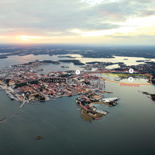
Site stratégique 53 ha (27 ha d'eau)
Site de projet 32 ha (20 ha d'eau)
Site proposé par Municipalité de Karlskrona
Acteurs impliqués Municipalité de Karlskrona
Propriétaire du site Municipalité de Karlskrona
Phase post concours Dévelopement d'un programme et études urbaines en collaboration avec la Municipalité de Karlskrona
Représentant d'équipe architecte, urbaniste, paysagiste
Information complémentaire
How can the site contribute to the productive city?
Founded and built right in the archipelago, as the naval base of Sweden, Karlskrona has generated an urban settlement structure that is unique in the Swedish context. In part due to this history, Karlskrona as a whole has been designated a UNESCO world heritage site. This distinct way of living in, rather than by the sea offers quality of life worth conserving and capitalizing on. Later economic and related urban paradigms have made this connection less obvious.
Nowhere else is this more clear than at the land entrance to the historical city. The main, formal entrance route was from the sea in the south, at the southern end of the city's north south axis.
City strategy
The northern connection to the mainland was traditionally the back door; to some extent simply a supply route. Today, this is the most important route for arriving in the city but this is not reflected clearly in the urban structure.
The arrival of the railroad meant some part of the connection to the sea was lost, and post-war, car centred planning and industrial paradigms effectively broke this connection on much of the northern facing parts of the (old) city. Land reclaimed along the previous shoreline and between islets was used to house modern infrastructure and industry.
These lost shorelines must now be adapted to the demands of inhabitants and an evolving economy. Recreating, reinterpreting "living in the sea » in this new context is the task of the coming decades.
Site definition
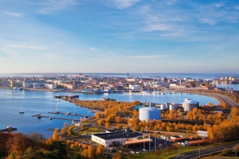
Centrally located right on the main access route to Karlskrona, Hattholmen is the site of a disused oil harbour. The city centre, the main transport node, recreational areas and the Blekinge Institute of Technology all lie within walking distance. To the north of the site is a hill and green area and at its base, an old brewery. To the south and west are harbour basins currently used as docks for pleasure craft and a canal boat, reused as student housing. Hattholmen is a low lying, fairly flat site, surrounded by more hilly terrain. Urban planning patterns shift from a faithfully implemented 18th plan on Trossö to 19th century and 20th century paradigms further north. Hattholmen is bordered by all these and is itself of a 20th century zoning scheme.
How is Production Considered in the Urban Diversity Program?
Recreating, reinterpreting "the city in the sea" in this new context is the task of the coming decades. This will require a redesign of the land, sea and their shared boundary. Contestants at Hattholmen are asked to propose answers to a number of questions. How are these reclaimed, modified shorelines to be used to meet the cities' stated identity?
In order to meet demands for housing, a number of units are to be built on the site and the existing visitors marina will be expanded within the project site, but what productive uses could be located along the shoreline?
And in what way is the meeting with the water mediated physically? Designing the shape, profile and materiality of the shoreline are all issues to be resolved.
The surrounding area is very diverse. The historical city on Trossö, the water, a green hill, an urban ex-clave (Pantarholmen) and a park are all close. The site, on the other hand, is cut off from its surroundings. Integrating Hattholmen with its surroundings, making it part of an extended urban fabric is seen as the way forward a successful redevelopment of the site.
 The city Marina, Hattholmen in background
 Marine museum, Stumholmen from Bryggareberget
 Stortorget (Main square)
Questions à propos du site
Can the existing buildings in the strategic area and in the project area be demolished?
- Project site: The project site is basically empty, but "all" buildings can be demolished.
- Strategic site: The properties within the strategic site have different land leases stretching +10 years in the future and can not be demolished within this time span. However, in the long time perspective, this area will be transformed. What the municipality is looking for is a long term strategy and an over all structure for the future. The strategic site is expected to contain mainly housing in the future.
Which scale of detail should be the design of the strategic site?
Proposals should show the street network, building volumes (footprints and heights), public buildings and spaces. This is essential for showing how the project- and strategic site is integrated in the urban fabric and with each other.
Illustration of particular urban spaces, programming of the buildings etc. is not needed for Muddret.
See page 18 of the program for compulsory material to be included in the proposals.
Is it possible to demolish the petrol station?
The petrol station can be demolished. If not, then it should be given a smaller footprint. The fuction could be useful for the city marina as well.
Is it possible to split the touristic harbour in smaller ports?
Yes, within reason.
Is the cycling path above the sea (with its drawbridge) part of the mandatory requests or just a vision suggested?
It is not mandatory but the municipality believes another connection at this end of Hattholmen to Skeppsbrokajen (Trossö) is important to integrate Hattholmen in the urban fabric.
Creating this connection is also important for generating a more interconnected bicycle and pedestrian network on the scale of the city.
In the brief is written that the marina's basins and docks should be located east and/or south. Is this mandatory or can we move these functions elsewhere?
It is mandatory to have the marina within the limits of the site. A marina must fulfil a lot of requirements regarding deapth, currents etc. and the site does fulfil these requirements.
Should we consider the existing road junction? otherwise, there are special instructions for a new road junction?
The answer to this question is to be found in the program.
Le site est lié au thème suivant
Et productif à nouveau ! Comment réintroduire l’économie productive dans les nouveaux quartiers urbains ? De nombreuses anciennes aires industrielles dans et autour des villes sont vacantes. Les bâtiments sont abandonnés, les activités se sont déplacées ou arrêtées, et les sites sont aujourd’hui des friches industrielles. L’obsolescence est le dénominateur commun de ces sites, et leur avenir est incertain. Mais on rêve de les voir éclore en nouveaux quartiers urbains vivants. Et pour éviter la gentrification opérée dans de nombreux projets de renouvellement urbain ces dernières années, ne faudrait-il pas réintroduire sur ces sites… des activités productives ? Parce que ces lieux furent jadis industriels et reliés à la ville. Et parce qu’on veut une ville réellement mixte, ce mélange incluant également l’économie productive.
Comment réintroduire l’économie productive dans les nouveaux quartiers urbains ?
Questions à propos du site
Pour pouvoir poser une question, vous devez être connecté (et, par conséquent, inscrit au concours).
Ve. 16 mai 2025
Date limite de soumission des questions
Ve. 30 mai 2025
Date limite de réponses aux questions
Avant de soumettre votre question, assurez-vous qu'elle n'apparaît pas déjà dans la FAQ.
Merci de poser vos questions sur les sites dans le menu Sites.
Merci de poser vos questions sur le règlement dans le menu Règlement.
Si votre question ne reçoit pas de réponse dans les 10 jours, merci de vérifier qu'elle ne figure pas dans la FAQ sous un autre intitulé ; sinon, contactez le secrétariat concerné par email (secrétariats nationaux pour les sites, secrétariat européen pour le règlement.)