Lillestrøm (NO)
Les Dossiers synthétiques et d'enjeux sont disponibles gratuitement.
Merci de vous inscrire et vous connecter pour accéder au Dossier complet de site.
- Dossier synthétique EN
- Dossier d’enjeux EN
- Le site sur Google Maps
- Retour à la carte
Données synthétiques

Échelle de projet L - urbain & architectural
Localisation Lillestrøm, Skedsmo Municipality
Population ± 14.000 hab.
Site stratégique 200 ha – Site de projet 31,5 ha
Site proposé par Municipality of Skedsmo, ROM Eiendom AS and Aspelin Ramm Lillestrøm AS
Acteurs impliqués Municipality of Skedsmo, ROM Eiendom AS and Aspelin Ramm Lillestrøm AS
Propriétaire du site ROM Eiendom AS and Aspelin Ramm Lillestrøm AS
Phase post concours Planning Commission
Représentant d'équipe architecte, urbaniste, paysagiste
Information complémentaire
How can the site contribute to the productive city?
The city of Lillestrøm is centrally located in the Oslo region, one the fastest growing regions of Europe. It is the third most frequented public transportation hub in Norway, located between Oslo Central Station and the Oslo airport. This position has made the city a preferred home to commuters, which is the main reason for the city’s exponential growth in the recent years. Lillestrøm is however underperforming in the development of the Oslo region. It can grow more, catering to a significantly larger part of the estimated regional need for housing. But Lillestrøm wants to grow smart, avoiding the faith of becoming a sleeping town to the capital. As such, the city wants to discuss a strategic development that not only plans for more housing, but more importantly contributes to a diverse city profile. The Europan project site –the industrial area of Nesa– is a strategic area in the urban development in Lillestrøm, and a transformation of the site is bound to happen. The agenda for both city and site owners is to create a vision for Nesa as a productive, mixed-use urban area that is integrated in the landscape, Lillestrøm and the region.
City strategy
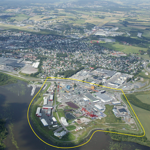
Lillestrøm has a lot of construction activities as a densification of the most central areas next to the station is under way. Within the areas of which the city considers to expand is Nesa, a peninsula located between the nature reserve Sørumsneset, the river Nitelva, and the city centre. Recent changes in ownership have opened a discussion for a new direction for the area. The core industrial activity, a wood adhesives factory with chemical production, represents a hazard its surroundings and is not compatible with urban development. The premise for a coming development is therefore its relocation. The question is how remaining and new production can still be a part of the future of Nesa in concert with housing and public functions. And hence contribute to the ambition of Lillestrøm being a multifunctional city.
Site definition
The site is comprised by entities of various businesses. The main stakeholder is the wood adhesives factory Dynea, which has the largest portion of land at the site. Other businesses involve a pharmaceutical company, an electrical wholesaler and a hardware shop. Due to the presence of industrial activity over long time, areas of contaminated soil have been detected at the site. Traits of current activities also features measurements of security; fences are present features at the site today. Another measurement is the flood embankment surrounding the site. Nesa neighbours the nature reserve Sørumneset, a distinctive wetland with meandering oxbow lakes. Norway Trade Fairs is located between Nesa and the city centre, currently it is being evaluated for a transformation to urbanize the area. Today the building complex is considered as an obstacle between Nesa and the city centre. The train station is situated 1500 meters away from Nesa.
How is Production Considered in the Urban Diversity Program?
In the history of establishments of industries along the river in Lillestrøm, the industrial area of Nesa represents the last one of its kind. In a strategy for transformation, the masterplan needs to deal with Nesa in a scenario where the Dynea factory is relocated. In the future, Nesa should inherit an identity that combines living and production in a new synergetic totality – a mix of functions and typologies. Is it possible to create a strategy where both short-term and long-term programs can contribute in making the new Nesa? Is it possible, through new typologies and co-locations, to have housing and production co-exist? Is it possible to develop an urban productive field that safeguards the natural surroundings of Nesa? What synergies between landscape, nature, production and living can unfold? And how can the Nesa area better be connected to the central areas of Lillestrøm? Europan is the tool to open for investigations on the area’s future, and to create a new vision where Nesa is positioned in the greater urban development area of Lillestrøm and the region. You are hereby invited into that process!
 From the river embankment, looking towards the boat jetty
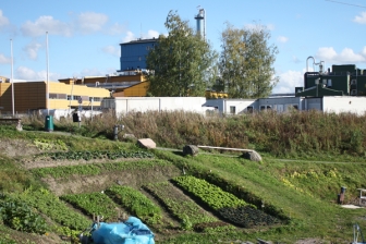
 Urban gardening initiative
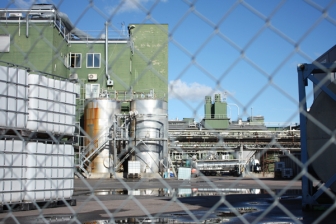
 Dynea Production facilities
Questions à propos du site
The "topography" folder is empty. Is it going to be updated soon? The "terrain" model is very raw.
The topography folder is empty as the information on topography appears in the files in other folders.
The terrain model is "raw": This is probably because the file both has mesh and linework. Please check the folder 'New Docs After Launch', where you can find the 3D-model in three separate files: 'NO-Lillestroem-SS-M2.dwg' is the building volumes in mesh, 'NO-Lillestroem-SS-M3.dwg' is the terrain in mesh, and 'NO-Lillestroem-SS-M4.dwg' is the 3D model in lineworks.
Are there any "shapefile" of the Lillestrøm area?
Regarding the "contaminated soils", what are the contaminants of the area?
Unfortunately we dont have any available 'shapefiles'. There is however a municipal webpage for maps, where you can find additional information like historical maps, flooding zones, property lines etc.
The areas of contaminated soil is due to years of industrial activity, we do not have the specific data of type of toxines.
Is possible to use a drone the day of the visit to survey the interested zone? Could be possible to use a drone on a different day?
We have consulted the site owners on this question and they have responded that it is OK for them that you use a drone. But, they also say that there are certain regulations connected to professional use of drones in Norway, and that you are responsible to be aware of these, read them and check if you are 'qualified'. Here is a link to the webpage where you can read about the regulations connected to the us of drones in Norway.
Do the competitors need to consider ‘Arcasa’s’ project for Olsen’s plot, and the project ‘Portalen’ as already built? On Google Maps ‘Portalen’ is under construction and Otto Olsen’s plot is just an empty space - Is it possible to get the ground floor plans of both projects to valuate a possible connection in a masterplan?
The project ‘Portalen’ is just completed, and is ready for being moved into this summer. The detailed regulation of the project at Otto Olsens plot will be up to first-time treatment in the municipality in august 2017, competitors could consider this as already built. Documents showing ground floor plans for both projects are to be found in the ‘New Docs After Launch’-folder.
Is there an estimate for the amount of people that will live in the project site?
It is estimated that the project site will be regulated with a mix of 50% residential purpose and 50% commercial purpose. The regulation of the residential purpose will then count for an estimated amount of people living there being 3-4000 people.
Is it possible to get a list of owners of the lots included in the Project Site? If not, is it possible to get information about which lots are owned privately and which are owned by the municipality?
All of the properties at the project site are privately owned. The site representatives Aspelin Ramm Lillestrøm AS and BaneNor AS owns the majority of land, in addition to two smaller owners.
The competition brief states that properties on the project site are rented out to the companies at site based on leases. Is it possible to receive information about which site is affected by a lease and when that lease expires?
As a principle, the project site is divided in two areas; the ‘Phase 1 Area’, on the west side of the project site, can be considered as being ready for immediate change. The ‘Phase 2 Area’ (Dynea) is dependent on the existence of the processing plant and has a long-time perspective estimated to be about 50 years (but changes can happen sooner). Detailed information on leases for the specific properties are not being submitted by reason of not putting boundaries on the proposals - competitors are rather asked to focus on developing an overall concept for the site.
Are there any specific urban parameter to be respected (like building heights)?
It is up to the competitors to consider the urban parameters.
Which buildings needs to be restored? Which of the buildings can be demolished?
There are no formal guidelines for protecting any of the buildings at the project site, but competitors are encouraged to consider reuse and transformation of the buildings.
We are working on Lillestrøm project in Norway. None of the CAD files have contour lines with height information. It is hard to understand the topography without having the height info. It would be great to get contour lines as 3D polylines with height info.
A new file with contour lines and height information has been uploaded to the 'New Docs After Launch'-folder' – Title of file: NO-Lillestroem-SS-M5.dwg
In the mobility diagram (called ‘Strategy for Future Infrastructure of Transportation’, page 9) there is a railway crossing the river and branches into two separate directions. While the north branch is visible in the satellite views, the south branch is not. Does the south branch of the railway exist or is it planned?
The south branch of the railway exists, it is called Kongsvingerbanen and it is a railway line going to Stockholm, the reason why it is not visible in a satellite view is because it enters a tunnel on the other side of the bridge. The north branch is called Dovrebanen and it goes north towards Trondheim.
Can the small marina be relocated?
The marina is currently a valuable resource in the area as it is, but competitors are free also to suggest changes and develop this program.
Is it possible to get a dwg-file of the buildings located in the opposite side of the stream?
Yes, a dwg-file is to be found in the ‘New Docs After Launch’-folder. Name of file: NO-Lillestroem-SS-M6.dwg
Should the property boundaries within the Project Site be preserved?
There is no need to preserve the property boundaries, the project site can/should be regarded as an overall area. It is only the boundary separating the processing plant (Phase 2) that should be respected.
Le site est lié au thème suivant
D'une zone productive à la ville productive Quel type d’urbanité pour les zones logistiques et industrielles ? La ville contemporaine est marquée par un urbanisme de grandes surfaces actives et reliées aux réseaux métropolitains, et d’industries plus légères en périphérie des centres-villes. Tous deux fonctionnent en autarcie par rapport aux zones adjacentes à usages monorythmiques.
Quel type d’urbanité pour les zones logistiques et industrielles ?
Le défi sera d’injecter de nouvelles économies potentiellement génératrices de synergies entre les usages, mais aussi de porosités, donnant vie à un milieu urbain polyrythmique. Comment donc développer des espaces communs partageables entre des usagers d’activités différentes et avec les habitants des zones alentour ?
Questions à propos du site
Pour pouvoir poser une question, vous devez être connecté (et, par conséquent, inscrit au concours).
Ve. 16 mai 2025
Date limite de soumission des questions
Ve. 30 mai 2025
Date limite de réponses aux questions
Avant de soumettre votre question, assurez-vous qu'elle n'apparaît pas déjà dans la FAQ.
Merci de poser vos questions sur les sites dans le menu Sites.
Merci de poser vos questions sur le règlement dans le menu Règlement.
Si votre question ne reçoit pas de réponse dans les 10 jours, merci de vérifier qu'elle ne figure pas dans la FAQ sous un autre intitulé ; sinon, contactez le secrétariat concerné par email (secrétariats nationaux pour les sites, secrétariat européen pour le règlement.)