Madrid - Plazas (ES)
Les Dossiers synthétiques et d'enjeux sont disponibles gratuitement.
Merci de vous inscrire et vous connecter pour accéder au Dossier complet de site.
- Dossier synthétique EN | ES
- Dossier d’enjeux EN | ES
- Le site sur Google Maps
- Retour à la carte
Données synthétiques
Échelles de projet XL/S - urbain et/ou architectural
Localisation Madrid / District, Area around Gran Vía / 6 Plazas
Population 3.165.883 hab.
Site stratégique 823.540 m2
Site de projet Plaza de los Mostenses 6.432,35 m2 ; Plaza de Santo Domingo 7.102,48 m2 ; Plaza de las Descalzas/San Martín 4.772,64 m2 ; Plaza del Carmen 5.494,73 m2 ; Plaza de Pedro Zerolo 4.960,22 m2
Site proposé par Madrid City Council
Acteurs impliqués Ville de Madrid
Propriétaire du site Public
Phase post concours Projet de construction
Représentant d'équipe architecte, urbaniste, paysagiste
Information complémentaire
How can the site contribute to the productive city?
This site is part of a strategy aimed at encouraging urban complexity. The Council proposes an exploration of the interrelationship between production activities and the city as a habitat, with a view to promoting a mixed city in the consolidated central urban grid around one of Madrid's main thoroughfares, Gran Vía.
The traditional uses of this area (entertainment, shopping etc.) can be enhanced, while at the same time inserting new uses through the exploitation of sections of public underground car parks. The squares above them can be configured as roof terraces for the underground spaces which will re-emerge, providing new opportunities for activities related to production, logistics (loading and unloading) and urban enrichment.
City strategy
The Madrid City Council has commenced an urban strategy aimed at an overall territorial rebalance, with a special focus on the most vulnerable areas. This initiative is hoped to provide its citizens with a more equitable, liveable and cohesive city by means of a comprehensive, sustainable response to the challenges that our society must tackle urgently, albeit in a responsible manner in terms of the environment, the economy and social cohesion.
One of the most important aspects of the envisaged transformations related to the conditions of this competition is the development of a new, more sustainable Mobility Model and a new Strategy for Public Spaces that will make them more accessible, inclusive and produce a substantial improvement in to quality of the urban space.
The main strategic challenges of the city are focused on the following objectives: Stimulus for the productive city / Territorial balance and social cohesion / Environmental, economic, social and cultural sustainability / Improved quality of life and habitability.
Site definition
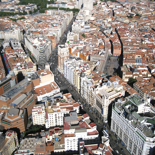
Gran Vía was one of Madrid's major urban operations at the start of the 20th century. This new thoroughfare became the main commercial and cultural hub in the city centre and the trunk route for east-west mobility. In the back streets around it, however, there are several empty public spaces within the compact historic core, which show obvious signs of spatial, economic and social degradation. One of the main reasons for this degradation was the transformation of most of these spaces in the 1970s and 1980s into roofs for underground public car parks, built without consideration of the need for above-ground public spaces, as their design obeyed the technical and economic logic of underground infrastructure.
Three of these squares lie north of Gran Vía: Plaza de los Mostenses, Plaza de Santa María Soledad Torres Acosta and Plaza de Pedro Zerolo. Another three are south of Gran Vía: Plaza de Santo Domingo, Plaza de las Descalzas and Plaza del Carmen.
The City Council now proposes the total urban renewal of these spaces, including the possibility of intervention on the underground car parks and their access infrastructure (vehicle ramps, stairs, lifts, etc.) for a dual purpose: on the one hand, to improve the quality of the public spaces in these squares, and on the other, to insert new uses on the upper levels of the car parks, making them compatible with their parking use, which will be partially maintained.
How is Production Considered in the Urban Diversity Program?
Gran Vía is one of the world's big shopping and entertainment streets. This project offers the chance to transform an area where the usual uses of a city centre can be enriched with production of all kinds (tertiary, micrologistics, shopping, handicrafts, entertainment) to be shared and enjoyed by citizens and visitors alike.
Beneath the squares, which may be regarded as roof terraces for underground buildings, there are several levels used for rotational public car parks. These can be transformed while partly maintaining their uses, albeit with a new focus (partly for residents’ parking, partly for breaking down goods loads, recharging electric vehicles, rental vehicle parking, etc.). New uses (production, cultural, recreational) may also be installed on the top level after studying the spatial connection with the above-ground public space.
New uses are envisaged for the spaces that will be generated by this operation, on the streets and beneath them as well. This will provide added urban planning, architectural, cultural and mobility values to these urban environments, which have become increasingly degraded over the years.
In addition, competitors can also define the essence of a model for loading and unloading hubs in this part of the city, and decide where they can be installed on the basis of the newly generated spaces, with a view to the design of a congruent network that will facilitate loading operations in the heart of Madrid, making the most of their accessibility from Gran Vía, improve mobility and drastically reduce the impact on capillary residential streets in the historic heart of the city.
The proposal thus involves the design of an overall strategy for these spaces (urban strategy), along with a local strategy involving the individual design of one or all of them (architectural strategy).
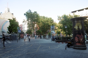
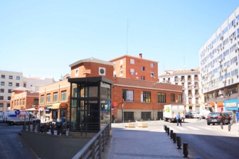 Plaza de Mostenses
 Plaza de Santa María Soledad Torres Acosta
 Plaza de San Martin/Descalzas
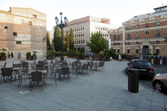
 Plaza del Carmen
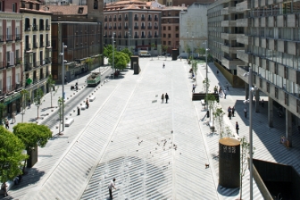
 Plaza de Santo Domingo
 Plaza de Pedro Zerolo
Questions à propos du site
Hi, The cad drawings for Santo Domingo seem to be missing (the link leads to Plaza del Carmen instead) Generally, could you provide us with topographical information with spot levels at surface? Thanks
They have been replaced. Please find now the correct information concerning Plaza Santo Domingo
Tudescos: number of floors? The first floor seems to be smaller. Is this because the second one has on its northern side double high? Descalzas: I would like to confirm if the top slab is inclined? Does the entry from San Martin St lead to second floor? Santo Domingo: Could you provide information about pilars and ramps. Number of floors? Thanks
Santo Domingo sections and new plans are now in the folder "New documents after launching". Sections of Soledad Torres Acosta/Tudescos and Descalzas parkings will be provided as soon as possible.
Hi, I would like to know if the highest area of Pedro Zerolo square was achived through the elevation of the structural slab or if it was simply filled. Hights of ceilings in every floor in P. Zerolo and Carmen or provide sections. Thanks.
Plans have been added. See "documents after launch"
Hi, could you provide the second and third floors of Descalzas square as with only the first one the conections among floors are not clear enough. Thanks.
You will find a new document with more information in the Descalzas Square (ES-MADRID-PS-M6-Parking Descalzas.pdf) in the file “New docs after launching”
Hi, I would like to know if in the area of Las Descalzas square where there is no public parking below is there part of the garaje of Monte Piedad building or not. Thanks.
We don´t know. We guess the parking space of the Monte de Piedad building should be below the building itself and not on public grounds.
Hi, could you provide Plaza de la Luna and Plaza del Carmen sections? Sections of the second one are available in the folder, but only of the first and second floors, so we don’t know the heights of the other floors. Pictures of both parkings could also be interesting. Thanks
The height on the second and third floor of the parking in Plaza del Carmen is, at least, that of a legal public parking (2,10 m gauge). There is not more information on the sections of these two squares.
Hi, I would like to know the number of floors of Tudescos parking, the hights of the ceilings in the first and second floors, and if the floors are flat. Thanks.
There are four floors in the parking. The floors are horizontal. We don´t have the height of the floors.
As Gran Via has a plan of renovation, do we have to intervene this street too or only the surroundings. Thanks.
The competition is for the intervention on the plazas.
Hi! we have a question related to the parking for the surrounding residential areas. Is there a specific number/percentage of parking lots that we have to keep? Thanks!
The object of the competition are the squares and the different uses on the first level of the underground parking. The number of parking lots will be solved by the municipal administration on the lower levels.
Le site est lié au thème suivant
D’infrastructures fonctionnalistes à la ville productive Comment de nouvelles conditions de mobilité peuvent-elles encourager une hybridation entre ville et production? Les infrastructures sont des éléments fondamentaux pour permettre l’économie dynamique de la ville. Mais elles ont souvent été conçues contre l’urbanité de celle-ci : autoroutes, parkings, lieux intermodaux provoquent coupure et renforce la fragmentation urbaine.
Comment de nouvelles conditions de mobilité peuvent-elles encourager une hybridation entre ville et production?
De nouvelles visions de la ville autour d’un modèle de mobilité douce offrent des opportunités inédites de réinvestir ces infrastructures pour les adapter. Mais comment garantir que cela induise une vie urbaine plus durable et une hybridation de programmes incluant les activités productives ? Comment renforcer les infrastructures comme un terrain propice à la ville productive ? Des chaussées déclassées peuvent-elles devenir des rues productives ? Des parkings obsolètes se transformer en lieux productifs ? Des nœuds intermodaux revalorisés générer des hubs productifs ? Et quelles nouvelles logiques d’espaces pourraient se développer à partir de ces scenarii ?
Documents spécifiques
Questions à propos du site
Pour pouvoir poser une question, vous devez être connecté (et, par conséquent, inscrit au concours).
Ve. 16 mai 2025
Date limite de soumission des questions
Ve. 30 mai 2025
Date limite de réponses aux questions
Avant de soumettre votre question, assurez-vous qu'elle n'apparaît pas déjà dans la FAQ.
Merci de poser vos questions sur les sites dans le menu Sites.
Merci de poser vos questions sur le règlement dans le menu Règlement.
Si votre question ne reçoit pas de réponse dans les 10 jours, merci de vérifier qu'elle ne figure pas dans la FAQ sous un autre intitulé ; sinon, contactez le secrétariat concerné par email (secrétariats nationaux pour les sites, secrétariat européen pour le règlement.)