Innsbruck (AT)
Les Dossiers synthétiques et d'enjeux sont disponibles gratuitement.
Merci de vous inscrire et vous connecter pour accéder au Dossier complet de site.
- Dossier synthétique EN
- Dossier d’enjeux EN
- Le site sur Google Maps
- Retour à la carte
Données synthétiques
Échelle de projet L/S - urbain + architecturale / architecture + contexte
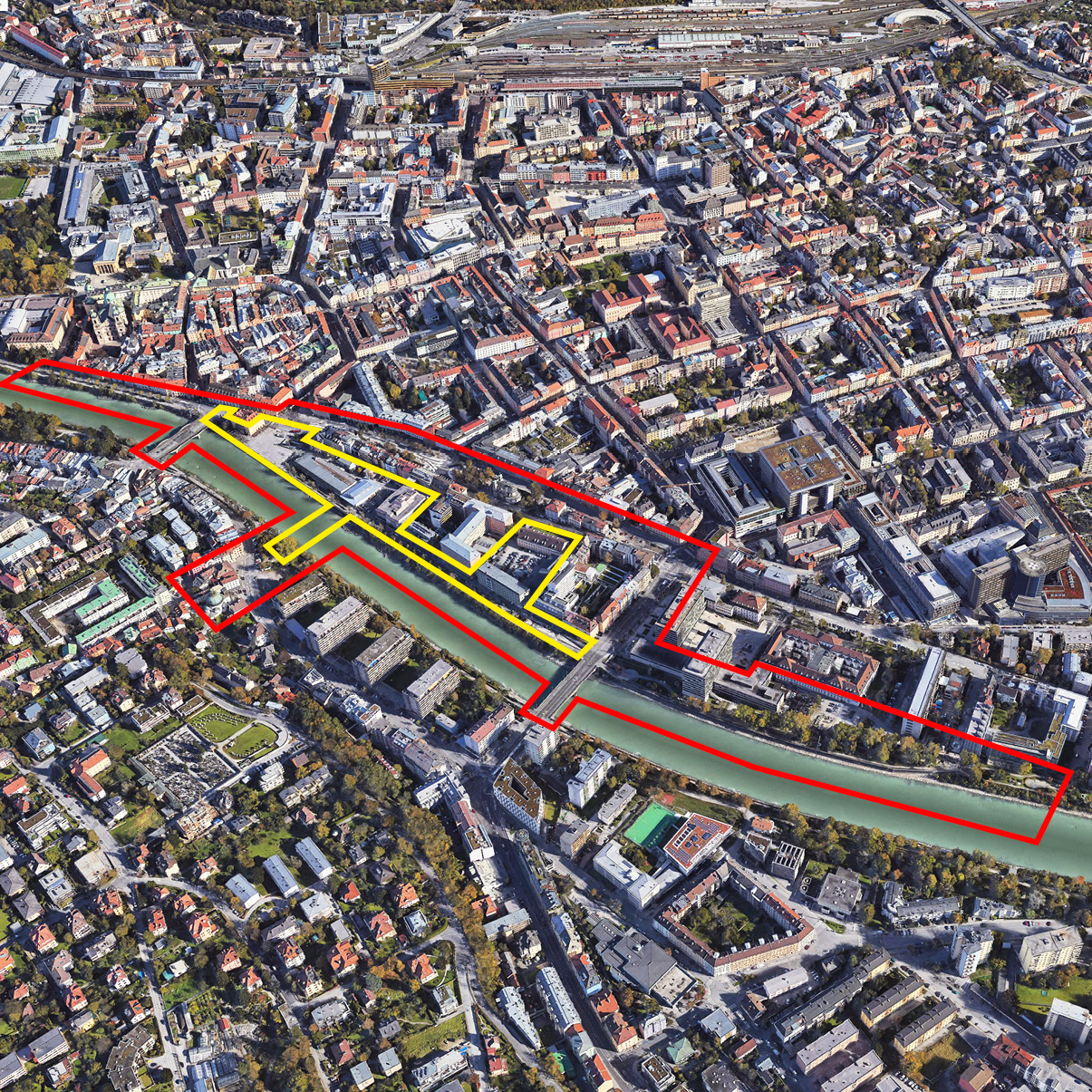
Localisation Innrain, Innsbruck, Tyrol, Autriche
Population Innsbruck 133 540 hab. ; Agglomération 156 690 hab.
Site stratégique 17,5 ha – Site de projet 3 ha
Site proposé par Ville d'Innsbruck
Acteurs impliqués Ville d'Innsbruck et IIG-Innsbruck
Propriétaires du site IIG-Innsbruck Immobilien Gesellschaft
Phase post concours Commande pour une stratégie urbaine impliquant les équipes primées est souhaitée
Représentant d'équipe Architecte - urbaniste - paysagiste
Information complémentaire
How can the site contribute to a productive city?
Innsbruck’s newly elected government has an extremely ambitious plan for the city. Goals are already set for soft mobility, sustainability, densification and reuse, green and open spaces, job preservation and creation, and participation. Everything is geared towards a resilient city with short distances. The E15 site doesn’t just sit within this progressive framework of ideas, it is perfectly located on a central spot in town, where all of the above-mentioned ideas come together at once. A central question will revolve around a concept for a future Market Hall. Nothing less than a pioneering vision for a lively, open and innovative space is required. A multifold of production facilities with strategically-designed synergies should act as a trigger for the whole area.
City strategy
Innsbruck’s beautiful setting between impressively high mountains is unequalled. Inevitably the compact city has limited spatial resources. Densification, reuse and restructuring built-up areas are therefore main objectives for the urban development. Another major focus lies on a sustainable mobility strategy. With its prominent location the site is a pivotal point where several mobility strands cross and by-pass, making this task exceptionally important. Bringing Innsbruck back to the banks of the river Inn, which runs along the site, is another key issue here. One of the largest and most interesting inner-city development areas, the E15 site is ideal for all these goals. The city sees it as a crucial mosaic for a propulsive and visionary development of Innsbruck - and rightly so.
Site definition
The E15 site in the very heart of the city facing the most picturesque scenery of Innsbruck - colourful housing with huge mountains in the background - is typically Tyrolean. The site’s enormous potential is barely used despite its prime location. It comprises of a vast central square and a charming market hall which could both be improved upon, a parking garage (to be removed) and a huge office block (soon to be vacated). The challenge here is to strategically restructure the area, activate all possibilities and initiate new synergies. The future market-hall will be a key theme for this development. Come up with the epitome of a visionary and innovative hub that gives a fresh identity to the area.
How is production inserted in the urban diversity programme?
Every inhabitant of Innsbruck knows the E15 site. It is so central it seems everything happens here: there are tourists, bikes, cars, cafes, shops, the market, restaurants and people simply strolling around… Yet it lacks identity.
The connection with the river is missing, the definition of the square is vague, mobility strands are not clear, openings and see-throughs are absent. However, it is an ideal testbed because the site is extremely popular with its inhabitants and new ideas will be eagerly anticipated. Participation will be integral to the process. The Market Hall brings the image of production to the site and here a boost can be initiated. Universities are in the neighbourhood so think start-ups and prototyping. Craft and trade are well-supported in this area. Sustainability and nature are key topics. Water is next to the site. Clearly an enormous potential for synergies is at hand.
The main challenge is to restructure the site, keep it inclusive, yet exciting and give it a clear identity. Simply put, come up with your staggering vision for a conglomeration of production, exchange and creation. Generate the very image of a resilient city hub!
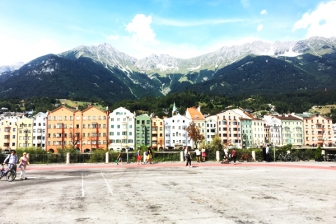 Market Square with view towards the opposite river bank
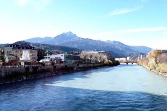 View from "Innbrücke" towards the South West of the city & project site
 Market Hall place and main entrance
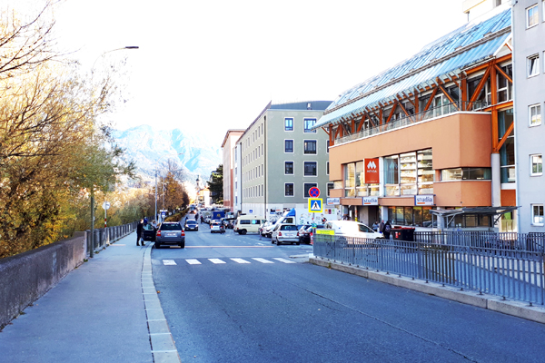 Riverbank and the street longing the project site, from the Southern access point
Questions à propos du site
Dear Europan Team, Is it possible to get a full 3D Modell with the ground and the streets from the site? Thanks! kind regards
There is no other 3D Model available, only the one provided in the download section.
Hi! A question regarding the A1 panel submission: are we free to prefer a vertical or horizontal layout?
The panels must comply with the specification of the submission, which says 3 vertical A1 panels.
see rules of the Europan15 competition, 4.4: Items to submit
https://www.europan-europe.eu/en/session/europan-15/rules/
Hello! Are there sections of the building Innrain 34 (Polizeidirektion) available?
No, there are no sections available. The approximate room height on ground floor level is 3,4m and on upper levels it is 3,20m.
Is a bilingual submission allowed (German, English)? Does a bilingual submission increase the booklet allowance from 3-4 pages to 6-8 pages? Thank you.
Yes, a bilingual submission is allowed. If the entry is bilingual, the project booklet can be 6-8 pages long (1 PDF version for both languages). The submission in English is compulsory.
Would you have the 3D_isocurves_laserscan.dxf file in RECAP format? So that I can insert it in AutoCAD as a Point Cloud and cut it with the Section Plane. Thank you!
No, sorry, there is no RECAP format available.
How should the 350 parking be considered? Will it be demolished or should it be kept and reused? There is different answers fot this topic in the site brief and the FAQ answers. Could you clarify please? Thank you.
The parking garage is in bad condition, therefore demolition is envisaged. It is up to the teams to distribute those car parking spaces on the project site. A reduction of car parking spaces can be assumed, if a sound mobility concept is proposed, that shows adequate alternatives. (At the moment the project site houses 350 parking spaces in the aforementioned parking garage and 200 additional spaces in the underground parking BOE below the market square.) The BOE parking garage has to keep its function.
Should the Terra Nova proposal be absolutely be considered for our project? Or can we ignore it?
The Terra Nova proposal is the winning project of a realization competition held by the civil construction authority of Innsbruck and should be realized in the future. As this area is only part of the strategic site and not the project site; it is up to you and your concept whether you want to consider the proposal or not.
Does the Polizeidirektion has a basement/cellar? Are there any further informations about the new parts of the building (when was is built?)
Some parts oft the builidung have a cellar, the newer part was errected in 1948.
Good morning. We have got many problems to manage the file 3D_isocurves_laserscan, which is too heavy to extract the topography datas. Can you olease suggest us an easier method that we may not know to use it properly or an alternative file to get the same datas?
The 3D_isocurves_laserscan is meant as a reference to help understand the topography of the site. Due to huge data is it not meant to transfer and use it in AutoCad.
Is it possible to have underground parkings? If yes, how many levels are allowed?
The parking garage (BOE) has two levels. Due to the proximity to the Inn (groundwater), the number of underground garage levels has a direct influence on the technical feasibility and the resulting costs.
It would be possibile to know the traffic direction in the Herzog-Siegmund Ufer when the streets goes behind the market hall? It seems to be a one way road but from the material we have is not possibile to understand the direction. Thanks
The current traffic situation can bee seen in the plan “AT-Innsbruck-TrafficRoutes-20190619.pdf”, now available for download. You are free to propose a different traffic route if better and more suitable for a coherent concept.
How does the delivery of the market currently works? It would be possibile to know the size of the trucks used for delivery?
The current traffic situation can bee seen in the plan “AT-Innsbruck-TrafficRoutes-20190619.pdf”, now available for download. Truck sizes: Semi-trailer: max. length 25m, width 2,60m, height 4m Delivery times: 02:00 - 09:00, Morning: small truck (length 18m), Afternoon: hardly any deliveries.
The strategic site perimeter is sometimes adjacent to existing buildings. Is there a minimum distance required? Is this distance required also if the existing building has a blind facade?
In the city of Innsbruck, density and distances are usually regulated by development plans. For the specific case, existing development plans would have to be looked at or project-related new development plans would have to be created. At this point in the project, continuous development on blind facades is possible. Please note, for the competition the project should focus on a sound concept and an overall vision.
1) Is it possible to obtain 3D-Data or plans/sections for the building Innrain 30? (it is not included in the provided 3D-Data)
No, sorry, there are no plans or sections available for the building Innrain 30. It is not that important because it is only part of the strategic site and not the project site.
2) Is it possible to obtain sections through the river Inn and its banks in order to clarify the height developement? (this information is not available in the provided files)
The information is now available to download. Please see file AT-Innsbruck-CrossSection-20190617.pdf
3) In the brief it is mentioned, that the extension of the river profile is feasible, however there are various infrastructure lines (electricity/Telekom/Gas etc.) running underground next to the river. Can we assume that it is not a problem to move these infrastructures?
There are underground pipes in the area around the market hall (electricity, canal, water etc.). Changing those (if possible) is technically very complex and very expensive.
What size are the trucks used for delivery to the market and what are the delivery times? Are there currently conflicts of use regarding residential use and delivery?
Semi-trailer: max. length 25m, width 2,60m, height 4m
Delivery time: 02:00 - 09:00
Morning: small truck (length 18m)
Afternoon: hardly any deliveries
Problems with neighbours belong to the past. The adjacent Basic Hotel had problems with the semi-trailer at 02.00 in the morning. It was often too noisy. Speaking with the suppliers 8 months ago, the problem is now solved.
Is there a demand for 1) more space for gastronomy 2) more space for market stalls?
Depending on your concept, it is up to you to suggest a sound use mix for the whole area and the market hall of the future.
Le site est lié au thème suivant
IMPLANTER IMPLANTER Usages productifs
Usages productifs
Pour que les villes deviennent à la fois productives et durables elles doivent relier les ressources, les mobilités et les conditions d’équité pour créer de nouvelles dynamiques selon deux aspects : des milieux productifs et des usages productifs.
Les usages peuvent devenir productifs s’ils dépassent leurs propres limites fonctionnelles : les usages productifs fonctionnent comme un déclencheur qui peut initier des dynamiques d’évolution de manière à transformer l'environnement autour. Ils sont une réponse à une situation dans laquelle l’absence de dynamiques a provoqué une « ambition d’usage » puissante, l’exigence d’un programme crédible, un catalyseur de changement qui s’insère parfaitement dans le contexte existant.
Questions à propos du site
Pour pouvoir poser une question, vous devez être connecté (et, par conséquent, inscrit au concours).
Ve. 16 mai 2025
Date limite de soumission des questions
Ve. 30 mai 2025
Date limite de réponses aux questions
Avant de soumettre votre question, assurez-vous qu'elle n'apparaît pas déjà dans la FAQ.
Merci de poser vos questions sur les sites dans le menu Sites.
Merci de poser vos questions sur le règlement dans le menu Règlement.
Si votre question ne reçoit pas de réponse dans les 10 jours, merci de vérifier qu'elle ne figure pas dans la FAQ sous un autre intitulé ; sinon, contactez le secrétariat concerné par email (secrétariats nationaux pour les sites, secrétariat européen pour le règlement.)