Rotterdam Kop Dakpark (NL)
Les Dossiers synthétiques et d'enjeux sont disponibles gratuitement.
Merci de vous inscrire et vous connecter pour accéder au Dossier complet de site.
- Dossier synthétique EN
- Dossier d’enjeux EN
- Le site sur Google Maps
- Retour à la carte
Données synthétiques
Échelle de projet L/S - urbain + architecture / architecture + contexte
Localisation Rotterdam, Marconiplein, Kop Dakpark
Population 650 000 hab.
Site stratégique 20,4 ha – Site de projet 1,1 ha
Site proposé par Municipalité de Rotterdam
Acteurs impliqués Municipalité de Rotterdam, St. Dakpark, Groene Connectie, Delfshaven Coöperatie, winkeliersver. Bigshops
Propriétaires du site Publics et privés
Phase post concours Conception (ou études de conception) pour une réalisation sur le site (ou sur un site aux caractéristiques similaires) commissionnées par la Municipalité de Rotterdam et/ou des partenaires privés.
Représentant d'équipe Architecte, urbaniste, paysagiste
Information complémentaire
How can the site contribute to a productive city?
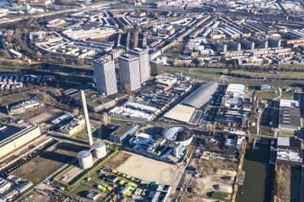
The construction of the Merwe-Vierhavens (M4H) was accompanied by the construction of the working-class neighbourhoods Bospolder to accommodate the dock workers. The initial reciprocity between the port and these neighbourhood has now ceased to exist. In areas like M4H, traditional industry is being replaced by the next economy, while residents in the surrounding neighbourhoods are struggling to keep up. The new building block on the plot at the beginning of the ‘Dakpark’ (=rooftop park) – inserting work-homes for different generations and income brackets – should restore the social and economic connections and become the missing link between the old and the new economy, between blue-collar and white-collar labourers, between living and working.
City strategy
The City of Rotterdam seeks opportunities to accommodate its growth in the existing city. Densification of urban voids, in particular the ones near a public transport hub, with a strategic position in the city is part of this strategy. This type of development is ideally suited to catalyse new interaction milieus, since it offers the opportunity to implement a new work-and-live programme connecting citizens with all sorts of backgrounds, knowledge and skills, various (economic) activities and other ‘resources’ that are already present in the surroundings. Especially urban voids that are at the intersection of multiple neighbourhoods with diverse urban dynamics, like the plot at the beginning of the ‘Dakpark’, offer unorthodox anchors for such productive milieus.
Site definition
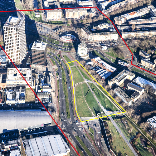
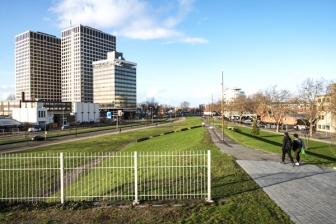
The project site is an urban void situated in western Rotterdam next to the Marconiplein, an important public transport hub and gate to the inner city. It is at the intersection of several residential areas originally planned for the working classes – Bospolder, Tussendijken, Spangen and the Witte Dorp – and the port area M4H that is being transformed into an innovative makers district. Between M4H and Bospolder there is the ‘Strip’, an elongated building with a range of large chain stores and a lively communal park on top. The challenge is to develop a radical spatial intervention on this site – meaning a new building with innovative workhome typologies for various generations and income brackets – to create a new centre of activities that restores social and economic connections, revitalizes ground floors with (public) economic activities and fuels the urban dynamics in all neighbouring districts.
How is production inserted in the urban diversity programme?
Rotterdam is growing. The city aims to build 50,000 new homes in the next decade and to vigorously enhance the quality and energy performance of the existing built environment. Rotterdam is looking for ‘good growth’: building a compact, circular, productive, healthy and inclusive city with equal opportunities and high quality of living for everyone. It aims to be a vibrant and welcoming place for people of all walks of life, ages and beliefs, enabling them to prosper. Citizens of Rotterdam should be able to live productive lives by working, learning, caring or in any other way contributing to the development of the city and its narratives. Therefore, it is important to remove barriers, to increase connectivity.
Europan 15 focuses on sites that might catalyse opportunities on multiple levels, places of meaning that might enhance the city’s social resiliency. These are some of the abstract notions rooted in the new Rotterdam vision and regulatory framework on spatial and socioeconomic developments, called the Omgevingsvisie. This framework is currently being drafted by the municipality. It should accelerate innovative spatial solutions and sustainable socioeconomic developments. It is supported by an extensive participatory process and an action research program. The Europan15 sites have been selected to implement this process, through research-by-design and its aim of implementing exemplary projects.
 In-between Bospolder & the port area in transition of Merwe-Vierhavens
 Perspective of the plot: view towards Marconiplein from Dakpark
 The park: in-between Merwe-Vierhavens (left) & Bospolder (right)
 Perspective of the plot from Marconiplein
Questions à propos du site
In the complete site folder there is an empty subfolder with the name "PS-e_maps-topography". Since the site is L/S and the park has a steep slope, I wonder if some more information about topography or the height of the surrounding buildings is going to be given soon or if we should find it by ourselves.
There is an online 3D model of Rotterdam: https://3drotterdam.nl. In this model you can create your own section and export the file.
where can we find the heights and levels of the streets and surrounding buildings? I could not find them on the CAD files Thanks
There is an online 3D model of Rotterdam: https://3drotterdam.nl. In this model you can create your own section and export the file.
Is there any information about the building size, a concrete program of the intervention or an estimate of how many people will live/work here ? Is it a part of the assignment to find the scale of the intervention?
The percentage of the plot that can be built is not defined. Only the maximum height of 50 meters for the whole plot is defined. It cannot be as high as the Marconi Towers. However, it’s a competition. You are allowed to think outside the box and be critical. A pricelist with the calculation method of (social) house prizes per m2 will be added to the Complete Site Folder. The assignment asks for a mix in housing, aimed at offering homes for a.o. people already living nearby in BoTu. You can challenge the plan-sizes and amounts of dwellings and types. Be sure to look for ways to think through the live-work typology of the building. For feasibility reasons on social housing, the housing corporations need to build at least 50 houses on each site to be able to develop, so this threshold is relevant also here to take into account. On the site the Municipality wants to build 100-120 houses with the following division: 50% social; 25% lower-middle-class; 25% higher-middle-class or high; 0% very-high or ‘happy few’ category. However, as Europan wants to innovate, please be critical.
I would like to ask if there is any report of the site visit or it will be added soon? If yes, where can I find it? In the complete site folder there isn't any new file. Moreover, do you have any section of the site?
The report of the site visit can be found here:
https://www.europan-europe.eu/media/default/0001/18/e15_nl_kopdakpark_site_visit_report_pdf.pdf
Unfortunately we do not have a section of the site. You can however find the height of the ground level in general on this website:
Good morning! After reading the report of the site visit We would like to ask 2 questions. Where is the section of the dike? We cannot find it in the complete site folder. Should we keep the existing slope running from Marconiplein till the entrance of the car park? Is it park of the dike structure? Thank you so much!
The Dakpark doubles as one of the most important dikes in Rotterdam. So please consider its infrastructural value for water safety in thinking through possible manipulations of the dike and park slope. A height map of the site has been supplied by the municipality and will be uploaded as JPEG into the site folder at the beginning of next week.
Le site est lié au thème suivant
CRÉER DES PROXIMITÉS CRÉER DES PROXIMITÉS Tiers espaces Entre
Tiers espaces Entre
Dans l'espace physique de la ville, mais aussi aux échelles temporelles et des acteurs, il s'agit d'établir des proximités entre habiter et travailler à l’intérieur de quartiers résidentiels et entre les quartiers résidentiels et les zones de production monofonctionnelle. Il s’agit aussi de repenser le passage de la mobilité métropolitaine à grande vitesse vers la vitesse plus lente des quartiers.
Un tiers espace est un nouvel espace inséré entre aires résidentielles et de production qui peut déclencher la transformation des cycles actuels de production en créant des synergies avec les territoires urbains et de la vie quotidienne. Il peut se trouver dans les espaces résiduels à l’intérieur de quartiers, entre les zones monofonctionnelles existantes ou émerger d’un tissu urbain recyclé.
Questions à propos du site
Pour pouvoir poser une question, vous devez être connecté (et, par conséquent, inscrit au concours).
Ve. 16 mai 2025
Date limite de soumission des questions
Ve. 30 mai 2025
Date limite de réponses aux questions
Avant de soumettre votre question, assurez-vous qu'elle n'apparaît pas déjà dans la FAQ.
Merci de poser vos questions sur les sites dans le menu Sites.
Merci de poser vos questions sur le règlement dans le menu Règlement.
Si votre question ne reçoit pas de réponse dans les 10 jours, merci de vérifier qu'elle ne figure pas dans la FAQ sous un autre intitulé ; sinon, contactez le secrétariat concerné par email (secrétariats nationaux pour les sites, secrétariat européen pour le règlement.)