Tuusula (FI)
Les Dossiers synthétiques et d'enjeux sont disponibles gratuitement.
Merci de vous inscrire et vous connecter pour accéder au Dossier complet de site.
- Dossier synthétique EN
- Dossier d’enjeux EN
- Le site sur Google Maps
- Retour à la carte
Données synthétiques
Échelle de projet S - architecture + contexte
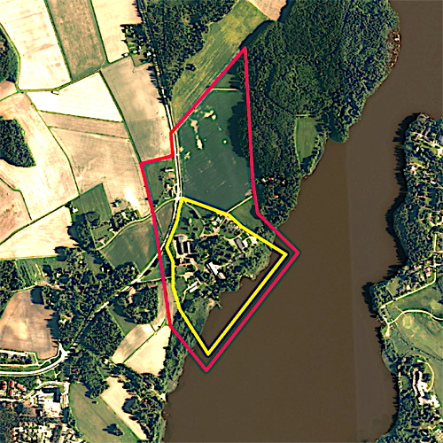
Localisation Tuusula, Hyrylä
Population 38 600 habitants
Site stratégique 41 ha – Site de projet 15 ha
Site proposé par Municipalité de Tuusula
Acteurs impliqués Municipalité de Tuusula
Propriétaire du site Municipalité de Tuusula, propriétaires privés
Phase post concours Étude urbaine, masterplan
Représentant d'équipe Achitecte - urbaniste - paysagiste
Information complémentaire
How can the site contribute to a productive city?
The project site, Anttila farming centre, is situated in a beautiful rural landscape by Tuusula lake, near Hyrylä centre. Anttila has served as a research and education centre for farming but has become mostly vacant. Large barns and research buildings together with housing are available for new use. Some of the old farm buildings are suitable for food production, or they could be converted into something new, even into housing. The goal is to find new ideas and concepts for the area. How could local food production, services and housing coexist in Anttila a new way? How could Anttila become a post-agrarian productive village?
City strategy
Tuusula municipality is part of the Greater Helsinki area, located only half an hour from Helsinki and 15 minutes from Helsinki-Vantaa airport. Tuusula is a combination of active municipal centers and peaceful countryside. The three centres – Hyrylä, Kellokoski and Jokela – each have their own identity. The Tuusula city strategy is to grow via densification.
Lake Tuusula is an inherent part of Tuusula’s identity and cultural heritage. A unique community of artists formed on the shores of the lake in the early 1900’s and this heritage is still prominent today. Enhansing the recreational use of the lake is currently one of the municipality’s key development projects.
Site definition
Anttila farming centre is situated near Tuusula lake, 3 km from Hyrylä. Hyrylä is Tuusula’s administrational center with 20 000 inhabitants. Anttila consists of several historically valuable farm buildings, such as a cowshed from the 1930’s. There are also buildings that are at the end of their life spans, as well as housing.
The history of Anttila is long and the most active years were 1940-1980 when Anttila functioned as a national test farm for new crops. When the research center moved out, Tuusula municipality purchased the area with its buildings. Since then Anttila has been used for education, greenhouse farming and storage, or rented out for various uses. The area is currently in a stagnant condition and is in need of revitalisation.
How is production inserted in the urban diversity programme?
The task of the competition is to create a vision for the Anttila area. The competitors are asked to propose new use for the old buildings and to incorporate housing for the site. Productive themes will be addressed by asking:
• What kind of production could fit in the old protected buildings?
• Could Anttila function as a platform for developing ecological food production methods?
• How will food production evolve in the future? What kinds of facilities will it require?
• How could production and housing coexist in Anttila in a new way?
• What could Anttila offer for Hyrylä, for people who live in the Greater Helsinki area or for international tourists?
• How can Anttila reinvent itself as a popular destination in Tuusula?
• What kinds of temporary uses could Anttila have?
• How will the new development of Anttila resonate with the cultural heritage of Tuusula?
• What kind of a role will Lake Tuusula play in the future of Anttila?
 Aerial view from the West
 Protected cowshed
 Greenhouses
 Tuusula Lake
Questions à propos du site
How much should the proposals interpretate the amount of housing ? Is it a fixed requirement ?
The number is not fixed, however, you have to include some housing into your proposal. See competition brief 4.2 DESIGN GUIDELINES / Housing on page 20.
Why was the South entrance road deviated from its original entrance ?
Unfortunately the reasons behind the evolution of the road are not fully known.
Who is commissioning the private houses in construction just next to the site (South West) ?
The municipality sells the lots to individual families who develop and build their own house.
What kind of crops was being grown before agriculture production stopped ?
Many plants were tested in the area, such as different varieties of grains, beans, potatoes and flowers. Before that Anttila was an ordinary farm that presumably grew rye, wheat and barley.
How is the disabled people center handled ? Are they children, or adults ? Where do they live today ?
Day centre Kettunen offers activities for people with intellectual disabilities. The customers are mainly young adults who live in their own homes outside the competition area.
Would you have a plan of the two individual houses that are to be kept, and eventually the warehouse behind the barn ?
The two warehouses behind the barn are buildings no 725 and 736. We have already provided drawings of 725. Unfortunately there are no drawings of 736. Also, there are no drawings of the two houses no 722 and 724.
Would it be posible to have an extended DWG version of the site in which the whole lake perimeter appears? Would it be available with terrain contours, settlements and infrastructures?
We have now added files (pdf and dwg) with the requested information. The northern part of the lake is in Järvenpää and therefore missing from the files.
Would it be posible to get more information about the soil condition and type in both the site and extended site?
Unfortunately there's no additional information available about the soil condition.
Le site est lié au thème suivant
IMPLANTER IMPLANTER Milieux productifs
Milieux productifs
L’enjeu pour que les villes deviennent à la fois productives et durables est de relier les ressources, les mobilités et les conditions d’équité. Il y a deux aspects à l'implantation de nouvelles dynamiques ou à la réactivation de ressources telles que l'agriculture urbaine et les forces éducatives, de recherche ou créatives : des milieux productifs et des usages productifs.
C’est le niveau auquel un environnement naturel, culturel, social ou économique est implanté ou revitalisé de façon symbiotique, par opposition à l’architecture des objets ou à l’urbanisme technocratique. Ce qui est nécessaire, donc, c’est d'activer les ressources humaines et non-humaines ainsi qu'un écosystème de partenaires, tout en étant attentif aux valeurs d’intégration entre la nature et la culture.
Documents spécifiques
Questions à propos du site
Pour pouvoir poser une question, vous devez être connecté (et, par conséquent, inscrit au concours).
Ve. 16 mai 2025
Date limite de soumission des questions
Ve. 30 mai 2025
Date limite de réponses aux questions
Avant de soumettre votre question, assurez-vous qu'elle n'apparaît pas déjà dans la FAQ.
Merci de poser vos questions sur les sites dans le menu Sites.
Merci de poser vos questions sur le règlement dans le menu Règlement.
Si votre question ne reçoit pas de réponse dans les 10 jours, merci de vérifier qu'elle ne figure pas dans la FAQ sous un autre intitulé ; sinon, contactez le secrétariat concerné par email (secrétariats nationaux pour les sites, secrétariat européen pour le règlement.)