Weiz (AT)
Les Dossiers synthétiques et d'enjeux sont disponibles gratuitement.
Merci de vous inscrire et vous connecter pour accéder au Dossier complet de site.
- Dossier synthétique EN
- Dossier d’enjeux EN
- Le site sur Google Maps
- Retour à la carte
Données synthétiques
Échelle de projet XL/S - territoire / architecture + contexte
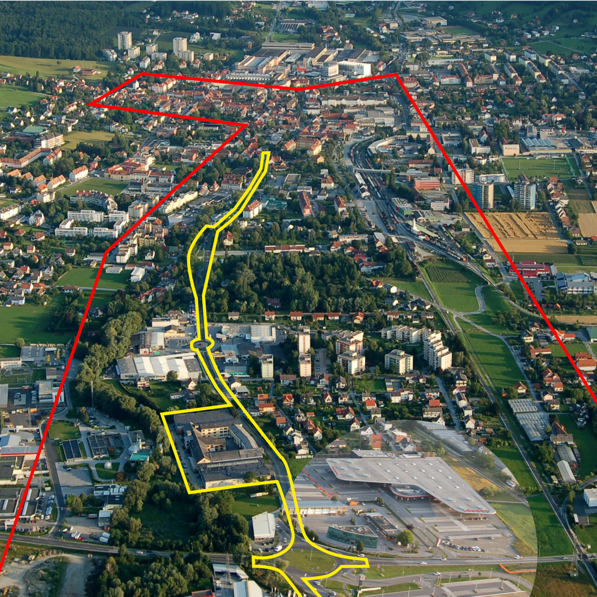
Localisation Gleisdorferstraße, Weiz, Styrie, Autriche
Population Weiz 11 700 habitants ; Agglomération 20 000
Site stratégique 100 ha – Site de projet 4,8 ha et 19 ha pour la zone de projet étendue
Site proposé par Municipalité de Weiz, Province Fédérale de Styria
Acteurs impliqués Municipalité de Weiz, Province Fédérale de Styria
Propriétaires du site Municipalité de Weiz, Province de Styria
Phase post concours Plan structurel et guide de conception pour l'espace urbain
Représentant d'équipe Architecte - urbaniste - paysagiste
Information complémentaire
How can the site contribute to a productive city?
Weiz is exceptional. In contrast to other regional cities it is booming: the economy is strong, the population is increasing, jobs are being created and buildings and research institutions are expanding. Many exciting new projects have recently been realised or are in the pipeline. However the biggest project of all is the new mobility artery which is currently under construction and includes a rail track for commuter trains, a road, a bike path and several footbridges. Profound changes will result from this enterprise. The E15 site - that runs in parallel to the axis - looks at the overall scale of this unique transformation.
The city’s ambitious plan is a visionary strategy, which fosters inventive typologies and new forms of businesses along with potential synergies knitted into the existing framework.
City strategy
Enormous building activities have taken place in the last few years and many more are planned. The new mobility artery is a chance for further growth attracting both developers and inhabitants. The city has designated various target areas for development already. However the overall scheme is missing. Now is the time to act in order to propel all these development activities in one great visionary and innovative direction.
The new artery runs straight through a long stretch of the municipal area of Weiz. It is parallel to the old country road which was always the main street of the village. The city now expects a shift from one axis to the other, changing the traditional main route through Weiz. What potential arises out of the new situation for the old street and its neighbouring spaces?
Site definition
This unique site will shape the whole city at a time of great change. For generations a fascinating urban fabric of single longitudinal strips has formed together with a small river and main roads. Longitudinal axes are dominant. The new mobility line continues this trend, strengthening the formation. Crossing transversally you experience many diverse atmospheres. With the shift from one axis to the other the purpose of the existing road will change. The potential for cross-connections therefore becomes substantial and together with new forms of innovative typologies and pilot projects an explosion of possibilities for all city users can be generated. Europan looks at the greater picture but will use vacant spaces as starting points for its proposed visionary strategy.
How is production inserted in the urban diversity programme?
The city of Weiz is embedded in a network of neighbouring villages. The new artery connects Weiz with Graz, the Styrian capital 45 minutes’ drive away, and with the surrounding region as well as improving connections in the city itself. Three stops are planned in Weiz, making it the first project of its kind facilitating access by bringing trains into the village. Business already has a strong presence in Weiz. In total the city provides 11,300 jobs. However trade, industry and craft are only found on a small scale. A tiny creative scene is establishing itself around the main square. As an education centre Weiz has access to the future generation - a unique opportunity! With a breeding ground for pilot projects, start-up clusters and innovative working typologies young people could be attracted to stay. Smart mobility concepts are already in place supporting this idea. Europan will connect the existing with the new and deliver ideas for resilient synergies.
The main challenge lies in the consideration of multiple aspects, including nature, economy and community. A complete strategy for a sustainable city is needed and individual interventions across the entire field should be proposed in order to anchor and concretise the project.
 Arial view of Gleisdorferstraße and Weizbach on the righ
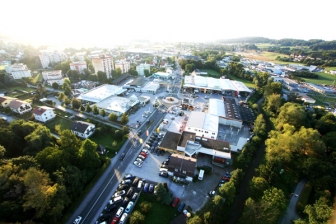
 Old country road - Gleisdorferstraße and Weizbach with vacant `inbetween ́ space
 The new mobility axis: generator of change
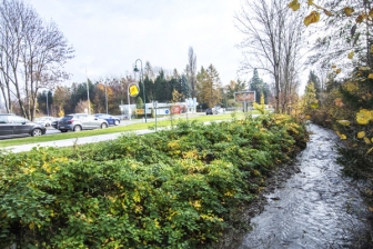
 Parallel road - typical streetscape
Questions à propos du site
Does it exist any topographic plan of the area? It would be interesting to be studied for a better understanding of the site's nature.
The plans on topography are now in the download section:
AT-Weiz-topography-1m_contours10cm_3d.dxf
AT-Weiz-topography-dgm1m_contours50cm_3d.dxf
Is there a topographic survey of the site project? Plans provided indicate points but no altimetry exists. Existe t'il un relevé topographique du site du projet? Les plans fournis indiquent l'existance de point mais ils n'ont pas de cote altimetriques.
The plans on topography are now in the download section:
AT-Weiz-topography-1m_contours10cm_3d.dxf
AT-Weiz-topography-dgm1m_contours50cm_3d.dxf
In the site brief it's asked to include a 1.2500 scale plan of the hole site but it doesn't fit the A2, it is a mandatory scale or we can adapt it? Thank you
Please note, the panel size is A1 and not A2.
The required plan of the project site (yellow line) scale 1:2500 will fit with on a A1 panel.
Can you make available drawings (floor plans, sections, elevations) of the former tannery?
There are no plans on this building available. The building should be seen as a potential project site for new uses supporting the concept of the vision along Gleisdorferstraße.
The property might be sold by 2022 but it is not yet clear what will happen then. The old tannery is located in the flood exclusion zone, which means, if the building would be demolished, no new one can be built. Only existing buildings in the flood exclusion zone can stay. A renovation or adaptation of the existing building is possible.
Can you add a danger zone plan of the project site to the site maps?
Please refer to the map AT-Weiz-SS-M4.pdf. There is no additional map available.
Are there existing green-space concepts for Weiz, the project area and/or the area of the main train station/“Neues Stadtquartier” which should be considered?
The intention is to create micro parks in the years to come and in addition to that there is a large area ( the Augsten plots) north of the main square of the city which should remain a green space as an ecological compensation area for the city. Besides those ideas, no further green- space concepts exist. The Weizbach with its wild nature is also seen as a valuable green space.
Does the city has visions for the plots 975/3 and 975/7? They are close to the “Neues Stadtquartier” – are there plans to include them into this area?
“Neues Stadtquartier” is one of the new development areas on plot 980/2 with plans to build a cinema and a shopping centre embedded into a park. In close proximity to the innovation centre, the idea behind this, is to create an urban mix of buildings in combination with a green area. Currently there are no plans to include the plots 975/3 and 975/7 into this development. They are not owned by the municipality.
How many cyclists are using the cycleways in the project area nowadays? How often are Weiz-City bikes used? Does usage data exist on which the proposed cycleway concept (AT-Weiz-SS-M5) is based that can be made available?
A bicycle counting machine has just recently been installed in the City centre and will provide exact data in future years. From the rental statistics for 2018 it can be seen that most users rent a bike for 10 to 50 minutes. It is very popular to borrow a bike at the station and give it back at the school center or vice versa. Or the borrowing takes place at a rental station in a larger housing estate and leads to the large industrial enterprises Andritz and Siemens or back. The average use for such rides are approx.10 minutes. At bike stations near accommodation establishments rental time is much longer.
There are currently 13 stations: 1. Main Square, 2. roter Turm, 3. Rudlpark, 4. Innovationszentrum W.E.I.Z. , 5.Florianigasse, 6.Voelpesiedlung, 7.Bahnhof (main station), 8.Roseggergasse, 9. Garten der Generationen, 10. Preding Landstraße, 11.Wegscheide, 12. Weiz Mitte, 13. St. Ruprecht/R.
Please find further information on http://www.tourismus-weiz.at/de/stadt-region/stadt-weiz/verkehr-parkplaetze/weiz-bike
(The webpage is in German, but at the end of the page there is a folder to download, which shows the bike stations.)
Does Weiz has concrete plans/visions for the plot area of the “Magnet Küchen Center” (921/2) and it´s neighbouring plots (953/4, 953/5, 953/6, 951/1)?
There are no concrete plans; the plot is privately owned.
What is the purpose of the lay-by besides the road vis-á-vis the “Magnet Küchen Center”? Who uses it and for what?
At the moment there is no special use for this lay – by.
Do plans for pedestrian- and cycle crossings at the roundabout (the one with the solar panels at B72) exist which should be considered?
No there are no plans that exist and have to be considered.
There is a rather abandoned looking area besides the river vis-á-vis the old farm at the intersection of Gleisdorfer Straße/Hans Sutter Gasse to which a stair and a small driveway lead to. What is its purpose and who uses it?
It was used as an air raid shelter during the 2nd World War. It is closed for the public.
There has been a survey “Für unser Weiz” with many responses including the question “If you could be major for a day, what would you do right away?”. Where can the answers (or an analysis of the survey) be found? Have the answers been published?
The result of the survey is being evaluated and will be published in the next months. However tendencies already show. One of which is the traffic issue: The majority experiences the current traffic situation as not satisfactory; too many side streets are used as short cuts by cars to escape traffic jams. The new mobility artery is welcomed and inhabitants hope for a smoother traffic and mobility flow.
Le site est lié au thème suivant
FAIRE ÉVOLUER LES MÉTABOLISMES FAIRE ÉVOLUER LES MÉTABOLISMES Multiplier et relier les organismes
Multiplier et relier les organismes
Un nouvel équilibre doit être trouvé entre les relations, les processus, les flux et les forces multiples des sites qui sont grands et comportent une diversité d'acteurs (humains et non-humains) avec des cycles à long et à court terme, et d’importantes implications écologiques, économiques et territoriales.
En définissant et reliant les futurs organismes concernant l’air, l’eau, le sol, les inondations, les programmes, les activités et les usagers, et de nouvelles couches de fonctions, une croissance équilibrée peut naître sur ces sites. La conception finale sera plus que juste la somme d'économies urbaines circulaires.
Questions à propos du site
Pour pouvoir poser une question, vous devez être connecté (et, par conséquent, inscrit au concours).
Ve. 16 mai 2025
Date limite de soumission des questions
Ve. 30 mai 2025
Date limite de réponses aux questions
Avant de soumettre votre question, assurez-vous qu'elle n'apparaît pas déjà dans la FAQ.
Merci de poser vos questions sur les sites dans le menu Sites.
Merci de poser vos questions sur le règlement dans le menu Règlement.
Si votre question ne reçoit pas de réponse dans les 10 jours, merci de vérifier qu'elle ne figure pas dans la FAQ sous un autre intitulé ; sinon, contactez le secrétariat concerné par email (secrétariats nationaux pour les sites, secrétariat européen pour le règlement.)