Wien (AT)
Les Dossiers synthétiques et d'enjeux sont disponibles gratuitement.
Merci de vous inscrire et vous connecter pour accéder au Dossier complet de site.
- Dossier synthétique EN
- Dossier d’enjeux EN
- Le site sur Google Maps
- Retour à la carte
Données synthétiques
Échelle de projet L/S - urbain + architecture / architecture + contexte
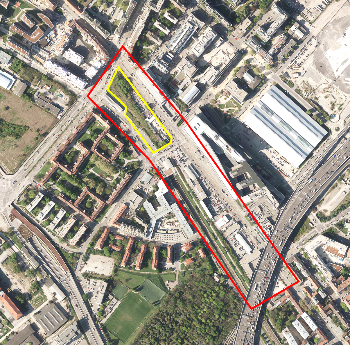
Localisation New Marx, Vienna, Autriche
Population 1 867 000 habitants
Site stratégique 6,5 ha – Site de projet 1,3 ha
Site proposé par WSE Wiener Standortentwicklung GmbH
Acteurs impliqués Ville de Vienne, WSE, Compagnie des Chemins de Fer Autrichiens
Propriétaires du site WSE, Compagnie des Chemins de Fer Autrichiens
Phase post concours Implication post-concours dans un processus de réalisation
Représentant d'équipe Architecte - urbaniste - paysagiste
Information complémentaire
How can the site contribute to a productive city?
Vienna’s concept for the productive city emphasises the value of the manufacturing sector and secures it as a key pillar of sustainable urban development. Embedded in this progressive framework the E15 site builds a mosaic within the larger zone of an ambitious transformation for a mixed-use-area of production and housing. A rather small plot of land, excellently accessible, it shall function as the ultimate experiment for mixing. Different interests need to be orchestrated and resilient synergies found. The site’s position within a traffic hub, its undulating topography, small size and wild nature will pose an extremely exciting and challenging task. The parameters for a mixed industrial site are set here. Amazed and inspired with a visionary pilot scheme for many to imitate.
City strategy
Facing a rapid population growth, Vienna has developed an ambitious plan to preserve, support and promote productive working places in the city. A new category ensuring a 50:50 mix of housing and production has been implemented in Vienna’s zoning plan, spanning the whole area of New Marx. The challenging brief is to pursue a resilient concept for an urban quarter with innovative typologies using this mix. There is, on the present day, a wide range of production from research, media and creative industries to trade and commerce plus new housing developments have been built or are underway making the site a great springboard for enhancing neighbouring potentials. Europan shall develop a cleverly thought-out network of synergies and smart solutions for a new togetherness.
Site definition
New Marx is located on a central urban and geopolitical axis, between the historic city centre and Vienna’s International Airport. The core profile of the larger site is its commercial use for science and technology as well as media and cultural industries. Together with all these companies situated in the area, the E15 site has ideal conditions to introduce a ground-breaking example mixing new residential typologies with innovative production facilities. The setting is unique - like an island it is framed by buzzing multilane streets, trams and bus lines with a new city rail station on one corner. Access is therefore excellent. Although surrounded by hustle and bustle, upon entering ‘the island’ its topography with its green wilderness grounds the site.
How is production inserted in the urban diversity programme?
One third of Vienna’s value-added features can be attributed to the manufacturing sector. The city has already identified commercial mixed areas as the ideal future for their productive metropolis in the heart of Europe. The E15 site is an intriguing part of a bigger scheme geared towards this essential goal. Therefore an expansion across the entire range of forms of living, working and producing is absolutely necessary. This expansion, which should make use of all manner of synergies and urban interventions, will shape and nurture a resilient community and must continue to work for future generations. At first glance the site’s dichotomy with the juxtaposition of heavy traffic and green spaces and its programmatic mixing of residential and production areas seem to be incompatible.
Find a thorough, comprehensive approach to deal with noise, densities, levels, position of volumes and front and rear elevations in order to come up with a fascinating new conglomeration where all the different uses nd new proximities. Nothing less is asked for than a stimulating and promis- ing project that can succeed in transforming our cities.
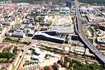 Arial view of the site and its surrounding
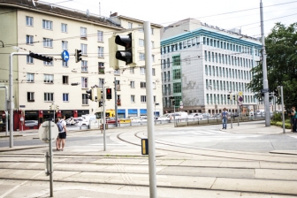 Streetscape - Rennbahnweg crossing Landstraßer Hauptstrasse
 The project site - bikeline towards station building
 Current car park on the site
Questions à propos du site
On page 21 it is said that the buildings of the car dealerships can be demolished. Does this also apply for the other car dealership buildings located within the strategic site along Rennweg, outside the project site, i.e. should proposals assume that eventually no pre-existing buildings will be preserved?
The brief on page 21 refers to the project site. The role of the strategic area is to establish an urban framework, which supports the ideas of the project site. Hence, the strategic site is meant to deliver a vision for a future development process, which can answer the questions of the brief. Depending on your concept, it is up to you to work with the existing built form on the strategic site or not. This does not apply to the station building. The station building has to be kept.
The A23 motorway passes over the south end of the strategic site, could you provide its clear height or give a max building height at this section (that is assuming the existing building should not be preserved as is)?
The clear height of the A23 motorway is about 11 metres. The max building height in this area is about 8 metres.
All building activities affecting the motorway have to pass additional planning permissions according to motorway regulations.
How is the height of a building measured - from adjacent street level or adjacent terrain - these are different due to the mound at the north side?
In In case the grown topography changes on different sites of the building, the height has to be measured from the lowest level of grown external ground.
Are there regulations or guidelines for density and intensity coefficients, distance of buildings from the site borders and between one another?
according to the brief: Density & Heights (pg 23) The maximum building height for any built structure must not exceed 35 meters. This includes lift overruns, chimneys, flues or any other projections above roof level, so that the building effectively has to end at 33 meters. A desired density can be assumed at a floor-space index of 3,5 which leads to approximately 50.000 squaremetres overall.
Further explanation on regulations can be found in the download section: AT-WIEN-Regulations-20190508.pdf
Please note that this file will be uploaded tomorrow, Thursday 8th of May.
What is meant by 'surface cubage' when talking about the 50% restriction on residential uses? Is it 50% of the total built area or 50% of the built volume?
surface cubage’ = built volume.
Therefore it means 50% of the built volume.
It is said that housing is restricted 'to not more than 50% of the whole cubage per development area'. Does this requirement apply to the project site independently from the rest of the strategic area, i.e. what is considered 'development area' - the project site or the strategic site?
The 50/50 rule applies to the project site and to the strategic site. However the project site must comply with this rule independently of the strategic site.
"The design proposals for the building masses on the project site should make an independent development at the north end possible (see plan ...)" Which plan is it or is the project site as a whole meant as the 'north end'?
The ownership structure of the site might lead to an implementation in two stages*. Therefore the design must allow for that. Important is the fact that each phase shows the intention of the overall idea, namely to mix and combine production and housing. Also, in both independent implementation phases the 50/50 rule must be fulfilled. Important is that the two stages can be developed independently of each other.
*see file "AT-WIEN-phases.pdf" in the download section
Devons-nous prendre en compte la densité de 3.5 comme valeur de référence ?
New discussions have resulted in a differentiated view on the issue of the total ground floor area: The density of 3.5 should not be seen as a fixed quantity. The teams themselves shall consider, according to principles of urban design-qualities, the agreeable amount of a maximum density. They shall therefore explore, if a higher number of total floor area is compatible with the goals of the brief, testing the feasibility of a critical density while keeping the criteria of porosity and spatial quality for the indoor and outdoor spaces. Especially the site’s function of bridging the different quarters, and to act as a stepping stone towards the new development area, is a key topic.
In the brief it is specified that "There is an abundance of plants unique to this neighbourhood covering the mound with some remarkably tall trees which makes it an incubator for biodiversity". Is a survey of the plants and trees available? And/or a report specifying the significantly important types of plants and trees?
There are no significantly important types of plants and trees on the site known to Europan, nor are there further reports available on such issues. The biodiversity of the site is one of various aspects through which the uniqueness of the site is represented in relation to its surroundings.
Topography terrain is not uploaded yet on folder site, when do we get this information?
The file "AT-WIEN-Siteplan-20190428.dwg" / "AT-WIEN-Siteplan-20190426.pdf" includes information on height levels. A sole topography map is not available.
Open railway track situated on the strategic site. Concerning to this part is there any regulation from transport authorities that defines the changes could be taken on?
All building activities within the building prohibition area require additional planning approval according to railway regulations.
Please see also the diagram AT-WIEN-Diagram-distance-railwaytracks-20190607.jpg
Closing the open track section is not allowed. In regards to cantilevering components that might protrude into the track space, railway regulations won’t approve anything that could jeopardize the railway traffic in any way.
Building over the tunnel is possible but implies structural improvement on the building itself, so that additional weight is taken up internally by the building and will not affect the structure of the tunnel.
Is there any requirement for the density that should be aquired on the project site?
Please see answer already given on a former question. „New discussions have resulted in a differentiated view on the issue of the total ground floor area: The density of 3.5 should not be seen as a fixed quantity. The teams themselves shall consider, according to principles of urban design-qualities, the agreeable amount of a maximum density. They shall therefore explore, if a higher number of total floor area is compatible with the goals of the brief, testing the feasibility of a critical density while keeping the criteria of porosity and spatial quality for the indoor and outdoor spaces. Especially the site’s function of bridging the different quarters, and to act as a stepping stone towards the new development area, is a key topic.“
Please clarify on the term "independent development at the north end" on page 24 in the brief (under project site>positioning as a hub)
The site has different owners, shown in the document “AT-WIEN-phases.pdf”. As it is not yet clear, if both owners will start the project at the same time, the proposal must allow for an independent development. In the brief on page 24 this is referred to, describing the smaller part with “the development at the north end” (blue-coloured-area).
Please clarify on the phases blue and yellow in the document "AT-WIEN-phases"
The blue and the yellow coloured areas on the plan "AT-WIEN-phases.pdf" show the different ownership structure of the site. This ownership structure might lead to an implementation in two stages. Therefore the design has to allow, that on the whole plot two projects can be developed chronologically and spatially independent from each other.
Is it possible to bridge-over / close evenly the current open train-tracks opposite the school building (HTL), as it seems that a structure has already been laid out for that? If so, what area could be closed off, so enough height is still left for the trains below?
In order not to jeopardize railway traffic, which includes also the transport of dangerous goods, bridging-over (a broad bridge as it were) is normally not permitted. In individual cases, depending on the situation, there may be exemptions. However, this cannot be granted here and by all means would require additional planning approval according to railway regulations. It is conceivable, that competitors present such an intention as an added value. Yet, the strategic concept and the project has to work without the option of bridging-over.
The PDF AT-WIEN-MinutesSiteVisit-20190429.pdf states that is possible to build underground, but how many levels or meters down?
Due to economic aspects, a maximum of 2 underground levels should be planned.
The PDF AT-WIEN-MinutesSiteVisit-20190429.pdf states that the T-Center is partially vacant now, with 14.000m2 available. Is this due to the building typology being difficult to adapt to new uses? Could you also clarify why "The percentage of empty office spaces in the surrounding area (Wien Erdberg) is higher than in the rest of Vienna"
The building typology of the T-Center is one of the reasons for the high number of empty office space. In the area Wien Erdberg the percentage of empty office space is higher than in the rest of Vienna because in the last few years new office districts such as the development around Vienna’s’ Main Station were realised, which have better access to public transport.
Competition Brief - page 21 paragraph 3. "On the corner...is one of the two entrances to the S7 station..." We can only identify one entrance at the corner of the project site. Could you please clarify where is the second one (directly accessed from the site)?
The second entrance of the S7 station is not on our site. It is located at the Fred-Zinnenmann-Platz, which is located Northwest of our site.
Competition Brief - page 21 paragraph 3. "Situated on Leberstrasse is a public car park, mainly used by residents of the Wildganshof" Shall we provide with parking space for the Wildganshof residents in case of removing/building up this parking space?
The project needs to provide parking spaces for the uses of the project site itself. (according to regulation: 1 parking space / 100m2 gross floor area). Currently approx. 100 parking spaces are situated on the site, which are used by neighbouring areas and might have to be kept in the future. However, the focus of the project lies on the overall concept and strategy for the area and not on the distribution of single parking spaces.
Competition Brief "The design proposals for the building masses on the project site should make an independent development at the north end possible (see plan ...)" Do you mean as "north end development" the phase blau in the AT-WIEN-phases.pdf? What is the grey border between phases in the same PDF? And, is any of the phases first to happen?
Yes, you are correct: the blue area is referred to as the “north end development”. The grey border between the two phases is the zone, where overlaps of both phases are possible. The design for the entire plot has to allow for two projects to be developed chronologically und spatially independent from each other.
Could we exceed the project/strategic site limits for integrating the surroundings? Such as bridges, pedestrian crosswalk, cantilevers etc
The strategic site was defined to include crucial surrounding areas that could provide enough context for the overall vision of the wider neighbourhood. However, if it is necessary for your concept to include more area, please do so!
On the web site, sites > vienna we can read that the owner of the site is: WES, Austrian Railway Company while in the PDF of the phases (New_Docs_After_Launch at-wien-phases.PDF) the blue phase reads as IM Immo Invest. This is a private developer not stated on the website.
The site belongs to various owners. WSE is the official partner of the Europan15 competition. It is correct that the area shown in blue colour on the plan "AT-wien-phases.PDF“ mainly belongs to IM Immo Invest.
Le site est lié au thème suivant
IMPLANTER IMPLANTER Usages productifs
Usages productifs
Pour que les villes deviennent à la fois productives et durables elles doivent relier les ressources, les mobilités et les conditions d’équité pour créer de nouvelles dynamiques selon deux aspects : des milieux productifs et des usages productifs.
Les usages peuvent devenir productifs s’ils dépassent leurs propres limites fonctionnelles : les usages productifs fonctionnent comme un déclencheur qui peut initier des dynamiques d’évolution de manière à transformer l'environnement autour. Ils sont une réponse à une situation dans laquelle l’absence de dynamiques a provoqué une « ambition d’usage » puissante, l’exigence d’un programme crédible, un catalyseur de changement qui s’insère parfaitement dans le contexte existant.
Questions à propos du site
Pour pouvoir poser une question, vous devez être connecté (et, par conséquent, inscrit au concours).
Ve. 16 mai 2025
Date limite de soumission des questions
Ve. 30 mai 2025
Date limite de réponses aux questions
Avant de soumettre votre question, assurez-vous qu'elle n'apparaît pas déjà dans la FAQ.
Merci de poser vos questions sur les sites dans le menu Sites.
Merci de poser vos questions sur le règlement dans le menu Règlement.
Si votre question ne reçoit pas de réponse dans les 10 jours, merci de vérifier qu'elle ne figure pas dans la FAQ sous un autre intitulé ; sinon, contactez le secrétariat concerné par email (secrétariats nationaux pour les sites, secrétariat européen pour le règlement.)