Wernigerode (DE)
Les Dossiers synthétiques et d'enjeux sont disponibles gratuitement.
Merci de vous inscrire et vous connecter pour accéder au Dossier complet de site.
- Dossier synthétique DE | EN
- Dossier d’enjeux DE | EN
- Le site sur Google Maps
- Retour à la carte
Données synthétiques

Wernigerode (DE)
Scale S, M architectural and urban scale
Team representative Architect, landscape planner
Location Town of Wernigerode, Saxony-Anhalt, Deutschland
Population c. 32,810 inhabitants
Strategic site c. 22.37 ha - Project site c. 8 ha
Site proposed by GWW
Actors involved GWW, City of Wernigerode
Owner(s) of the site GWW Gebäude- und Wohnungsbaugesellschaft Wernigerode mbH
Commission after competition Realization of two residential buildings 2023–24
Information complémentaire
Urban City Strategy
The town of Wernigerode, in Saxony-Anhalt on the north side of the Harz Mountains, is known nationwide as a tourist destination. Its topographical situation only allows for urban expansion northwards. Population figures are stable with a slight downward trend in recent years. There are hardly any vacant flats available for young families to rent in the city. Most families therefore move to surrounding municipalities. GWW Gebäude- und Wohnungsbaugesellschaft Wernigerode mbH wants to change this situation by developing new areas in the city.
Site Definition
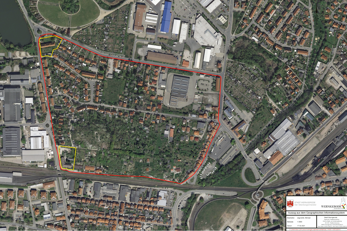
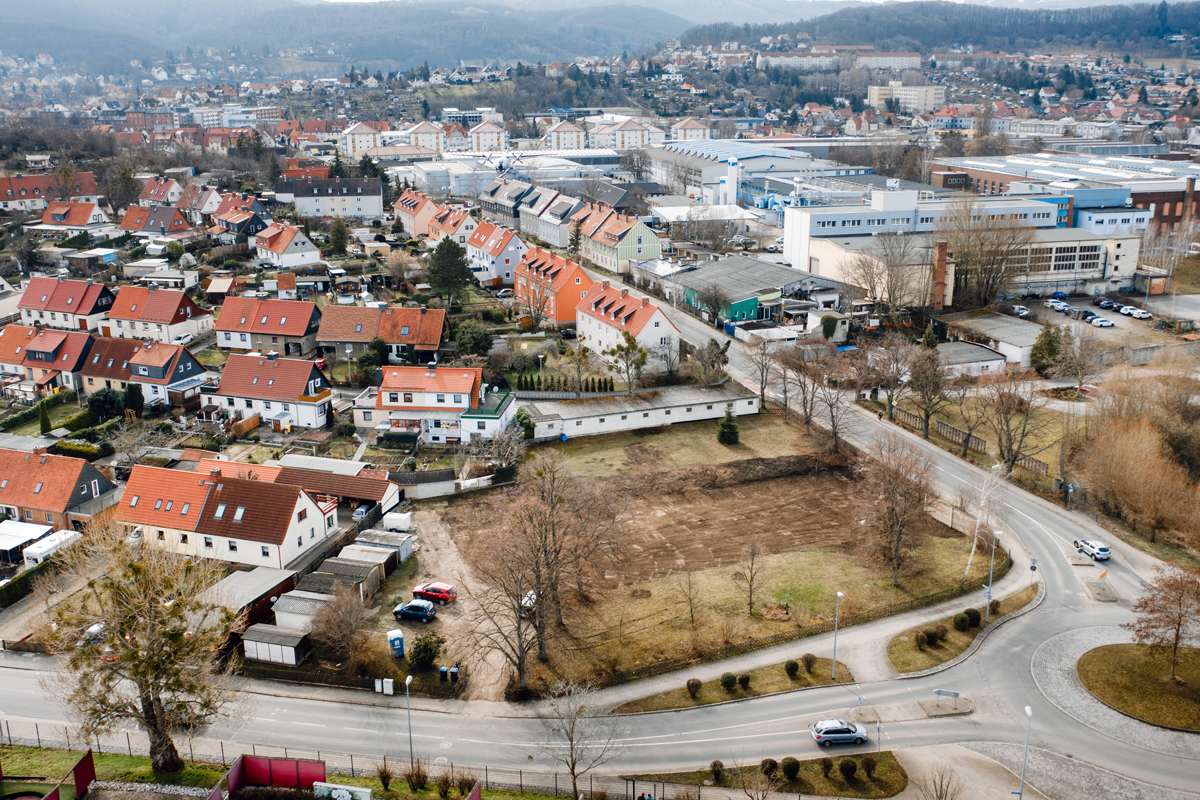
The area under consideration (including both competition sites) is in the north-western part of the town, separated from the historic town centre by the Hannover-Halle (Saale) railway line. The development is heterogeneous: large-scale commercial enterprises, 2- to 4-storey residential buildings (single-family homes, apartment buildings, terraced houses), and garden plots. To the north is the Bürgerpark, the site of a former garden show with extensive grassy areas, lakes, and various recreational uses.
The main railway station is nearby and can be reached in ten minutes over the pedestrian and bicycle bridge to the west of the main station and an underground crossing area on Schlachthofstrasse. Veckenstedter Weg skirts the area on the east.
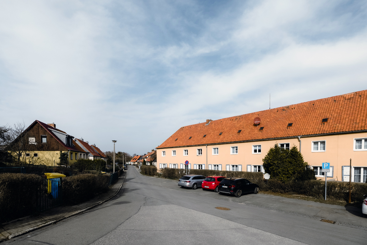
The neighbourhood is framed by four roads and was all developed at much the same time. Two through roads with low traffic frequency provide inner linkage. The housing development on the north-western corner, dating from ca. 1890–1930, was designed as housing for factory workers and staff. The large gardens were envisaged as self-supporting. Other green areas are now used as allotments and growers’ gardens or are derelict. There is a kindergarten on Giesserweg, but currently no other facilities of a social nature.
The process aims to develop a sustainable and ecological mixed-use framework plan, with a view to practicable development in smaller building and development phases. As a prelude, the two project sites 1 and 2 should be understood as framework and initiation projects
How Must Metabolism and Inclusivity Be Developed and Connected?
The two project sites mark the corners of a space that is today largely garden land with some small-scale development (former growers’ gardens). From an urban planning point of view, it would be interesting to link traditional concepts from the garden city and settlement movements with the increased attention now being given to green spaces in the town for social and ecological reasons.
The internal development of cities, which makes sense from an ecological point of view (reductions in land use, sealed-surface areas, traffic requirements), means that today’s open spaces must be more than places of contemplation or ecosystem services. They can make an important contribution to socio-ecologically sustainable urban development, both as community gardens and as sites of local food production.
There are no plans to build on the study site in the near future, but suggestions should be offered about what the future ‘Living City’ could look like. Current debates – such as the populist polarization between ‘single-family homes’ on the one hand and ‘prefabricated housing’ on the other – show the urgent need for more differentiated proposals and new ideas of urban living (‘urban imaginaries’), which can serve as models far beyond Wernigerode.
Ideas for continuing diversity of use and for a mixture of housing with an integrative character are desirable. Propositions on sustainability and the circular economy are also welcome. Also appropriate would be a mobility and energy concept that is adaptable to the future.


Questions à propos du site
Is there DWG-material of roads and building heights/storey numbers? This would help in making the design adapt to the current building stock and infrastructure. This information would also help to make a high-quality, feasible design.
Your question has been passed on to the city. The topogaphy of the sites will be recorded and given to you as soon as possible.
There are not more dwgs with story hights from the sourrounding buildings.
https://www.lvermgeo.sachsen-anhalt.de/de/leistungen-3d-gebaeudemodell.html
Maps of the topography are missing, could those be added? It would be crucial to know if there is a change in topography in the site. According to the areal views, the site seems to have big changes in topography. It is hard to adapt the design to the landscape without this information. DWG maps with height contours would be the most useful format.
Data has been uploaded on the server!!
Will the site visit take place on the 27 May 2021, 14:00-18:00 at the roundabout Veckensteter Weg / Zaunwiese and we can participate in person? Or will it not be possible due to corona?
You are cordially invited to take part in this event in compliance with the applicable hygiene regulations (distance and mask).
What is the need for parking in the project sites? Are the parking palaces supposed to be located in the project sites or can they be located somewhere else? How many parking places are needed for each site?
Is there a parking norm for the framework plan (e.g. parking space / m2 or parking space / apartment)?
Concerning the question of parking spaces. There is a parking space key for Werningerode:
Multi-family houses: 1-1.5 parking spaces per unit; according to other uses also less.
Apartments for the elderly: 0.5 parking spaces per unit
However, exemptions are possible; as a rule, the owner must pay a fee, which in this case is 2000 € per parking space.
Underground parking the is initially a matter for the developer. From an urban planning point of view, there is nothing to be said against it.
Red Area: -A) Are we supposed to to a design proposal (with new buildings and open spaces project) of the red area? If yes, which are the number of storeys, number of floor spaces (density and distances), amount of flats or gross floor area? B) If we have to design the entire red area, what can or can’t demolish in the area?
A) Yes, please. There are no specific requirements for the number of floor spaces or stories. See also question above.
B) Further demolition will not possible, because it is private property.
Red Area: -How are functioning at the moment the gardens in the area? Are they public or private? is there any production chain related to them? Are accessible freely form the public visitors? Is there any partecipated activity happening?
The gardens in the red area are private; outside the area under consideration (in the direction of Bürgerpark) there are allotment gardens leased by the town of Wernigerode. Private gardens are, of course, not freely acessable. There are no partecipated activities.
Red Area: -Is Am Galgenberg a private street? Is there the possibility to work on it or modify it?
The street "Am Galgenberg" is a public street - ideas for it are of course possible.
Yellow Areas: -Which are the GFZ, GRZ and maximum buildings height to be considered while designing the two areas? -Do we have to provide a specific plan for Firemen or Noise reduction? Which are the regulation to relate to designing the residential buildings for firemen regulations?
Answer GWW: At least 3.5 floors. For the firemen regulations - see Saxony-Anhalt State Building Code
Answer city of Werningerode: No concrete specifications are made regarding the number of floor areas and the number of storeys. In principle, the Building Code must be observed - according to § 34 BauGB, the project must adapt to the surrounding area in terms of type and degree of building use as well as the area of the plot that can be built over.
You do not need to draw up a fire plan or noise protection plan - Europan is a competition and not a building application procedure.
Yellow Areas: -Which are the regulations regarding distances from the train track?
Distances have to be according to the distance areas of the State Building Code (LBO) - whereby the GSW property is not directly adjacent to the railway line and is therefore not relevant in the distance area calculation.
Yellow Areas: -Is there any informations about the topography and height-lines? -It´s the building in the southern yellow plot being demolished yet?
Surveying of the site has been carried out, documents should be available at the beginning of July and then made available to Europan.
Have existing buildings already been demolished? (Reuse the material of demolition/ use the old foundations for new buildings - as an archeological element)
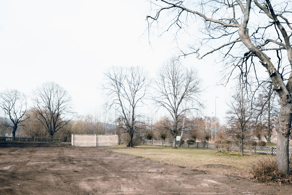
One has been demolished already, the other one will be - in July 2021. Reuse of materials is not possible - because of pest and fungal infestation.
Are there precise limits to the project area? (h. max. / volume - distances)
As can be seen in the tender documents (aerial photograph), the red line indicates the neighborhood framed by the road running almost around it, as well as railroad tracks on one side. The yellow lines show the project area, bordered in each case by the property boundaries.
-where can we find more info about the industrial context?
In the explanatory memorandum of the land use plan - see table of contents of the land use plan (www.wernigerode.de).
We do not have any further historical documents/publications.
Is it possible to receive the report (Gutachterbericht as mentioned on the site visit) of the conditions of the existing building (Bausubstanz) in the southern part of the site? Are there any drawings (floor plans, sections, elevations) of this building?
There are no drawings available. The second building will be demolished in July 2021.
Which part of the study site / project sites can be supplied with district heating?
The northern project area, at the Veckenstedter Weg by the traffic circle, can be developed with district heating (transfer line is located at the entrance to the property).
The southern plot (rail) cannot be developed with district heating.
Could you add to the site documents a .dwg file with topographic information?
The documents have been uploaded. See folder "New Documents after Launch" on the server!!
In the German brief, you ask us to develop a Behoerden and Dienstleitsungszentrum. In the English brief we read it a little differently. If we should develop a Behoerden and Dienstleitsungszentrum, how many square meter or how much % of office spaces should we plan?
Dear participants, you are right - the passage 3.1. on page 6 in the german brief is incorrect. Please take the english version! Sorry for the mistake. We changed the german version and uploaded the page in the "New Documents" File.
We find a Flurkarte by the city of Wernigerode that explains a building and a greenspace area on the project site. Do we have to follow this demarcation or are we free to propose a different organization of building mass and green spaces with in the site?
Dear participant, could you specify your question please? I dont quite understand. The sites (yellow are) are clear of buildings.
What do you mean with “urban imaginaries” in the competition brief?
Dear participant, thank you for this question. It is basically a way of envisioning the future. To read further: https://www.researchgate.net/publication/332222833_Urban_Imaginaries_and_the_Palimpsest_of_the_Future
How is the ownership of the various different sites (Flurstücke) within the study area?
Private or GWW, see plan
Generally speaking; what is the ownership / Tenure-ship status of the informal gardening communes? And are the gardening plots related to the more formal housing structures to the North west corner of the study site, (around project site 1)
The gardens are private.
Which plots are public, and which one are private in the Study Site? Will the public institutions buy further plots for shared spaces in the future ?
Only the paths/roads are public, see plan. No land purchases are planned on the part of the city of Wernigerode.
Which uses are intended for the buildings on the two sites? The german version of the site brief describes a mixed use building with a kindergarten, big event area and a service center of the local authorities (site brief p6 german version). In the english version as well as in the chapter „task“ of the german version, only housing is mentioned.
Your question is very helpful, thank you. You are right: there was a little mistake on page 6 in the german brief (point. 3.1.). The correct text is the english one!
Can you please share a detailed report of the site visit on the 27 May 2021? Usually, it was provided and it is important for those who were not able to attend the visit, because of pandemics. Thanks. We read in the Europan Calendar “A report is available on the European website within a maximum of 2 weeks after the site visit”
Dear participants, the formal "report" is the documentation video. However, the translation the questions and answers from the colloquium have been posted on the server!!
Can we change the soil levels, digging?
Yes
Are there any noise restrictions? With blind walls / non-opening windows?
Not known yet, these questionas are subject of the (later) approval phase.
What are the distances to consider between the new buildings and the site plot boundaries, in the yellow areas?
Distance areas in accordance to the building code must be observed.
Is it necessary to follow local legislation? Or for this level of competition, the compliance with all regulations is not relevant and evaluated? And if so, what is the relevant legislation? Can you share it in English?
In its implementation, the design must of course be compatible with the provisions of the building codes and regulations. (Project is subject to approval).
In the red zone: what can be kept and what can be demolished?
Since these are private areas, the approach should be to leave them as they are. The design should therefore function in the context of the current urban structures. Finding a new urban development approach as an idea is not required, but it is possible.
Yellow area: what is the maximum roof height? How many floors should be the building? minimum and maximum?
Please look at the other questions, this was answered before.
Are there any prescriptions regarding teh roof? Pitched or flat roof?
There are no specific requirements regarding the shape of the roof. In principle, buildings should fit appropriately into the urban landscape and reflect the character of the city.
What is the soil nature of the hill in the entire red area? Is it Natural or made by debris? Is it a polluted area?
The soil is grown, and there are no known areas of suspected contamination.
What size should the apartments of the buildings in the yellow area have? Is there a minimum and maximum size? What are the percentages of the different sizes and types? What types are preferable?
The Europan competition is entitled "Living Cities". We would like to see a wide range of different housing options. Deciding exactly how this can be achieved. - in what number and size is up to the participants. We support innovative ideas and proposals
Who are the new inhabitants of the new housing buildings in the yellow areas? a Mix of Young people, families, old people?
The buildings are to be developed for a variety of different residents and users. Particular emphasis is to be placed on affordable housing.
Will the industrial context outside the yellow area be urbanized as residential?
There are no plans to change industrial and commercial areas into residential areas.
Yellow area: how much is it possible to build? What should be the new urban density? How many cubic meters or sqm you expect more?
As you can see in the answers to the other questions: there are no specific requirements regarding floor area ratio etc. Only the vage number of flats in the competition brief.
What are the functions planned on the ground floor of the new buildings in the yellow area?
There are no spicific funktions planned yet - that is the Europan task, and therefore has to be answered by you.
We saw the video of "Europan_Wernigerode_Visit and colloquium for questions_27 May 2021 ". However, it is in German. Is it possible to have a report in English? or a translation of the video? It would be important in order to let the architects from abroad understand, giving the same information to all.
Thank you for that question. Du to corona we did the films instead of the reports. They are the documentation of the site visit and the colloquium. However, we also tanslated a written version of the questions and put them online. Please check the europan Europa server.
Le site est lié au thème suivant
Revitalisation Sur ces sites, l'impulsion de la transformation vient du territoire et de l'utilisation de toutes les ressources (naturelles, écologiques, infrastructurelles) pour le régénérer.
Rendre les territoires performatifs
Ici, le territoire a besoin de se reconnecter à son contexte social pour ajouter de nouvelles qualités créatives et culturelles.
Documents spécifiques
Questions à propos du site
Pour pouvoir poser une question, vous devez être connecté (et, par conséquent, inscrit au concours).
Ve. 16 mai 2025
Date limite de soumission des questions
Ve. 30 mai 2025
Date limite de réponses aux questions
Avant de soumettre votre question, assurez-vous qu'elle n'apparaît pas déjà dans la FAQ.
Merci de poser vos questions sur les sites dans le menu Sites.
Merci de poser vos questions sur le règlement dans le menu Règlement.
Si votre question ne reçoit pas de réponse dans les 10 jours, merci de vérifier qu'elle ne figure pas dans la FAQ sous un autre intitulé ; sinon, contactez le secrétariat concerné par email (secrétariats nationaux pour les sites, secrétariat européen pour le règlement.)